
 Country
Africa
Somalia
Somalia is a country on the eastern tip of Africa. It has a very long coast, hot dry land and lots of camels.
Somalia is the easternmost country of Africa, on the Horn of Africa between the Gulf of Aden and the Indian Ocean. Most of it is flat, hot and dry, with thornbush savanna, and camels, goats, sheep and cattle are its greatest farm wealth. Its capital is Mogadishu.
Somalia occupies the Horn of Africa, stretching from just south of the Equator to the Gulf of Aden, a largely flat tableland of young limestone and sandstone with arid to semiarid climates. About three-fifths of its people follow nomadic or agropastoral ways of life, and the World Bank estimated its population at 19.65 million in 2025. Since the central government collapsed in 1991, the country has been split into areas under different authorities, and the federal government declared in 2012 had only limited control.
Photo: Yusuf Dahir, public domain, via Wikimedia Commons
Discover Somalia
Somalia is a country in Africa.
It is at the eastern tip of Africa, called the Horn of Africa. The sea is on two sides. Much of the land is flat, hot and dry. The capital city is Mogadishu.
Somalia is the easternmost country of Africa. It sits on the Horn of Africa, a point of land that sticks out into the sea. The Gulf of Aden lies to the north and the Indian Ocean to the east, and Somalia stretches from just south of the Equator all the way up to the Gulf.
Apart from mountains near the northern coast and a few river valleys, most of Somalia is very flat. The climate is mainly hot and dry, with thornbush savanna and semidesert. The capital, Mogadishu, is a port on the Indian Ocean just north of the Equator. The World Bank estimated that about 19.7 million people lived in Somalia in 2025.
Somalia is the easternmost country of Africa, on the Horn of Africa. It extends from just south of the Equator north to the Gulf of Aden, and Britannica notes its important position between sub-Saharan Africa and the countries of Arabia and southwestern Asia. Its land neighbors are Kenya and Ethiopia to the west and Djibouti to the northwest.
The Somali peninsula is mainly a tableland of young limestone and sandstone. Except for a mountainous coastal zone in the north and several deep river valleys, it is extremely flat, with few natural barriers to the movement of herders and their livestock. Conditions range from arid in the northeast and center to semiarid in the northwest and south. The World Bank's estimate for 2025 was 19.65 million people, though other estimates differ: Britannica's for 2026 is about 22.3 million. The capital, Mogadishu, lies on the Indian Ocean just north of the Equator.
Cities and old ports
Mogadishu is the capital of Somalia.
It is a city by the ocean. Hargeisa is a big city in the north. It sits in a valley high in the hills. Old port towns line the long coast.
Mogadishu, the capital, is a port on the Indian Ocean. It began more than a thousand years ago, in the 900s, as one of the earliest Arab settlements on the East African coast, and it became the capital of independent Somalia in 1960.
Somalia has other old trading towns along its coasts, including Kismaayo, Baraawe and Marca in the south and Berbera on the Gulf of Aden in the north. Hargeisa, a large city in the northwest, sits in an enclosed valley in the highlands, about 1,334 meters above sea level. Herders have long brought their animals there to water and trade them.
Mogadishu, one of the earliest Arab settlements on the East African coast, dates to the 10th century. It traded widely with the Arab states, then had commercial links with the Portuguese and the imams of Muscat before coming under the sultan of Zanzibar in 1871. Leased to Italy in 1892 and sold to it in 1905, it became the capital of Italian Somaliland and, in 1960, of independent Somalia. Its National Museum was housed in the former palace of the sultan of Zanzibar.
Britannica describes the old coastal trading centers, Kismaayo, Baraawe, Marca, Mogadishu, Berbera and Boosaaso, as places where population is concentrated. Hargeisa lies in an enclosed valley of the Galgodon (Ogo) highlands at 1,334 meters. It was first the summer capital of British Somaliland and its administrative center from 1941, and it grew as a watering and trading place for nomadic herders, whose meat, livestock, skins and ghee are exported through Berbera, 188 km to the northeast.
Plateaus, rivers and four seasons
Most of Somalia is flat and dry.
Tall hills rise in the north, near the sea. Two rivers flow all year in the south. Somalia has two rainy seasons and two dry seasons.
In the far north, a narrow coastal plain runs along the Gulf of Aden, and behind it rise steep mountains. The highest, Surud Cad near the town of Ceerigaabo, reaches about 2,408 meters. South of the mountains, wide plateaus slope gently down toward the Indian Ocean, and in the south a belt of ancient sand dunes runs along the coast for more than 1,000 kilometers.
Only two rivers flow all year, the Jubba and the Shabeelle, which start in the highlands of Ethiopia. Somalia has four seasons: the gu, the main rainy season from April to June; the dry xagaa; the second rains, called dayr, from October to December; and the long dry jilaal. At Berbera, on the northern coast, afternoon highs average more than 38 °C from June to September.
Along the Gulf of Aden lies the Guban, a narrow coastal plain, which gives way inland to a maritime range with a steep north-facing scarp; near Ceerigaabo, Surud Cad reaches about 2,408 m. To the south the Galgodon (Ogo) Highlands and the Sool and Hawd plateaus descend toward the Indian Ocean. In the south, granite inselbergs outcrop near Baydhabo, and alluvial plains are separated from the coast by a dune belt more than 1,000 km long. The Dharoor and Nugaaleed are seasonal wadis; the Jubba and Shabeelle, rising in the Ethiopian highlands, are the only permanent rivers, and the Shabeelle sometimes dries up in its lower course.
The year has four seasons: gu (April to June) and dayr (October to December) are rainy, jilaal (December to March) and xagaa (June to September) dry. Mean annual rainfall is under 100 mm in the northeast, 200 to 300 mm on the central plateaus and 500 to 600 mm in the southwest and northwest. Afternoon highs at Berbera average more than 38 °C from June to September, while the Indian Ocean coast is cooler because of a cold offshore current.
Herds and wild animals
Camels are very important in Somalia.
Goats, sheep and cattle are too. Wild lions, leopards and ostriches live there. Some trees give sweet-smelling resin called frankincense and myrrh.
Somalia's greatest resource is its pastures, and its livestock is mostly goats, sheep, camels and cattle. Raising these animals is worth far more than growing crops.
Many wild animals still live across the country, especially in the far south: hyenas, foxes, leopards, lions, warthogs, ostriches, small antelopes and many kinds of birds. Thornbush savanna with acacias covers the south and northwest. In the moist northern mountains grows the frankincense tree, and the myrrh tree grows in the south and center. Both give fragrant resins that people have traded for centuries.
Vegetation follows rainfall: relatively dense thornbush savanna with succulents and acacias in the south and northwest, grassy plains with low thorny shrubs on the northern plateaus, and almost no plant cover in the northeast and much of the northern coastal plain. Frankincense (Boswellia) grows in the wadis and moist zones of the northern coastal mountains, and myrrh (Commiphora) in the border areas of southern and central Somalia. Britannica reports that inappropriate land use has heavily degraded the original vegetation, especially in the north, reducing forage for livestock and wildlife.
Livestock, chiefly goats, sheep, camels and cattle, is Somalia's greatest resource. Hyenas, foxes, leopards, lions, warthogs, ostriches, small antelopes and many birds still live in the country, especially in the far south, but giraffes, zebras, oryx, hippopotamuses, rhinoceroses and above all elephants have been greatly reduced, chiefly by ivory poachers. Nature reserves and national parks were created to protect endangered species, but Britannica notes they have been neglected since the central government collapsed in 1991.
People, languages and food
Most people in Somalia speak Somali.
Many also speak Arabic. Poems and songs are an important part of Somali life. Since 1973, Somali has been written with the same letters as English.
Somali people make up the great majority of Somalia's population, and Somali communities also live in neighboring Djibouti, Ethiopia and Kenya. Somalia also has Bantu farming communities along the rivers, Arab families mainly of Yemeni origin, and the Bagiunis, a Swahili fishing people on the coast near the Kenyan border.
The Somali language is understood all over the country. Arabic is the second official language, and Swahili is spoken in the south. Until 1973 Somali was not written down; then an official alphabet using Latin letters was adopted. Poetry, folk dancing, plays and singing are important traditions. Nearly all Somalis are Muslims. In the towns, cooking has been strongly influenced by Italian food.
The Somali people form the overwhelming majority, and Somali communities also live in Djibouti, Ethiopia's Ogaden region and northeastern Kenya, because the western border drawn by colonial powers divides lands traditionally occupied by Somali. Society is organized in clans that trace descent to a common ancestor. Minorities include Bantu farmers, who practice irrigation agriculture on the Jubba and Shabeelle, Arabs mainly of Yemeni origin, and the Bagiunis, a Swahili fishing people on the southern coast and islands.
Somali is a Cushitic language of the Afro-Asiatic family, understood throughout the country despite regional dialects; Arabic is the second official language, and English and Italian are used at colleges and universities. An official Latin-based orthography was adopted in 1973. Virtually all Somali follow the Shafi'i school of Sunni Islam. Britannica describes about two-fifths of people as living in settled communities and three-fifths as nomadic pastoralists or agropastoralists, with more than two-fifths of the population under 15. Poetry, folk dance, plays and song remain central to cultural life, and urban cooking shows strong Italian influence.
A history of trade
Long ago, ships came to Somalia's coast to trade.
Traders bought sweet-smelling gums and ostrich feathers. Busy port towns grew up by the sea. In 1960, Somalia became its own country.
For many centuries, Somalia's northern and eastern coasts were open to the world. Traders sold precious gums such as frankincense, ostrich feathers and ghee, a kind of clarified butter. Between the 600s and 900s, Muslim Arabs and Persians set up trading posts along the coast, and by the 900s port towns such as Seylac, Berbera and Mogadishu were trading as far away as China.
In the 1880s Britain made treaties with clans on the northern coast and set up a protectorate there, and from 1889 Italy gained land in the northeast and south, which became Italian Somaliland. In 1960 both parts became independent: the British north on June 26 and the Italian south on July 1, when they joined together as the Somali Republic. In 1973 Somali became a written language with an official alphabet.
The northern and eastern coasts probably formed part of Punt, the 'land of aromatics and incense' of ancient Egyptian writings. Between the 7th and 10th centuries Muslim Arab and Persian immigrants founded trading posts along the coast; by the 10th century Islam was firmly established in Seylac, Berbera, Marca, Baraawe and Mogadishu, whose trade reached as far as China. From the 10th century onward Somali groups expanded southward from the Gulf of Aden coast. Britain made protection treaties with northern clans in 1884 to 1886, and Italy, after acquiring protectorates in 1889, ran Italian Somaliland directly from 1905. The British protectorate became independent on 26 June 1960 and joined Italian Somalia, independent on 1 July, as the Somali Republic.
Mohamed Siad Barre held dictatorial rule from 1969 until 1991, when he was overthrown in a civil war; Britannica writes that warfare continued and the country lacked an effective central government into the 21st century. In 1991 a de facto government in the north declared an independent Republic of Somaliland in the northwest, with its capital at Hargeisa; it runs its own administration and issues its own currency. Internationally, Somalia's borders, which include that territory, are the recognized ones, and Somalia's government still claims Somaliland as part of the country. Somaliland has not received widespread recognition. A Federal Republic of Somalia was declared in 2012 with only limited control over the country.
Somalia on the map
Find Somalia on the globe.
It is in Africa, at the very eastern point. Its land bends around the corner of Africa. The Indian Ocean is on one side. The Gulf of Aden is on the top.
Somalia is in East Africa, on the Horn of Africa. On a map its land bends around the corner of the continent. The Gulf of Aden lies along its northern coast, facing Arabia, and the Indian Ocean lies along its long eastern coast.
Its land neighbors are Djibouti to the northwest and Ethiopia and Kenya to the west. Somalia reaches from just south of the Equator in the south to the Gulf of Aden in the north, so the Equator crosses its southern tip.
Somalia is bounded by the Gulf of Aden to the north, the Indian Ocean to the east, Kenya and Ethiopia to the west and Djibouti to the northwest. Britannica notes that the western border was drawn arbitrarily by colonial powers and divides lands traditionally occupied by Somali people, so Somali communities live in all three neighbors and the border remains a source of dispute.
The country extends from just south of the Equator to the Gulf of Aden, with its total area given as 637,657 square kilometers. The map highlights the whole internationally recognized territory of Somalia, including the northwest, where the self-declared Republic of Somaliland has its own administration and which Somalia's government claims. The northern mountains face the Gulf of Aden with a steep scarp; plateaus slope south and east toward the Indian Ocean, and the Jubba River reaches the sea north of Kismaayo, near the southern end of the coast.
- Position
- from just south of the Equator north to the Gulf of Aden
- Neighbors
- Kenya and Ethiopia (west), Djibouti (northwest)
- Highest mountain
- Surud Cad, about 2,408 m
- Coastal dune belt
- more than 1,000 km long
Amazing facts
-
Somali was first written with letters in 1973.
Until 1973, the Somali language had no official way of being written. Then an alphabet using Latin letters was adopted.
Somalia adopted an official Latin-based orthography for Somali in 1973; until then Somali had been an unwritten language.
-
Somalia has two rainy seasons and two dry seasons.
Somalia's year has four seasons with Somali names: gu and dayr are rainy, jilaal and xagaa are dry.
The gu rains fall from April to June and the dayr rains from October to December; the jilaal (December to March) is the main dry season and the xagaa (June to September) the second.
-
Frankincense trees grow in Somalia's northern mountains.
Frankincense trees grow in the moist parts of Somalia's northern mountains, and myrrh trees grow farther south. Both give sweet-smelling resin.
Frankincense (Boswellia) grows in the wadis and moist zones of the northern coastal mountains, and myrrh (Commiphora) in southern and central Somalia; aromatic gums have been exported from this coast for centuries.
-
Long ago, Somali port towns traded as far as China.
More than a thousand years ago, port towns such as Mogadishu and Berbera were already trading with lands as far away as China.
By the 10th century, the coastal towns of Seylac, Berbera, Marca, Baraawe and Mogadishu were engaged in a lively trade with connections as far as China.
Words to know
- peninsula
- a piece of land with water on most sides
- plateau
- a large area of high, mostly flat land
- wadi
- a valley that has a river only in the rainy season
- nomadic pastoralism
- a way of life in which people move with their herds to find grass and water
- frankincense
- a sweet-smelling resin from the Boswellia tree
- inselberg
- a steep rocky hill standing alone above a plain
- orthography
- the agreed way of writing a language with letters
Discovery challenge
-
What is the capital city of Somalia?
Which port city is the capital of Somalia?
Which Indian Ocean port, dating to the 10th century, became Somalia's capital in 1960?
- Mogadishu
- Berbera
- Kismaayo
Show the answer
Mogadishu
Mogadishu is the capital. It is by the ocean.
Mogadishu, a port on the Indian Ocean, is the capital. It began in the 900s as a trading town.
Mogadishu, one of the earliest Arab settlements on the East African coast, became the capital of independent Somalia in 1960.
-
Which two rivers flow all year in Somalia?
Which two rivers in Somalia flow all year round?
Which two rivers, rising in the Ethiopian highlands, are Somalia's only permanent rivers?
- The Nile and the Congo
- The Jubba and the Shabeelle
- The Niger and the Volta
Show the answer
The Jubba and the Shabeelle
The Jubba and the Shabeelle flow all year.
The Jubba and the Shabeelle start in Ethiopia's highlands and flow all year through southern Somalia.
The Jubba and Shabeelle are the only permanent rivers; the Shabeelle sometimes dries up in its lower course in dry years.
-
Which language do most people in Somalia speak?
Which language is understood all over Somalia?
Which Cushitic language, written in Latin letters since 1973, is understood throughout Somalia?
- Portuguese
- French
- Somali
Show the answer
Somali
Most people in Somalia speak Somali.
Somali is understood all over the country. Arabic is the second official language.
Somali, of the Cushitic branch of Afro-Asiatic, became a written language with an official Latin orthography in 1973.
-
In Somalia, what is the gu?
What is the gu in Somalia?
In Somalia's four-season year, what is the gu, from April to June?
- The main rainy season
- A tall mountain
- A kind of boat
Show the answer
The main rainy season
The gu is when the most rain falls.
The gu, from April to June, is the main rainy season. The dayr, from October to December, is the second.
The gu (April to June) is the main rainy season; it is followed by the xagaa dry season, the dayr rains and the jilaal, the main dry season.
-
Which ocean is on Somalia's long eastern coast?
Which ocean washes Somalia's eastern coast?
Somalia is bounded by the Gulf of Aden to the north. Which ocean lies to its east?
- The Arctic Ocean
- The Indian Ocean
- The Pacific Ocean
Show the answer
The Indian Ocean
The Indian Ocean is on Somalia's eastern side.
The Indian Ocean lies to the east, and the Gulf of Aden lies to the north.
Somalia is bounded by the Gulf of Aden to the north and the Indian Ocean to the east, with Kenya, Ethiopia and Djibouti on land.
Animals of Somalia
-
 Watch
3D
Animal
Dromedary camel
The dromedary, or Arabian camel, is the one-humped camel of the deserts of North Africa, the Middle East and India. Its hump stores fat, not water, and its body is full of tricks for saving water. People tamed dromedaries thousands of years ago, and today none live truly wild, except a large feral population in Australia.
-
 Watch
3D
Animal
Common ostrich
The common ostrich is the tallest and heaviest bird alive. It cannot fly, but it is the fastest runner on two legs, sprinting at about 70 kilometers an hour across the savannas and deserts of Africa. It also lays the biggest egg of any living animal.
-
 Watch
3D
Animal
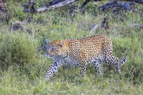
Leopard
The leopard is a strong, spotted big cat and the best climber of them all. It can carry its food high up into a tree, away from lions and hyenas. Leopards live in more kinds of places than any other big cat, from deserts to rainforests, across Africa and Asia.
-
 Watch
3D
Animal
Lion
The lion is the only big cat that lives in a family group, called a pride. Lionesses hunt together, males guard the pride's land, and their roar can be heard about 8 kilometers away. Wild lions live in Africa, plus one small group in western India.
Explore next
-
Watch
3D
Animal
Dromedary camel
The dromedary, or Arabian camel, is the one-humped camel of the deserts of North Africa, the Middle East and India. Its hump stores fat, not water, and its body is full of tricks for saving water. People tamed dromedaries thousands of years ago, and today none live truly wild, except a large feral population in Australia.
-
Watch
3D
Animal
Common ostrich
The common ostrich is the tallest and heaviest bird alive. It cannot fly, but it is the fastest runner on two legs, sprinting at about 70 kilometers an hour across the savannas and deserts of Africa. It also lays the biggest egg of any living animal.
-
Watch
3D
Animal
Leopard
The leopard is a strong, spotted big cat and the best climber of them all. It can carry its food high up into a tree, away from lions and hyenas. Leopards live in more kinds of places than any other big cat, from deserts to rainforests, across Africa and Asia.
-
Watch
3D
Animal
Lion
The lion is the only big cat that lives in a family group, called a pride. Lionesses hunt together, males guard the pride's land, and their roar can be heard about 8 kilometers away. Wild lions live in Africa, plus one small group in western India.
-
 Watch
 Country
Kenya
Kenya is a country in East Africa, crossed by the equator. It has the snow-capped Mount Kenya, the deep Great Rift Valley, Lake Victoria and a long Indian Ocean coast, and about 54 million people live there, many of them speaking Swahili.
-
 Watch
 Country
Ethiopia
Ethiopia is a country on the Horn of Africa with no coast. Much of it is high, rugged land cut by the Great Rift Valley, it is one of the world's oldest countries, and more than 110 million people live there.
-
 Watch
 Country
Democratic Republic of the Congo
The Democratic Republic of the Congo, or DR Congo, is the second-largest country in Africa. The mighty Congo River curves through its rainforests, volcanoes rise in the east, and its capital, Kinshasa, is a center of music, fashion and popular culture.
-
 Watch
 Country
Tanzania
Tanzania is a country in East Africa, just south of the Equator, on the Indian Ocean. It has Mount Kilimanjaro, Africa's highest mountain, deep lakes in the East African Rift, and the Serengeti, where huge herds of wildebeest travel each year.
For parents & teachers
What children will learn
- Locate Somalia on the Horn of Africa and name the Gulf of Aden and the Indian Ocean.
- Describe Somalia's dry plateaus, its two permanent rivers and its four seasons.
- Explain why herding goats, sheep, camels and cattle matters so much in a dry land.
- Outline Somalia's long history of coastal trade and its independence in 1960.
Recommended ages: 3 to 17 · About 15 minutes
Talk about it
- Why might people in a dry land move with their animals to find grass and water?
- What would change in your town if it had two rainy seasons and two dry seasons?
- Somali was first written with an official alphabet in 1973. How do people share stories and poems without writing?
Try at home or in class
- Draw a year as a circle and divide it into Somalia's four seasons: gu, xagaa, dayr and jilaal.
- On a map or globe, trace the Jubba and Shabeelle rivers from Ethiopia to the Indian Ocean.
Key vocabulary: peninsula, plateau, wadi, nomadic pastoralism, frankincense, inselberg, orthography
Where these facts come from
- Wikidata , Wikimedia Foundation (CC0 1.0)
- Natural Earth vector data , Natural Earth (NACIS) (Public domain)
- Somalia (introduction, Land: relief, drainage, soils and climate) , Encyclopaedia Britannica
- Somalia: Plant and animal life (with People: ethnic groups, languages, religion, settlement, demographic trends) , Encyclopaedia Britannica
- Somalia: Economy , Encyclopaedia Britannica
- Somalia: Daily life and social customs (with History: early trading towns) , Encyclopaedia Britannica
- Somalia: The great Somali migrations (with the imperial partition) , Encyclopaedia Britannica
- Somalia: Revolt in British Somaliland (to independence in 1960) , Encyclopaedia Britannica
- Mogadishu , Encyclopaedia Britannica
- Hargeysa , Encyclopaedia Britannica
- Population, total - Somalia , World Bank
- PlayOwl region table, version 1 , PlayOwl (PlayOwl original data)
- flag-icons 7.5.0 , Panayiotis Lipiridis and contributors (MIT)
- Wikimedia Commons , Wikimedia Foundation (Per file (public domain, CC0, CC BY or CC BY-SA); see each media record)
Checked, not yet human-reviewed. Last updated October 28, 2026. Spotted a mistake? Tell us.
Picture credits
- Photo: Yusuf Dahir, public domain, via Wikimedia Commons · source