
 Country
Africa
Tunisia
Tunisia is a country in North Africa by the Mediterranean Sea. It has olive farms, old stone cities and sandy desert in the south.
Tunisia is a small country in North Africa, with the Mediterranean Sea to the north and east. Its green, rainy north turns into dry steppes and then Sahara desert in the south, and about 12 million people lived there in 2024, many of them in the capital, Tunis.
Tunisia, in North Africa, stretches from about 37° to 30° N between Algeria, Libya and the Mediterranean. Its 2024 census counted 11,972,169 people, concentrated on the fertile north and the olive-growing east coast, and its ruins, from Phoenician Carthage to Roman El Jem and Arab Kairouan, record nearly 3,000 years of history.
Photo: Emna Trabelsi, CC BY-SA 3.0, via Wikimedia Commons
Discover Tunisia
Tunisia is a country in North Africa.
The Mediterranean Sea is on two sides. The north has green hills and lots of rain. The south has hot, sandy desert. The capital city is Tunis.
Tunisia is a country in North Africa. Algeria lies to the west and southwest, Libya to the southeast, and the Mediterranean Sea to the north and east.
In the north, mountains and valleys get plenty of rain in winter. Farther south the land becomes dry, grassy steppe, and the far south is part of the Sahara. About 12 million people lived in Tunisia in 2024. The capital, Tunis, is near the ruins of the ancient city of Carthage.
Tunisia lies between about 37° and 30° N, bounded by Algeria to the west and southwest, Libya to the southeast and the Mediterranean to the east and north. Britannica notes that its accessible Mediterranean coastline and strategic location have drawn conquerors and visitors through the ages, and that ready access to the Sahara has long linked its people with the African interior.
The National Institute of Statistics (INS) counted 11,972,169 people in the 2024 census, growing by about 0.87 percent a year; 22.8 percent were under 15, and the share of older people had risen to 16.9 percent from 11.7 percent in 2014. Britannica divides the country into four regions: the fertile, well-watered north; the semiarid center; Al-Sāḥil, the olive-growing east-central coast; and the desert south.
Cities and famous places
Tunis is the capital city. It is near the sea.
Tunisia has very old places. El Jem has a huge round stone arena. Dougga is an old town on a hill. Kairouan has a big old mosque.
Tunis, the capital, mixes old markets called souks and mosques with modern office buildings, and about one in five Tunisians lives in and around it. Sfax, on the east coast, is the center of Tunisia's fishing industry.
Tunisia has many ancient ruins. The amphitheater of El Jem, built in the 200s, could hold up to 35,000 spectators. Dougga, on a hilltop in the northwest, is considered the best-preserved Roman-African town in North Africa. Kairouan, founded in 670, has a Great Mosque with columns of marble.
Tunis blends old souks and mosques with modern office buildings; about one-fifth of the population lives in its urban agglomeration (Britannica). Sfax is the center of an expanding fishing industry whose main catches are sardines, mackerel and cuttlefish. Other cities include Sousse and Gabès on the coast and Kairouan and El-Kef inland.
UNESCO's sites include Carthage and the medina of Tunis (1979). The amphitheater of El Jem (1979), the largest colosseum in North Africa, held up to 35,000 spectators in the 3rd century. Dougga (1997), on a hill at 571 m, was probably the first capital of the Numidian kingdom and is, for UNESCO, the best-preserved Africo-Roman town in North Africa. Kairouan (1988), founded in 670, was capital of Ifriqiya for five centuries; its Great Mosque, with marble and porphyry columns, served as a model for later mosques. Djerba was added in 2023 for a settlement pattern of neighborhoods that developed from around the 9th century.

From green hills to the Sahara
The north of Tunisia has green hills and forests.
It rains a lot there in winter. The middle is dry grassland. The south is hot, sandy desert. There are salty lake beds too.
A mountain range called the Tunisian Dorsale runs across the country from southwest to northeast. Its highest peak, Mount Chambi, near the Algerian border, is 1,544 meters high. North of it, the Majardah River, the only river in Tunisia that flows all year, crosses a fertile valley that was once the granary of ancient Rome.
Rain falls mostly from autumn to spring. The Kroumirie Mountains in the northwest get about 1,520 millimeters a year, but Tozeur in the southwest gets less than 100. South of the steppes lie salty lake beds called chotts, and then the sand of the Sahara.
Tunisia's relief is moderate. The Tunisian Dorsale, or High Tell, an extension of the Saharan Atlas of Algeria, trends southwest to northeast and tapers toward Cape Bon; Mount Chambi, near the center of the Algerian border, reaches 1,544 m and Mount Zaghouan 1,295 m. Between the Dorsale and the Northern Tell lies the Majardah (Medjerda) valley, ancient lake basins covered with alluvium. Once the granary of ancient Rome, it is still Tunisia's richest grain region, drained by the Majardah, the only perennially flowing stream.
The climate runs from Mediterranean in the north (mild, rainy winters and hot, dry summers) to semiarid steppe and desert. The Kroumirie Mountains receive about 1,520 mm a year, making them the wettest region in North Africa, against under 100 mm at Tozeur; three-fourths of the rain falls from mid-autumn to mid-spring. Sousse on the coast averages 7 °C in January and 32 °C in August, inland Kairouan 4 °C and 37 °C. Farther south are the chotts, salty lake depressions, and the Great Eastern Erg.

Animals and wild places
Wild boars live in the cork oak forests of the north.
Gazelles live in the desert. In winter, lots of birds come to Lake Ichkeul. Ducks, geese, storks and pink flamingos stop there.
In the cork oak forests of the Kroumirie Mountains, ferns shelter wild boars. Farther south, the steppes are covered with esparto grass, and in the desert hunting is forbidden to protect the gazelles that remain.
Lake Ichkeul, in the far north, is the last great freshwater lake of a chain that once stretched across North Africa. Every winter, hundreds of thousands of migrating birds, such as ducks, geese, storks and pink flamingos, stop there to feed. It has been a World Heritage Site since 1980.
Britannica traces a north-south gradient: cork oak forest with fern undergrowth sheltering wild boars in the Kroumirie Mountains, then scrub and esparto steppe with small game, then desert, where hunting is forbidden to preserve the remaining gazelles. Scorpions occur in all regions, the horned viper and the cobra are among the dangerous snakes, and desert locusts sometimes damage crops in the south.
Ichkeul National Park (World Heritage Site, 1980) depends on a double seasonal alternation of water level and salinity: inflowing seawater raises salinity in the dry season and autumn rains bring fresh water back. In some winters more than 300,000 ducks, geese and coots shelter there at once, including three species of conservation concern: the white-headed duck, the ferruginous duck and the marbled duck. UNESCO counts more than 200 animal species and more than 500 plant species in the park.
People, languages and food
About 12 million people lived in Tunisia in 2024.
Most people speak Arabic. French is used in schools and newspapers too. Many meals have couscous. Harissa is a red, spicy paste made from chili peppers.
Most Tunisians speak Tunisian Arabic, and Modern Standard Arabic is taught in schools. French, which came during French rule, is still used in newspapers, schools and government. A small number of people, mostly in the south, speak Berber languages. Almost everyone is Muslim, and small Christian and Jewish communities practice their faiths too.
For many families, meals are a time to gather. Couscous, made from semolina and served with a rich stew, is part of almost every meal. Harissa, a hot paste of chili peppers, salt, garlic and coriander, is usually made by women in family or neighborhood gatherings.
Tunisia's population is essentially Arab Berber, shaped by waves of arrivals: Phoenicians, sub-Saharan Africans, Jews, Romans, Vandals, Arabs, Muslims from Sicily after 1091, some 200,000 Andalusian Muslims after the Reconquista, and Ottomans from the 16th to the 19th century. Arabic is official and most people speak Tunisian Arabic; French remains important in the press, education and government, and only a tiny fraction, mostly in the south, speak a Berber language. Islam in its Mālikī Sunni form is the state religion; Christian and Jewish communities, more than 300,000 people in 1956, now number tens of thousands.
About two-thirds of the people live in cities. Couscous is a staple of virtually every meal; UNESCO inscribed couscous traditions, shared by Algeria, Mauritania, Morocco and Tunisia, in 2020, and Tunisia's harissa, a chili paste ground with salt, garlic and coriander, in 2022. Olive oil, chickpeas, lamb and peppers are other basics, with seafood near the coast.

A crossroads of history
People have lived in Tunisia for a very long time.
Long ago, sailors from far away built a great city called Carthage. Later, Romans built towns and big arenas. Then Kairouan was built. Tunisia became its own country in 1956.
About 2,800 years ago, Phoenicians founded Carthage on the Gulf of Tunis, and it grew into a great trading power. In 146 BCE Rome took control, and a new Roman Carthage was later built on the site. Romans also built towns such as Dougga and the great amphitheater of El Jem.
Arab rule began in the 600s, Kairouan was founded in 670, and most people became Muslim. Later Tunisia was part of the Ottoman Empire, and in 1861 it had the first constitution in the Arabic-speaking world. France ruled Tunisia from 1881 until it became independent on March 20, 1956. The next year it became a republic.
Carthage, founded by the Phoenicians in the 9th century BCE, became the metropolis of Punic civilization and a commercial empire across the western Mediterranean; Rome destroyed it in 146 BCE and built a second, Roman Carthage on the ruins, capital of the province of Africa. Dougga had already existed for more than six centuries before Rome annexed Numidia. After the Vandals and Byzantines, Arab conquerors took the region in 647; Kairouan, founded in 670, was capital of Ifriqiya for five centuries, and the Hafsids set up a Tunisian dynasty by 1230. The Ottomans incorporated Tunisia in 1574, but by the 19th century it was autonomous under its beys, and in 1861 it proclaimed the first constitution in the Arabic-speaking world.
France imposed a protectorate in 1881. Tunisia became independent on March 20, 1956, and a republic in 1957, led for decades by two long-serving presidents, Habib Bourguiba and then Zine al-Abidine Ben Ali. In January 2011 a popular uprising, the Jasmine Revolution, forced Ben Ali from power and inspired the wave of uprisings known as the Arab Spring; a new constitution followed in 2014. A constitution approved by referendum in July 2022 created a presidential system.

Tunisia on the map
Find Tunisia on the globe.
It is in the north of Africa. The sea is on its north side and its east side. Algeria and Libya are its neighbors.
Tunisia is in North Africa. Algeria is to the west and southwest, Libya to the southeast, and the Mediterranean Sea wraps around the north and east.
In the northeast, the Cape Bon Peninsula points out into the sea, south of the Gulf of Tunis. Farther down the east coast are the Gulf of Hammamet and the Gulf of Gabes.
Tunisia extends from about 37° N in the north to about 30° N in the Saharan south, bounded by Algeria to the west and southwest, Libya to the southeast and the Mediterranean to the north and east. The Tunisian Dorsale ends at the Sharīk (Cape Bon) Peninsula, south of the Gulf of Tunis, where the Majardah River enters the sea near ancient Carthage.
The humid east coast between the Gulf of Hammamet and the Gulf of Gabes holds the olive plantations of Al-Sāḥil; south of Sousse lies the Sahel plain and south of Gabès the Al-Jifārah (Gefara) plain. The extreme south is largely sandy desert, much of it part of the Great Eastern Erg.
- Latitude
- about 37° to 30° north
- Neighbors
- Algeria and Libya
- Highest point
- Mount Chambi, 1,544 m
- People (2024 census)
- 11,972,169
Amazing facts
-
The giant arena at El Jem had room for 35,000 people.
The amphitheater of El Jem, built in the 200s, is the largest colosseum in North Africa and could hold up to 35,000 spectators.
UNESCO calls El Jem's 3rd-century amphitheater the largest colosseum in North Africa, with a capacity of up to 35,000 spectators.
-
Tunisia's harissa is on a special UNESCO list.
Harissa, a hot chili paste, was added to UNESCO's list of the world's living traditions in 2022.
UNESCO inscribed Tunisian harissa, made from sun-dried chili peppers ground with salt, garlic and coriander, on its Representative List of Intangible Cultural Heritage in 2022.
-
Tunisia has only one river that flows all year.
The Majardah River is the only river in Tunisia that flows all year; the others are wadis that fill only after rain.
The Majardah is Tunisia's only perennially flowing stream; farther south, wadis flood seasonally and end inland in chotts.
-
In some winters, more than 300,000 water birds visit one lake in Tunisia.
In some winters, more than 300,000 ducks, geese and coots stay at Lake Ichkeul at the same time.
UNESCO reports that in certain years more than 300,000 ducks, geese and coots winter at Ichkeul simultaneously.
-
Long ago, Tunisia wrote down rules for how the country would be run.
In 1861 Tunisia proclaimed the first constitution in the Arabic-speaking world.
Muḥammad al-Ṣādiq Bey proclaimed a constitution (dustūr) in 1861, the first in the Arabic-speaking world, though runaway debt soon cut short this step toward representative government.
Words to know
- steppe
- a dry, grassy plain with few trees
- chott
- a salty lake bed in North Africa that is dry for much of the year
- amphitheater
- a round or oval open-air building with rows of seats around a central arena
- medina
- the old walled part of a North African city
- protectorate
- a country controlled and defended by a more powerful country
- constitution
- the main set of laws that says how a country is governed
- World Heritage Site
- a place UNESCO lists as important to all people, to be protected
Discovery challenge
-
What is the capital city of Tunisia?
Which city is the capital of Tunisia?
Which city, near the site of ancient Carthage, is Tunisia's capital?
- Tunis
- Sfax
- Tripoli
Show the answer
Tunis
Tunis is the capital of Tunisia.
Tunis is the capital. Sfax is a port on the east coast, and Tripoli is the capital of Libya.
Tunis, on the Gulf of Tunis near ancient Carthage, is the capital; about one-fifth of Tunisians live in its urban area.
-
What is the south of Tunisia like?
What kind of land covers the far south of Tunisia?
The extreme south of Tunisia is largely part of the Great Eastern Erg. What kind of land is that?
- Sandy desert
- Rainforest
- Snowy mountains
Show the answer
Sandy desert
The south is hot, sandy desert.
The far south is sandy desert, part of the Sahara.
The Great Eastern Erg is a sand sea of the Sahara; Tozeur, in the southwest, gets less than 100 mm of rain a year.
-
How many people could sit in the giant arena at El Jem?
About how many spectators could the amphitheater of El Jem hold?
What was the capacity of El Jem's 3rd-century amphitheater, the largest colosseum in North Africa?
- Up to 35,000
- Up to 350
- Up to 3,500,000
Show the answer
Up to 35,000
It had room for up to 35,000 people. That is a lot!
The amphitheater of El Jem could hold up to 35,000 spectators.
UNESCO gives a capacity of up to 35,000 spectators for the 3rd-century amphitheater.
-
What is harissa?
What is harissa, which goes with many Tunisian meals?
Harissa, inscribed by UNESCO in 2022, is what kind of food?
- A spicy chili pepper paste
- A sweet fruit drink
- A kind of bread
Show the answer
A spicy chili pepper paste
Harissa is a red, spicy paste made from chili peppers.
Harissa is a hot paste of chili peppers, salt, garlic and coriander.
Harissa is a chili pepper paste: peppers are sun-dried, deseeded, ground and seasoned with salt, garlic and coriander.
-
In what year did Tunisia become its own country?
In which year did Tunisia become independent?
In which year did Tunisia gain independence from France, on March 20?
- 1956
- 1861
- 2011
Show the answer
1956
Tunisia became its own country in 1956.
Tunisia became independent on March 20, 1956, and a republic the next year.
Independence came on March 20, 1956, after 75 years as a French protectorate; 1861 was the year of its first constitution.
Places to discover in Tunisia
Animals of Tunisia
Explore next
-
 Watch
Natural wonder
Sahara
The Sahara fills almost all of northern Africa. Britannica calls it the largest hot desert in the world: about 4,800 kilometers from east to west and about 8.6 million square kilometers in all. Only about a quarter of it is sand dunes; the rest is gravel plains, rocky plateaus and mountains.
-
 Watch
Animal
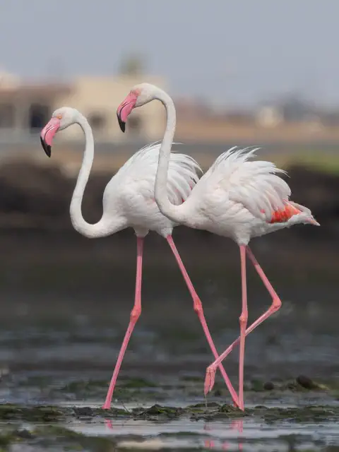
Greater flamingo
The greater flamingo is the tallest and heaviest flamingo, standing up to about 1.45 meters tall. It lives in salty lagoons and lakes across Africa, southern Europe, the Middle East and South Asia. It feeds by holding its bent bill upside down in the water and filtering out tiny animals, and it gets its pink color from what it eats.
-
 Watch
 Country
Democratic Republic of the Congo
The Democratic Republic of the Congo, or DR Congo, is the second-largest country in Africa. The mighty Congo River curves through its rainforests, volcanoes rise in the east, and its capital, Kinshasa, is a center of music, fashion and popular culture.
-
 Watch
 Country
Ethiopia
Ethiopia is a country on the Horn of Africa with no coast. Much of it is high, rugged land cut by the Great Rift Valley, it is one of the world's oldest countries, and more than 110 million people live there.
-
 Watch
 Country
Kenya
Kenya is a country in East Africa, crossed by the equator. It has the snow-capped Mount Kenya, the deep Great Rift Valley, Lake Victoria and a long Indian Ocean coast, and about 54 million people live there, many of them speaking Swahili.
-
 Watch
 Country
Tanzania
Tanzania is a country in East Africa, just south of the Equator, on the Indian Ocean. It has Mount Kilimanjaro, Africa's highest mountain, deep lakes in the East African Rift, and the Serengeti, where huge herds of wildebeest travel each year.
-
 Watch
 Country
Zimbabwe
Zimbabwe is a landlocked country in southern Africa, high on a wide plateau between the Zambezi and Limpopo rivers. It shares Victoria Falls with Zambia, and its name is a Shona word meaning "stone houses", the name of the great stone city of Great Zimbabwe.
-
 Watch
 Country
Egypt
Egypt is in the northeastern corner of Africa, and its Sinai Peninsula reaches into Asia. Almost all of it is desert, so most of its more than 100 million people live along the green banks of the Nile River, where one of the world's earliest civilizations grew.
For parents & teachers
What children will learn
- Locate Tunisia and describe how its land and rainfall change from north to south.
- Describe some of Tunisia's ancient and medieval sites, from Carthage to Kairouan.
- Describe some of Tunisia's languages and foods without treating them as one single culture.
- Outline Tunisia's history from Carthage to independence in 1956.
Recommended ages: 3 to 17 · About 15 minutes
Talk about it
- Why do you think the north of Tunisia is greener than the south?
- People from many places have come to live in Tunisia over thousands of years. What might each group have brought with it?
- An amphitheater held 35,000 people. Where do big crowds gather near you, and what do they come to see?
Try at home or in class
- With a grown-up, roll a pinch of semolina between your palms; UNESCO describes couscous semolina being rolled by hand before it is steamed.
- Draw a strip of paper from north to south and color it from green to tan to show Tunisia's rainy north and dry south.
Key vocabulary: steppe, chott, amphitheater, medina, protectorate, constitution, World Heritage Site
Where these facts come from
- Wikidata , Wikimedia Foundation (CC0 1.0)
- Natural Earth vector data , Natural Earth (NACIS) (Public domain)
- UNESCO World Heritage List , UNESCO World Heritage Centre (Linked as a reference; site facts come from Wikidata)
- Recensement de la population et de l'habitat 2024: la population en Tunisie (infographie) , Institut National de la Statistique (INS), Tunisia
- Diffusion des analyses thématiques du RGPH 2024 (communiqué de presse) , Institut National de la Statistique (INS), Tunisia
- Tunisia , Encyclopaedia Britannica
- Tunisia: Languages (religion, settlement, economy) , Encyclopaedia Britannica
- Tunisia: Daily life and social customs , Encyclopaedia Britannica
- Tunisia: History , Encyclopaedia Britannica
- Tunisia: Domestic development , Encyclopaedia Britannica
- Tunisia: The Jasmine Revolution , Encyclopaedia Britannica
- Tunisia: Unity government , Encyclopaedia Britannica
- Archaeological Site of Carthage , UNESCO World Heritage Centre
- Medina of Tunis , UNESCO World Heritage Centre
- Amphitheatre of El Jem , UNESCO World Heritage Centre
- Dougga / Thugga , UNESCO World Heritage Centre
- Kairouan , UNESCO World Heritage Centre
- Ichkeul National Park , UNESCO World Heritage Centre
- Djerba: Testimony to a settlement pattern in an island territory , UNESCO World Heritage Centre
- Knowledge, know-how and practices pertaining to the production and consumption of couscous , UNESCO Intangible Cultural Heritage
- Harissa, knowledge, skills and culinary and social practices , UNESCO Intangible Cultural Heritage
- PlayOwl region table, version 1 , PlayOwl (PlayOwl original data)
- flag-icons 7.5.0 , Panayiotis Lipiridis and contributors (MIT)
- Wikimedia Commons , Wikimedia Foundation (Per file (public domain, CC0, CC BY or CC BY-SA); see each media record)
Checked, not yet human-reviewed. Last updated October 24, 2026. Spotted a mistake? Tell us.
Picture credits
- Photo: Emna Trabelsi, CC BY-SA 3.0, via Wikimedia Commons · source · license
- Photo: Cimoi, CC BY-SA 3.0, via Wikimedia Commons · source · license
- Photo: Csisc, CC BY-SA 4.0, via Wikimedia Commons · source · license
- Photo: Citizen59 from Tunis, Tunisie, CC BY-SA 2.0, via Wikimedia Commons · source · license
- Photo: weetoon66, CC BY-SA 2.0, via Wikimedia Commons · source · license