
 Country
Africa
Zimbabwe
Zimbabwe is a country in southern Africa. It has a giant waterfall, old stone walls and lots of wild animals.
Zimbabwe is a landlocked country in southern Africa, high on a wide plateau between the Zambezi and Limpopo rivers. It shares Victoria Falls with Zambia, and its name is a Shona word meaning "stone houses", the name of the great stone city of Great Zimbabwe.
Zimbabwe is a landlocked plateau country of southern Africa, almost all of it above 300 m. Its 2022 census counted 15,178,957 people. It became internationally recognized as independent on April 18, 1980, and its name is the Shona word for "stone houses", shared with Great Zimbabwe, a stone city of the 11th to 15th centuries.
Photo: Janice Bell, CC BY-SA 4.0, via Wikimedia Commons
Discover Zimbabwe
Zimbabwe is a country in Africa.
It has no sea coast. Most of the land is high and flat. Big rivers flow along its edges. The capital city is Harare.
Zimbabwe is in southern Africa. It is landlocked, which means it has no coast on the sea. South Africa is to the south, Botswana to the west, Zambia to the north and Mozambique to the east.
Almost all of Zimbabwe is more than 300 meters above sea level. A high ridge called the Highveld runs across the middle of the country, and the land slopes down to the Zambezi River in the north and the Limpopo River in the south. The capital, Harare, is in the northeast.
Zimbabwe is a landlocked country of southern Africa. It shares a 200 km border with South Africa to the south and is bounded by Botswana to the southwest and west, Zambia to the north and Mozambique to the northeast and east. The capital is Harare, formerly Salisbury.
The country lies almost entirely above 300 m. Its spine is the Highveld, a broad ridge about 640 km long and 80 km wide running from southwest to northeast at roughly 1,200 to 1,500 m; it covers about a quarter of the country. On either side the Middleveld, about two-fifths of the area, slopes toward the Zambezi and the Limpopo, and beyond it, mostly in the south, lies the Lowveld. ZimStat's 2022 census counted 15,178,957 people on 390,757 km² of land, an average of 39 people per square kilometer.
Cities and famous places
Great Zimbabwe is a very old stone city.
People built tall stone walls there long ago. One wall makes a giant oval. Harare and Bulawayo are big cities today.
Great Zimbabwe, near the town of Masvingo, is the ruin of a city built between about 1100 and 1450. Its builders, Shona people, made walls of granite blocks. The Great Enclosure, an oval wall from the 1300s, surrounds a narrow passage and a tall cone-shaped tower. It has been a World Heritage Site since 1986.
Today the two main cities are Harare, the capital, and Bulawayo in the southwest. Near Bulawayo are the stone ruins of Khami and the granite Matobo Hills, where people painted on the rocks thousands of years ago.
UNESCO describes Great Zimbabwe (inscribed 1986), about 30 km from Masvingo, as a unique testimony to the Bantu civilization of the Shona between the 11th and 15th centuries. Built between 1100 and 1450 and covering almost 800 ha, it has three groups: the Hill Ruins, continuously inhabited from the 11th to 15th centuries; the Great Enclosure, an ellipse of cut granite blocks laid in regular courses, dating to the 14th century and enclosing living quarters and a high conical tower; and the Valley Ruins. Six soapstone posts topped with birds were found in the Hill Ruins.
Khami (inscribed 1986), 22 km from Bulawayo, developed after Great Zimbabwe was abandoned; Spanish porcelain, Rhineland stoneware and Ming porcelain found there show long-distance trade. The Matobo Hills (inscribed 2003), some 35 km south of Bulawayo, have one of the highest concentrations of rock art in southern Africa, at least 13,000 years old. Britannica calls the Great Enclosure, with an outer wall about 250 m around and up to 11 m high, the largest single ancient structure in sub-Saharan Africa; soapstone bird figures found in the ruins became the Zimbabwe Bird on the national flag.
Plateaus, granite and great rivers
Zimbabwe has round granite hills.
Some rocks balance on top of other rocks. The Zambezi River makes a giant waterfall. A big dam on the river made a huge lake.
Most of Zimbabwe sits on very old granite rock. In the Matobo Hills, wind and water have worn the granite into odd shapes, and some big blocks seem to balance on top of others. Small rounded granite hills, called kopjes, are found all over the country.
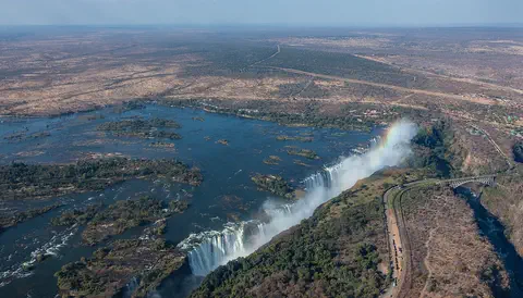
On the Zambezi, Victoria Falls is more than 1.7 kilometers wide. Its spray can be seen from about 50 kilometers away. Farther down the river, Kariba Dam holds back Lake Kariba. The highest point is Mount Nyangani (Inyangani), 2,592 meters, in the eastern highlands.
About four-fifths of Zimbabwe's ancient basement rock is granite; the Matopo (Matobo) Hills south of Bulawayo formed from the long erosion of a granite batholith, leaving balancing rocks and countless kopjes. The Great Dyke, up to about 13 km wide and some 530 km long, crosses the country from north to south; Britannica calls it the longest linear mass of mafic and ultramafic rock in the world, rich in chromium, nickel and platinum. The highest point, Mount Inyangani (Nyangani), reaches 2,592 m in the eastern highlands; the lowest, about 200 m, is near Dumela, where the Limpopo enters Mozambique.
Faulting formed the middle Zambezi trough, now partly flooded by Lake Kariba. UNESCO's Mosi-oa-Tunya/Victoria Falls (inscribed 1989), shared with Zambia, is 1,708 m wide and up to 108 m deep, with up to 500 million liters a minute falling into the first of a zigzag series of eight basalt gorges. Although within the tropics, the high plateau has a subtropical climate. The eastern highlands get the heaviest rain, with a rainy season from October into April that is longer than elsewhere, and the cool, dry winter lasts from May to August.

Animals of Zimbabwe
Zimbabwe has elephants, giraffes and lions.
Hippos and crocodiles live in the big rivers. Big baboons live here too. Many animals live in national parks.
Hwange National Park, in the west, has some of the most crowded remaining wildlife areas in Africa, with many wild animals living close together. Lions, leopards, cheetahs, hyenas and aardvarks live there. Elephants are found in the north, giraffes in the western bushland, and hippos and crocodiles in the larger rivers. There are many antelope too, such as kudu, impala, sable and roan.
Along the Zambezi, Mana Pools National Park is a World Heritage Site. In the dry winter months, huge herds of elephants and buffalo come to its floodplains, and more than 450 kinds of birds have been recorded there.
Britannica describes Hwange National Park, more than 5,000 square miles (about 13,000 km²) stretching from the Bulawayo-Victoria Falls railway to the Botswana border, as holding some of the densest remaining wildlife concentrations in Africa, with lion, leopard, cheetah, serval, spotted and brown hyenas, aardvark and pangolin. Elephants live in the north and giraffes in the western bushland; hippopotamuses and crocodiles live in the larger rivers. The chacma baboon is the largest known baboon. Gonarezhou National Park is linked with South Africa's Kruger and Mozambique's Limpopo national parks in the Great Limpopo Transfrontier Park.
UNESCO's Mana Pools National Park, Sapi and Chewore Safari Areas (inscribed 1984) cover 676,600 ha between the Zambezi and an escarpment over 1,000 m high. Huge herds of elephant and buffalo, followed by zebra, waterbuck and their predators, gather on the floodplains each dry winter; the river has sizeable numbers of hippopotamus and Nile crocodile, and over 450 bird species have been recorded. UNESCO notes that the black rhino has disappeared from the site since it was inscribed.
People, languages and food
In 2022, about 15 million people were counted in Zimbabwe.
Many people speak Shona. Others speak Ndebele or other languages. An everyday meal is sadza, made from corn.
About 15 million people were counted in Zimbabwe's 2022 census. More than two-thirds speak Shona as their first language, and about one in six speak Ndebele, mostly around Bulawayo. Zimbabwe's constitution recognizes 16 official languages, including English, Tonga, Venda and sign language.
Sadza, a cooked corn (maize) meal, is a staple food, eaten at least once a day. Corn and tobacco are farmed on the central Highveld, and the drier Lowveld in the south is used for ranching. Some sculptors, such as those of the Tengenenge school, carve hard serpentine stone.
ZimStat's census of 20 April 2022 counted 15,178,957 people, 52 percent of them female, in 3,818,734 households averaging four people; its principal projection is 16,175,966 for 2026. Bantu-speaking groups have lived here for more than ten centuries. More than two-thirds of people speak Shona as a first language and about one in six Ndebele; Ndebele speakers are concentrated around Bulawayo, with Shona-speaking peoples such as the Kalanga, Karanga, Zezuru and Rozwi beyond them. The 2013 constitution gives official status to 16 languages. More than four-fifths of Zimbabweans are Christian. The population is young, with more than a third under 15, and about a third live in towns, mostly Harare and Bulawayo.
HarvestPlus, a CGIAR program, describes sadza, cooked maize meal, as a staple eaten at least once a day; in Shona, the words for lunch and dinner mean 'sadza in the afternoon' and 'sadza in the evening'. Corn and tobacco are farmed intensively on the central spine, while the drier Lowveld is mainly ranching land. Folk traditions survive in dance and pottery, and sculptors of the Tengenenge school carve hard serpentine.
A long history
People have lived in Zimbabwe for a very long time.
Long ago, Shona people built Great Zimbabwe. Later, Britain ruled the land. In 1980, Zimbabwe became an independent country.
Remains of Stone Age peoples show that people lived here as long as 500,000 years ago. The first Bantu-speaking peoples are thought to have arrived between the 400s and the 900s CE, and from the 1100s Shona people built Great Zimbabwe, a trading city of stone. Later, the city of Khami grew near today's Bulawayo.
In the 1830s the Ndebele, who had moved north, set up a kingdom. In 1890 settlers sent by a British company arrived; the company came to rule the land, which was named Rhodesia in 1895, and the railway reached Bulawayo in 1896 and Victoria Falls in 1904. In 1980 the country became independent as Zimbabwe.
Stone Age remains in Zimbabwe date back about 500,000 years, and the first Bantu-speaking peoples are thought to have arrived between the 5th and 10th centuries CE. Great Zimbabwe was built between 1100 and 1450, and Khami developed after it was abandoned. The Portuguese arrived on the east coast of Africa at the end of the 15th century. In the 1830s the Ndebele, moving north from the south under Mzilikazi, carved out a kingdom.
Cecil Rhodes's British South Africa Company was chartered in 1889; its pioneer column reached the site of the future capital (Salisbury, now Harare) on September 12, 1890, and the territory was named Rhodesia in 1895. Southern Rhodesia became a self-governing British colony in 1923. In 1965 its white-minority government announced a Unilateral Declaration of Independence; conflict with the banned nationalist movements ZAPU and ZANU intensified in the 1970s, and after talks at Lancaster House in London in 1979 and elections in February 1980, Zimbabwe achieved internationally recognized independence on April 18, 1980.

Zimbabwe on the map
Find Zimbabwe on the globe.
It is in the south of Africa. It has no sea coast. Four countries are all around it.
Zimbabwe is in southern Africa, between two big rivers. The land slopes north to the Zambezi River, on the border with Zambia, and south to the Limpopo River, near South Africa. Botswana is to the west and Mozambique to the east.
Zimbabwe has no coast, but its rivers carry water east through Mozambique to the Indian Ocean. Victoria Falls is in the far northwest, and Harare, the capital, is in the northeast.
Zimbabwe lies wholly within the tropics, north of the Tropic of Capricorn, between the Zambezi and Limpopo rivers. It borders South Africa for about 200 km in the south, Botswana to the southwest and west, Zambia to the north and Mozambique to the northeast and east, where the Inyanga Mountains form part of the frontier.
The central Highveld ridge is the main divide between the Zambezi basin and the Limpopo-Sabi basin. Except for a small area of internal drainage in the dry southwest, the Zambezi, Sabi (Save) and Limpopo carry all the country's runoff through Mozambique to the Indian Ocean. Lake Kariba, behind Kariba Dam, lies on the Zambezi along the border with Zambia.
- Highest point
- Mount Inyangani (Nyangani), 2,592 m
- Lowest point
- about 200 m (660 ft), near Dumela on the Limpopo
- Victoria Falls width
- 1,708 m
- People (2022 census)
- 15,178,957
Amazing facts
-
The word zimbabwe means stone houses.
The word zimbabwe is Shona for "stone houses". Great Zimbabwe, a stone city built between about 1100 and 1450, has the same name.
Britannica explains that zimbabwe, the country's namesake, is a Shona word meaning stone houses, and that Great Zimbabwe's Great Enclosure has an outer wall about 250 m around and up to 11 m high.
-
The spray from Victoria Falls can be seen from far away.
The spray from Victoria Falls can be seen from about 50 kilometers away on the road from Bulawayo.
UNESCO reports a spray plume up to about 500 m high, visible from about 50 km away on the Bulawayo road and 30 km away on the Lusaka road in Zambia.
-
Some rocks in Zimbabwe balance on other rocks.
In the Matobo Hills, wind and water have worn granite into balancing rocks that look as if they could tip over.
The Matopo (Matobo) Hills formed from prolonged erosion of an exposed granite batholith; some hills are topped by balancing rocks eroded along regular fault lines.
-
Zimbabwe has 16 official languages.
Zimbabwe's constitution names 16 official languages, including Shona, Ndebele, English and sign language.
The 2013 constitution gives official status to Chewa, Chibarwe, English, Kalanga, Khoisan, Nambya, Ndau, Ndebele, Shangaan, Shona, sign language, Sotho, Tonga, Tswana, Venda and Xhosa.
-
In Shona, lunch and dinner are named after sadza.
Sadza, a cooked corn meal, is so important that in Shona the words for lunch and dinner mean 'sadza in the afternoon' and 'sadza in the evening'.
HarvestPlus notes that sadza is eaten at least once a day and that the Shona terms for lunch and dinner literally mean 'sadza in the afternoon' and 'sadza in the evening'.
Words to know
- landlocked
- having no coast on the sea or ocean
- plateau
- a wide area of high, fairly flat land
- granite
- a hard, speckled rock that forms from melted rock cooling slowly underground
- kopje
- a small, rounded rocky hill rising from flat land
- gorge
- a deep, narrow valley with steep rocky sides
- reservoir
- a lake made by building a dam across a river
- census
- an official count of all the people in a country
Discovery challenge
-
Which giant waterfall is on Zimbabwe's border?
Which waterfall does Zimbabwe share with Zambia?
Which waterfall, 1,708 m wide on the Zambezi, does Zimbabwe share with Zambia?
- Niagara Falls
- Victoria Falls
- Angel Falls
Show the answer
Victoria Falls
Victoria Falls is on the Zambezi River, between Zimbabwe and Zambia.
Victoria Falls is on the Zambezi, shared by Zimbabwe and Zambia, and its spray can be seen from about 50 kilometers away.
Mosi-oa-Tunya/Victoria Falls, inscribed by UNESCO in 1989, is 1,708 m wide and up to 108 m deep.
-
The old city of Great Zimbabwe is made of what?
Great Zimbabwe, whose name means stone houses, was a city built of what?
The Great Enclosure at Great Zimbabwe is built of cut blocks of which material?
- Stone
- Ice
- Glass
Show the answer
Stone
Great Zimbabwe was built of stone, long ago.
Shona people built Great Zimbabwe's huge walls from granite blocks between about 1100 and 1450.
UNESCO describes the 14th-century Great Enclosure as built of cut granite blocks laid in regular courses.
-
Does Zimbabwe have a beach on the sea?
Zimbabwe is landlocked. Does it have a sea coast?
Zimbabwe's rivers reach the Indian Ocean only through Mozambique. Does Zimbabwe have a coast of its own?
- No, it has no sea coast
- Yes, it is an island
- Yes, it is on the Atlantic
Show the answer
No, it has no sea coast
Zimbabwe has no sea coast. Land is all around it.
Landlocked means it has no coast; Zambia, Mozambique, South Africa and Botswana surround it.
Zimbabwe is landlocked; the Zambezi, Sabi and Limpopo carry its runoff through Mozambique to the Indian Ocean.
-
Sadza is made from which food?
Sadza, a staple food in Zimbabwe, is made from which crop?
Sadza, eaten at least once a day in Zimbabwe, is a cooked meal of which grain?
- Rice
- Corn (maize)
- Potatoes
Show the answer
Corn (maize)
Sadza is made from corn.
Sadza is a cooked maize (corn) meal, and corn is grown on the central Highveld.
HarvestPlus describes sadza as cooked maize meal, a staple eaten at least once a day.
-
In which year did Zimbabwe become a free country?
In which year did Zimbabwe become independent?
In which year did Zimbabwe achieve internationally recognized independence?
- 1890
- 1965
- 1980
Show the answer
1980
Zimbabwe became independent in 1980.
Zimbabwe became an independent country in April 1980.
Internationally recognized independence came on April 18, 1980, with Robert Mugabe as the first prime minister.
Places to discover in Zimbabwe
Animals of Zimbabwe
Explore next
-
Watch
Natural wonder
Victoria Falls
Victoria Falls, on the Zambezi River between Zambia and Zimbabwe, is about 1,708 meters wide and up to 108 meters deep. UNESCO calls it the largest curtain of falling water in the world, and its spray can be seen from tens of kilometers away.
-
 Watch
Animal
Common hippopotamus
The common hippopotamus is one of the biggest animals on land, yet it spends most of the day resting in rivers and lakes to keep cool. At night it walks out to graze, and its special skin makes its own sunscreen.
-
 Watch
 Country
Democratic Republic of the Congo
The Democratic Republic of the Congo, or DR Congo, is the second-largest country in Africa. The mighty Congo River curves through its rainforests, volcanoes rise in the east, and its capital, Kinshasa, is a center of music, fashion and popular culture.
-
 Watch
 Country
Ethiopia
Ethiopia is a country on the Horn of Africa with no coast. Much of it is high, rugged land cut by the Great Rift Valley, it is one of the world's oldest countries, and more than 110 million people live there.
-
 Watch
 Country
Kenya
Kenya is a country in East Africa, crossed by the equator. It has the snow-capped Mount Kenya, the deep Great Rift Valley, Lake Victoria and a long Indian Ocean coast, and about 54 million people live there, many of them speaking Swahili.
-
 Watch
 Country
Tanzania
Tanzania is a country in East Africa, just south of the Equator, on the Indian Ocean. It has Mount Kilimanjaro, Africa's highest mountain, deep lakes in the East African Rift, and the Serengeti, where huge herds of wildebeest travel each year.
-
 Watch
 Country
Egypt
Egypt is in the northeastern corner of Africa, and its Sinai Peninsula reaches into Asia. Almost all of it is desert, so most of its more than 100 million people live along the green banks of the Nile River, where one of the world's earliest civilizations grew.
-
 Watch
 Country
Algeria
Algeria is a country in North Africa and the largest country on the whole continent. More than four-fifths of it is the Sahara Desert, so most of its 47 million people (2025) live in the greener north, along the Mediterranean Sea. Its capital is Algiers.
For parents & teachers
What children will learn
- Locate Zimbabwe, name its four neighbors and explain what landlocked means.
- Describe the Highveld plateau, granite hills and the Zambezi with Victoria Falls and Lake Kariba.
- Explain why Great Zimbabwe matters and how the country got its name.
- Outline Zimbabwe's history from Great Zimbabwe to independence in 1980.
Recommended ages: 3 to 17 · About 15 minutes
Talk about it
- How might a country with no coast get goods from other parts of the world?
- Great Zimbabwe's stone walls were built without mortar. How do you think the builders made them stand so tall?
- Zimbabwe has 16 official languages. How many languages do people speak in your town?
Try at home or in class
- Stack small stones or blocks into a curved wall without glue, as the builders of Great Zimbabwe did with granite, and see how tall it can go.
- On a map of Africa, trace the Zambezi and the Limpopo and color Zimbabwe between them.
Key vocabulary: landlocked, plateau, granite, kopje, gorge, reservoir, census
Where these facts come from
- Wikidata , Wikimedia Foundation (CC0 1.0)
- Natural Earth vector data , Natural Earth (NACIS) (Public domain)
- UNESCO World Heritage List , UNESCO World Heritage Centre (Linked as a reference; site facts come from Wikidata)
- Zimbabwe 2022 Population and Housing Census Report , Zimbabwe National Statistics Agency (ZIMSTAT)
- 2022 Population Projection Report (Table 3.1) , Zimbabwe National Statistics Agency (ZIMSTAT)
- Nyanga National Park (Mt. Nyangani, the highest point in Zimbabwe) , Zimbabwe Parks and Wildlife Management Authority
- Zimbabwe (introduction, relief, drainage, soils) , Encyclopaedia Britannica
- Zimbabwe: Climate (plant and animal life, settlement, people) , Encyclopaedia Britannica
- Zimbabwe: Cultural life (and early history) , Encyclopaedia Britannica
- Zimbabwe: The British South Africa Company , Encyclopaedia Britannica
- Great Zimbabwe , Encyclopaedia Britannica
- Zimbabwe: Rhodesia and the UDI , Encyclopaedia Britannica
- Great Zimbabwe National Monument , UNESCO World Heritage Centre
- Khami Ruins National Monument , UNESCO World Heritage Centre
- Matobo Hills , UNESCO World Heritage Centre
- Mosi-oa-Tunya / Victoria Falls , UNESCO World Heritage Centre
- Mana Pools National Park, Sapi and Chewore Safari Areas , UNESCO World Heritage Centre
- Sadza is more than sustenance: Zimbabweans embrace orange maize , HarvestPlus (CGIAR, International Food Policy Research Institute)
- PlayOwl region table, version 1 , PlayOwl (PlayOwl original data)
- flag-icons 7.5.0 , Panayiotis Lipiridis and contributors (MIT)
- Wikimedia Commons , Wikimedia Foundation (Per file (public domain, CC0, CC BY or CC BY-SA); see each media record)
Checked, not yet human-reviewed. Last updated October 24, 2026. Spotted a mistake? Tell us.
Picture credits
- Photo: Janice Bell, CC BY-SA 4.0, via Wikimedia Commons · source · license
- Photo: Diego Delso, CC BY-SA 4.0, via Wikimedia Commons · source · license
- Photo: Rhys Jones, CC BY 2.0, via Wikimedia Commons · source · license
- Photo: MaltaGC (Nigel Tout), CC BY-SA 4.0, via Wikimedia Commons · source · license