
City Asia
Bursa
Bursa is a city in Türkiye, at the foot of a tall mountain called Uludağ. Cars and silk cloth are made there.
Bursa is a city in western Türkiye, 91 kilometers south of Istanbul and 20 kilometers from the Sea of Marmara, at the foot of the mountain Uludağ. Store norske leksikon calls it Türkiye's largest center for making cars and car parts. Türkiye's official estimate for the city at the end of 2022 was 2,051,464 people.
Bursa, western Türkiye, 91 km south of Istanbul, 20 km from the Sea of Marmara, at the foot of Uludağ (2,543 m); the country's largest center of car and car-parts production, with a large textile industry (Store norske leksikon); the first capital of the Ottoman Empire (1326–1365). City: 2,051,464 (register-based estimate, 31 December 2022); 1,194,687 (census 2000) (TurkStat, via City Population).
Photo: Karelj, CC BY-SA 3.0, via Wikimedia Commons
Discover Bursa
Bursa is a big city in Türkiye.
It sits at the foot of a tall mountain called Uludağ, not far from the sea.
Bursa lies in western Türkiye, 91 kilometers south of Istanbul and 20 kilometers from the Sea of Marmara. Store norske leksikon, Norway's big encyclopedia, says it stands at the foot of Uludağ, a mountain 2,543 meters high.
Türkiye's official estimate for the city at the end of 2022 was 2,051,464 people, and for the whole province of Bursa 3,194,720. At the census of 2000, the city had 1,194,687.
Store norske leksikon ('Bursa – by i Tyrkia', Sten Lundbo, updated 20 March 2026): a city in western Türkiye, 91 km south of Istanbul, 20 km from the Sea of Marmara, at the foot of the 2,543 m mountain Uludağ; the province 3,194,720 inhabitants (2022). City Population ('Turkey: Provinces and Major Cities', TurkStat; city figures from censuses and register-based tabulations): Bursa city 612,510 (census 1985), 834,576 (census 1990), 1,194,687 (census 2000), 1,704,441 (estimate 2011), 1,899,479 (estimate 2017), 2,051,464 (estimate 31 December 2022), fourth on its list of major cities; Bursa province 3,194,720 (estimate 2022).
- Where
- western Türkiye, 91 km south of Istanbul, 20 km from the Sea of Marmara, at the foot of Uludağ (Store norske leksikon)
- People in the city (estimate, end of 2022)
- 2,051,464
- Bursa province (estimate, end of 2022)
- 3,194,720 (City Population)
Red roofs across the plain
Look at all the red roofs and tall buildings!
Trees grow in front, and far-off mountains rise under a deep blue sky.
The photographer Karelj took this view of the central part of Bursa on 24 August 2013. Red-roofed blocks and tall apartment towers spread across a wide plain, and a curving road runs below. Trees grow in front, and far-off mountains rise under a deep blue sky with white clouds.
On Wikidata, Koza Han, a caravanserai where traders once stayed, is about 1.6 kilometers west-southwest of the city's point, and the Irgandı Bridge, a covered arch bridge, about 1.3 kilometers southwest.
Commons: File:Bursa Turkey panorama 2013 1.jpg, own work by Karelj (CC BY-SA 3.0 and GFDL), taken 24 August 2013, uploaded 24 October 2013 (3,000 by 2,000 pixels); description 'View on central part of Bursa city in Turkey'; camera location 40.1876° N, 29.0577° E, about 2.0 km WSW of the city's point. Seen in the 1,280-pixel copy: red-roofed blocks and apartment towers across a plain, a curving road with a few small cars, trees and a slope in front, far mountains, a deep blue sky with white clouds. Wikidata from the city point (Q40738): Irgandı Bridge (Q6026873; covered bridge, arch bridge) 1.33 km SW; Koza Han (Q6055245, caravanserai) 1.64 km WSW.
- In the photo
- a view over the central part of Bursa, 24 August 2013 (Karelj)
- Koza Han
- a caravanserai, an old inn for traders, about 1.6 km west-southwest of the city's point (Wikidata)
- Irgandı Bridge
- a covered arch bridge, about 1.3 km southwest of the city's point (Wikidata)
The first Ottoman capital
Long ago, Bursa was the first capital of an empire, the Ottoman Empire.
Today, Bursa and a village nearby are on UNESCO's World Heritage List.
Store norske leksikon says that from 1326 to 1365 Bursa was the first capital of the Ottoman Empire and the home of the Ottoman sultans. Because of this, Bursa and the nearby village of Cumalıkızık were put on UNESCO's World Heritage List in 2014.
The city has grown fast. City Population's table gives 612,510 people at the 1985 census, 1,194,687 at the 2000 census and 2,051,464 at the end of 2022.
Store norske leksikon: in 1326–1365 Bursa was the first capital of the Ottoman Empire and the residence of the Ottoman sultans; for this reason Bursa and the nearby village of Cumalıkızık were inscribed on UNESCO's World Heritage List in 2014 ('Bursa and Cumalıkızık – the Birth of the Ottoman Empire'). City Population (TurkStat): 612,510 (census 20 October 1985), 834,576 (21 October 1990), 1,194,687 (22 October 2000), 1,704,441 (estimate 2011), 1,899,479 (estimate 2017), 2,051,464 (estimate 31 December 2022).
- 1326–1365
- the first capital of the Ottoman Empire (Store norske leksikon)
- World Heritage
- Bursa and the nearby village of Cumalıkızık, listed in 2014 (Store norske leksikon)
- 1985 census
- 612,510 people in the city (City Population)
Metro, rail and a ski mountain
People ski on the mountain near Bursa.
The city has a metro, and a railway runs to the port town of Mudanya.
Store norske leksikon says there is an airport 32 kilometers from Bursa and a railway to the port town of Mudanya. The Uludağ ski center, 35 kilometers southeast of the city, draws many tourists.
On Wikidata, the Gökdere metro station is about 0.3 kilometers south-southwest of the city's point, and the summit of Uludağ about 18 kilometers southeast.
Store norske leksikon: an airport 32 km from Bursa; a railway to the port town of Mudanya; the Uludağ ski center 35 km southeast of Bursa, with many tourists. Wikidata from the city point: Gökdere metro station (Q61074967) 0.34 km SSW; Uludağ (Q925688, mountain, 2,542 m on Wikidata) 18.03 km SE.
- Airport
- 32 km from Bursa (Store norske leksikon)
- Railway
- a line to the port town of Mudanya (Store norske leksikon)
- Uludağ ski center
- 35 km southeast of Bursa, with many tourists (Store norske leksikon)
Hot summers, wet winters
Summers in Bursa are hot and dry.
Winters are cool, and December brings the most rain.
The German Weather Service's climate table for Bursa, for 1961 to 1990, shows average highs of 30.3 °C in July and 9.3 °C in January. January nights average 1.4 °C.
About 706 millimeters of rain fall in a year. December is the wettest month, with 118.4 millimeters, and July the driest, with 16.4.
Deutscher Wetterdienst, Klimatafel von Bursa / Türkei (station at 40° 11' N, 29° 04' E, 100 m; period 1961-1990 as given in the table): mean daily maximum 9.3 °C (Jan) to 30.3 °C (Jul); mean daily minimum 1.4 °C (Jan) to 16.5 °C (Jul); daily mean 5.2 to 24.1 °C, year 14.4 °C. Precipitation 89.6, 85.8, 64.0, 62.2, 45.5, 29.9, 16.4, 20.3, 35.4, 58.0, 80.6, 118.4 mm (Jan-Dec); year 706.1 mm (= the month sum); 80 days with at least 1.0 mm.
- July, average daily high (DWD, Bursa, 1961–1990)
- 30.3 °C, the warmest month
- Wettest and driest months (same table)
- December, 118.4 mm; July, 16.4 mm
- Rain in a year (same table)
- 706.1 mm
Cars, silk and hot springs
Cars are made in Bursa, and so is cloth from silk, wool and cotton.
Warm water flows from springs near the city.
Store norske leksikon says Bursa is Türkiye's largest center for making cars and car parts. The city also has a large textile industry using silk, wool and cotton, as well as machine and food industries.
Near the city there are warm mineral springs with sulfur and iron in the water, and Bursa has several old Turkish baths. It has two public universities, the oldest founded in 1975. On Wikidata, the Bursa City Museum is about 1.6 kilometers southwest of the city's point.
Store norske leksikon: Türkiye's largest center for the production of cars and car parts for several international makers; a large textile industry with silk, wool and cotton, plus machinery and food industry; warm mineral springs containing sulfur and iron nearby; several old Turkish baths; two public universities, the oldest founded in 1975. Wikidata from the city point: Baths of Demirtaş Paşa (Q131738464, public baths) 0.87 km WSW; Bursa City Museum (Q6040943) 1.55 km SW.
- Industry
- Türkiye's largest center for cars and car parts; textiles of silk, wool and cotton; machinery and food (Store norske leksikon)
- Hot springs
- warm mineral springs with sulfur and iron nearby; several old Turkish baths in the city (Store norske leksikon)
- Universities
- two public universities; the oldest founded in 1975 (Store norske leksikon)
Bursa on the map
Find Türkiye on the globe. Look south of the Sea of Marmara, near Istanbul. There is Bursa!
Bursa lies at about 40.19° north and 29.08° east, 91 kilometers south of Istanbul and 20 kilometers from the Sea of Marmara.
On Wikidata, the metro station is about 0.3 kilometers from the city's point, the Irgandı Bridge about 1.3 kilometers, the City Museum about 1.6 kilometers, Koza Han about 1.6 kilometers and the summit of Uludağ about 18 kilometers.
Bursa lies at about 40.19° N, 29.08° E (Wikidata point of Bursa, Q40738); 91 km south of Istanbul, 20 km from the Sea of Marmara (Store norske leksikon). Wikidata from the city point: Gökdere metro station 0.34 km SSW; Baths of Demirtaş Paşa 0.87 km WSW; Irgandı Bridge 1.33 km SW; Bursa City Museum 1.55 km SW; Koza Han 1.64 km WSW; Uludağ 18.03 km SE.
- Latitude
- about 40.19° north
- Longitude
- about 29.08° east
- Istanbul
- 91 km to the north (Store norske leksikon)
Amazing facts
-
People can ski on the mountain near Bursa!
Store norske leksikon says the Uludağ ski center, 35 kilometers southeast of Bursa, draws many tourists.
Store norske leksikon: Uludağ ski center 35 km southeast of Bursa, with many tourists.
-
Warm water with minerals comes out of the ground near Bursa!
Store norske leksikon says there are warm mineral springs near Bursa, with sulfur and iron in the water.
Store norske leksikon: warm mineral springs containing sulfur and iron nearby; several old Turkish baths in the city.
-
Bursa was the first capital of the Ottoman Empire!
Store norske leksikon says Bursa was the first capital of the Ottoman Empire, from 1326 to 1365.
Store norske leksikon: in 1326–1365 the first capital of the Ottoman Empire and the residence of its sultans.
Words to know
- caravanserai
- an old inn with a courtyard where traders and their animals stayed
- mineral spring
- a place where water with minerals in it flows out of the ground
- empire
- a group of lands ruled by one ruler or government
- textile
- cloth, or the work of making cloth
- estimate
- a careful official figure worked out from records, not a full count
- census
- an official count of all the people living in a place
Discovery challenge
-
Bursa is a city in which country?
Bursa, 91 kilometers south of Istanbul, is in which country?
Bursa, at the foot of Uludağ near the Sea of Marmara, is in which country?
- Türkiye
- Greece
- Egypt
Show the answer
Türkiye
Türkiye!
Türkiye.
Türkiye.
-
What is made in Bursa's factories?
Store norske leksikon calls Bursa Türkiye's largest center for making what?
For which product is Bursa Türkiye's largest production center, according to Store norske leksikon?
- Cars
- Ships
- Airplanes
Show the answer
Cars
Cars!
Cars and car parts.
Cars and car parts.
-
What is the tall mountain near Bursa called?
Bursa lies at the foot of which mountain, 2,543 meters high?
Which 2,543 m mountain rises above Bursa, according to Store norske leksikon?
- Uludağ
- Erciyes
- Mont Blanc
Show the answer
Uludağ
Uludağ!
Uludağ.
Uludağ.
-
Which month brings the most rain to Bursa?
In the German Weather Service's 1961-1990 table, which is Bursa's wettest month?
Which month has the highest precipitation in DWD's 1961-1990 climate table for Bursa?
- December
- July
- August
Show the answer
December
December!
December, with 118.4 millimeters.
December, 118.4 mm.
Nearby places
-
 Watch
Landmark
Sultan Ahmed Mosque
The Sultan Ahmed Mosque in Istanbul was built between 1609 and about 1616 for the Ottoman ruler Sultan Ahmed I. Its central dome is ringed by half-domes and smaller domes, and six slender minarets rise around it. Many people call it the Blue Mosque because of the blue and green tiles and painted decoration inside. It is still a working mosque, where Muslims come to pray.
-
 Watch
Landmark
Hagia Sophia
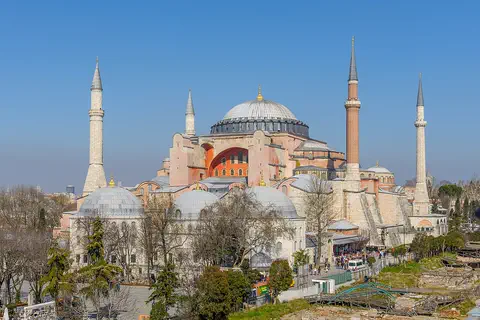
Hagia Sophia in Istanbul was built in under six years, from 532 to 537, for the emperor Justinian. Its enormous dome seems to float on a ring of 40 windows. Over almost 1,500 years it has been a church, a mosque and a museum, and since 2020 it has been a mosque.
-
 Watch
Landmark
Topkapı Palace
Topkapı Palace sits on a point of land where the Bosphorus Strait meets the sea in Istanbul. Sultan Mehmed II built it between 1460 and 1478, and for nearly 400 years it was the home of the Ottoman sultans and the center of their government. In 1924 it became a museum.
-
 Watch
Landmark
Süleymaniye Mosque
The Süleymaniye Mosque in Istanbul, Türkiye, was designed by the architect Sinan and built between 1550 and 1557 for the Ottoman sultan Süleyman. With the mosque, Sinan built a whole complex of schools, a hospital, an inn for travelers, a kitchen and a bath. It is part of the Historic Areas of Istanbul, a UNESCO World Heritage Site since 1985.
-
 Watch
Landmark
Aqueduct of Valens
The Aqueduct of Valens is a bridge of arches in Istanbul, Türkiye, 971 meters long with 86 arches. It carried a water channel across a valley between two hills. It is named after the emperor Valens, and a research project at Radboud University dates its construction to 368 to 373.
-
 Watch
City
Istanbul
Istanbul is the biggest city in Türkiye, built on both sides of the Bosporus, the narrow strait between Europe and Asia. Once called Byzantium and then Constantinople, it was the capital of two great empires. About 15.7 million people lived in Istanbul province in 2023.
-
 Watch
Natural wonder
Sea of Marmara
The Sea of Marmara is a small inland sea between the Black Sea and the Aegean Sea, joined to them by two narrow straits. A big fault runs across its floor, and its water comes in two layers: less salty water from the Black Sea on top, and saltier Mediterranean water below.
-
 Watch
Landmark
Pergamon
Pergamon is an ancient city in western Türkiye, built on a steep hill above the Bakırçay Plain. It was the capital of the Attalid kings from the 3rd century BC and later of a Roman province. UNESCO says its kings founded one of the largest libraries, and it is a UNESCO World Heritage Site.
Explore next
-
 Watch
 Country
Türkiye (Turkey)
Türkiye, also called Turkey, lies partly in Asia and partly in Europe. A narrow waterway called the Bosporus runs through its biggest city, Istanbul, and its land is mostly mountains and high plains. About 86 million people live there.
-
Watch
City
Istanbul
Istanbul is the biggest city in Türkiye, built on both sides of the Bosporus, the narrow strait between Europe and Asia. Once called Byzantium and then Constantinople, it was the capital of two great empires. About 15.7 million people lived in Istanbul province in 2023.
-
 Watch
City
İzmir
İzmir, once called Smyrna, is Türkiye's third-biggest city, with 2,948,160 people in the city at the end of 2022. It wraps around the inner end of the Gulf of İzmir on the Aegean coast, and it is the country's second port after Istanbul.
-
 Watch
City
Adana
Adana is a city in southern Türkiye on the Seyhan River. Store norske leksikon calls it an industrial city and an important center of Türkiye's cotton industry, on the railway from Istanbul. Türkiye's official estimate for the city at the end of 2022 was 1,779,463 people.
-
 Watch
City
Abu Dhabi
Abu Dhabi is the capital of the United Arab Emirates. It began in the 1700s as a small settlement around fresh water on an island, guarded by a coral-stone watchtower. Before oil, it relied on fishing and pearl diving; since the 1960s, money from oil has turned it into a city of towers. An official estimate gave the city about 1.75 million people in 2023.
-
 Watch
City
Almaty
Almaty is the main city of Kazakhstan, in the southeast of the country at the foot of the Ala-Tau mountains. It was founded in 1854 where a Kazakh village called Almaty, 'village of apple trees', stood. It was the capital until 1998, and about 2,387,900 people lived there on 1 September 2026.
-
 Watch
City
Amman
Amman is the capital of Jordan, built on steep hills around a valley high on a plateau. Long ago it was a Roman city called Philadelphia, and its Roman theater, carved into a hillside, still holds about 6,000 people. Today the city spreads across the hills, with houses faced in pale stone. About 4.6 million people lived in Amman Governorate at the end of 2021.
-
 Watch
City
Ankara
Ankara is the capital of Türkiye, in the interior of Anatolia, about 200 kilometers from the Black Sea. People have lived here since the Stone Age, and Romans, Byzantines, Seljuks and Ottomans all left buildings behind. It became the capital in 1923, and today it is a city of government, universities and museums.
For parents & teachers
What children will learn
- Locate Bursa south of Istanbul and the Sea of Marmara.
- Read a climate table and compare a dry summer with a wet winter.
- Explain how a mountain nearby can bring visitors, springs and skiing.
- Tell a census figure from an official estimate.
Recommended ages: 3 to 17 · About 15 minutes
Talk about it
- Why might traders have needed inns like Koza Han long ago?
- How might a car industry change a city's size?
- Why do you think warm water comes out of the ground near some mountains?
Try at home or in class
- Rain bars: draw a bar for each month of Bursa's rain and color the dry summer months.
- Silk look: with a grown-up, compare a piece of silk, wool and cotton cloth by touch and by holding them to the light.
- Mountain city: fold a tall paper mountain and stand small paper buildings at its foot.
Key vocabulary: caravanserai, mineral spring, empire, textile, estimate, census
Where these facts come from
- Wikidata , Wikimedia Foundation (CC0 1.0)
- Natural Earth vector data , Natural Earth (NACIS) (Public domain)
- Bursa – by i Tyrkia , Store norske leksikon
- Turkey: Provinces and Major Cities , City Population (Thomas Brinkhoff), from the Turkish Statistical Institute
- Klimatafel von Bursa / Türkei , Deutscher Wetterdienst
- File:Bursa Turkey panorama 2013 1.jpg , Wikimedia Commons
- Wikimedia Commons , Wikimedia Foundation (Per file (public domain, CC0, CC BY or CC BY-SA); see each media record)
Checked, not yet human-reviewed. Last updated November 2, 2026. Spotted a mistake? Tell us.