
Natural wonder Asia
Sea of Marmara
The Sea of Marmara is a small sea between two other seas. Light, less salty water floats on top of heavy, salty water. Dolphins swim there.
The Sea of Marmara is a small inland sea between the Black Sea and the Aegean Sea, joined to them by two narrow straits. A big fault runs across its floor, and its water comes in two layers: less salty water from the Black Sea on top, and saltier Mediterranean water below.
The Sea of Marmara, about 280 km long and 80 km wide, sits on the North Anatolian Fault, the boundary between the Eurasian and Anatolian plates, and holds three basins about 1,250 m deep. A two-way exchange through the Bosporus and Dardanelles straits keeps brackish Black Sea water above saltier Mediterranean water.
Photo: AlexTheToaster, CC BY-SA 4.0, via Wikimedia Commons
Discover the Sea of Marmara
The Sea of Marmara is a small sea. It lies between the Black Sea and the Aegean Sea.
In this photo, the sun shines over the water. Small boats float on the calm sea.
The Sea of Marmara is a small inland sea. Two narrow straits join it to other seas: the Bosporus to the Black Sea, and the Dardanelles toward the Aegean and the Mediterranean. Turkey surrounds it on all sides, NASA notes.
The photographer called this picture a sunrise on the Sea of Marmara. The sun glows behind low hills on the far shore, small boats sit on the shining water, and leaves frame the view.
Researchers describe the Sea of Marmara as a sea about 280 km long and 80 km wide between the Mediterranean and the Black Sea, connected through the Dardanelles (Çanakkale) and Bosporus (Istanbul) straits, whose shallowest points, or sills, are 65 m and 35 m deep. Its floor has shelves 90 to 100 m deep and three basins about 1,250 m deep.
The hero photo, by AlexTheToaster, was shared on Wikimedia Commons for Wiki Loves Earth 2023 and is titled a sunrise on the Sea of Marmara: the sun behind low hills on a distant shore, small boats on bright water, and leaves framing the scene.
- Size
- about 280 km long and 80 km wide
- Deep basins
- three, each about 1,250 m deep
- Joined to other seas by
- the Bosporus and Dardanelles straits
- Surface water
- about two thirds as salty as the ocean (NASA)
A sea on a moving fault
Deep under the sea, a giant crack runs through the rock. It is called a fault.
The ground on each side slowly slides past the other. Deep holes formed in the sea floor along it.
The Sea of Marmara sits on the North Anatolian Fault, a crack where two plates of Earth's crust, the Eurasian plate and the Anatolian plate, slide sideways past each other. Its most active branch cuts across the sea floor from east to west.
Along this fault, three deep basins, each about 1,250 meters deep, have formed between higher ridges. Their steep sides are marked by underwater canyons and the scars of landslides. Strong earthquakes have happened along the fault in the past, so scientists study the layers of mud on the sea floor to learn its history.
Çağatay and colleagues describe the sea as lying on a major continental transform boundary, the North Anatolian Fault. Around the sea the fault splits into branches across a zone about 100 km wide; the most active, the Main Marmara Fault, cuts the floor east to west and takes about 75% of the roughly 24 mm a year of right-lateral motion between the Eurasian and Anatolian plates.
The deep subbasins are described as transtensional and hold 5 to 6 km of sediment. Slopes up to 29 degrees on the north side carry submarine canyons and landslide scars. Layers of mud shaken loose by past earthquakes record the fault's history, which the team traced back more than 5,000 years.
Two seas in one
Long ago, this sea was a lake. Then sea water flowed back in.
Now light, less salty water floats on top. Heavy, salty water stays below.
During the last ice age, the Sea of Marmara was a lake of fresh to slightly salty water. About 12,550 years ago, it became a sea again.
Today, water flows both ways through the straits. Less salty water from the Black Sea runs along the top, while saltier water from the Mediterranean flows in underneath. A lasting boundary between the two layers sits about 25 meters below the surface. Rivers from the south add more fresh water.
The sea was a fresh to brackish lake during the last glacial period; marine conditions returned about 12,550 years ago (dated 12.55 ka BP), and before that the lake level was set mainly by the Dardanelles sill, about 85 m deep just before the reconnection.
Today a two-way exchange carries Black Sea water of about 18 psu (practical salinity units) in the upper current and Mediterranean water of about 38.5 psu in the lower current, with a permanent pycnocline at about 25 m. A 35-year computer model (1987 to 2021) by Saçu, Şen and Erdik found a strong westward flow in the central basin and a statistically significant decline in the upper-layer flow, linked to a shrinking sea-level difference between the Black Sea and the Aegean, potentially driven by more evaporation from the Black Sea.
Plankton swirls and dolphins
Tiny living things called plankton float in the sea. Sometimes so many grow that the water changes color.
Dolphins and porpoises swim in the Sea of Marmara too.
NASA calls the Sea of Marmara a rich soup of nutrients and life. Its fresher surface water and nutrients from rivers help tiny floating organisms called phytoplankton grow. In May 2015, a satellite photographed swirls of them. Scientists found mostly two kinds of dinoflagellates, Prorocentrum micans and Noctiluca scintillans, which can change the color of the water.
Bigger animals live here too. In April 2015, Istanbul University scientists watched a young harbour porpoise swimming with a group of bottlenose dolphins in the Marmara Sea.
NASA's Earth Observatory describes a phytoplankton bloom imaged by Landsat 8 on 17 May 2015: swirling filaments that trace eddies and currents, driven by water rushing through the straits, a jagged coastline and a tectonically fractured sea floor. Sampling by Baris Salihoglu and Ahsen Yuksek showed mostly Prorocentrum micans and Noctiluca scintillans; Prorocentrum bloomed first and Noctiluca later dominated. Noctiluca can eat other phytoplankton.
Tonay, Dede and Amaha Öztürk (2017) reported a juvenile harbour porpoise in a non-aggressive interaction with bottlenose dolphins in the Marmara Sea on 25 April 2015. Mucilage, a slimy material, has also formed in the sea: Doğan and colleagues sampled mucilaginous aggregates at six sites during an event from autumn 2021 to summer 2022 and found a wide range of plankton in them.
Visiting safely
If you see dolphins, watch them from far away. Never feed them.
Swim only with a grown-up. If water pulls you out, swim along the beach.
NOAA, the United States ocean agency, gives advice that helps anywhere: watch dolphins and porpoises from a safe, respectful distance, never feed them, and never try to touch them or swim with them.
NOAA also warns about rip currents, narrow channels of fast-moving water near the shore. If one catches you, don't fight it. Swim parallel to the shore, then swim back to land at an angle.
NOAA Fisheries advises viewing wild marine mammals from a safe, respectful distance, at least 50 yards (about 46 m) from dolphins and porpoises, never feeding them, and limiting viewing to 30 minutes or less, because a continued presence can stress the animals. These are United States guidelines, but the reasons behind them apply to any sea.
For swimmers, NOAA's National Ocean Service explains that rip currents can move at up to eight feet (about 2.4 m) per second, faster than an Olympic swimmer. Swimmers who fight one by heading straight to shore tire quickly; the advice is to swim parallel to the shore and return at an angle.
Amazing facts
-
This sea was once a lake!
During the last ice age, the Sea of Marmara was a lake. Sea water returned about 12,550 years ago.
The Sea of Marmara was a fresh to brackish lake in the last glacial period; marine conditions were established about 12.55 ka BP (Çağatay et al.).
-
Some tiny sea creatures eat other tiny sea creatures.
Noctiluca, one of the plankton in the 2015 bloom, can eat other phytoplankton.
Noctiluca scintillans is phagotrophic: it eats other phytoplankton, which can change its color (NASA Earth Observatory).
-
The way into the Black Sea is not very deep.
At its shallowest point, the Bosporus strait is only about 35 meters deep.
Sill depths: Bosporus 35 m, Dardanelles 65 m (Çağatay et al.); the sea's basins are about 1,250 m deep.
Words to know
- fault
- a long crack in Earth's crust where the rock on each side moves
- strait
- a narrow channel of water that joins two seas
- basin
- a low, bowl-shaped area, here in the sea floor
- salinity
- how salty water is
- phytoplankton
- tiny plant-like living things that float in water
- mucilage
- a thick, slimy material that can collect in clumps in the sea
Discovery challenge
-
Which water floats on top in the Sea of Marmara?
Which water flows along the top of the Sea of Marmara?
Which water mass forms the upper current in the Sea of Marmara?
- Less salty water from the Black Sea
- Very salty water from the Mediterranean
- Melted ice from glaciers
Show the answer
Less salty water from the Black Sea
Less salty water floats on top.
Less salty Black Sea water flows on top; saltier Mediterranean water flows below.
Black Sea water of about 18 psu forms the upper current.
-
What runs under the sea floor?
Which big fault runs across the floor of the Sea of Marmara?
Which plate boundary does the Main Marmara Fault belong to?
- The North Anatolian Fault
- The Mid-Atlantic Ridge
- The San Andreas Fault
Show the answer
The North Anatolian Fault
A fault called the North Anatolian Fault.
The North Anatolian Fault, where two plates slide past each other.
The North Anatolian Fault, the Eurasian-Anatolian plate boundary.
-
What was this sea a long time ago?
What was the Sea of Marmara during the last ice age?
What was the Sea of Marmara before marine conditions returned about 12.55 ka BP?
- A lake
- A desert
- A glacier
Show the answer
A lake
It was a lake.
A lake of fresh to slightly salty water.
A fresh to brackish lake.
-
Which animals swim in the Sea of Marmara?
Which animals did scientists watch swimming together in the Marmara Sea in 2015?
Which two cetaceans were reported interacting in the Marmara Sea on 25 April 2015?
- Dolphins and a porpoise
- Penguins and seals
- Sharks and whales
Show the answer
Dolphins and a porpoise
Dolphins and a porpoise.
Bottlenose dolphins and a young harbour porpoise.
Bottlenose dolphins and a juvenile harbour porpoise.
-
What should you never do when you see a dolphin?
What does NOAA say you should never do with wild dolphins?
Which action do NOAA's viewing guidelines call harmful and illegal in US waters?
- Feed it
- Watch it from far away
- Stay calm and quiet
Show the answer
Feed it
Never feed a dolphin.
Never feed a dolphin; watch it from a respectful distance.
Feeding wild dolphins.
Nearby places
-
 Watch
Landmark
Aqueduct of Valens
The Aqueduct of Valens is a bridge of arches in Istanbul, Türkiye, 971 meters long with 86 arches. It carried a water channel across a valley between two hills. It is named after the emperor Valens, and a research project at Radboud University dates its construction to 368 to 373.
-
 Watch
Landmark
Süleymaniye Mosque
The Süleymaniye Mosque in Istanbul, Türkiye, was designed by the architect Sinan and built between 1550 and 1557 for the Ottoman sultan Süleyman. With the mosque, Sinan built a whole complex of schools, a hospital, an inn for travelers, a kitchen and a bath. It is part of the Historic Areas of Istanbul, a UNESCO World Heritage Site since 1985.
-
 Watch
Landmark
Sultan Ahmed Mosque
The Sultan Ahmed Mosque in Istanbul was built between 1609 and about 1616 for the Ottoman ruler Sultan Ahmed I. Its central dome is ringed by half-domes and smaller domes, and six slender minarets rise around it. Many people call it the Blue Mosque because of the blue and green tiles and painted decoration inside. It is still a working mosque, where Muslims come to pray.
-
 Watch
Landmark
Hagia Sophia
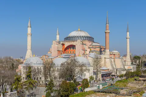
Hagia Sophia in Istanbul was built in under six years, from 532 to 537, for the emperor Justinian. Its enormous dome seems to float on a ring of 40 windows. Over almost 1,500 years it has been a church, a mosque and a museum, and since 2020 it has been a mosque.
-
 Watch
Landmark
Topkapı Palace
Topkapı Palace sits on a point of land where the Bosphorus Strait meets the sea in Istanbul. Sultan Mehmed II built it between 1460 and 1478, and for nearly 400 years it was the home of the Ottoman sultans and the center of their government. In 1924 it became a museum.
-
 Watch
City
Istanbul
Istanbul is the biggest city in Türkiye, built on both sides of the Bosporus, the narrow strait between Europe and Asia. Once called Byzantium and then Constantinople, it was the capital of two great empires. About 15.7 million people lived in Istanbul province in 2023.
-
 Watch
Landmark
Selimiye Mosque
The Selimiye Mosque in Edirne, Türkiye, was built from 1569 to 1575 for the Ottoman sultan Selim II. Its architect, Sinan, called it his masterpiece. A single great dome rests on eight supports, and four minarets about 71 meters tall stand around it. It became a UNESCO World Heritage Site in 2011.
-
 Watch
Landmark
Pergamon
Pergamon is an ancient city in western Türkiye, built on a steep hill above the Bakırçay Plain. It was the capital of the Attalid kings from the 3rd century BC and later of a Roman province. UNESCO says its kings founded one of the largest libraries, and it is a UNESCO World Heritage Site.
Explore next
-
 Watch
Natural wonder
Black Sea
The Black Sea is a large, almost enclosed sea between Europe and Asia. Its water is in layers that hardly mix: the top 150 meters is less salty and has oxygen, while the deep water below has almost no oxygen, so plants and animals cannot live there.
-
 Watch
Natural wonder
Aegean Sea
The Aegean Sea is part of the Mediterranean, between Greece and western Turkey. Its many islands are scattered across about 800 kilometers from north to south. On Santorini, a giant eruption about 3,600 years ago left a caldera hundreds of meters deep, partly flooded by the sea.
-
 Watch
 Country
Türkiye (Turkey)
Türkiye, also called Turkey, lies partly in Asia and partly in Europe. A narrow waterway called the Bosporus runs through its biggest city, Istanbul, and its land is mostly mountains and high plains. About 86 million people live there.
-
Watch
City
Istanbul
Istanbul is the biggest city in Türkiye, built on both sides of the Bosporus, the narrow strait between Europe and Asia. Once called Byzantium and then Constantinople, it was the capital of two great empires. About 15.7 million people lived in Istanbul province in 2023.
-
 Watch
Natural wonder
Mount Everest
Mount Everest, in the Himalayas on the border of Nepal and China, is what Britannica calls the highest mountain in the world. In 2020 China and Nepal announced its height as 8,848.86 meters. It grew as two giant plates of Earth's crust pushed together, and it is still rising a tiny bit each year.
-
 Watch
Natural wonder
Mount Fuji
Mount Fuji, 3,776 meters high, is the highest mountain in Japan and an active volcano that last erupted in 1707. Its almost perfect cone was built by three volcanoes, one on top of another, and it has inspired artists for hundreds of years.
-
 Watch
Natural wonder
Ha Long Bay
Ha Long Bay is a bay in northeast Vietnam where more than a thousand limestone islands rise straight out of the sea. Over millions of years, water dissolved the limestone into towers and caves, and then the sea flooded in around them. Together with the nearby Cat Ba Archipelago it is a World Heritage site.
-
 Watch
Natural wonder
Dead Sea
The Dead Sea is a salt lake in the Middle East, with Jordan on its eastern shore and the Palestinian West Bank along part of its western shore. Its surface lies far below sea level, about 435 meters down in 2019, and its water is nearly ten times saltier than the ocean, so swimmers bob on top without trying.
For parents & teachers
What children will learn
- Locate the Sea of Marmara and the two straits that join it to other seas.
- Explain how a fault between two plates shapes a sea floor.
- Describe how less salty and saltier water form two layers.
- Know how to watch wild dolphins safely and kindly.
Recommended ages: 3 to 17 · About 15 minutes
Talk about it
- Why might less salty water float on top of saltier water?
- How can layers of mud on the sea floor tell scientists about the past?
- Why might feeding wild dolphins be bad for them?
Try at home or in class
- With a grown-up, fill a clear glass with very salty colored water, then slowly pour plain water over the back of a spoon on top: watch the two layers stay apart.
- Find the Sea of Marmara on a map and trace a path from the Black Sea through the Bosporus, across the sea and out through the Dardanelles.
Key vocabulary: fault, strait, basin, salinity, phytoplankton, mucilage
Where these facts come from
- Wikidata , Wikimedia Foundation (CC0 1.0)
- Long-term sedimentary earthquake records along the northern branch of the North Anatolian Fault in the Sea of Marmara (NW Türkiye) (Çağatay et al., accepted version) , arXiv
- Blooms in the Sea of Marmara , NASA Earth Observatory
- Hydrodynamics of the Turkish Strait System: Insights from 35 years of three-dimensional numerical model simulation (Saçu, Şen and Erdik, 2025) , Istanbul Technical University (research portal)
- An unusual interaction between bottlenose dolphins (Tursiops truncatus) and a harbour porpoise (Phocoena phocoena) (Tonay, Dede and Amaha Öztürk, 2017) , Journal of the Black Sea / Mediterranean Environment
- Revealing Mucilage Event-Linked Community Composition in the Sea of Marmara from eDNA Metabarcoding Data (Doğan et al., 2024) , Aquatic Sciences and Engineering (DergiPark)
- Marine Life Viewing Guidelines , NOAA Fisheries
- What is a rip current? , NOAA National Ocean Service
- File:A beautiful sunrise on the sea of marmara.jpg , Wikimedia Commons
- Natural Earth vector data , Natural Earth (NACIS) (Public domain)
- Wikimedia Commons , Wikimedia Foundation (Per file (public domain, CC0, CC BY or CC BY-SA); see each media record)
Checked, not yet human-reviewed. Last updated November 1, 2026. Spotted a mistake? Tell us.