
 Country
Asia
Türkiye (Turkey)
Türkiye is a big country with seas on three sides. Most of it is in Asia, and a small part is in Europe.
Türkiye, also called Turkey, lies partly in Asia and partly in Europe. A narrow waterway called the Bosporus runs through its biggest city, Istanbul, and its land is mostly mountains and high plains. About 86 million people live there.
Türkiye (Turkey) occupies the peninsula of Anatolia (Asia Minor) and a small corner of southeastern Europe, Turkish Thrace, joined by the Turkish Straits. It is a mountainous country where mountain building is still in progress, home to about 85.9 million people (2025), with ancient sites from Göbekli Tepe to Ephesus and a republic founded in 1923.
Photo: Wolfgang Moroder, CC BY-SA 3.0, via Wikimedia Commons
Discover Türkiye
Türkiye is a big country.
It has seas on three sides. Most of Türkiye is in Asia. A small part is in Europe. The capital city is called Ankara. Some people call the country Turkey.
Türkiye, also called Turkey, is a country that sits on two continents. Nearly all of it is in Asia, on a wide piece of land called Anatolia. A small part, called Turkish Thrace, is in the southeastern corner of Europe. Between them runs the Bosporus, a narrow strip of sea.
The Black Sea lies to the north, and the Aegean and Mediterranean seas lie to the west and south. Türkiye is mostly mountains and high plains. Its capital is Ankara, and its biggest city is Istanbul. About 86 million people live in Türkiye.
Türkiye lies at the crossroads of the Balkans, the Caucasus, the Middle East and the eastern Mediterranean. Nearly all of its territory is in Asia: the oblong peninsula of Anatolia, or Asia Minor, plus part of a mountainous region in the east sometimes called the Armenian Highland. The rest, Turkish Thrace, lies in the extreme southeast of Europe. Britannica notes that its land area is greater than that of any European state; Wikidata gives about 783,600 square kilometers.
The country stretches about 1,600 km from west to east and 480 to 640 km from north to south. About three-quarters of its boundary is coastline, along the Black, Aegean and Mediterranean seas and the Turkish Straits. The United Nations adopted "Türkiye" as its preferred name in 2022, at the Turkish government's request; "Turkey" is still widely used in English. Its population was about 85.9 million in 2025 (World Bank).
Cities and famous places
Istanbul is the biggest city in Türkiye.
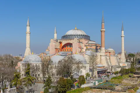
Part of it is in Europe and part is in Asia. Boats sail through the middle. Hagia Sophia is a very old building with a huge round roof.
Istanbul is Türkiye's biggest city, home to about 15.7 million people (2023). It is built on both sides of the Bosporus, so part of the city is in Europe and part is in Asia. Long ago it was called Constantinople. Hagia Sophia, finished in the year 537, was a church, then a mosque, then a museum, and it is a mosque again today.
Ankara, the capital, was a small town before it became the capital in 1923. On the west coast, at Ephesus, you can walk among the ruins of a Roman port city, including the tall front of the Library of Celsus.
Istanbul spans the Bosporus: the strait divides European Istanbul from its Asian districts, such as Üsküdar and Kadıköy. Founded as Byzantium, it was dedicated as the Roman capital, New Rome, by Constantine the Great in 330 CE and later served as capital of both the Byzantine and Ottoman empires. Its historic areas, including the 6th-century Hagia Sophia and the 16th-century Süleymaniye Mosque, were inscribed as a World Heritage Site in 1985. Hagia Sophia, built in 532–537, has been a church, a mosque (1453–1935), a museum (1935–2020) and, since 2020, a mosque again.
Ankara was one of many small provincial towns until Mustafa Kemal made it the center of the resistance after World War I; it was declared the capital in 1923. Ephesus, a World Heritage Site since 2015, preserves Hellenistic and Roman settlements that moved westward as the coastline retreated, with the Library of Celsus and the Great Theatre. In Edirne, Sinan, the most famous 16th-century Ottoman architect, considered the Selimiye Mosque complex his best work.
Mountains, plateaus and white terraces
Türkiye has lots of mountains.
The highest one is Mount Ararat. Its top has snow. In the middle of the country there are wide, high plains. At Pamukkale, warm spring water has made white stone steps.
Türkiye is a land of mountains. Only a thin strip near the coast is low and flat. The highest peak, Mount Ararat, is a volcanic mountain more than 5,100 meters tall, near the borders with Armenia and Iran. Its top is covered in snow.
In the middle is the Anatolian plateau, high plains about 900 meters above the sea, with cold winters and hot, dry summers. The ground here is still being folded into mountains, so earthquakes happen often. At Pamukkale, warm water full of minerals flows down a cliff and leaves white terraces, like frozen waterfalls.
Türkiye is predominantly mountainous: true lowland is confined to the coastal fringes, and about a quarter of the surface lies above 1,200 m. It sits in the geologically young folded-mountain zone of Eurasia, where faulting and folding are widespread and mountain building is still in progress, which makes it prone to earthquakes. The Pontic Mountains run along the Black Sea and the Taurus along the Mediterranean; Mount Ararat, a volcanic massif in the far east, is the highest peak (Britannica gives 5,165 m; Wikidata gives 5,137 m).
The climate is a dry, semicontinental variant of the Mediterranean type. The Black Sea coast is the wettest region, up to 2,438 mm of rain a year in the east, while much of the interior gets only 305–406 mm and Ankara averages about −2 °C in January. At Hierapolis-Pamukkale, a World Heritage Site since 1988, calcite-laden water from springs in a cliff almost 200 m high has built terraced basins and petrified waterfalls.

Animals of Türkiye
Wolves and bears live in Türkiye's quiet forests and hills.
Foxes and wild boars live there too. On farms, people keep sheep, cattle and water buffalo.
Türkiye has many wild animals. In quiet, wooded places you can still find wolves, foxes, wild boars, bears, deer, gazelles and wild mountain goats. Gray wolves live and hunt in family groups called packs, and they are the largest members of the dog family.
Farmers keep sheep, cattle, horses and donkeys, plus water buffalo and, on the central plateau, Angora goats. The Bosporus is busy with fish too: it is a route that fish follow each season between the Black Sea and the seas to the south.
Britannica describes Türkiye as fairly rich in wild animals and game birds: wolves, foxes, boars, wildcats, beavers, martens, jackals, hyenas, bears, deer, gazelles and mountain goats are still found in secluded and wooded regions, and partridge, wild geese, quail and bustards are the main game birds. The gray wolf (Canis lupus) is the largest member of the dog family; males weigh 30–80 kg. Brown bears (Ursus arctos) live across Europe, Asia and the Middle East, and in winter they can spend four to six months asleep in dens.
The Bosporus is heavily fished because it is a seasonal migration route for fish moving to and from the Black Sea. Its surface current runs from the Black Sea toward the Sea of Marmara, while a saltier countercurrent below flows the other way. Domestic animals include water buffalo, Angora goats on the central massif and camels in the southwest.

People, languages and food
About 86 million people live in Türkiye.
Most people speak Turkish. Many people also speak Kurdish. Eggplant, olives and yogurt are popular foods. Friends often meet for a small cup of coffee.
About 86 million people live in Türkiye, and about three in every four live in towns and cities. Turkish is the official language and the first language of most people. Many people speak Kurdish, and others speak Arabic, Armenian, Greek, Laz and other languages.
Most people are Muslim, and there are smaller Christian and Jewish communities; the country has no official religion. Eggplant, olives and yogurt are widely eaten, and arrays of small hot and cold appetizers are typical of cooking across the region. Turkish coffee is brewed slowly in a coffee pot and served in small cups with a glass of water.
About three-fourths of Türkiye's people live in towns and cities, and the coasts of the Black Sea, Marmara and Aegean, with less than two-fifths of the land, hold more than half the population. Turkish is the official language and most people's mother tongue; most of the rest speak Kurdish as a first language, and a small minority Arabic. Britannica notes that Kurds were estimated at the start of the 21st century to be almost one-fifth of the population, with majorities in several eastern provinces.
More than nine-tenths of the population is Muslim, yet the state is secular: a 1928 constitutional amendment removed Islam as the official religion. Small Jewish and Christian communities also live there. Food shares much with the wider region: eggplant, olives and yogurt are widely eaten, lamb is the staple meat, and arrays of small hot and cold appetizers are characteristic. Turkish coffee culture, in which finely ground coffee is brewed slowly to a foam and shared in coffeehouses as a sign of hospitality, was added to UNESCO's Intangible Cultural Heritage list in 2013.

A long history
People have lived in Türkiye for a very, very long time.
Long ago, people built big stone circles there. Later, Romans built cities. Istanbul was once called Constantinople. Today Türkiye is a republic.
People have lived in Türkiye for a very long time. More than 11,000 years ago, hunter-gatherers at Göbekli Tepe built huge stone rings with tall pillars carved with animals. Later, Greek and Roman cities such as Ephesus grew up along the coast.
In the year 330 the Roman emperor Constantine made the city we now call Istanbul his capital. For more than a thousand years it was the capital of the Byzantine Empire. In 1453 the Ottomans took the city, and their empire grew very large. After the Ottoman Empire ended, the Republic of Türkiye was founded in 1923, with Ankara as its capital.
At Göbekli Tepe, in the Germuş mountains of southeastern Anatolia, hunter-gatherers raised monumental megalithic enclosures between 9,600 and 8,200 BCE, with T-shaped pillars carved with wild animals; UNESCO inscribed the site in 2018. Hellenistic and Roman cities followed, and in 330 CE Constantine dedicated Byzantium as his capital, New Rome, later Constantinople. Turkmen tribes founded the Seljuq empire in Anatolia in the 11th century, and from the 14th century the Ottoman Empire expanded, taking Constantinople in 1453 and reaching its peak in the 17th century.
After Ottoman defeat in World War I, resistance led by Mustafa Kemal (later called Atatürk) fought the War of Independence of 1919–1923. On 29 October 1923 the Grand National Assembly declared a republic and elected him its first president. Reforms replaced the Arabic script with a Latin alphabet, adopted surnames (1934) and gave women the right to vote and sit in parliament. Since the 1950s governments have come from multiparty elections; Türkiye is a republic with one legislative house, the Grand National Assembly.

Türkiye on the map
Find Türkiye on the globe.
Look between Europe and Asia. The Black Sea is above it. The Mediterranean Sea is below it. A thin strip of sea splits the land in two.
Türkiye is a long, wide country, about 1,600 kilometers from west to east. The Black Sea lies to the north, the Aegean Sea to the west and the Mediterranean Sea to the south.
Three narrow waters, the Bosporus, the Sea of Marmara and the Dardanelles, link the Black Sea to the Aegean and split the small European part from the Asian part. Türkiye has land borders with eight countries: Greece and Bulgaria in Europe, and Georgia, Armenia, Azerbaijan, Iran, Iraq and Syria in Asia.
Türkiye is bounded by the Black Sea to the north, Georgia and Armenia to the northeast, Azerbaijan and Iran to the east, Iraq and Syria to the southeast, the Mediterranean and Aegean to the southwest and west, and Greece and Bulgaria to the northwest. The Bosporus, the Sea of Marmara and the Dardanelles, together the Turkish Straits, are the Black Sea's only outlet; the Bosporus is 30 km long and only 750 m wide at its narrowest.
The Bosporus separates Asian Türkiye (Anatolia) from European Türkiye, so the country is counted in both continents. Most Aegean islands are Greek; only Gökçeada and Bozcaada are Turkish. Britannica notes that the sea boundary with Greece has been a source of dispute between the two countries on numerous occasions since World War II.
- West to east
- about 1,600 km (1,000 miles)
- North to south
- about 480 to 640 km
- Boundary that is coastline
- about three-fourths of some 6,440 km
- Bosporus
- 30 km long, 750 m wide at its narrowest
Amazing facts
-
Istanbul is in two parts of the world at once.
Istanbul is built on both sides of the Bosporus, so part of the city is in Europe and part is in Asia.
The Bosporus divides European Istanbul from its Asian districts, such as Üsküdar and Kadıköy.
-
At Pamukkale, warm water made white stone steps.
At Pamukkale, mineral-rich spring water has built white terraces and stone 'waterfalls' that look frozen.
Calcite-laden water from springs in a cliff almost 200 m high created Pamukkale's mineral forests, petrified waterfalls and terraced basins.
-
People built big stone rings in Türkiye long, long ago.
At Göbekli Tepe, hunter-gatherers built rings of huge carved stone pillars more than 11,000 years ago.
Göbekli Tepe's round-oval and rectangular megalithic structures were raised by hunter-gatherers between 9,600 and 8,200 BCE, with T-shaped pillars carved with wild animals.
-
The water in the Bosporus flows two ways.
In the Bosporus, water on top flows one way, and saltier water underneath flows the other way.
A rapid surface current flows from the Black Sea to the Sea of Marmara, while a deeper countercurrent carries saltier Marmara water into the Black Sea.
-
Turkish coffee comes in a small cup with a glass of water.
Turkish coffee is brewed slowly in a coffee pot until it foams, then served in small cups with a glass of water.
UNESCO inscribed Turkish coffee culture and tradition in 2013, describing finely ground coffee, water and sugar brewed slowly to a foam and shared as a sign of hospitality.
Words to know
- peninsula
- land with water on three sides
- strait
- a narrow strip of sea that joins two larger seas
- plateau
- a wide area of high, fairly flat land
- terrace
- a flat step cut into or built up on a slope
- republic
- a country whose leaders are chosen by the people, with no king or queen
- mosque
- a building where Muslims gather to pray
- World Heritage Site
- a place UNESCO lists as important to all people, to be protected
Discovery challenge
-
What is the capital city of Türkiye?
Which city is the capital of Türkiye?
Which city was declared Türkiye's capital in 1923?
- Ankara
- Istanbul
- İzmir
Show the answer
Ankara
Ankara is the capital. Istanbul is the biggest city.
Ankara is the capital. Istanbul is bigger, but it is not the capital.
Ankara, once a small provincial town and the center of the resistance after World War I, was declared the capital in 1923.
-
Türkiye is in two parts of the world. Which two?
Türkiye lies on which two continents?
Anatolia and Turkish Thrace place Türkiye on which two continents?
- Asia and Europe
- Africa and Asia
- Europe and South America
Show the answer
Asia and Europe
Most of Türkiye is in Asia. A small part is in Europe.
Anatolia, the big part, is in Asia; Turkish Thrace, the small part, is in Europe.
Anatolia (Asia Minor) is in Asia; Turkish Thrace, beyond the Bosporus and Dardanelles, lies in the extreme southeast of Europe.
-
The Bosporus joins two seas. Which two?
Which two seas does the Bosporus join?
The Bosporus links which two bodies of water?
- The Black Sea and the Sea of Marmara
- The Red Sea and the Dead Sea
- The North Sea and the Baltic Sea
Show the answer
The Black Sea and the Sea of Marmara
The Bosporus joins the Black Sea and the Sea of Marmara.
The Bosporus runs about 30 kilometers from the Black Sea to the Sea of Marmara.
The 30 km Bosporus unites the Black Sea and the Sea of Marmara; with the Dardanelles it forms the Black Sea's only outlet.
-
What made the white steps at Pamukkale?
What built the white terraces at Pamukkale?
What formed Pamukkale's terraced basins and petrified waterfalls?
- Minerals left by spring water
- Snow and ice
- White sand blown by the wind
Show the answer
Minerals left by spring water
Warm spring water left white minerals behind. They made the steps.
Spring water full of minerals flows down the hill and leaves white stone behind, layer by layer.
UNESCO describes calcite-laden water from springs in a cliff almost 200 m high building the terraces.
-
What is the tallest mountain in Türkiye?
Which mountain is the highest in Türkiye?
Which volcanic massif, near the borders with Armenia and Iran, holds Türkiye's highest peak?
- Mount Ararat
- Mount Fuji
- Mont Blanc
Show the answer
Mount Ararat
Mount Ararat is the tallest. It has snow on top.
Mount Ararat, more than 5,100 meters tall, is Türkiye's highest mountain. It was formed by volcanoes.
Great Ararat, in a volcanic massif in eastern Türkiye, is the highest peak; published heights are 5,137 m and 5,165 m.
Places to discover in Türkiye (Turkey)
-
 Watch
City
Ankara
Ankara is the capital of Türkiye, in the interior of Anatolia, about 200 kilometers from the Black Sea. People have lived here since the Stone Age, and Romans, Byzantines, Seljuks and Ottomans all left buildings behind. It became the capital in 1923, and today it is a city of government, universities and museums.
-
 Watch
City
Istanbul
Istanbul is the biggest city in Türkiye, built on both sides of the Bosporus, the narrow strait between Europe and Asia. Once called Byzantium and then Constantinople, it was the capital of two great empires. About 15.7 million people lived in Istanbul province in 2023.
-
Watch
Landmark
Ephesus
Ephesus was a great Greek and Roman city on the west coast of what is now Türkiye. Its ruins include ancient streets, a theater for nearly 25,000 people and the Library of Celsus, whose two-story front has been rebuilt. Archaeologists have been digging there since 1895.
-
Watch
Landmark
Hagia Sophia
Hagia Sophia in Istanbul was built in under six years, from 532 to 537, for the emperor Justinian. Its enormous dome seems to float on a ring of 40 windows. Over almost 1,500 years it has been a church, a mosque and a museum, and since 2020 it has been a mosque.
-
 Watch
Landmark
Mausoleum at Halicarnassus
The Mausoleum at Halicarnassus was the tomb of Mausolus, ruler of Caria, in what is now southwestern Turkey. Built around 353 to 351 BCE, it was covered in sculptures by four famous Greek artists and became one of the Seven Wonders of the World. An earthquake probably brought it down, and its stones went into other buildings, but its name lives on in the word 'mausoleum'.
-
 Watch
Landmark
Sultan Ahmed Mosque
The Sultan Ahmed Mosque in Istanbul was built between 1609 and about 1616 for the Ottoman ruler Sultan Ahmed I. Its central dome is ringed by half-domes and smaller domes, and six slender minarets rise around it. Many people call it the Blue Mosque because of the blue and green tiles and painted decoration inside. It is still a working mosque, where Muslims come to pray.
-
 Watch
Landmark
Temple of Artemis at Ephesus
The Temple of Artemis at Ephesus was one of the Seven Wonders of the ancient world. It was rebuilt several times, and its 6th-century BCE version was more than 300 feet long. After a fire in 356 BCE it was built again just as big. Today only scattered stones and one column remain.
-
 Watch
Landmark
Topkapı Palace
Topkapı Palace sits on a point of land where the Bosphorus Strait meets the sea in Istanbul. Sultan Mehmed II built it between 1460 and 1478, and for nearly 400 years it was the home of the Ottoman sultans and the center of their government. In 1924 it became a museum.
-
 Watch
Natural wonder
Mount Ararat
Mount Ararat is a huge volcanic mountain in the far east of Türkiye, close to where Türkiye, Iran and Armenia meet. It has two peaks: Great Ararat, about 5,165 meters high and the tallest mountain in Türkiye, and the smaller, cone-shaped Little Ararat. Snow covers the top all year, and a glacier clings to its north side.
-
Watch
Natural wonder
Pamukkale
Pamukkale, in southwestern Türkiye, is a hillside of bright white terraces and pools built by warm spring water. The water is full of a dissolved mineral called calcium carbonate, and as it flows over the slope it leaves the mineral behind as a rock called travertine. Its name means "cotton castle". On top stand the ruins of Hierapolis, an ancient spa town.
Animals of Türkiye (Turkey)
-
Watch
3D
Animal
Gray wolf
The gray wolf is the largest member of the dog family and the wild ancestor of pet dogs. Wolves live in family packs that hunt big animals like elk and moose together, and their howls can carry about 10 kilometers. After being wiped out in many places, wolves are coming back in parts of North America and Europe.
-
 Watch
3D
Animal
Golden hamster
Golden hamsters, also called Syrian hamsters, are popular pets all over the world. But in the wild they live only in a small area of farmland on the border of Syria and Türkiye, and the IUCN lists them as Endangered.
Explore next
-
Watch
City
Istanbul
Istanbul is the biggest city in Türkiye, built on both sides of the Bosporus, the narrow strait between Europe and Asia. Once called Byzantium and then Constantinople, it was the capital of two great empires. About 15.7 million people lived in Istanbul province in 2023.
-
Watch
City
Ankara
Ankara is the capital of Türkiye, in the interior of Anatolia, about 200 kilometers from the Black Sea. People have lived here since the Stone Age, and Romans, Byzantines, Seljuks and Ottomans all left buildings behind. It became the capital in 1923, and today it is a city of government, universities and museums.
-
Watch
Landmark
Hagia Sophia
Hagia Sophia in Istanbul was built in under six years, from 532 to 537, for the emperor Justinian. Its enormous dome seems to float on a ring of 40 windows. Over almost 1,500 years it has been a church, a mosque and a museum, and since 2020 it has been a mosque.
-
Watch
Landmark
Ephesus
Ephesus was a great Greek and Roman city on the west coast of what is now Türkiye. Its ruins include ancient streets, a theater for nearly 25,000 people and the Library of Celsus, whose two-story front has been rebuilt. Archaeologists have been digging there since 1895.
-
Watch
Natural wonder
Pamukkale
Pamukkale, in southwestern Türkiye, is a hillside of bright white terraces and pools built by warm spring water. The water is full of a dissolved mineral called calcium carbonate, and as it flows over the slope it leaves the mineral behind as a rock called travertine. Its name means "cotton castle". On top stand the ruins of Hierapolis, an ancient spa town.
-
Watch
Natural wonder
Mount Ararat
Mount Ararat is a huge volcanic mountain in the far east of Türkiye, close to where Türkiye, Iran and Armenia meet. It has two peaks: Great Ararat, about 5,165 meters high and the tallest mountain in Türkiye, and the smaller, cone-shaped Little Ararat. Snow covers the top all year, and a glacier clings to its north side.
-
Watch
3D
Animal
Gray wolf
The gray wolf is the largest member of the dog family and the wild ancestor of pet dogs. Wolves live in family packs that hunt big animals like elk and moose together, and their howls can carry about 10 kilometers. After being wiped out in many places, wolves are coming back in parts of North America and Europe.
-
Watch
3D
Animal
Golden hamster
Golden hamsters, also called Syrian hamsters, are popular pets all over the world. But in the wild they live only in a small area of farmland on the border of Syria and Türkiye, and the IUCN lists them as Endangered.
For parents & teachers
What children will learn
- Locate Türkiye and explain how it lies on two continents, divided by the Turkish Straits.
- Describe its mountains, plateau and the spring-built terraces of Pamukkale.
- Describe the many languages, foods and ways of life in Türkiye without treating them as one culture.
- Outline its history from Göbekli Tepe through Constantinople to the republic of 1923.
Recommended ages: 3 to 17 · About 15 minutes
Talk about it
- What might it be like to live in a city where you could take a ferry from Europe to Asia?
- Why do you think more people live near Türkiye's coasts than in the high interior?
- Hagia Sophia has been used in different ways over almost 1,500 years. What old building near you has changed its use?
Try at home or in class
- On a world map, find the Bosporus and the Dardanelles and trace a ship's route from the Black Sea to the Aegean.
- Pour a little salty water and a little fresh water (with food coloring) gently into a clear glass and watch which one sinks, like the two currents in the Bosporus.
Key vocabulary: peninsula, strait, plateau, terrace, republic, mosque, World Heritage Site
Where these facts come from
- Wikidata , Wikimedia Foundation (CC0 1.0)
- Natural Earth vector data , Natural Earth (NACIS) (Public domain)
- UNESCO World Heritage List , UNESCO World Heritage Centre (Linked as a reference; site facts come from Wikidata)
- Turkey (Türkiye): introduction and quick facts , Encyclopaedia Britannica
- Turkey: land, climate, plant and animal life, people and religion , Encyclopaedia Britannica
- Turkey: settlement patterns , Encyclopaedia Britannica
- Turkey: cultural life and cuisine , Encyclopaedia Britannica
- Turkey: history , Encyclopaedia Britannica
- Turkey: declaration of the Turkish republic , Encyclopaedia Britannica
- Turkey: Kemalist policies , Encyclopaedia Britannica
- Istanbul , Encyclopaedia Britannica
- Ankara , Encyclopaedia Britannica
- Hagia Sophia , Encyclopaedia Britannica
- Bosporus , Encyclopaedia Britannica
- Mount Ararat , Encyclopaedia Britannica
- Population, total: Türkiye (SP.POP.TOTL) , World Bank
- Historic Areas of Istanbul , UNESCO World Heritage Centre
- Hierapolis-Pamukkale , UNESCO World Heritage Centre
- Ephesus , UNESCO World Heritage Centre
- Selimiye Mosque and its Social Complex , UNESCO World Heritage Centre
- Archaeological Site of Ani , UNESCO World Heritage Centre
- Göbekli Tepe , UNESCO World Heritage Centre
- Turkish coffee culture and tradition , UNESCO Intangible Cultural Heritage
- Gray wolf , Smithsonian's National Zoo and Conservation Biology Institute
- Brown bear , San Diego Zoo Wildlife Alliance
- PlayOwl region table, version 1 , PlayOwl (PlayOwl original data)
- flag-icons 7.5.0 , Panayiotis Lipiridis and contributors (MIT)
- Wikimedia Commons , Wikimedia Foundation (Per file (public domain, CC0, CC BY or CC BY-SA); see each media record)
Checked, not yet human-reviewed. Last updated October 24, 2026. Spotted a mistake? Tell us.
Picture credits
- Photo: Wolfgang Moroder, CC BY-SA 3.0, via Wikimedia Commons · source · license
- Photo: Arild Vågen, CC BY-SA 3.0, via Wikimedia Commons · source · license
- Photo: Biologg, CC BY-SA 4.0, via Wikimedia Commons · source · license
- Photo: User:Mas3cf, CC BY-SA 4.0, via Wikimedia Commons · source · license
- Photo: BerkeKayalarr, CC BY-SA 4.0, via Wikimedia Commons · source · license
- Photo: Benh LIEU SONG, CC BY-SA 3.0, via Wikimedia Commons · source · license
- Photo: Ail Subway, CC BY 3.0, via Wikimedia Commons · source · license
- Photo: I, Duesentrieb, CC BY-SA 3.0, via Wikimedia Commons · source · license
- Photo: Սէրուժ Ուրիշեան (Serouj Ourishian), CC BY-SA 4.0, via Wikimedia Commons · source · license
- Photo: Robert F. Tobler, CC BY-SA 4.0, via Wikimedia Commons · source · license
- Photo: Charles J. Sharp, CC BY-SA 4.0, via Wikimedia Commons · source · license
- Photo: Héctor Ochoa 'Robot8A', CC BY-SA 4.0, via Wikimedia Commons · source · license
- Photo: Bjørn Christian Tørrissen, CC BY-SA 3.0, via Wikimedia Commons · source · license
- Photo: Jorge Franganillo from Barcelona, Spain, CC BY 2.0, via Wikimedia Commons · source · license