
City Asia
Istanbul
Istanbul is a huge city in Türkiye. A narrow sea runs right through it. One side is in Europe, and the other side is in Asia!
Istanbul is the biggest city in Türkiye, built on both sides of the Bosporus, the narrow strait between Europe and Asia. Once called Byzantium and then Constantinople, it was the capital of two great empires. About 15.7 million people lived in Istanbul province in 2023.
Istanbul, Türkiye's largest city and chief port, straddles the Bosporus between Europe and Asia. As Constantinople it was capital of the Byzantine Empire from 330 and of the Ottoman Empire from 1457 until the 1920s. Its historic peninsula is a UNESCO World Heritage Site (1985); the province held 15,655,924 people in 2023.
Photo: Ail Subway, CC BY 3.0, via Wikimedia Commons
Discover Istanbul
Istanbul is a very big city in Türkiye.
A long, narrow sea called the Bosporus flows through the middle. Part of the city is in Europe, and part is in Asia. Boats zoom back and forth all day.
Istanbul is the largest city and busiest port in Türkiye, though it is not the capital; that is Ankara. About 15.7 million people lived in Istanbul province in 2023. The city sits on both sides of the Bosporus, a narrow strait that joins the Black Sea to the Sea of Marmara and divides Europe from Asia.
The oldest part of the city stands on a triangle of land in Europe with seven hills. For more than 2,500 years, armies, traders and travelers have passed through here, and the city has had three famous names: Byzantium, Constantinople and Istanbul.
Istanbul is Türkiye's largest city and principal seaport, and the capital in turn of the Byzantine and Ottoman empires. The old walled city stands on a triangular peninsula of about 23 km², with seven hills, six of them crests of a ridge above the Golden Horn; around their slopes stand the mosques and monuments UNESCO inscribed as the Historic Areas of Istanbul in 1985. The modern municipality spreads far beyond, on both the European and Asian shores, and Istanbul province counted 15,655,924 people in 2023.
The name has changed with its rulers. Greek Byzantium was renamed by Constantine, who dedicated it as his capital in 330 CE; the name Constantinople lasted until the Turkish Post Office officially changed it in 1930. The name Istanbul grew over centuries from a Greek phrase, eis tēn polin, "into the City", which travelers used for trips there. Britannica notes that for more than 2,500 years the city has stood, sometimes as a bridge and sometimes as a barrier, between surges of religion, culture and imperial power.
- Country
- Türkiye (largest city; not the capital)
- People (2023)
- about 15.7 million
- Old walled city
- about 23 km² on seven hills
- UNESCO World Heritage
- Historic Areas of Istanbul, 1985
Famous places
Istanbul has many famous buildings.
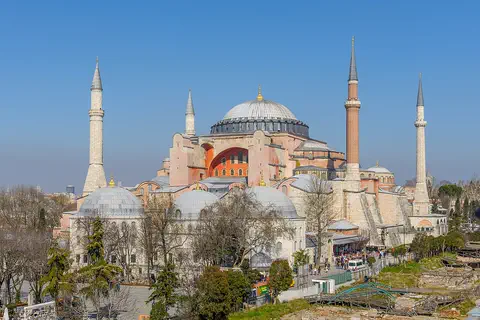
Hagia Sophia has a giant dome and tall towers called minarets. The Blue Mosque has six minarets. Topkapı Palace was home to sultans. Under the ground is a huge old water tank with hundreds of stone columns.
Hagia Sophia was built as a church from 532 to 537 for the emperor Justinian. Its dome is 32 meters across. In 1453 it became a mosque, from 1935 to 2020 it was a museum, and since 2020 it has been a mosque again. Nearby stands the mosque of Sultan Ahmed I, often called the Blue Mosque, which has six minarets instead of the usual four.
Topkapı Palace, begun in 1462, was home to the Ottoman sultans for centuries. Under the streets, the Basilica Cistern stored water on 336 columns. The Grand Bazaar once held 4,000 shops, and the Aqueduct of Valens, built in 366, still crosses a valley in the old city.
Hagia Sophia, the largest of the city's 25 surviving Byzantine churches, is essentially Justinian's 6th-century building, rebuilt after the Nika riot of 532; its dome, 32 m across, fell in an earthquake in 559 and was rebuilt to a smaller scale. It became a mosque in 1453, a museum from 1935 to 2020, and a mosque again in 2020. The great Ottoman mosques of the mid-15th to mid-16th centuries crown the seven hills; Mimar Koca Sinan's masterpiece, the Süleymaniye Mosque (1550–57), was inspired by Hagia Sophia, and the mosque of Ahmed I, the Blue Mosque, has six minarets.
Topkapı Palace, begun by Mehmed II in 1462, was the sultans' residence until the early 19th century; its courts hold the treasury and collections of manuscripts, china and textiles. Byzantine engineering survives in the two-story Aqueduct of Valens (366) and more than 80 closed cisterns, above all the Basilica Cistern with its 336 columns. The land walls, a double line built in 413 and 447 and 7 km long, were breached only once, in 1453.
- Hagia Sophia
- built 532–537; dome 32 m across
- Sultan Ahmed (Blue) Mosque
- six minarets
- Topkapı Palace
- begun 1462
- Basilica Cistern
- 336 columns
Byzantium, Constantinople, Istanbul
Long ago, Greek settlers built a town here called Byzantium.
Later, a Roman emperor made it his capital and named it Constantinople. Then the Ottoman sultans ruled from here for hundreds of years. Today it is called Istanbul.
In ancient times, Greek settlers built the town of Byzantium on the point of land between the seas. In the year 330, the Roman emperor Constantine made it his new capital, Constantinople. For more than 1,000 years it was the capital of the Byzantine Empire and a city of great wealth, protected by mighty walls.
In 1453 the Ottoman sultan Mehmed II captured the city, and it became the capital of the Ottoman Empire. The sultans built palaces, mosques, bazaars and fountains. In 1923, after the Ottoman Empire ended, Türkiye became a republic and chose Ankara as its capital, but Istanbul stayed its largest city.
Byzantium was a Greek town on the peninsula; Britannica gives its traditional founding date as about 657 BCE. Rebuilt by Septimius Severus in 196 CE, it was dedicated by Constantine the Great as his capital on May 11, 330. Constantinople became the seat of a Christian empire that lasted 1,130 years and of a patriarch from 381; under Justinian (527–565) its population is estimated at about 500,000. It withstood many sieges, but in 1204 armies of the Fourth Crusade sacked it, and Latin rule lasted until 1261.
On May 29, 1453, Mehmed II breached the land walls with cannon. He repopulated the nearly empty city with people from other regions, built Topkapı Palace and moved the Ottoman capital here from Edirne in 1457. Westernizing reforms followed in the 19th century: steamships arrived from the 1830s and the first bridge over the Golden Horn opened in 1838. After World War I the city was under Allied occupation until October 2, 1923; Ankara was chosen as capital on October 13 and the republic proclaimed on October 29. In the second half of the 20th century the population grew nearly tenfold as people moved in from the countryside.

Getting around Istanbul
In Istanbul, boats are like buses on the water.
Ferries carry people from Europe to Asia and back. Big bridges cross the water. A train even goes under the sea in a tunnel!
Because water runs through the middle of Istanbul, ferries are part of everyday life. They carry commuters across the Bosporus between Europe and Asia, and some sail south to the Princes' Islands. Buses run on the streets, and different kinds of trains run through the center.
The Bosphorus Bridge, about 1.6 kilometers long, opened in 1973. The Marmaray rail line goes through a tunnel under the Bosporus, so trains can travel from Europe to Asia under the sea. Istanbul Airport, about 50 kilometers northwest of the center, connects the city with the world.
Britannica lists the city's transport as rail lines of several kinds in the center, buses for internal transport, and maritime services from harbor dinghies and small ferries to international liners; ferries range as far as the Princes' Islands (Kızıl Adalar) to the south. The Marmaray line links the European and Asian sides through a tunnel beneath the Bosporus, and Istanbul Airport, about 50 km northwest of the center, handles international and domestic flights.
The Bosphorus Bridge, a suspension bridge about 1,560 m long, opened on October 30, 1973 (Wikidata). Crossing the water has a long history: the first bridge across the Golden Horn was built in 1838, and steamships began bringing European visitors in the 1830s. Today the city is governed through 39 district municipalities, 27 in the city itself and 12 outside it, within a metropolitan municipality.
- Marmaray
- rail tunnel under the Bosporus
- Bosphorus Bridge
- opened 1973, about 1.6 km long
- Istanbul Airport
- about 50 km northwest of the center

Weather and seasons
Istanbul has warm summers and cool, rainy winters.
Strong winds blow from the seas. Sometimes a very cold wind blows in winter. In summer, the sun shines and the sea sparkles.
Istanbul has warm, fairly dry summers and cool, wet winters. Türkiye's weather service gives an average of 6.8 °C in January and 24.7 °C in July and August. About 660 millimeters of rain fall in a year, most of it in late autumn and winter; December is the wettest month and July the driest.
Winds shape the weather. The poyraz blows from the Black Sea in the northeast. In winter an icy wind from the Balkans, the karayel, can bring hard frosts, and the lodos from the southwest can whip up storms on the Sea of Marmara.
Turkish State Meteorological Service averages for 1950–2025 give monthly means from 6.8 °C in January (6.9 °C in February) to 24.7 °C in July and August, with average highs near 29.7 °C in midsummer. Monthly precipitation ranges from 22.1 mm in July to 99.2 mm in December, about 660 mm a year in total, so most falls between October and March.
Britannica describes the winds: the prevailing northeasterly poyraz off the Black Sea; in winter the karayel, an icy blast from the Balkans capable of freezing the Golden Horn and even the Bosporus; and the lodos from the southwest, which raises storms on the Marmara. The water itself is layered: the colder, less salty Black Sea flows south through the Bosporus on the surface, while warmer, saltier Mediterranean water pushes north beneath it as a strong undercurrent.
- Average in January
- 6.8 °C
- Average in July and August
- 24.7 °C
- Rain in a year
- about 660 mm, most in winter

Living in Istanbul
Istanbul is busy day and night.
People ride ferries to work and school. They shop in markets and bazaars. Families walk by the water and watch the ships go by.
Istanbul grew enormously in the 1900s as people moved in from the countryside to find work. Today old wooden houses on narrow lanes stand near modern skyscrapers, offices and shopping malls. Ships of every size, from tiny boats to big ferries, crowd the Bosporus.
The city has more than 400 fountains, many built as gifts to the public, and many museums, including the Archaeological Museums of Istanbul and the Museum of Turkish and Islamic Art. In the Grand Bazaar, with its grid of covered streets, shoppers still bargain as they have for centuries.
Britannica describes a city where unpaved alleys with old wooden houses coexist with high-rise buildings, office parks and shopping malls, and where wide roads now cut through the historic quarters. A nearly tenfold rise in population in the second half of the 20th century strained housing and services, and early in the 21st century foreign investment drove rapid renewal, restorations and new skyscrapers, along with debate over protecting the city's heritage and green space.
Cultural institutions include the Archaeological Museums of Istanbul, the Museum of Turkish and Islamic Art, and the Köprülü Library (1677), with early Ottoman printed books and manuscripts more than 1,000 years old. The city has more than 400 fountains, the grandest built by Ahmed III in 1728 behind Hagia Sophia. Istanbul is also a religious center: since 381 it has been the seat of the patriarch of Constantinople, who remains first among equals among the leaders of the Eastern Orthodox Church.

Istanbul on the map
Find Istanbul on the globe.
It is in Türkiye, where Europe and Asia meet. A narrow sea runs through the city. To the north is the Black Sea.
Istanbul is where Europe meets Asia. The Bosporus, a narrow strait, runs through the city and links the Black Sea in the north with the Sea of Marmara in the south. From there, ships can sail on through the Dardanelles to the Mediterranean.
The old city sits on a triangle of land in Europe, with an inlet called the Golden Horn on one side and the Sea of Marmara on the other. Across the Bosporus, the Asian side of the city includes districts such as Üsküdar and Kadıköy.
Istanbul lies at about 41.1° N and 29.0° E. By tradition the waters around the old peninsula are "the three seas": the Golden Horn, a deep drowned valley about 7 km long; the Bosporus, which joins the Black Sea to the Sea of Marmara and, through the Dardanelles, to the Mediterranean; and the Sea of Marmara itself.
The narrow Golden Horn separates old Istanbul (Stamboul) on the south from Beyoğlu on the north, while the broader Bosporus divides the European districts from the Asian shore, where Üsküdar (ancient Chrysopolis) and Kadıköy (ancient Chalcedon) stand. The land walls, 7 km long, cut the peninsula off from the mainland.
- Latitude
- about 41.1° north
- Longitude
- about 29.0° east
- Golden Horn
- about 7 km long
- Land walls
- about 7 km long
Amazing facts
-
The name Istanbul came from words meaning "to the city".
Greek speakers used to say they were going "into the City" when they traveled there. Over centuries those words became the name Istanbul.
The Greek phrase eis tēn polin, "into the City", became an appellation for Constantinople by the 13th century and gradually turned into Istanbul; the official change came only in 1930.
-
A huge old water tank under the city has 336 columns.
The Basilica Cistern near Hagia Sophia is an underground water store with 336 columns rising from still, dark water.
More than 80 Byzantine closed cisterns survive; the Basilica Cistern, called the Underground Palace in Turkish, has 336 columns.
-
The sea in Istanbul flows two ways at once!
In the Bosporus, water from the Black Sea flows south on top, while saltier Mediterranean water flows north underneath.
The less salty Black Sea water runs south through the Bosporus while a powerful undercurrent of warm, salty Mediterranean water pushes north beneath it.
-
Istanbul has more than 400 fountains.
Istanbul has more than 400 fountains. Many were built as gifts so that everyone could have water.
Istanbul has more than 400 fountains, many built as public philanthropies; the grandest was built by Ahmed III in 1728.
-
The Blue Mosque has six tall towers called minarets.
The mosque of Sultan Ahmed I, called the Blue Mosque, has six minarets instead of the usual four.
The mosque of Ahmed I (sultan 1603–1617), popularly the Blue Mosque, has six minarets rather than the customary four.
Words to know
- strait
- a narrow channel of water joining two seas
- continent
- one of Earth's seven great areas of land, such as Europe or Asia
- minaret
- a tall, thin tower beside a mosque
- mosque
- a building where Muslims pray
- sultan
- the title of the rulers of the Ottoman Empire
- cistern
- a large tank for storing water, often underground
- bazaar
- a market with many small shops and stalls
Discovery challenge
-
Istanbul is on two continents. Which two?
The Bosporus divides Istanbul between which two continents?
Which two continents does the Bosporus separate at Istanbul?
- Europe and Asia
- Africa and Asia
- Europe and Africa
Show the answer
Europe and Asia
Europe and Asia! The Bosporus runs between them.
Europe and Asia. The old city is on the European side.
Europe and Asia; Üsküdar and Kadıköy stand on the Asian shore.
-
What was Istanbul called long ago?
What was Istanbul officially called until 1930?
Which name, given after the city was dedicated as a capital in 330, lasted officially until 1930?
- Constantinople
- Ankara
- Athens
Show the answer
Constantinople
Constantinople! Before that it was called Byzantium.
Constantinople, after the emperor Constantine. Ankara is Türkiye's capital today.
Constantinople, until the Turkish Post Office changed it officially in 1930.
-
How many minarets does the Blue Mosque have?
How many minarets does the Blue Mosque have?
The mosque of Ahmed I has how many minarets, instead of the customary four?
- Two
- Four
- Six
Show the answer
Six
Six! That is more than most mosques.
Six, instead of the usual four.
Six; the customary number was four.
-
How does the Marmaray train cross the Bosporus?
How does the Marmaray rail line cross from Europe to Asia?
How does the Marmaray line connect the European and Asian sides of Istanbul?
- Through a tunnel under the water
- Over a bridge
- On a ferry
Show the answer
Through a tunnel under the water
Through a tunnel under the water!
Through a tunnel under the Bosporus. Cars use bridges, and ferries carry people across too.
By tunnel beneath the strait; the Bosphorus Bridge (1973) carries road traffic above.
-
When is Istanbul warmer?
In which month is Istanbul warmer, on average?
Which month averages 24.7 °C in Istanbul?
- January
- July
Show the answer
July
July! Summer in Istanbul is warm.
July averages 24.7 °C, and January 6.8 °C.
July (and August), at 24.7 °C in the 1950–2025 averages; January is 6.8 °C.
Nearby places
-
Watch
Landmark
Topkapı Palace
Topkapı Palace sits on a point of land where the Bosphorus Strait meets the sea in Istanbul. Sultan Mehmed II built it between 1460 and 1478, and for nearly 400 years it was the home of the Ottoman sultans and the center of their government. In 1924 it became a museum.
-
Watch
Landmark
Hagia Sophia
Hagia Sophia in Istanbul was built in under six years, from 532 to 537, for the emperor Justinian. Its enormous dome seems to float on a ring of 40 windows. Over almost 1,500 years it has been a church, a mosque and a museum, and since 2020 it has been a mosque.
-
Watch
Landmark
Sultan Ahmed Mosque
The Sultan Ahmed Mosque in Istanbul was built between 1609 and about 1616 for the Ottoman ruler Sultan Ahmed I. Its central dome is ringed by half-domes and smaller domes, and six slender minarets rise around it. Many people call it the Blue Mosque because of the blue and green tiles and painted decoration inside. It is still a working mosque, where Muslims come to pray.
-
 Watch
City
Ankara
Ankara is the capital of Türkiye, in the interior of Anatolia, about 200 kilometers from the Black Sea. People have lived here since the Stone Age, and Romans, Byzantines, Seljuks and Ottomans all left buildings behind. It became the capital in 1923, and today it is a city of government, universities and museums.
-
 Watch
Natural wonder
Pamukkale
Pamukkale, in southwestern Türkiye, is a hillside of bright white terraces and pools built by warm spring water. The water is full of a dissolved mineral called calcium carbonate, and as it flows over the slope it leaves the mineral behind as a rock called travertine. Its name means "cotton castle". On top stand the ruins of Hierapolis, an ancient spa town.
-
 Watch
Landmark
Temple of Artemis at Ephesus
The Temple of Artemis at Ephesus was one of the Seven Wonders of the ancient world. It was rebuilt several times, and its 6th-century BCE version was more than 300 feet long. After a fire in 356 BCE it was built again just as big. Today only scattered stones and one column remain.
-
 Watch
Landmark
Ephesus
Ephesus was a great Greek and Roman city on the west coast of what is now Türkiye. Its ruins include ancient streets, a theater for nearly 25,000 people and the Library of Celsus, whose two-story front has been rebuilt. Archaeologists have been digging there since 1895.
-
 Watch
City
Bucharest
Bucharest, the capital of Romania, lies on a wide plain beside the Dâmbovița River. First written about in 1459, it became the capital of Walachia in 1659 and of Romania in 1862. Today it is a city of broad boulevards, a huge parliament palace, the Romanian Athenaeum concert hall and an open-air Village Museum.
Explore next
-
 Watch
 Country
Türkiye (Turkey)
Türkiye, also called Turkey, lies partly in Asia and partly in Europe. A narrow waterway called the Bosporus runs through its biggest city, Istanbul, and its land is mostly mountains and high plains. About 86 million people live there.
-
Watch
Landmark
Hagia Sophia
Hagia Sophia in Istanbul was built in under six years, from 532 to 537, for the emperor Justinian. Its enormous dome seems to float on a ring of 40 windows. Over almost 1,500 years it has been a church, a mosque and a museum, and since 2020 it has been a mosque.
-
Watch
Landmark
Topkapı Palace
Topkapı Palace sits on a point of land where the Bosphorus Strait meets the sea in Istanbul. Sultan Mehmed II built it between 1460 and 1478, and for nearly 400 years it was the home of the Ottoman sultans and the center of their government. In 1924 it became a museum.
-
Watch
Landmark
Sultan Ahmed Mosque
The Sultan Ahmed Mosque in Istanbul was built between 1609 and about 1616 for the Ottoman ruler Sultan Ahmed I. Its central dome is ringed by half-domes and smaller domes, and six slender minarets rise around it. Many people call it the Blue Mosque because of the blue and green tiles and painted decoration inside. It is still a working mosque, where Muslims come to pray.
-
 Watch
City
Rome
Rome, the capital of Italy, grew from huts on a hill beside the Tiber River into the center of a huge ancient empire. About 2.7 million people live there today (2023), among ruins such as the Colosseum and the Pantheon.
-
 Watch
City
Athens
Athens is the capital of Greece and one of the oldest cities in the world. Above it rises the Acropolis, a rocky hill crowned by the marble Parthenon, built about 2,500 years ago. Ancient Athens was home to early democracy, great thinkers and theater.
-
 Watch
City
Baghdad
Baghdad, the capital of Iraq, stands on the Tigris River in the land once called Mesopotamia. It was founded in 762 as a round city, and for about 500 years it was one of the greatest cities in the world and a great center of learning, where scholars studied math, medicine and the stars. Today it is Iraq's largest city.
-
 Watch
City
Baku
Baku, the capital of Azerbaijan, curves around a bay on the Caspian Sea, the world's largest inland body of water. Its old walled town, with the Maiden Tower and a palace of the Shirvan shahs, is a World Heritage Site, and oil has made the city important for more than 150 years.
For parents & teachers
What children will learn
- Locate Istanbul on the Bosporus and explain how it spans Europe and Asia.
- Trace the city's names from Byzantium to Constantinople to Istanbul.
- Describe how ferries, bridges and a tunnel connect a city split by water.
- Describe Hagia Sophia and other great buildings as architecture and history.
Recommended ages: 3 to 17 · About 15 minutes
Talk about it
- Istanbul has had three names. Why might a city's name change over time?
- Hagia Sophia has been a church, a mosque and a museum. What other buildings have changed jobs over time?
- If your town were split by a narrow sea, how would people cross it every day?
Try at home or in class
- Fill a clear container with salty colored water, then gently pour fresh water on top to see how two layers can flow separately, like the Bosporus.
- Draw a map of two shores with a strait between them and add a bridge, a ferry route and a tunnel.
Key vocabulary: strait, continent, minaret, mosque, sultan, cistern, bazaar
Where these facts come from
- Wikidata , Wikimedia Foundation (CC0 1.0)
- Natural Earth vector data , Natural Earth (NACIS) (Public domain)
- UNESCO World Heritage List , UNESCO World Heritage Centre (Linked as a reference; site facts come from Wikidata)
- Istanbul , Encyclopaedia Britannica
- Istanbul: Architecture , Encyclopaedia Britannica
- Istanbul: People, transportation and administration , Encyclopaedia Britannica
- Istanbul: Cultural life , Encyclopaedia Britannica
- Istanbul: Constantinople , Encyclopaedia Britannica
- Istanbul: Centuries of growth , Encyclopaedia Britannica
- Hagia Sophia , Encyclopaedia Britannica
- İl ve ilçelerimize ait istatistiki veriler: İstanbul , Turkish State Meteorological Service (MGM)
- Wikimedia Commons , Wikimedia Foundation (Per file (public domain, CC0, CC BY or CC BY-SA); see each media record)
Checked, not yet human-reviewed. Last updated October 27, 2026. Spotted a mistake? Tell us.
Picture credits
- Photo: Ail Subway, CC BY 3.0, via Wikimedia Commons · source · license
- Photo: Arild Vågen, CC BY-SA 3.0, via Wikimedia Commons · source · license
- Photo: Bjørn Christian Tørrissen, CC BY-SA 3.0, via Wikimedia Commons · source · license
- Photo: Remi Jouan, CC BY-SA 3.0, via Wikimedia Commons · source · license
- Photo: AlexTheToaster, CC BY-SA 4.0, via Wikimedia Commons · source · license
- Photo: Moonik, CC BY-SA 3.0, via Wikimedia Commons · source · license
- Photo: Hunanuk, CC0 1.0, via Wikimedia Commons · source · license