
 Country
North America
Aruba
Aruba is a small, sunny island in the Caribbean Sea. It is warm and windy all year, and it hardly rains. Cactuses grow on the hills, and white sandy beaches line the shore.
Aruba is a small island in the southern Caribbean Sea, just 29 kilometers north of Venezuela. Since 1986 it has been a self-governing country within the Kingdom of the Netherlands. It is dry, with cactuses, giant boulders and white beaches, and the 2020 census counted 108,166 people.
Aruba, 32 km long and lying 29 km north of Venezuela's Paraguaná Peninsula, left the Netherlands Antilles in 1986 to become a separate self-governing country within the Kingdom of the Netherlands. Its arid climate, with about 430 mm of rain a year, supports cactus scrub, and its drinking water is made from seawater. The 2020 census counted 108,166 people; tourism is the largest industry.
Photo: User: Bgabel at wikivoyage shared, CC BY-SA 3.0, via Wikimedia Commons
Discover Aruba
Aruba is an island in the Caribbean Sea.
It is close to South America. The weather is warm all year. The capital city is Oranjestad.
Aruba is an island in the southern Caribbean Sea, about 29 kilometers north of Venezuela and 80 kilometers northwest of Curaçao. It is 32 kilometers long and only 10 kilometers across at its widest.
Aruba is a country within the Kingdom of the Netherlands. It runs its own affairs, such as its laws and its money, the Aruban florin, while the Kingdom handles defense and relations with other countries. Dutch and Papiamento are the official languages, and the capital is Oranjestad.
Britannica places Aruba southwest of the Lesser Antilles, some 80 km northwest of Curaçao and 29 km north of Venezuela's Paraguaná Peninsula. It was part of the Netherlands Antilles until 1986, when it became a separate self-governing part of the Kingdom of the Netherlands. A governor appointed by the Dutch crown represents the monarch; a prime minister heads the Council of Ministers, which answers to the 21-member Staten (parliament).
The Aruba Tourism Authority describes the arrangement plainly: the Kingdom controls foreign affairs and defense, while laws, policies and the currency are Aruba's own. The Aruban florin is pegged to the US dollar. The 2020 census counted 108,166 people, and the statistics office's estimate for the end of 2024 was 108,423.
Oranjestad, San Nicolas and the national park
Oranjestad is the capital and main port.
Its buildings are painted pink, yellow and white. Big ships come to its harbor. A national park covers part of the island.
Oranjestad, on the southwest coast, is the capital and the main port. The photo, taken from the cruise-ship harbor, shows its pink, yellow and white buildings with red roofs, palm trees and low hills behind.
San Nicolas, near the southeastern tip, is where oil refining began in the 1920s. Nearly a fifth of the island is Arikok National Park, with caves, old rock drawings, rocky hills and quiet bays such as Boca Prins and Dos Playa.
Oranjestad is the capital and main port; its two census regions held 28,658 people in 2020. San Nicolas (Sint Nicolaas), in the southeast, was the port where oil refining began in the 1920s.
The Aruba Tourism Authority says nearly 20% of the island is national park. Arikok National Park covers 7,907 acres of caves, Indigenous rock drawings and land formations of lava, quartz diorite and limestone, with dry riverbeds leading to bays such as Moro, Boca Prins and Dos Playa. Rock drawings can also be seen at Fontein Cave in the park and at the Ayo Rock Formation.
A dry island of cactuses and boulders
Aruba is warm and dry.
A steady wind blows from the sea. Cactuses and tough shrubs grow. Some giant rocks are piled on top of each other.
Aruba is mostly low, with a few steep hills. The highest point is Mount Jamanota, 188 meters high, and a pointed hill called the Hooiberg, or Haystack, rises to 171 meters. In some places, huge boulders sit piled on top of one another.
The temperature stays near 27 °C all year, and the trade winds from the northeast keep it from feeling too hot. Only about 430 millimeters of rain falls in a year, and the plants that grow wild are cactuses, shrubs and trees that can survive drought. Aruba lies outside the usual path of hurricanes, though one sometimes reaches it.
Britannica describes an island of igneous rock overlain by limestone, fringed with coral reefs, with steep isolated hills such as the Hooiberg (171 m) and immense monolithic diorite boulders stacked in places. Mount Jamanota is 188 m in Wikidata and 189 m in Britannica. The soil is barren with little or no natural irrigation.
The annual average temperature is 27 °C, tempered by northeasterly trade winds; precipitation is low and variable, about 430 mm a year, and natural vegetation is drought-resistant cacti, shrubs and trees. Aruba lies outside the usual hurricane path. With no natural freshwater sources such as groundwater, rivers or lakes, the island's utility, WEB Aruba, makes drinking water by desalinating seawater; it has produced the island's water since 1932.
Burrowing owls and sea turtles
A small owl lives in holes in the ground. Arubans call it the shoco.
Sea turtles come to the beaches to lay eggs.
Aruba has its own kind of burrowing owl, called the shoco, that lives nowhere else. It is the island's national symbol. People have reported owls near schools and sports fields, but cutting down trees and fast building work are the biggest dangers to their homes and nests.
Four kinds of sea turtles, the hawksbill, loggerhead, green and leatherback, come ashore from March to December to lay eggs. Laws protect them and their nests, and people are asked to keep their distance from a nesting turtle. The animal photos here were taken in other places.
The shoco (Athene cunicularia arubensis), a burrowing owl found only on Aruba, is the island's national symbol. In a citizen-science survey run by the Department of Nature and Environment, residents sent 87 reports from 2020 to 2026; pairs were the most common sighting (38% of reports), and owls were increasingly seen near urban areas such as schools and sports fields. The department names deforestation and fast construction as the greatest threats to its habitat, along with disturbance and destroyed nests.
The department says four sea turtle species, hawksbill, loggerhead, green and leatherback, come ashore from March to December to nest, and that local and international laws protect turtles and nests; the TurtugAruba Foundation monitors nesting. The burrowing owl photo was taken in California and the turtle photos elsewhere.

Papiamento, Carnival and many backgrounds
Arubans speak Papiamento and Dutch.
Many also speak English and Spanish. Carnival is a big, colorful celebration.
Many Arubans have mixed family roots, including Indigenous, Dutch, Spanish and African ancestors. The official languages are Dutch and Papiamento, a language that grew mainly from Portuguese, Spanish and Dutch. English and Spanish are widely spoken too.
New Year's Day and Carnival, before Lent, are especially colorful celebrations. Tourism is the largest industry, and visitors come for the long white beaches and clear water. Drinking water is made from seawater in a desalination plant.
Britannica describes most Arubans as ethnically mixed, many with Indigenous ancestry combined with Dutch, Spanish and African heritage, and notes that Aruba had few slave-based plantations compared with most Caribbean islands. Papiamento (Papiamentu), also spoken on Curaçao and Bonaire, is a creole that grew mainly from Portuguese, Spanish and Dutch; it and Dutch are official, and English and Spanish are widely used.
Services, centered on tourism, form the basis of the economy. The Aruba Tourism Authority dates tourism's growth from the 1950s and says it became the largest industry in the 1990s. Britannica singles out the pre-Lenten Carnival and New Year's festivities as especially colorful and popular celebrations.
Caquetio villages, oil and Status Aparte
Long ago, people came to Aruba in canoes.
They drew pictures in caves. Later, Spain and then the Netherlands ruled. In 1986 Aruba got its own government.
The first people paddled canoes from South America. Around 1,000 years ago the Caquetio people arrived and built villages, and rock drawings from that time can still be seen in caves.
Spanish sailors came in the early 1500s, and the Dutch took over in 1636. Later, people mined gold and grew aloe. In the 1920s oil refineries opened, and after the main one closed in 1985, Aruba built up tourism. In 1986 Aruba left the Netherlands Antilles and became its own country within the Kingdom of the Netherlands.
The Aruba Tourism Authority describes Archaic peoples arriving by canoe from the mainland, followed by about 900–1000 CE by the Caquetios, who built at least five villages and grew maize and manioc; two rock drawings have been dated to around 1000 CE. Spaniards arrived between 1502 and 1505, and in 1514 took an estimated 2,000 Caquetios to Hispaniola as enslaved laborers, though some were later sent back.
The Dutch occupied the island in 1636; Britain held it from 1806 to 1816. Gold mining ran from 1824 into the early 20th century, and aloe was grown for medicines. The Lago refinery (1924) at San Nicolas processed Venezuelan crude; its closure in 1985 caused a serious economic crisis, and Arubans responded by expanding tourism; Britannica adds that it reopened in 1990 and closed again in 2012. In 1986 Aruba left the Netherlands Antilles with 'Status Aparte', a campaign led by Betico Croes; a plan for full independence was postponed in 1990 and dropped in 1995.
Aruba on the map
Find South America on the globe.
Look at its top edge, by the Caribbean Sea. Just above Venezuela is a small island. That is Aruba.
Aruba sits just off the northern coast of South America, 29 kilometers north of Venezuela, about 12.5 degrees north of the equator. Curaçao is 80 kilometers to the southeast, and the Lesser Antilles, a long curve of small islands, lie to the northeast.
Aruba's white-sand beaches are on its south and west sides, while its northeast coast, facing the trade winds, is rugged.
Aruba has no land borders. It is so small that the globe shows it with a marker rather than an outline.
Aruba lies at about 12.5° N, 70° W, 29 km north of the Paraguaná Peninsula and 80 km northwest of Curaçao, southwest of the Lesser Antilles arc. It has no land borders. At the globe's scale the island has no outline of its own, so PlayOwl marks it with points: Oranjestad, San Nicolas, Mount Jamanota and the Hooiberg.
- Island size
- 32 × 10 km
- Venezuela's coast
- 29 km south
- People (2020 census)
- 108,166
- Rain in a year
- about 430 mm
Amazing facts
-
Aruba's drinking water is made from seawater.
Aruba has no rivers, lakes or groundwater to drink, so its water company takes the salt out of seawater. The company has produced the island's water since 1932.
With no natural freshwater sources, Aruba relies on seawater desalination by WEB Aruba, which has produced water since 1932 and electricity since 1958.
-
A hill on Aruba is called the Haystack.
The Hooiberg, whose name means Haystack, is a steep hill 171 meters high.
The Hooiberg ('Haystack'), 171 m, is one of the isolated, steep-sided hills that characterize Aruba's landscape.
-
Aruba's national symbol is a little owl.
The shoco, a burrowing owl found only on Aruba, is the island's national symbol.
Athene cunicularia arubensis, the shoco, is endemic to Aruba and its national symbol; a citizen survey has often recorded it near schools and sports fields.
-
Some rock drawings in Aruba's caves are about 1,000 years old.
Two of the rock drawings made by Aruba's Indigenous people have been dated to around the year 1000.
Of the Indigenous rock drawings at sites such as Fontein Cave and Ayo, two have been dated to about 1000 CE, when both Archaic and Caquetio peoples lived on the island.
Words to know
- desalination
- taking the salt out of seawater to make fresh water
- trade winds
- steady winds that blow toward the equator, from the northeast north of it
- creole
- a language that grew from a mix of other languages and became people's first language
- endemic
- found naturally in one place and nowhere else
- refinery
- a factory that turns crude oil into fuels such as gasoline
- arid
- very dry, with little rain
Discovery challenge
-
Where does Aruba get its drinking water?
How does Aruba get its drinking water?
What is the source of Aruba's drinking water?
- From big rivers
- From seawater
- From melting snow
Show the answer
From seawater
From seawater! The salt is taken out.
Seawater. Aruba has no rivers or lakes, so the salt is taken out of seawater.
Seawater desalination; Aruba has no groundwater, rivers or lakes to use.
-
Which country is very close to Aruba?
Which country's coast is just 29 kilometers south of Aruba?
Aruba lies 29 km north of the Paraguaná Peninsula of which country?
- Venezuela
- Mexico
- Brazil
Show the answer
Venezuela
Venezuela is very close.
Venezuela, in South America.
Venezuela; the Paraguaná Peninsula is 29 km south.
-
What is Aruba's national symbol?
Which animal, found only on Aruba, is the island's national symbol?
Which endemic animal, Athene cunicularia arubensis, is Aruba's national symbol?
- A parrot
- A sea turtle
- A burrowing owl
Show the answer
A burrowing owl
A little owl called the shoco.
The shoco, Aruba's own burrowing owl.
The shoco, an endemic burrowing owl threatened by habitat loss.
-
In which year did Aruba get its own government in the Kingdom?
In which year did Aruba leave the Netherlands Antilles?
In which year did Aruba gain 'Status Aparte' within the Kingdom of the Netherlands?
- 1636
- 1924
- 1986
Show the answer
1986
It was 1986.
1986. Aruba became a separate country within the Kingdom of the Netherlands.
1986, after a campaign led by Betico Croes.
Places to discover in Aruba
-
 Watch
City
Oranjestad
Oranjestad is the capital and largest town of Aruba, a small, dry island in the Caribbean Sea, just north of South America. White sand beaches and most of Aruba's tourist resorts are on its west and south coasts. The 2020 census counted 28,658 people in its two census regions, Oranjestad West and Oranjestad Oost.
-
 Watch
Natural wonder
Caribbean Sea
The US National Hurricane Center counts the Caribbean Sea as part of the Atlantic basin. Along the coast of Belize lies the largest barrier reef in the northern hemisphere, UNESCO says. Far below, in the Cayman Trough, the sea floor is slowly spreading apart, and scientists have found hot springs there almost 5,000 meters down.
Animals of Aruba
-
Watch
Animal
Burrowing owl
The burrowing owl is a small, sandy-brown owl with long legs and bright yellow eyes. Unlike most owls, it lives underground, in burrows dug by prairie dogs, ground squirrels or tortoises, or sometimes by the owls themselves. It lives in open grasslands and deserts from Canada to the tip of South America.
-
 Watch
3D
Animal
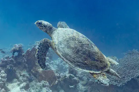
Hawksbill sea turtle
The hawksbill sea turtle lives in warm seas around the world, mostly near coral reefs. Its pointed, hawk-like beak reaches into cracks in the reef to find sponges, its favorite food. Its beautiful patterned shell once made it a target for hunters, and today it is critically endangered.
-
 Watch
Animal
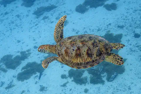
Green sea turtle
The green sea turtle is the largest sea turtle with a hard shell. It lives in warm seas around the world and, unlike other sea turtles, grown-ups eat mostly seagrass and algae. Females swim hundreds or even thousands of kilometers to lay their eggs on the beaches where they hatched long ago.
-
 Watch
Animal
Leatherback sea turtle
The leatherback sea turtle is the largest turtle on Earth. Instead of a hard shell it has tough, rubbery skin over a layer of tiny bones. It eats jellyfish, dives deeper than any other turtle and swims thousands of kilometers between feeding waters and the beaches where it lays its eggs.
Explore next
-
Watch
City
Oranjestad
Oranjestad is the capital and largest town of Aruba, a small, dry island in the Caribbean Sea, just north of South America. White sand beaches and most of Aruba's tourist resorts are on its west and south coasts. The 2020 census counted 28,658 people in its two census regions, Oranjestad West and Oranjestad Oost.
-
 Watch
 Country
Netherlands
The Netherlands is a small, flat country in northwestern Europe on the North Sea. Its name means low-lying country: more than a quarter of it lies below sea level, protected by dunes and dikes. About 18.2 million people lived there in 2026, and its capital is Amsterdam, a city of canals.
-
 Watch
 Country
Venezuela
Venezuela is a country on the north coast of South America. It has high Andes mountains, huge grassy plains called the Llanos, the great Orinoco River and flat-topped mountains called tepuis, where Angel Falls drops 979 meters.
-
 Watch
 Country
Curaçao
Curaçao is an island in the southern Caribbean, about 60 kilometers north of Venezuela. Since 2010 it has been a country within the Kingdom of the Netherlands. Its capital, Willemstad, is famous for colorful buildings around a deep natural harbor, now a World Heritage site, and the 2023 census counted 155,826 people.
-
Watch
Natural wonder
Caribbean Sea
The US National Hurricane Center counts the Caribbean Sea as part of the Atlantic basin. Along the coast of Belize lies the largest barrier reef in the northern hemisphere, UNESCO says. Far below, in the Cayman Trough, the sea floor is slowly spreading apart, and scientists have found hot springs there almost 5,000 meters down.
-
Watch
Animal
Burrowing owl
The burrowing owl is a small, sandy-brown owl with long legs and bright yellow eyes. Unlike most owls, it lives underground, in burrows dug by prairie dogs, ground squirrels or tortoises, or sometimes by the owls themselves. It lives in open grasslands and deserts from Canada to the tip of South America.
-
Watch
3D
Animal
Hawksbill sea turtle
The hawksbill sea turtle lives in warm seas around the world, mostly near coral reefs. Its pointed, hawk-like beak reaches into cracks in the reef to find sponges, its favorite food. Its beautiful patterned shell once made it a target for hunters, and today it is critically endangered.
-
Watch
Animal
Green sea turtle
The green sea turtle is the largest sea turtle with a hard shell. It lives in warm seas around the world and, unlike other sea turtles, grown-ups eat mostly seagrass and algae. Females swim hundreds or even thousands of kilometers to lay their eggs on the beaches where they hatched long ago.
For parents & teachers
What children will learn
- Locate Aruba off the coast of Venezuela and describe its dry climate.
- Explain how Aruba makes drinking water from seawater, and why it needs to.
- Describe Aruba's languages and the many backgrounds of its people.
- Outline Aruba's history from Caquetio villages to Status Aparte in 1986.
Recommended ages: 3 to 17 · About 15 minutes
Talk about it
- What would change in your day if all your water had to be made from seawater?
- Why might people start building near the nests of an owl, and how could a town share space with it?
- Aruba is part of a kingdom but runs its own affairs. What things might a small island want to decide for itself?
Try at home or in class
- With a grown-up, put salty water in a bowl in the sun, cover it with plastic wrap with a pebble in the middle over a cup, and see fresh water drip into the cup: a tiny solar desalination model.
- Find Aruba, Curaçao and Bonaire on a map and measure how far each is from South America.
Key vocabulary: desalination, trade winds, creole, endemic, refinery, arid
Where these facts come from
- Wikidata , Wikimedia Foundation (CC0 1.0)
- Natural Earth vector data , Natural Earth (NACIS) (Public domain)
- Aruba (land, climate, people, economy, government, culture) , Encyclopaedia Britannica
- Aruba: regions and zones, 2000, 2010 and 2020 census (from the Central Bureau of Statistics Aruba) , City Population (Thomas Brinkhoff)
- Aruba: census regions and urban areas, with the 31 December 2024 estimate , City Population (Thomas Brinkhoff)
- History , Aruba Tourism Authority
- Arikok National Park , Aruba Tourism Authority
- Water production , WEB Aruba N.V.
- The community provides crucial information about the survival of the burrowing owl on Aruba , Government of Aruba
- It is the season when sea turtles nest on the beach , Government of Aruba
- PlayOwl region table, version 1 , PlayOwl (PlayOwl original data)
- flag-icons 7.5.0 , Panayiotis Lipiridis and contributors (MIT)
- Wikimedia Commons , Wikimedia Foundation (Per file (public domain, CC0, CC BY or CC BY-SA); see each media record)
Checked, not yet human-reviewed. Last updated November 1, 2026. Spotted a mistake? Tell us.
Picture credits
- Photo: User: Bgabel at wikivoyage shared, CC BY-SA 3.0, via Wikimedia Commons · source · license
- Photo: © Frank Schulenburg, CC BY-SA 4.0, via Wikimedia Commons · source · license
- Photo: Diego Delso, CC BY-SA 4.0, via Wikimedia Commons · source · license
- Photo: Charles J. Sharp, CC BY-SA 4.0, via Wikimedia Commons · source · license