
 Country
Europe
Netherlands
The Netherlands is a flat country in Europe. It is next to the sea. Much of its land is very low. Walls of earth keep the water out.
The Netherlands is a small, flat country in northwestern Europe on the North Sea. Its name means low-lying country: more than a quarter of it lies below sea level, protected by dunes and dikes. About 18.2 million people lived there in 2026, and its capital is Amsterdam, a city of canals.
The Netherlands is the low, flat land where the Rhine and Maas flow west to the North Sea. More than half the country lies no higher than about 1 m above sea level and more than a quarter below it, and some 6,500 km² of land has been reclaimed through water management dating to medieval times. Statistics Netherlands counted 18,171,612 people at the end of August 2026; Amsterdam is the capital, and The Hague the seat of government.
Photo: Atamari, CC BY-SA 4.0, via Wikimedia Commons
Discover the Netherlands
The Netherlands is a country in Europe.
Its land is very flat. A lot of it is lower than the sea. Walls of earth called dikes keep the water out. The capital city is Amsterdam.
The Netherlands is in northwestern Europe. The North Sea lies to the north and west, Germany to the east and Belgium to the south. The name Netherlands means low-lying country, and it fits: more than half the land is no more than about 1 meter above sea level, and more than a quarter of it is below sea level.
The country is also called Holland, although Holland is really the name of two of its 12 provinces. Without its dunes and dikes, the most crowded part of the country would be flooded. About 18.2 million people lived in the Netherlands in 2026. Its capital is Amsterdam, but the government meets in The Hague.
The Netherlands is bounded by the North Sea to the north and west, Germany to the east and Belgium to the south. Britannica describes the most developed part of the country, more than half its area, as lying no higher than about 1 m above sea level, and more than a quarter of the total area as lying below it; without dunes and dikes, it would be inundated, largely by the sea and partly by the rivers. Holland (from Houtland, wooded land) is properly the name of two of the 12 provinces, Noord-Holland and Zuid-Holland.
Statistics Netherlands (CBS) counted 18,171,612 inhabitants at the end of August 2026. A parliamentary democracy under a constitutional monarch, the kingdom also includes Aruba, Bonaire, Curaçao, Saba, Sint Eustatius and Sint Maarten in the Lesser Antilles. Amsterdam is the capital and The Hague the seat of government.
Cities and famous places
Amsterdam has lots of canals.
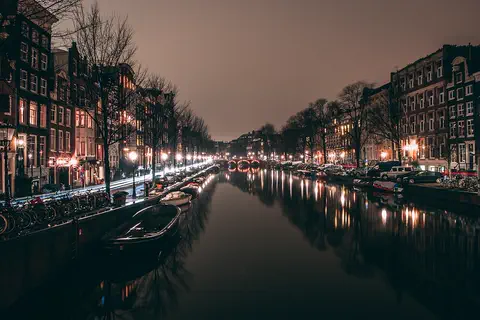
Canals are rivers that people dig. Boats float on them. Old houses with pointed roofs stand along the water. At night, the lights shine on the canals.
Amsterdam, the capital, was built around a ring of canals dug at the end of the 1500s and in the 1600s. The canals were part of a plan to drain swampy land and make the city bigger, with gabled houses along the water. Today the canal district is a World Heritage Site.
Rotterdam, the second largest city, is a major European port. Its old city center was destroyed by bombing in World War II, and it was rebuilt. The Hague is where the government meets, and it is home to the International Court of Justice. Each spring, more than a million visitors come to see the flowers at Keukenhof.
Amsterdam's canal district, inscribed by UNESCO in 2010, was built as a new port city at the end of the 16th and beginning of the 17th centuries: swampland was drained with canals in concentric arcs and the spaces between were filled in and built up with gabled houses. UNESCO calls it the largest and most homogeneous urban extension of its time and a model of town planning until the 19th century.
Rotterdam, the second largest city and a major European port, gained the New Waterway to the North Sea between 1866 and 1872; its city center and more than a third of the port were destroyed in World War II. The Hague, seat of government, hosts the International Court of Justice. Keukenhof, which opened as a spring flower park in 1950, now shows 7 million spring-flowering bulbs over eight weeks to about 1.4 million visitors a year. At Kinderdijk (UNESCO, 1997), 19 drainage mills, among them the 16 of De Nederwaard and De Overwaard built in 1738 and 1740, still work as fall-back pumps.
Low land, water and weather
The Netherlands is very flat.
It has lots of lakes, rivers and canals. People turned wet land into dry fields. The weather is often cloudy, with rain all year.
The Netherlands is flat, with many lakes, rivers and canals. Over hundreds of years, people turned about 6,500 square kilometers of sea, lakes and marshes into dry land. These new pieces of land are called polders, and most are surrounded by dikes. At first people and horses did the draining, then windmills, and later steam and electric pumps.
The great rivers, the Rhine, Waal, Lek and Maas, flow across the middle of the country to the sea. The climate is mild, with gentle winters, cool summers and rain in every season. The land rises above about 105 meters only in the far southeast, where the Vaalserberg reaches 321 meters.
During the late Pleistocene the Scandinavian ice sheet covered the northern half of the Netherlands, leaving moraine; in the center and south the Rhine and Maas laid down thick silt and gravel. In the Holocene, clay settled in lagoons behind the coastal dunes and peat formed; where peat was washed or dug away, lakes appeared, many later reclaimed. About 6,500 km² is reclaimed land, mostly polders ringed by dikes, drained first by people and horses, then by windmills, steam and electric or diesel pumps. On polder land, buildings need rafts or concrete piles up to 20 m long.
In 1932 the Afsluitdijk, which Rijkswaterstaat gives as 32 km long, sealed off the Zuiderzee, creating the IJsselmeer and room for four polders of about 1,700 km². After the 1953 North Sea flood killed 1,836 people, the Delta Works dams, completed in 1986, shortened the coastline by 700 km. The climate is temperate: July averages about 17 °C, January about 2 °C, and rain averages about 790 mm a year.

Animals of the Netherlands
Seals live in the Wadden Sea, along the coast.
Huge flocks of birds fly through the Netherlands. Deer and foxes live in the nature parks.
Along the north coast lies the Wadden Sea, the largest unbroken stretch of tidal sand and mud flats in the world. At low tide, the mud is uncovered. Seabirds, shellfish, harbor seals, gray seals and harbor porpoises all live there.
Huge numbers of birds pass through the Netherlands on their migrations, and some stay for the summer or the winter. There are many kinds of water birds, marsh birds and meadow birds. Larger mammals, such as roe deer, red deer, foxes and badgers, live mostly in nature reserves like the Hoge Veluwe National Park. Wild boars and beavers have been brought in or brought back in some places.
The Wadden Sea, a World Heritage Site since 2009 (extended in 2014) and now shared with Germany and Denmark, is the largest unbroken system of intertidal sand and mud flats in the world, with tidal channels, sea-grass meadows, mussel beds, salt marshes and dunes; UNESCO names the harbor seal, gray seal and harbor porpoise among its marine mammals. Britannica notes that seabirds and mollusks are found especially there and in the far southwest.
Migrating birds pass through in huge numbers, and waterbirds, marsh and pasture birds are numerous. Roe deer, red deer, foxes and badgers are mostly restricted to nature reserves such as the Naardermeer, the Hoge Veluwe National Park and the Oostvaardersplassen. Boars, beavers, fallow deer, mouflons and muskrats have been introduced or reintroduced locally. Some reptiles and amphibians are endangered, and many river fish have become scarce because of water pollution.
People, languages and food
About 18 million people live in the Netherlands.
Most people speak Dutch. In Friesland, many people also speak Frisian. Many people ride bicycles. Some people eat pancakes and Gouda cheese.
About 18.2 million people lived in the Netherlands in 2026, and it is one of the most densely populated countries in the world. Many live in the Randstad, a horseshoe of cities in the west that includes Amsterdam, Rotterdam, The Hague and Utrecht. Dutch is spoken in the whole country, and in the northern province of Friesland people also speak their own language, Frisian.
Cycling is popular for getting to work, for fun and for sport, and at least half the population cycles. Dutch foods include filled pancakes, spice cookies called speculaas and hard cheeses such as Edam and Gouda, named after the towns where they began.
CBS counted 18,171,612 people at the end of August 2026; Britannica calls the Netherlands one of the world's most densely populated countries. In the west, the bulk of the population is concentrated in the Randstad, the horseshoe-shaped urban core of Rotterdam, The Hague, Leiden, Haarlem, Amsterdam, Hilversum and Utrecht. Dutch, a Germanic language, is spoken throughout; Frisian, spoken in Friesland, is closer to English than to Dutch or German. Immigrants have come for centuries, in the 20th century from Indonesia, the Moluccas and Suriname and later from Turkey and Morocco; in the early 21st century one-fifth of the population had been born abroad or had at least one foreign-born parent.
Britannica divides formal religious allegiance into three almost equal groups, Roman Catholics, Protestants and the nonreligious, with Muslims about 6 percent at the turn of the century. Cycling involves at least half the population. Dutch cuisine includes pannekoeken, oliebollen and speculaas, Edam and Gouda cheeses, and the Indonesian rijsttafel, a staple in larger cities. The Elfstedentocht ice-skating race through 11 Frisian cities is held only in winters with heavy ice.

A history of trade and water
Long ago, Dutch ships sailed all over the world to trade.
Painters made famous pictures. People built windmills to pump water. Today the Netherlands has a king.
In 1579 northern provinces joined together in the Union of Utrecht to resist Spanish rule, and this became the start of a new country, the Dutch Republic. In the 1600s, its Golden Age, Dutch merchant ships traded across the world, and painters such as Rembrandt were at work. Some of this trade, especially by the West India Company, was in enslaved people.
In the early 1800s the Netherlands became a kingdom. During World War II, Germany occupied the country from 1940 until it was freed in May 1945. After a terrible flood in 1953, the Dutch built the Delta Works to hold back the sea. Today the Netherlands has a king and an elected parliament.
The Union of Utrecht of January 23, 1579, a league of northern provinces resisting Spanish rule, became the foundation of the United Provinces, or Dutch Republic; the 1581 Act of Abjuration declared that Philip II had forfeited his sovereignty. The Golden Age, from 1609 to about 1713, saw the Dutch dominate much of Europe's trade and shipping. The United East India Company (1602) set up bases in Sri Lanka, India and the Indonesian archipelago, and the West India Company (1621) relied more on the trade in enslaved people, in which Britannica says the Dutch were preeminent in the 17th century.
After French domination, a constitutional monarchy was established in 1814, and William I became king. Nazi Germany invaded in 1940; under occupation the large majority of Dutch Jews were deported to their deaths, and the country was near famine in the Hunger Winter before liberation in May 1945. In Indonesia a nationalist revolution followed the war, and Suriname became independent in 1975. The Netherlands joined NATO and the European Communities; Willem-Alexander became king in 2013.

The Netherlands on the map
Find the Netherlands on the globe.
It is in Europe, next to the North Sea. It is next to Germany and Belgium. Big rivers cross it to reach the sea.
The Netherlands is in northwestern Europe. The North Sea lies along its north and west coasts. Germany is its neighbor to the east and Belgium to the south. Big rivers, including the Rhine and the Maas, flow across the country from east to west to the sea.
In the north, a long dam called the Afsluitdijk separates a big lake, the IJsselmeer, from the sea, and the Wadden Sea lies along the north coast. Far away in the Caribbean Sea, six islands, including Aruba and Curaçao, are also part of the Kingdom of the Netherlands.
The European Netherlands borders the North Sea to the north and west, Germany to the east and Belgium to the south. The Rhine, Lek, Waal and Maas cross its center from east to west, lined by high dikes, orchards and long bridges; in the southwest, the Delta Works dams close most of the sea inlets, but the New Waterway to Rotterdam and the Western Schelde to Antwerp were left open for shipping.
The land rises only in the east, where Saale glaciation ice pushed up sand ridges of more than 100 m in the Veluwe, and in the far southeastern corner, where the Vaalserberg reaches 321 m, the highest point of the European part. The kingdom also includes six Caribbean islands in the Lesser Antilles (Aruba, Bonaire, Curaçao, Saba, Sint Eustatius and Sint Maarten); Mount Scenery, 870 m, on Saba, is higher than anywhere in the European part.
- Neighbors
- Germany to the east, Belgium to the south, the North Sea to the north and west
- Land below sea level
- more than a quarter of the country
- Reclaimed land
- about 6,500 km²
- Highest point (European part)
- Vaalserberg, 321 m
Amazing facts
-
More than a quarter of the Netherlands is lower than the sea.
More than a quarter of the Netherlands lies below sea level, kept dry by dunes, dikes and pumps.
More than half the Netherlands lies no higher than about 1 m above sea level, and more than a quarter of the total area lies below it.
-
Old windmills at Kinderdijk can still pump water.
The 19 windmills at Kinderdijk still work. They are kept ready in case the modern pumps break down.
Kinderdijk's 19 drainage mills, including 16 built in 1738 and 1740, are all in operating condition as fall-back mills for the modern pumping stations.
-
Gouda cheese is named after a Dutch town.
Edam and Gouda cheeses are named after the Dutch towns where they began.
Edam and Gouda, the world-renowned hard cheeses, originated in the towns whose names they carry.
-
A skating race in the Netherlands goes through 11 towns.
The Elfstedentocht is an ice-skating race through 11 cities in Friesland. It can only be held when winter brings very thick ice.
The Elfstedentocht, a skating race through 11 cities of Friesland, takes place only in winters with heavy ice.
-
The Wadden Sea has huge mud flats.
The Wadden Sea has the largest unbroken stretch of tidal sand and mud flats in the world.
UNESCO describes the Wadden Sea, shared by the Netherlands, Germany and Denmark, as the largest unbroken system of intertidal sand and mud flats in the world.
Words to know
- dike
- a long wall of earth or stone built to keep water out
- polder
- low land that people have won from the sea, a lake or a marsh by building dikes and draining the water
- sea level
- the average height of the ocean's surface, used to measure how high or low land is
- canal
- a waterway that people dig for boats or to drain water
- mud flat
- a wide stretch of mud that the sea covers at high tide and uncovers at low tide
- constitutional monarchy
- a country with a king or queen whose powers are limited by law, with an elected parliament
Discovery challenge
-
What is the capital city of the Netherlands?
Which city is the capital of the Netherlands?
Which city is the capital of the Netherlands, although the seat of government is The Hague?
- The Hague
- Amsterdam
- Rotterdam
Show the answer
Amsterdam
Amsterdam is the capital. It has lots of canals.
Amsterdam is the capital. The government meets in The Hague, and Rotterdam is a big port.
Amsterdam is the capital and The Hague the seat of government; Rotterdam is the second largest city and a major European port.
-
What does the name Netherlands mean?
What does the name Netherlands mean?
The name Netherlands describes the country's land. What does it mean?
- Land of mountains
- Low-lying country
- Land of islands
Show the answer
Low-lying country
It means low land. A lot of the land is lower than the sea.
Netherlands means low-lying country. More than a quarter of it is below sea level.
Netherlands means low-lying country: more than half the land is no higher than about 1 m above sea level, and more than a quarter lies below it.
-
What did people build long ago to pump water off the land?
Before steam pumps, what machines did the Dutch use to drain water from the land?
Which machines, such as the 19 at Kinderdijk, replaced people and horses in draining polders before steam pumps?
- Windmills
- Water wheels on boats
- Steam trains
Show the answer
Windmills
People built windmills. The wind turned them to move water.
First people and horses drained the land, then windmills, and later steam and electric pumps.
Britannica describes drainage by people and horses, then windmills such as the Kinderdijk-Elshout network, then steam, electric and diesel pumps.
-
What is the Afsluitdijk?
What is the Afsluitdijk, finished in 1932?
What was the Afsluitdijk, completed in 1932, built to do?
- A long dam that closed off part of the sea
- A flower park full of tulips
- A tall tower in Amsterdam
Show the answer
A long dam that closed off part of the sea
The Afsluitdijk is a long wall in the water. A road runs on top.
The Afsluitdijk is a dam about 32 kilometers long. It closed off the Zuiderzee, and its southern part became a lake, the IJsselmeer.
The 32 km dam sealed the Zuiderzee from the Wadden Sea and the North Sea, creating the freshwater IJsselmeer with its polders.
-
Which sea animal lives in the Wadden Sea?
Which sea mammal lives in the Wadden Sea, off the Dutch coast?
Which marine mammal does UNESCO name in the Wadden Sea, along with the gray seal and harbor porpoise?
- Polar bear
- Harbor seal
- Walrus
Show the answer
Harbor seal
Harbor seals live in the Wadden Sea.
Harbor seals, gray seals and harbor porpoises live in the Wadden Sea.
UNESCO names the harbor seal, gray seal and harbor porpoise among the Wadden Sea's marine mammals.
Places to discover in Netherlands
-
Watch
City
Amsterdam
Amsterdam is the capital of the Netherlands. It began as a fishing village beside a dam on the Amstel River, which gave the city its name. Today about 942,000 people live among its rings of canals, hundreds of bridges, houseboats and bicycles.
-
 Watch
Natural wonder
Rhine
The Rhine begins as two small streams high in the Swiss Alps and flows about 1,230 kilometers north and west to the North Sea, through Switzerland, Germany, France and the Netherlands. It tumbles over the Rhine Falls and winds through a gorge lined with castles. After a chemical spill in 1986, the countries along it worked together to clean it, and salmon came back.
Animals of Netherlands
-
 Watch
3D
Animal
Harbor seal
The harbor seal lives along the northern coasts of North America, Europe and Asia, and it is one of the most common marine mammals on the east and west coasts of the United States. It has spotted fur, a dog-like face and no ear flaps, and it wriggles like a caterpillar on land. Its pups can swim within minutes of being born.
-
 Watch
3D
Animal
Harbor porpoise
The harbor porpoise is a small relative of whales and dolphins. It lives in cool coastal waters of the Northern Hemisphere, in bays, harbors and fjords. It is shy, usually swims alone or in tiny groups, and rolls quietly to the surface to breathe.
Explore next
-
Watch
City
Amsterdam
Amsterdam is the capital of the Netherlands. It began as a fishing village beside a dam on the Amstel River, which gave the city its name. Today about 942,000 people live among its rings of canals, hundreds of bridges, houseboats and bicycles.
-
Watch
3D
Animal
Harbor seal
The harbor seal lives along the northern coasts of North America, Europe and Asia, and it is one of the most common marine mammals on the east and west coasts of the United States. It has spotted fur, a dog-like face and no ear flaps, and it wriggles like a caterpillar on land. Its pups can swim within minutes of being born.
-
Watch
Life around the world
Getting around Amsterdam by bicycle
Amsterdam, the capital of the Netherlands, is flat and crossed by canals. In 2017, about 35 out of every 100 weekday trips made by people who live there were by bicycle, more than by car, bus, tram or metro. The city has added thousands of bike parking places, including a garage under the water by Central Station.
-
Watch
3D
Animal
Harbor porpoise
The harbor porpoise is a small relative of whales and dolphins. It lives in cool coastal waters of the Northern Hemisphere, in bays, harbors and fjords. It is shy, usually swims alone or in tiny groups, and rolls quietly to the surface to breathe.
-
Watch
Natural wonder
Rhine
The Rhine begins as two small streams high in the Swiss Alps and flows about 1,230 kilometers north and west to the North Sea, through Switzerland, Germany, France and the Netherlands. It tumbles over the Rhine Falls and winds through a gorge lined with castles. After a chemical spill in 1986, the countries along it worked together to clean it, and salmon came back.
-
 Watch
 Country
Belarus
Belarus is a landlocked country in eastern Europe. Ice sheets of the last ice age shaped its low hills and wide plains, it has more than 10,000 lakes and one of Europe's largest wetlands, and about 9.1 million people lived there in 2025.
-
 Watch
 Country
Bosnia and Herzegovina
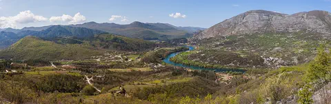
Bosnia and Herzegovina is a mountainous country in southeastern Europe. It has forests, limestone hills and many rivers, and famous old stone bridges cross some of them. Its capital is Sarajevo. It touches the Adriatic Sea along only about 20 kilometers of coast.
-
 Watch
 Country
Bulgaria
Bulgaria is a country on the eastern side of the Balkan Peninsula, with the Danube River to the north and the Black Sea to the east. Mountains cross it from west to east, and about 6.4 million people lived there at the end of 2025.
For parents & teachers
What children will learn
- Locate the Netherlands, its neighbors, its great rivers and the North Sea coast.
- Explain what dikes, polders, pumps and dams do, and why the low country needs them.
- Describe some of the Netherlands' cities, wildlife and ways of life without treating them as one single culture.
- Outline Dutch history from the Union of Utrecht (1579) to the Delta Works.
Recommended ages: 3 to 17 · About 15 minutes
Talk about it
- If your home were below sea level, what would you want to know about the dikes that protect it?
- Why do you think so many people in the Netherlands ride bicycles?
- What are the good and hard parts of turning a lake or marsh into farmland?
Try at home or in class
- In a baking tray, build a wall of modeling clay or sand, pour water on one side and see whether your dike keeps the other side dry.
- Make a paper pinwheel and blow on it to see how wind can turn the sails of a windmill.
Key vocabulary: dike, polder, sea level, canal, mud flat, constitutional monarchy
Where these facts come from
- Wikidata , Wikimedia Foundation (CC0 1.0)
- Natural Earth vector data , Natural Earth (NACIS) (Public domain)
- UNESCO World Heritage List , UNESCO World Heritage Centre (Linked as a reference; site facts come from Wikidata)
- Netherlands (introduction, land, climate, plant and animal life) , Encyclopaedia Britannica
- Netherlands: People , Encyclopaedia Britannica
- Netherlands: Cultural life , Encyclopaedia Britannica
- Netherlands: History , Encyclopaedia Britannica
- Netherlands: Dutch civilization in the Golden Age (1609–1713) , Encyclopaedia Britannica
- Netherlands: The period of French dominance (1795–1813) , Encyclopaedia Britannica
- Netherlands: Queen Wilhelmina and World War I (to World War II and after) , Encyclopaedia Britannica
- Netherlands: Into the 21st century , Encyclopaedia Britannica
- Delta Works , Encyclopaedia Britannica
- Polder , Encyclopaedia Britannica
- Amsterdam , Encyclopaedia Britannica
- Rotterdam , Encyclopaedia Britannica
- The Hague , Encyclopaedia Britannica
- Seventeenth-Century Canal Ring Area of Amsterdam inside the Singelgracht , UNESCO World Heritage Centre
- Mill Network at Kinderdijk-Elshout , UNESCO World Heritage Centre
- Wadden Sea , UNESCO World Heritage Centre
- About Keukenhof , Keukenhof
- Afsluitdijk , Rijkswaterstaat
- Population dynamics; month and year (table 83474ENG, 2026) , Statistics Netherlands (CBS)
- PlayOwl region table, version 1 , PlayOwl (PlayOwl original data)
- flag-icons 7.5.0 , Panayiotis Lipiridis and contributors (MIT)
- Wikimedia Commons , Wikimedia Foundation (Per file (public domain, CC0, CC BY or CC BY-SA); see each media record)
Checked, not yet human-reviewed. Last updated October 27, 2026. Spotted a mistake? Tell us.
Picture credits
- Photo: Atamari, CC BY-SA 4.0, via Wikimedia Commons · source · license
- Photo: GillyBerlin, CC BY 2.0, via Wikimedia Commons · source · license
- Photo: C messier, CC BY-SA 4.0, via Wikimedia Commons · source · license
- Photo: Edwin van Buuringen from The Hague, Netherlands, CC BY 2.0, via Wikimedia Commons · source · license
- Photo: Mlefter, CC BY-SA 3.0, via Wikimedia Commons · source · license