
 Country
North America
Curaçao
Curaçao is a sunny island in the Caribbean Sea, near South America. Its capital has rows of brightly painted houses by the water. Sea turtles lay eggs in small bays on its north coast.
Curaçao is an island in the southern Caribbean, about 60 kilometers north of Venezuela. Since 2010 it has been a country within the Kingdom of the Netherlands. Its capital, Willemstad, is famous for colorful buildings around a deep natural harbor, now a World Heritage site, and the 2023 census counted 155,826 people.
Curaçao, 60 km off Venezuela on the South American continental shelf, became a constituent country of the Kingdom of the Netherlands on 10 October 2010, when the Netherlands Antilles were dissolved. The Dutch trading settlement founded in 1634 grew into Willemstad, a UNESCO World Heritage site since 1997. The 2023 census counted 155,826 people.
Photo: Martin Falbisoner, CC BY-SA 4.0, via Wikimedia Commons
Discover Curaçao
Curaçao is an island in the Caribbean Sea.
It is close to South America. The capital is Willemstad. People speak Papiamentu, Dutch and English.
Curaçao lies in the southern Caribbean Sea, about 60 kilometers north of the coast of Venezuela. Its neighbors Aruba and Bonaire are nearby.
Curaçao is a country within the Kingdom of the Netherlands. The Dutch king is head of state, but Curaçao has its own prime minister and parliament to run things at home, while the Kingdom looks after defense and relations with other countries. Papiamentu, Dutch and English are all official languages, and the capital is Willemstad.
Britannica describes Curaçao as an island country within the Kingdom of the Netherlands, about 60 km north of Venezuela; though it sits on the South American continental shelf, it and its neighbors are usually counted as the southwestern arc of the Lesser Antilles.
The Dutch monarch is head of state, represented by a governor; a prime minister and Council of Ministers hold executive power, and the 21-member Parliament (Staten) is elected by proportional representation. Curaçao is largely autonomous in domestic affairs, while the Kingdom remains responsible for defense, foreign relations and certain other matters. Dutch, Papiamentu and English are official, and Curaçao shares its guilder currency with Sint Maarten.
Willemstad, a harbor town of many colors
Willemstad has houses painted yellow, blue, pink and green.
They stand in a row beside the water. Ships sail right through the middle of the town.
Willemstad grew around one of the best natural harbors in the Caribbean. A channel called Sint Anna Bay runs through the town to a big, sheltered bay behind it, splitting the old center into two sides, Punda and Otrobanda.
The Dutch began the town in 1634 by building Fort Amsterdam. Its historic districts are famous for buildings painted red, blue, yellow and green, some with curved Dutch gables. In 1997 the historic area became a UNESCO World Heritage site. The photos show the Handelskade, Willemstad's colorful waterfront.
UNESCO's listing describes Willemstad as a colonial trading and administrative settlement that began with Fort Amsterdam (1634) on the east bank of Sint Anna Bay, the channel that leads through the reefs to the deep, almost enclosed Schottegat. Punda, the oldest district, dates from the 17th century and was the only one walled; Pietermaai, Otrobanda and Scharloo date from the 18th.
The tradition of colorful exteriors in red, blue, yellow ochre and green continues, and a distinctive Curaçao Baroque style uses the curved Dutch gable, best known on the Penha Building of 1708, the yellow building at right in the hero photo. The 86-hectare site was inscribed in 1997. UNESCO notes damage from a 1960s highway and the access roads of the Queen Juliana Bridge (1974), and pressure from tourism development.

Dry hills, wild coasts and coral reefs
Curaçao is warm and dry.
The tallest hill is in a big national park. On the north coast, huge waves crash into rocky bays.
Curaçao gets little rain and has little rich soil. Most of its drinking water is made by taking the salt out of seawater.
In the west, Christoffel National Park is the island's largest park and has its highest peak, Christoffel Mountain. Beside it, Shete Boka National Park protects almost 10 kilometers of rocky north coast, where huge waves thunder into a cave at Boka Tabla. Coral reefs grow off the island, and the Curaçao Marine Park works to protect and restore them.
Britannica notes scant rainfall and little fertile soil, and that most drinking water comes from seawater desalination. The research foundation CARMABI, founded in 1955 as a marine research institute, manages five national parks. Christoffel National Park, the largest and most biodiverse, holds the highest peak, Christoffelberg (375 m in Wikidata).
Shete Boka National Park, established in 1994, covers almost 10 km of the rocky, wave-exposed north coast, where waves thunder into an underground cavern at Boka Tabla and limestone bluffs and a natural bridge at Boka Wandomi line the shore. The Curaçao Marine Park conserves the island's coral reefs and supports coral restoration research, and the Rif Mangrove Park protects mangroves in the city.
Deer, sea turtles and reefs
White-tailed deer live in Curaçao's big national park.
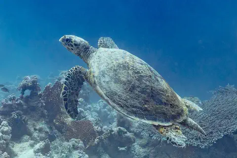
Sea turtles swim to small beaches to lay their eggs.
The white-tailed deer is Curaçao's national animal, and it lives in Christoffel National Park, along with many birds and plants that are hard to see elsewhere on the island.
On the north coast, three kinds of sea turtles lay their eggs in about ten small bays in Shete Boka National Park, mostly between May and December. Scientists check the beaches for signs of nesting. The deer photo here was taken in Missouri, in the United States, and the turtle photo in Egypt.
The Christoffel park describes the white-tailed deer as the national deer and the park as the island's most biodiverse, with birds and plants not easily seen elsewhere on Curaçao.
Shete Boka National Park was established in 1994 to protect sea turtle nesting areas: about 10 pocket bays where three species are known to lay eggs. CARMABI researchers monitor the beaches through the nesting season, roughly May to December. The deer photo shows a white-tailed doe in Missouri, United States, and the hawksbill photo was taken at Ras Muhammad, Egypt.
Papiamentu, the port and trade
People here speak Papiamentu, Dutch and English.
Big ships come to the harbor. Many visitors come to see the colorful town.
The 2023 census counted 155,826 people. Papiamentu, Dutch and English are all official languages. Curaçao's people have roots in Africa, Europe, South America and elsewhere.
For much of the 1900s, oil from Venezuela was refined here, but the refinery closed in 2019. Today tourism, trade, shipping, port services and financial services drive the economy, and aloe plants are still grown for medicines.
Curaçao's Central Bureau of Statistics counted 155,826 people in the census of 2 September 2023 and estimated 156,115 on 1 January 2025. UNESCO notes that Afro-American, Iberian and Caribbean inhabitants enriched Willemstad's building traditions and cultural life; Britannica records Sephardic Jewish immigrants from Amsterdam and Dutch Brazil from the mid-17th century, forming one of the oldest Jewish communities in the Americas.
Britannica traces the 20th-century economy to refining Venezuelan oil, which made Willemstad one of the Caribbean's principal ports, with dry docks, bunkering and storage; the sector declined after the Isla refinery closed in 2019. Today tourism, international trade, shipping and port services and financial services drive the economy, and aloes, first brought from Africa, are still exported for pharmaceutical uses.
Caquetío, Dutch traders and a new country
Long ago, the Caquetío people lived on Curaçao.
Later, ships came from Spain and then the Netherlands. In 2010 Curaçao became its own country in the Kingdom.
The first people on Curaçao were the Caquetío, who came from nearby South America. Spanish explorers arrived in 1499, and in 1634 the Dutch took the island and built a busy trading port.
The island became a center of the slave trade, and many enslaved Africans were forced to work or were sold on to other places. In 1795 an enslaved man named Tula led a revolt for freedom. It was stopped, but Tula is remembered as a symbol of the struggle for freedom. In 2010 Curaçao became a country within the Kingdom of the Netherlands.
Britannica names the Arawak-speaking Caquetío as the original inhabitants. An expedition under Alonso de Ojeda arrived in 1499, and under Spanish rule many Indigenous people were deported for forced labor. The Dutch seized Curaçao in 1634 and made it a commercial and maritime center of the Dutch West India Company; in the 17th and 18th centuries it was a major center of the transatlantic slave trade. In 1795 Tula led a major uprising against slavery; it was suppressed but remains a lasting symbol of the struggle for freedom.
After brief British occupation in the Napoleonic Wars, Dutch control returned in 1815. In 1845 Curaçao was one of six Dutch Caribbean dependencies placed under one administration; in 1954 they became the Netherlands Antilles, autonomous in domestic affairs. After a 2006 agreement to dissolve the Antilles, Curaçao became a constituent country on 10 October 2010, alongside Aruba (1986) and Sint Maarten.
Curaçao on the map
Find South America on the globe.
Look at its top edge, by the Caribbean Sea. Just above Venezuela is a long island. That is Curaçao.
Curaçao lies just off the northern coast of South America, about 12 degrees north of the equator and 60 kilometers north of Venezuela. Aruba is to the west and Bonaire to the east.
Curaçao has no land borders. It is too small for the globe to draw, so PlayOwl marks it with dots: Willemstad, the Queen Emma Bridge, Christoffel Mountain and Shete Boka National Park.
Curaçao lies at about 12.1° N, 69° W, 60 km north of Venezuela on the South American continental shelf, between Aruba to the west and Bonaire to the east. It has no land borders.
At the globe's scale the island has no outline of its own, so the map uses markers: Willemstad and the Queen Emma Bridge across Sint Anna Bay in the southeast, Christoffelberg and Shete Boka in the northwest.
- Distance to Venezuela
- about 60 km
- Land area
- 444 km²
- People (2023 census)
- 155,826
- World Heritage since
- 1997
Amazing facts
-
Willemstad's houses are painted red, blue, yellow and green.
Willemstad keeps up an old tradition of painting its buildings red, blue, yellow and green.
UNESCO notes that Willemstad's tradition of colorful exteriors in red, blue, yellow ochre and green continues today.
-
Waves crash right into a cave on Curaçao's north coast.
At Boka Tabla, huge waves thunder into an underground cave, and visitors can watch from steps cut into the rock.
At Boka Tabla in Shete Boka National Park, surf rolls into an underground cavern reached by steps cut into the rock.
-
Most of Curaçao's drinking water comes from the sea.
Curaçao has little fresh water, so most of its drinking water is made by taking the salt out of seawater.
Because freshwater resources are limited, most of Curaçao's potable water is produced by seawater desalination.
-
One famous yellow building in Willemstad is more than 300 years old.
The yellow Penha Building on Willemstad's waterfront dates from 1708 and has a curved Dutch gable.
The Penha Building (1708) is the best-known example of the curved Dutch gable of Curaçao Baroque architecture.
Words to know
- harbor
- a sheltered area of water where ships can stay safely
- gable
- the pointed or curved top of a building's end wall
- World Heritage site
- a place UNESCO lists as so important that it should be protected for everyone
- constituent country
- one of the countries that together make up a kingdom
- desalination
- taking the salt out of seawater to make fresh water
- uprising
- a time when people stand up together against those who rule them
Discovery challenge
-
What is the capital of Curaçao?
Which town, famous for its colorful waterfront, is Curaçao's capital?
Which capital grew from a Dutch trading settlement founded with Fort Amsterdam in 1634?
- Willemstad
- Amsterdam
- Caracas
Show the answer
Willemstad
Willemstad.
Willemstad, a World Heritage site since 1997.
Willemstad, on Sint Anna Bay.
-
Which animals lay eggs in the bays of Curaçao's north coast?
Which animals come ashore to lay eggs in the small bays of Shete Boka?
Shete Boka National Park was set up in 1994 to protect the nesting areas of which animals?
- Penguins
- Sea turtles
- Crocodiles
Show the answer
Sea turtles
Sea turtles!
Sea turtles. Three kinds nest there.
Sea turtles; three species nest in about 10 pocket bays.
-
Which country is very close to Curaçao?
Curaçao lies about 60 kilometers north of which country?
Curaçao sits on the continental shelf of South America, 60 km north of which country?
- Mexico
- Venezuela
- Canada
Show the answer
Venezuela
Venezuela.
Venezuela, in South America.
Venezuela, whose oil was refined on Curaçao for much of the 20th century.
-
In which year did Curaçao become its own country in the Kingdom?
In which year did Curaçao become a country within the Kingdom of the Netherlands?
In which year were the Netherlands Antilles dissolved, making Curaçao a constituent country?
- 1634
- 1954
- 2010
Show the answer
2010
It was 2010.
2010, when the Netherlands Antilles were broken up.
2010, on 10 October.
Places to discover in Curaçao
-
Watch
City
Willemstad
Willemstad is the capital of Curaçao, an island in the southern Caribbean near the tip of South America. Its old districts stand around a deep natural harbor, and its historic area, with red, blue, yellow and green buildings, is a World Heritage Site. The 2023 census counted 155,826 people on the whole island.
-
 Watch
Natural wonder
Caribbean Sea
The US National Hurricane Center counts the Caribbean Sea as part of the Atlantic basin. Along the coast of Belize lies the largest barrier reef in the northern hemisphere, UNESCO says. Far below, in the Cayman Trough, the sea floor is slowly spreading apart, and scientists have found hot springs there almost 5,000 meters down.
Animals of Curaçao
-
 Watch
Animal
White-tailed deer
White-tailed deer live in forests, fields and even towns from Canada down to South America. They are named for the white underside of the tail, which they hold up like a flag when they run. Males grow new antlers every year.
-
Watch
3D
Animal
Hawksbill sea turtle
The hawksbill sea turtle lives in warm seas around the world, mostly near coral reefs. Its pointed, hawk-like beak reaches into cracks in the reef to find sponges, its favorite food. Its beautiful patterned shell once made it a target for hunters, and today it is critically endangered.
Explore next
-
Watch
City
Willemstad
Willemstad is the capital of Curaçao, an island in the southern Caribbean near the tip of South America. Its old districts stand around a deep natural harbor, and its historic area, with red, blue, yellow and green buildings, is a World Heritage Site. The 2023 census counted 155,826 people on the whole island.
-
 Watch
 Country
Aruba
Aruba is a small island in the southern Caribbean Sea, just 29 kilometers north of Venezuela. Since 1986 it has been a self-governing country within the Kingdom of the Netherlands. It is dry, with cactuses, giant boulders and white beaches, and the 2020 census counted 108,166 people.
-
 Watch
 Country
Netherlands
The Netherlands is a small, flat country in northwestern Europe on the North Sea. Its name means low-lying country: more than a quarter of it lies below sea level, protected by dunes and dikes. About 18.2 million people lived there in 2026, and its capital is Amsterdam, a city of canals.
-
 Watch
 Country
Venezuela
Venezuela is a country on the north coast of South America. It has high Andes mountains, huge grassy plains called the Llanos, the great Orinoco River and flat-topped mountains called tepuis, where Angel Falls drops 979 meters.
-
 Watch
 Country
Sint Maarten
Sint Maarten covers the southern third of the island of Saint Martin, in the northeastern Caribbean Sea. It is a country within the Kingdom of the Netherlands, and its capital is Philipsburg. The northern part of the same island is Saint-Martin, which belongs to France. About 42,449 people lived in Sint Maarten at the start of 2025.
-
Watch
Natural wonder
Caribbean Sea
The US National Hurricane Center counts the Caribbean Sea as part of the Atlantic basin. Along the coast of Belize lies the largest barrier reef in the northern hemisphere, UNESCO says. Far below, in the Cayman Trough, the sea floor is slowly spreading apart, and scientists have found hot springs there almost 5,000 meters down.
-
Watch
Animal
White-tailed deer
White-tailed deer live in forests, fields and even towns from Canada down to South America. They are named for the white underside of the tail, which they hold up like a flag when they run. Males grow new antlers every year.
-
Watch
3D
Animal
Hawksbill sea turtle
The hawksbill sea turtle lives in warm seas around the world, mostly near coral reefs. Its pointed, hawk-like beak reaches into cracks in the reef to find sponges, its favorite food. Its beautiful patterned shell once made it a target for hunters, and today it is critically endangered.
For parents & teachers
What children will learn
- Locate Curaçao off the coast of Venezuela and describe its status in the Kingdom of the Netherlands.
- Describe historic Willemstad and why it is a World Heritage site.
- Explain how Curaçao gets fresh water and how its parks protect turtles and reefs.
- Outline Curaçao's history, including the slave trade and Tula's uprising, in calm, factual terms.
Recommended ages: 3 to 17 · About 15 minutes
Talk about it
- Why might a town paint its buildings bright colors, and why might people want to keep that tradition?
- How can people visiting a beach help sea turtles that nest there?
- Tula is remembered as a symbol of the struggle for freedom. Why do people remember those who stood up for freedom?
Try at home or in class
- Draw a row of houses with curved gables like the Penha Building and color them red, blue, yellow and green.
- On a map, measure the distances from Curaçao to Aruba, Bonaire and Venezuela.
Key vocabulary: harbor, gable, World Heritage site, constituent country, desalination, uprising
Where these facts come from
- Wikidata , Wikimedia Foundation (CC0 1.0)
- Natural Earth vector data , Natural Earth (NACIS) (Public domain)
- Curaçao (history, government, economy) , Encyclopaedia Britannica
- Historic Area of Willemstad, Inner City and Harbour, Curaçao , UNESCO World Heritage Centre
- Curaçao: island and places, census 2001 to 2023 and 2025 estimate (from the Central Bureau of Statistics Curaçao) , City Population (Thomas Brinkhoff)
- Central Bureau of Statistics Curaçao (Census 2023 results) , Central Bureau of Statistics Curaçao
- CARMABI: park management , CARMABI Foundation
- Christoffel National Park , Christoffel National Park (CARMABI)
- Shete Boka National Park , Shete Boka National Park (CARMABI)
- PlayOwl region table, version 1 , PlayOwl (PlayOwl original data)
- flag-icons 7.5.0 , Panayiotis Lipiridis and contributors (MIT)
- Wikimedia Commons , Wikimedia Foundation (Per file (public domain, CC0, CC BY or CC BY-SA); see each media record)
Checked, not yet human-reviewed. Last updated November 1, 2026. Spotted a mistake? Tell us.
Picture credits
- Photo: Martin Falbisoner, CC BY-SA 4.0, via Wikimedia Commons · source · license
- Photo: Coolcaesar, CC BY 4.0, via Wikimedia Commons · source · license
- Photo: Diego Delso, CC BY-SA 4.0, via Wikimedia Commons · source · license
- Photo: Hillebrand Steve, U.S. Fish and Wildlife Service, public domain, via Wikimedia Commons · source