
 Country
Africa
Madagascar
Madagascar is a very big island near Africa. Lemurs, chameleons and many other animals live there and nowhere else.
Madagascar is the fourth-largest island in the world, in the Indian Ocean off southeastern Africa. It split from other land more than 60 million years ago, so many of its plants and animals, such as its lemurs, live nowhere else. About 32.7 million people lived there in 2025.
Madagascar, the world's fourth-largest island, lies about 400 km off southeastern Africa across the Mozambique Channel and has been separated from all other land masses for at least 60-80 million years. Its biota evolved in isolation, with endemism of about 80 to 90 percent in its eastern rainforests, and its people, about 32.74 million in 2025 by the World Bank's estimate, speak an Austronesian language.
Photo: Souvaroff, CC BY-SA 3.0, via Wikimedia Commons
Discover Madagascar
Madagascar is a country on a big island.
It is in the Indian Ocean, near Africa. It has rainforests, high hills and long beaches. The capital city is Antananarivo.
Madagascar is an island country in the Indian Ocean, about 400 kilometers off the southeastern coast of Africa. A stretch of sea called the Mozambique Channel lies between them. It is the fourth-largest island in the world, after Greenland, New Guinea and Borneo.
Madagascar has been separated from all other land for more than 60 million years, so its plants and animals developed on their own. About 32.7 million people lived there in 2025. The capital, Antananarivo, stands high on the central plateau.
Madagascar lies off southeastern Africa, separated from the continent by the Mozambique Channel; Britannica gives the distance as some 400 km and ranks it the fourth-largest island after Greenland, New Guinea and Borneo. UNESCO notes that it has been separated from all other land masses for at least 60-80 million years, so most of its plant and animal life evolved in isolation.
Britannica stresses a second unusual feature: although the island is close to Africa, the Malagasy language belongs to the Western Malayo-Polynesian branch of the Austronesian family, pointing to Indonesian origins, with African influences added. The World Bank estimated the population at 32,740,678 in 2025, on 587,295 square kilometers. Antananarivo, on the central plateau, is the capital.
Cities and famous places
Antananarivo is the capital city.
It is built on high, steep hills. Toamasina is a big port on the east coast. Tall, sharp rocks called tsingy stand in the west.
Antananarivo, the capital, is by far the largest city. Its old part sits on two steep ridges, crowned by the ruins of the Queen's Palace, and about 1.3 million people lived there in 2018. Toamasina, on the east coast, is the main port, and Antsirabe, south of the capital, is a town many visitors come to.
Madagascar has World Heritage Sites of nature too. In the east, six national parks protect the Rainforests of the Atsinanana. In the west, the Tsingy de Bemaraha has a 'forest' of sharp limestone pinnacles up to 100 meters high.
Britannica notes that Antananarivo, Fianarantsoa and Toamasina predate French rule. Antananarivo, the capital of the Merina kingdom from the late 16th century, is perched on two precipitous ridges, its old quarter dominated by the ruins of the Queen's Palace (Manjakamiadana); about 1.28 million people lived there in 2018. Other large cities include Mahajanga on the northwest coast, Toamasina on the east coast, Antsiranana in the north and Toliara in the southwest, while Antsirabe is mainly a tourist center.
UNESCO inscribed the Rainforests of the Atsinanana, six national parks along the east, in 2007; they were on the List of World Heritage in Danger from 2010 to 2025, and a UNESCO news item in 2009 reported threats from illegal logging and trafficking of precious wood. The Andrefana Dry Forests, first inscribed in 1990 as the Tsingy de Bemaraha reserve, include karst limestone cut into pinnacles up to 100 m high, a 'forest of sharp stones', and the canyon of the Manambolo River.

Plateau, cliffs and coasts
The middle of Madagascar is high and hilly.
The east side is rainy and green. The southwest is very dry. Much of the soil is red, so people call it the Great Red Island.
Madagascar has three long zones. In the middle is a high central plateau, 800 to 1,400 meters above the sea. On the east, it drops down a steep cliff to a narrow coastal plain with a chain of lagoons. On the west, it steps down to wide, low plains. The highest point, Maromokotro, reaches 2,876 meters in the north.
Much of the rock breaks down into red earth, which gives Madagascar its nickname, the Great Red Island. The hot, wet season lasts from November to April. Winds bring heavy rain to the east coast, but the southwest is almost a desert, and tropical cyclones can strike the east from December to March.
Britannica describes three parallel zones. The central plateau, 800-1,400 m high and tilted west, carries three massifs above 2,600 m: Tsaratanana, whose summit Maromokotro (2,876 m) is the island's highest point; the volcanic Ankaratra (Tsiafajavona, 2,643 m); and granite Andringitra (2,658 m). To the east the plateau falls in steps of 300-600 m down the Great Cliff (Cliff of Angavo) to a coastal strip about 50 km wide, whose lagoons are linked by the Pangalanes Canal, more than 600 km long. The western zone, 100-200 km wide, has sedimentary hills, mangroves and river deltas. Gneiss weathers into red murrum, laterite and fertile red earths, the source of the name Great Red Island.
The southeast trade winds blow all year and the northwest monsoon in the hot season, from November to April. Windward Maroantsetra receives nearly 3,800 mm of rain a year and Antananarivo about 1,200 mm, while the southwest lies in a rain shadow, almost desert, with about 360 mm at Toliara. Tropical cyclones approach the east coast especially from December to March, bringing torrential rains and floods.
Animals and plants found nowhere else
About 40 kinds of lemurs live in Madagascar.
Many kinds of chameleons, big and small, live there. Tenrecs look a bit like hedgehogs. Strange spiny plants and baobab trees grow in the dry south.
Because Madagascar was cut off for so long, many of its animals evolved into unique forms. About 40 kinds of lemurs, primates related to monkeys, live on the island. Tenrecs, small animals that look a bit like hedgehogs, evolved there, and there are many kinds of chameleons. About 800 kinds of butterflies have been found.
In the eastern rainforests, about 80 to 90 percent of the plants and animals are found nowhere else. Much of the island's forest has been cut down for rice fields, fuel, building and timber, so what remains is very precious. In the dry south grow thorn trees, dwarf baobabs and spiny succulents found only in Madagascar.
Britannica attributes the island's anomalous wildlife to isolation: about 40 species of lemurs are indigenous, several unique hedgehoglike insectivores such as the tenrec evolved there, and chameleons of many sizes abound. Birds include guinea fowl, ibis, flamingos and birds of prey; there are about 800 butterfly species; the only large dangerous animals are river crocodiles, and the snakes, including the do (3-4 m), are harmless. The coelacanth, once thought extinct for millions of years, lives offshore.
UNESCO puts endemism in the Rainforests of the Atsinanana at about 80 to 90 percent for all groups, with many threatened primates, and describes the western Andrefana Dry Forests as centers of endemism holding ancient lineages such as the mesites, an endemic bird order about 54 million years old. Forest once covered much of the island, but little remains except on the eastern escarpment and in western pockets; about seven-eighths is now grass, bamboo or thin woodland, and the arid south has thorn trees, dwarf baobabs and pachypodium succulents.
People, languages and ways of life
More than 32 million people live in Madagascar.
Most people speak Malagasy. Many speak French too. Farmers grow rice in the valleys. Cattle are kept all over the island.
More than nine-tenths of the people are Malagasy, made up of about 20 groups, such as the Merina, the Betsimisaraka and the Betsileo. The Malagasy language is related to languages spoken far away in Indonesia, though it also has some words from Africa. French is widely spoken too and is used in schools, especially in the upper grades.
Rice is grown on the valley floors of the plateau, and cattle are kept all over the island. A shawl called a lamba is worn, especially on special occasions. Wood carvers are famous for their skills, and the woodcraft of the Zafimaniry people is on UNESCO's list of intangible cultural heritage.
Britannica describes more than nine-tenths of the population as Malagasy, divided into about 20 groups whose boundaries shade into one another; the Merina of the plateau are the largest, followed by the Betsimisaraka in the east and the Betsileo around Fianarantsoa. Malagasy, the national language, is a standardized form of Merina written in the Latin alphabet, an Austronesian language with Bantu words and grammatical elements; French is widely spoken and officially recognized, English is growing, and a sizable Comorian community speaks Comorian. About two-fifths of people follow traditional religion and almost half are Christian, mostly Protestant or Roman Catholic, with a Sunni Muslim community in the northwest.
Intensive rice farming fills the plateau's valley floors, but most land is used for cattle. The lamba shawl is worn especially on ceremonial occasions, and the kabary, a formal speech full of proverbs, marks events from weddings to business openings. Music blends instruments of Indonesian origin, such as the tube zither and cone drum, with African drums; the Mahafaly and Betsileo are known for wood carving, and Zafimaniry woodcraft is UNESCO intangible heritage. Independence Day is June 26.

A long history
People came to Madagascar by boat long ago.
Their language came from islands far to the east. Later, kings ruled from Antananarivo. In 1960, Madagascar became its own country.
People reached Madagascar about 1,300 years ago, around the year 700. Their language shows that their ancestors came from what is now Indonesia, more than 4,800 kilometers to the east, and African influences joined later. Before the year 1000, Afro-Arab settlers were already influencing the coasts.
The Portuguese navigator Diogo Dias was the first known European visitor, in 1500. In the late 1500s the Merina kingdom was founded on the central plateau, with Antananarivo as its capital, and in the 1800s it grew to rule much of the island. France took control of Madagascar in 1896, and on June 26, 1960, it became independent.
Archaeology indicates that settlers reached Madagascar about 700 CE. Britannica says language and culture point unequivocally to Indonesian origins, but there is no evidence of how, why or by what route the first settlers came; scholars still debate whether they sailed directly from Indonesia or along the coasts of India, Arabia and Africa, and how African elements entered the population. Afro-Arab settlers influenced the coasts before 1000 CE, and in the 16th century Portuguese navigators reported northern coastal towns architecturally similar to Kilwa.
Diogo Dias visited in 1500, and the French held Fort-Dauphin from 1642 to 1674. Between about 1650 and 1896 two dynasties built large states: the Maroserana, whose Menabé and Boina became the Sakalava empire of the west, and the Merina of the central plateau, founded toward the end of the 16th century with Antananarivo as its capital. France annexed Madagascar in 1896. Philibert Tsiranana, elected president of the republic, was instrumental in obtaining independence on June 26, 1960.
Madagascar on the map
Find Madagascar on the globe.
Look at the bottom right side of Africa. A big island sits in the ocean. That is Madagascar! It has no land border at all.
Madagascar lies in the Indian Ocean, east of Mozambique on the African mainland. The Mozambique Channel separates it from Africa, and because it is an island, it shares no land border with any country.
The island is long from north to south. Its east coast is fairly straight, with a long chain of lagoons and the deep Bay of Antongil in the northeast. The west coast faces the Mozambique Channel, with mangroves and river deltas.
Madagascar lies in the southwestern Indian Ocean, separated from the African coast by the Mozambique Channel, some 400 km wide at its narrowest according to Britannica. It has no land boundaries; it covers 587,295 square kilometers, and its population is primarily related to peoples of Indonesia, more than 4,800 km to the east.
The east coast is a low shoreline of lagoons joined by the Pangalanes Canal, rocky south of Farafangana, with the deep Bay of Antongil to the northeast. The straight west coast is fringed with dunes and mangroves; currents in the channel favor river deltas, and the northwest has estuaries, coral reefs and volcanic islands such as Nosy Be.
- Distance from Africa
- about 400 km, across the Mozambique Channel
- World rank by size
- fourth-largest island
- Highest point
- Maromokotro, 2,876 m
- Pangalanes Canal
- more than 600 km of linked lagoons
- Separated from other land
- for at least 60-80 million years
Amazing facts
-
Madagascar is one of the biggest islands in the world.
Madagascar is the fourth-largest island in the world, after Greenland, New Guinea and Borneo.
Britannica ranks Madagascar the world's fourth-largest island, after Greenland, New Guinea and Borneo, some 400 km from the African mainland.
-
A very old kind of fish lives in the sea near Madagascar.
The coelacanth, a fish once thought to have died out millions of years ago, lives in the waters off Madagascar.
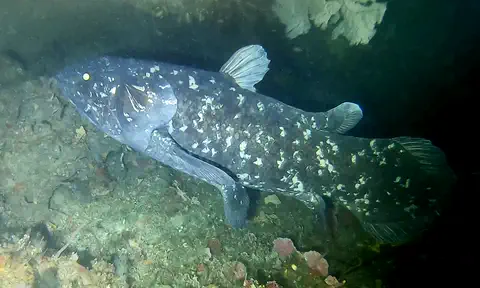
The coelacanth, called a living fossil and once thought extinct for millions of years, inhabits Madagascar's offshore waters.
-
Madagascar's snakes are harmless.
Madagascar's snakes, even the do, which grows 3 to 4 meters long, are harmless; the only large dangerous animals are river crocodiles.
Britannica notes that crocodiles are the island's only large or dangerous animals and that its snakes, including the 3-4 m do, are harmless.
-
A long canal joins lakes along Madagascar's east coast.
On the east coast, a chain of lagoons is linked by the Pangalanes Canal, which is more than 600 kilometers long.
The eastern coastal strip ends in a low coastline of lagoons linked by the Pangalanes (Ampangalana) Canal, more than 600 km long.
-
Some rocks in Madagascar look like a forest of stone.
At Tsingy de Bemaraha, limestone pinnacles up to 100 meters high form a 'forest of sharp stones'.
UNESCO describes Tsingy de Bemaraha as a highly dissected limestone massif crossed by a deep river gorge, with pinnacles up to 100 m forming a 'forest of sharp stones'.
Words to know
- island
- a piece of land with water all around it
- endemic
- found naturally in only one place in the world
- lemur
- a primate, related to monkeys, that lives naturally only in Madagascar
- plateau
- a large area of high, mostly flat land
- rain shadow
- a dry area on the side of mountains or high land away from the rain-bringing wind
- cyclone
- a powerful spinning storm that forms over a warm ocean
- Austronesian
- a large family of languages spoken from Madagascar across Indonesia to the Pacific
Discovery challenge
-
What is the capital city of Madagascar?
Which city is the capital of Madagascar?
Which city, capital of the Merina kingdom from the late 16th century, is Madagascar's capital?
- Toamasina
- Antananarivo
- Antsirabe
Show the answer
Antananarivo
Antananarivo is the capital. It is high on the plateau.
Antananarivo, on the central plateau, is the capital and by far the largest city. Toamasina is the east-coast port.
Antananarivo became the Merina capital toward the end of the 16th century and is now by far the most populous city.
-
Which animals with long tails live in Madagascar's forests?
About 40 kinds of which primates live only in Madagascar?
About 40 species of which primates are indigenous to Madagascar?
- Lemurs
- Penguins
- Kangaroos
Show the answer
Lemurs
Lemurs live in Madagascar's forests.
About 40 kinds of lemurs live on the island. They evolved there while Madagascar was cut off from other land.
Britannica counts about 40 lemur species indigenous to Madagascar, primitive primates that survived and diversified in isolation.
-
Which ocean is all around Madagascar?
In which ocean is Madagascar?
Madagascar lies across the Mozambique Channel from Africa in which ocean?
- The Arctic Ocean
- The Pacific Ocean
- The Indian Ocean
Show the answer
The Indian Ocean
The Indian Ocean is all around Madagascar.
Madagascar is in the Indian Ocean, off the southeastern coast of Africa.
It lies in the southwestern Indian Ocean, separated from Africa by the Mozambique Channel.
-
Why is Madagascar called the Great Red Island?
Why is Madagascar nicknamed the Great Red Island?
What gives Madagascar its colloquial name, the Great Red Island?
- Because of its red soil
- Because of red snow
- Because of red birds
Show the answer
Because of its red soil
Much of Madagascar's soil is red.
Much of the island's rock breaks down into red earth, which gives Madagascar its nickname.
Gneiss on the plateau and east decomposes into red murrum, laterite and red earths, hence the Great Red Island.
-
Which language do most people in Madagascar speak?
What is the national language of Madagascar?
Which Austronesian language is Madagascar's national language?
- Spanish
- Malagasy
- Russian
Show the answer
Malagasy
Most people in Madagascar speak Malagasy.
Malagasy is the national language, and French is widely spoken too.
Malagasy, a standardized form of Merina written in the Latin alphabet, belongs to the Western Malayo-Polynesian branch of Austronesian.
Animals of Madagascar
-
 Watch
3D
Animal
Ring-tailed lemur
The ring-tailed lemur is a primate that lives only on Madagascar, a big island off the coast of Africa. It has a striped tail with 13 black and white rings, sunbathes with its arms spread wide, and lives in groups where the females are in charge.
-
 Watch
Animal
Aye-aye
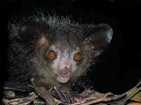
The aye-aye is a lemur from Madagascar, and the largest primate that is active at night. It taps on branches with its long, skinny middle finger, listens with its enormous ears for hidden grubs, then bites into the wood and hooks them out.
-
 Watch
Animal
Panther chameleon
The panther chameleon is a lizard famous for its brilliant colors. It lives on the island of Madagascar, grips branches with tong-shaped feet and a curling tail, looks two ways at once, and catches insects with a lightning-fast tongue. Males change their colors to send messages.
-
 Watch
3D
Animal
West Indian Ocean coelacanth
The West Indian Ocean coelacanth is a large, blue, spotted fish that lives in deep, rocky waters off eastern Africa. Its group was known only from fossils and thought to have died out about 66 million years ago, until a living one was found in South Africa in 1938.
-
 Watch
3D
Animal
Madagascar hissing cockroach
The Madagascar hissing cockroach is one of the largest cockroaches in the world, up to 10 centimeters long, and it has no wings. It lives on the floor of rainforests on the island of Madagascar, where it eats fallen leaves and fruit. It makes a hissing sound by pushing air out of the breathing holes on its body.
Explore next
-
Watch
3D
Animal
Ring-tailed lemur
The ring-tailed lemur is a primate that lives only on Madagascar, a big island off the coast of Africa. It has a striped tail with 13 black and white rings, sunbathes with its arms spread wide, and lives in groups where the females are in charge.
-
Watch
Animal
Aye-aye
The aye-aye is a lemur from Madagascar, and the largest primate that is active at night. It taps on branches with its long, skinny middle finger, listens with its enormous ears for hidden grubs, then bites into the wood and hooks them out.
-
Watch
Animal
Panther chameleon
The panther chameleon is a lizard famous for its brilliant colors. It lives on the island of Madagascar, grips branches with tong-shaped feet and a curling tail, looks two ways at once, and catches insects with a lightning-fast tongue. Males change their colors to send messages.
-
 Watch
 Country
Mozambique
Mozambique stretches along the Indian Ocean coast of southeastern Africa. The great Zambezi River cuts through its middle, its beaches face the island of Madagascar, and parks like Gorongosa are home to elephants and lions. About 35.6 million people lived there in 2025, and Portuguese is the official language.
-
Watch
3D
Animal
West Indian Ocean coelacanth
The West Indian Ocean coelacanth is a large, blue, spotted fish that lives in deep, rocky waters off eastern Africa. Its group was known only from fossils and thought to have died out about 66 million years ago, until a living one was found in South Africa in 1938.
-
Watch
3D
Animal
Madagascar hissing cockroach
The Madagascar hissing cockroach is one of the largest cockroaches in the world, up to 10 centimeters long, and it has no wings. It lives on the floor of rainforests on the island of Madagascar, where it eats fallen leaves and fruit. It makes a hissing sound by pushing air out of the breathing holes on its body.
-
 Watch
 Country
Democratic Republic of the Congo
The Democratic Republic of the Congo, or DR Congo, is the second-largest country in Africa. The mighty Congo River curves through its rainforests, volcanoes rise in the east, and its capital, Kinshasa, is a center of music, fashion and popular culture.
-
 Watch
 Country
Ethiopia
Ethiopia is a country on the Horn of Africa with no coast. Much of it is high, rugged land cut by the Great Rift Valley, it is one of the world's oldest countries, and more than 110 million people live there.
For parents & teachers
What children will learn
- Locate Madagascar in the Indian Ocean and describe its plateau, eastern cliff and western plains.
- Explain how long isolation led to plants and animals found nowhere else.
- Describe Madagascar's languages, farming and crafts without treating its people as one single culture.
- Outline Madagascar's history from settlement around 700 CE to independence in 1960.
Recommended ages: 3 to 17 · About 15 minutes
Talk about it
- Why might an island that has been cut off for millions of years have animals found nowhere else?
- Why do you think the east side of Madagascar gets much more rain than the southwest?
- Madagascar's first settlers came across a huge ocean. What might such a voyage have needed?
Try at home or in class
- On a globe, measure how far Madagascar is from Africa and from Indonesia, and talk about why its language is related to languages so far away.
- Make a 'rain shadow' with a tray of sand piled into a ridge: sprinkle water from one side and see which side stays dry.
Key vocabulary: island, endemic, lemur, plateau, rain shadow, cyclone, Austronesian
Where these facts come from
- Wikidata , Wikimedia Foundation (CC0 1.0)
- Natural Earth vector data , Natural Earth (NACIS) (Public domain)
- UNESCO World Heritage List , UNESCO World Heritage Centre (Linked as a reference; site facts come from Wikidata)
- Madagascar , Encyclopaedia Britannica
- Madagascar: Climate , Encyclopaedia Britannica
- Madagascar: Ethnic groups , Encyclopaedia Britannica
- Madagascar: Daily life and social customs , Encyclopaedia Britannica
- Madagascar: History , Encyclopaedia Britannica
- Madagascar: Political evolution from 1650 to 1810 , Encyclopaedia Britannica
- Madagascar: The First Republic , Encyclopaedia Britannica
- Rainforests of the Atsinanana , UNESCO World Heritage Centre
- Andrefana Dry Forests , UNESCO World Heritage Centre
- Population, total - Madagascar , World Bank
- PlayOwl region table, version 1 , PlayOwl (PlayOwl original data)
- flag-icons 7.5.0 , Panayiotis Lipiridis and contributors (MIT)
- Wikimedia Commons , Wikimedia Foundation (Per file (public domain, CC0, CC BY or CC BY-SA); see each media record)
Checked, not yet human-reviewed. Last updated October 24, 2026. Spotted a mistake? Tell us.