
 Country
North America
Canada
Canada is a very big country in the north of North America. It has tall mountains, many lakes, polar bears and two main languages.
Canada is the second-largest country in the world, stretching across the north of North America from the Atlantic to the Pacific and up into the Arctic. It has the Rocky Mountains, thousands of islands and about 42 million people, who speak English, French and many other languages.
Canada occupies roughly the northern two-fifths of North America and is second only to Russia in area, yet it is one of the most sparsely populated countries. Statistics Canada estimated 41,798,407 people on July 1, 2026, most living within about 300 km of the US border; the country is officially bilingual in English and French.
Photo: Gorgo, public domain, via Wikimedia Commons
Discover Canada
Canada is a very, very big country.
It is in the north of North America. It has snowy mountains, deep forests and blue lakes. The capital city is Ottawa.
Canada is the second-largest country in the world by area, after Russia. It covers roughly the northern two-fifths of North America, about 10 million square kilometers, and it includes thousands of islands, such as Newfoundland in the east and the islands of the Arctic far to the north.
Canada is made of 10 provinces and 3 territories. Even though it is so big, not many people live in much of it. About 42 million people lived there in 2026, and most of them live in the south, fairly close to the border with the United States. The capital is Ottawa.
Canada, the second-largest country in area after Russia, occupies roughly the northern two-fifths of the North American continent, 9,984,670 km² including thousands of adjacent islands such as Newfoundland and those of the Arctic Archipelago. It spans about 52° to 141° W, across six time zones, and about 42° to 83° N.
Britannica calls it one of the most sparsely populated countries in the world: the overwhelming majority of people live within about 300 km of the US border. Statistics Canada estimated the population at 41,798,407 on July 1, 2026. The federation has 10 provinces and 3 territories: Yukon, the Northwest Territories and Nunavut. The capital, Ottawa, is the fourth-largest city; Toronto, Montreal and Vancouver are the three largest.
Cities and famous places
Ottawa is the capital city.
A long canal runs through it. Quebec City is very old. It still has stone walls around it. Toronto, Montreal and Vancouver are big cities.
Ottawa, the capital, lies about 400 kilometers northeast of Toronto and 200 kilometers west of Montreal. The Rideau Canal, built in the early 1800s, runs 202 kilometers from Ottawa to Lake Ontario, and boats still use it along its original route.
Quebec City was founded in the early 1600s by the French explorer Champlain. It is the only city in North America that still has its old ramparts, the strong walls, gates and forts around its oldest part. Toronto and Montreal are Canada's largest cities, and Vancouver, on the Pacific coast, is the third largest.
Ottawa, the national capital and Canada's fourth-largest city, lies about 400 km northeast of Toronto and 200 km west of Montreal, the country's first and second cities; Vancouver, third, is the main trade center facing the Pacific Rim. The Rideau Canal (World Heritage Site, 2007) is an early 19th-century work covering 202 km of the Rideau and Cataraqui rivers from Ottawa to Kingston Harbour. It was built mainly for military purposes when Britain and the United States both sought control of the region, and UNESCO calls it the only canal from that era still working along its original line with most structures intact.
Old Québec (inscribed 1985) was founded by Champlain in the early 17th century; UNESCO describes it as the only North American city to keep its ramparts, with bastions, gates and a Citadel. Its Upper Town on the cliff includes Château Frontenac; together with the Lower Town it is one of the best examples of a fortified colonial city.

Mountains, ice and lakes
Canada has tall mountains called the Rockies.
They have glaciers and lakes. In the far north, there is lots of ice and snow. The tallest mountain is Mount Logan. Big waterfalls roar at Niagara Falls.
In the west, the Canadian Rockies are full of peaks, glaciers, lakes, waterfalls, canyons and caves. Banff, there, was Canada's first national park. At the Burgess Shale fossil site in these parks, rocks hold fossils of soft-bodied sea animals.
In the far southwest of Yukon, Kluane National Park has huge icefields and the country's highest mountain, Mount Logan, 5,959 meters tall. To the north, Canada breaks into thousands of Arctic islands, such as Baffin Island with its fjords. Niagara Falls lies on the border with the United States.
The Canadian Rocky Mountain Parks, inscribed in 1984, join Banff, Jasper, Kootenay and Yoho national parks with three provincial parks in a landscape of peaks, glaciers, lakes, waterfalls, canyons and limestone caves; the Burgess Shale within them is known for fossils of soft-bodied marine animals. Banff was Canada's first national park and is the flagship of the system.
In southwest Yukon, the Icefield Ranges of the St. Elias Mountains fill two-thirds of Kluane National Park and Reserve's interior; Mount Logan (5,959 m) rises there with Mount St. Elias (5,489 m) and others. Kluane is part of a World Heritage complex shared with Alaska that UNESCO says contains the largest non-polar icefield in the world. Britannica describes the country's relief region by region, from the Canadian Shield and the interior plains to the Western Cordillera and the Arctic Archipelago.

Animals of Canada
Polar bears live in the far north of Canada.
Mother bears make dens for their cubs. Beavers build dams with sticks and mud. Moose are very tall and munch on twigs.
Near the town of Churchill, on Hudson Bay, Wapusk National Park protects one of the biggest areas in the world where mother polar bears dig dens to have their cubs. The park sits where the northern forest meets the Arctic tundra.
Beavers are the largest rodents in North America. They build dams of branches, stones and mud across streams, making ponds. Long ago, beaver fur was at the heart of the fur trade. Moose are the largest members of the deer family. The biggest bulls stand about 2 meters tall at the shoulder and eat woody twigs and buds.
Wapusk National Park, 11,475 km² on the transition between boreal forest and Arctic tundra near Churchill, Manitoba, protects one of the largest polar bear maternity denning areas in the world; visits are made only with licensed tour operators.
Beavers (genus Castor) are the largest rodents in North America and Eurasia, with bodies up to 80 cm long and weights of 16–30 kg. Britannica calls them ecosystem engineers: their dams of branches, stones and mud create ponds that can cover many hectares. They were at the heart of the colonial fur trade, which pushed trappers westward. The moose (Alces alces), the largest member of the deer family, lives across northern North America and Eurasia and browses woody twigs and buds; the largest bulls, in Alaska and eastern Siberia, weigh about 600 kg and stand 2 m at the shoulder.

People and languages
About 42 million people live in Canada.
Many people speak English. Many people speak French. First Nations, Métis and Inuit peoples have lived here for a very long time.
Canada has two official languages, English and French. In 2021, about three in four people had English as their first official language and about one in five had French; in Quebec, more than four in five did. Many families came from other countries, and after English and French, Mandarin and Punjabi were the most spoken languages at home.
First Nations, Métis and Inuit are the Indigenous peoples of Canada. In 2021, about 1.8 million Indigenous people lived there, and they reported more than 70 Indigenous languages. Inuit call 50 communities in four northern regions home, and in Nunavut, Canada's newest territory, Inuit have a semiautonomous status, which means they run many of their own affairs.
English and French are the official languages. In the 2021 census, 75.5 percent of people had English as their first official language spoken and 21.4 percent French (82.2 percent in Quebec); 18.0 percent were bilingual in both. One in eight people spoke mainly another language at home, a record; Mandarin and Punjabi were the most common, each with more than half a million speakers.
Statistics Canada counted 1,807,250 Indigenous people in 2021, 5.0 percent of the population: First Nations (58.0 percent of them), Métis (34.5) and Inuit (3.9), the three groups recognized in the Constitution Act, 1982. They include more than 600 First Nations and Inuit living in four regions and 50 communities of Inuit Nunangat, and they reported more than 70 Indigenous languages. Inuit hold a semiautonomous status in Nunavut, Canada's newest territory.

From the first peoples to today
Indigenous peoples have lived in Canada for a very long time.
About 1,000 years ago, Vikings built houses in Newfoundland. Later, people came from France and Britain. Canada became a country in 1867.
Indigenous peoples have lived in the land now called Canada since long before any written records. About 1,000 years ago, Vikings built a small settlement of wooden and turf buildings in Newfoundland, the first known European presence in North America.
In the 1500s and 1600s, France claimed land along the St. Lawrence River, called New France, and Champlain founded Quebec City. Britain later took over New France. In 1867, three colonies joined together to form the Dominion of Canada, and by 1982 Canada had gained full control of its own laws.
Statistics Canada notes that Indigenous communities, cultures and languages have existed since time immemorial in the land now known as Canada, and that colonial history has profoundly affected Indigenous peoples. The Government of Canada says that some 150,000 Indigenous children were removed and separated from their families and communities to attend residential schools, the last federally run one closing in the late 1990s, and in 2008 the Prime Minister apologized to former students on behalf of the government and all Canadians. At L'Anse aux Meadows, on the tip of Newfoundland's Great Northern Peninsula, the remains of an 11th-century Viking settlement, wood-framed peat-turf buildings like those of Norse Greenland and Iceland, are the first evidence of Europeans in North America.
The name Canada comes from the Huron-Iroquois word kanata, a village or settlement. From 1534 to 1763, New France covered French possessions along the St. Lawrence and the Great Lakes, until the British conquest. In 1867 the British North America Act joined Nova Scotia, New Brunswick and Canada (split into Ontario and Quebec) as the Dominion of Canada. Canada became fully self-governing within the British Empire in 1931 and gained the right to amend its own constitution in 1982. Today it is a parliamentary federation whose head of state is the King of Canada, who is also the British monarch.

Canada on the map
Find Canada on the globe.
It is at the top of North America. The United States is to the south. Oceans lie on three sides. In the north, there are many icy islands.
Canada is bordered by three oceans: the Pacific to the west, the Atlantic to the east and the Arctic to the north. Its only land neighbor is the United States, to the south and, in Alaska, to the west. The border between them is 8,890 kilometers long.
Canada stretches across six time zones. Its southernmost point, Middle Island in Lake Erie, is as far south as northern California, while its Arctic islands reach far toward the North Pole.
Britannica describes Canada's boundaries: the Arctic Ocean to the north, Greenland (a self-governing part of the Danish kingdom) to the northeast, the Atlantic to the east, 12 US states to the south, and the Pacific and Alaska to the west. Small Saint-Pierre and Miquelon, a French territory, lies off Newfoundland. The 8,890 km border with the United States, including Alaska, is the country's only land boundary.
Canada spans about 52° to 141° W and 42° to 83° N. Southern Ontario reaches deep into the heart of the United States; Middle Island in Lake Erie lies at the same latitude as northern California. Because Canada lies on great-circle routes between the United States and Europe, many international flights cross it.
- Latitude
- about 42° to 83° north
- Longitude
- about 52° to 141° west, across six time zones
- Border with the United States
- 8,890 km, including Alaska
- Southernmost point
- Middle Island, in Lake Erie
Amazing facts
-
Vikings lived in Canada about 1,000 years ago.
At L'Anse aux Meadows in Newfoundland, people can see the remains of a Viking settlement from the 1000s.
The 11th-century Norse site at L'Anse aux Meadows, with wood-framed peat-turf buildings, is the first evidence of a European presence in North America.
-
Canada's name comes from a word that means village.
The word Canada comes from the Huron-Iroquois word kanata, which means a village or settlement.
Canada derives from Huron-Iroquois kanata (village or settlement); Jacques Cartier used it in the 16th century for the area around today's Quebec City.
-
Quebec City still has its old stone walls.
Quebec City is the only city in North America that has kept its old ramparts, with gates and forts all around.
UNESCO describes Old Québec as the only North American city to have preserved its ramparts, bastions, gates and defensive works.
-
Canada's southern tip is in a lake.
Canada's southernmost point is Middle Island in Lake Erie, as far south as northern California.
Southern Ontario reaches deep into the United States; its southernmost point, Middle Island in Lake Erie, shares the latitude of northern California.
-
Many mother polar bears make dens near Churchill.
Wapusk National Park, near Churchill, protects one of the largest polar bear denning areas in the world.
Wapusk, 11,475 km² between boreal forest and Arctic tundra, protects one of the world's largest polar bear maternity denning areas.
Words to know
- province
- one of the large parts that some countries, like Canada, are divided into, each with its own government
- territory
- in Canada, a large northern region governed in part by the national government
- glacier
- a huge, slow-moving river of ice
- fjord
- a long, narrow inlet of the sea between steep cliffs, carved by a glacier
- Indigenous
- describes the first peoples known to have lived in a place
- official language
- a language a government uses for its laws and services
- rampart
- a thick, strong wall built around a town or fort to protect it
Discovery challenge
-
What is the capital city of Canada?
Which city is the capital of Canada?
Which city, Canada's fourth largest, is the national capital?
- Toronto
- Vancouver
- Ottawa
Show the answer
Ottawa
Ottawa is the capital of Canada.
Ottawa is the capital. Toronto and Montreal are bigger cities.
Ottawa is the capital and fourth-largest city; Toronto, Montreal and Vancouver are larger.
-
Only one country is bigger than Canada. Which one?
Canada is the second-largest country. Which country is larger?
Which country is the only one with a larger area than Canada?
- Russia
- United States
- China
Show the answer
Russia
Russia is the only country bigger than Canada.
Russia is the largest country in the world, and Canada is second.
Canada is second in area only to Russia, occupying roughly the northern two-fifths of North America.
-
Which two languages are official in Canada?
What are Canada's two official languages?
Canada is officially bilingual. In which two languages?
- English and Spanish
- English and French
- French and German
Show the answer
English and French
English and French are the official languages.
English and French are official. French is the main language for most people in Quebec.
English and French are official; in 2021, 75.5 percent had English and 21.4 percent French as first official language.
-
Which animal builds dams with sticks and mud?
Which Canadian animal builds dams of branches, stones and mud?
Which rodent, called an ecosystem engineer, builds dams that create ponds?
- Moose
- Beaver
- Polar bear
Show the answer
Beaver
Beavers build dams with sticks and mud.
Beavers build dams of branches, stones and mud, and the water behind them makes a pond.
Beavers, North America's largest rodents, build dams that create ponds covering many hectares.
-
Long ago, Vikings built houses in Canada. Where?
Where did Vikings build a settlement about 1,000 years ago?
Which Newfoundland site holds the remains of an 11th-century Norse settlement?
- L'Anse aux Meadows
- Quebec City
- Vancouver
Show the answer
L'Anse aux Meadows
They built houses at L'Anse aux Meadows, by the sea in Newfoundland.
L'Anse aux Meadows, in Newfoundland, has the remains of a Viking settlement from the 1000s.
L'Anse aux Meadows, a World Heritage Site since 1978, is the first evidence of a European presence in North America.
Places to discover in Canada
-
 Watch
City
Ottawa
Ottawa is the capital of Canada. It stands where three rivers meet, beside the Ottawa River, which divides the provinces of Ontario and Quebec. It began as a lumber town called Bytown, became the capital in 1857, and had 1,017,449 people at the 2021 census.
-
 Watch
Landmark
CN Tower
The CN Tower in Toronto is 553 meters tall. It was built between 1973 and 1975 so that radio and TV signals could reach over the city's new tall buildings. For more than 30 years it was the tallest freestanding structure in the world, and today more than two million people visit it every year.
-
 Watch
Natural wonder
Niagara Falls
Niagara Falls is a set of three waterfalls on the Niagara River, which flows from Lake Erie to Lake Ontario across the border between Canada and the United States. About 500 waterfalls in the world are taller, but Niagara is famous for its height together with the enormous amount of water that pours over it.
-
Watch
Natural wonder
Rocky Mountains
The Rocky Mountains, or Rockies, stretch about 4,800 kilometers from northern Canada to New Mexico in the United States. They include more than 100 separate ranges, and their highest peak, Mount Elbert in Colorado, is 4,399 meters tall. Glaciers carved their peaks and valleys, and famous parks such as Banff, Jasper and Yellowstone protect their lakes, hot springs and wildlife.
-
 Watch
Natural wonder
Lake Superior
Lake Superior is the largest of North America's five Great Lakes, shared by the United States and Canada. It covers about 82,100 square kilometers, reaches 406 meters deep, and holds more water than the other four Great Lakes put together. It sits in an ancient crack in the continent that glaciers scooped out.
-
Watch
Natural wonder
Banff National Park
Banff National Park lies in the Rocky Mountains of Alberta, in western Canada. It began in 1885 around a group of hot springs, which makes it Canada's first national park. Today it covers 6,641 square kilometers of jagged peaks, glaciers, forests and turquoise lakes such as Lake Louise and Moraine Lake, and it is home to grizzly bears, wolves, elk and many more animals.
Animals of Canada
-
Watch
Animal
Polar bear
The polar bear is a huge bear that lives on the frozen sea of the Arctic. Thick fur and a layer of fat keep it warm, its amazing nose finds seals under the snow, and it can swim for many hours. It needs sea ice to hunt, so a warming Arctic is a big problem for it.
-
 Watch
3D
Animal
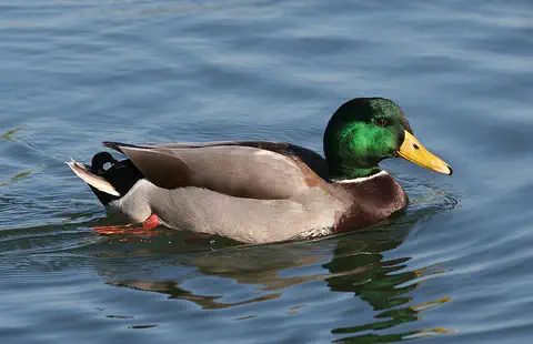
Mallard
The mallard is perhaps the most familiar duck in the world, found on ponds, lakes, rivers and city parks across North America, Europe and Asia. Males have glossy green heads; females are mottled brown. Almost all farm ducks are descended from mallards.
-
 Watch
3D
Animal
Eastern tiger swallowtail
The eastern tiger swallowtail is a large butterfly of eastern North America. Males are yellow with black tiger stripes, while many females are dark, which helps them look like a bad-tasting butterfly. Its caterpillars disguise themselves as bird droppings, then turn green with big fake eyes.
-
 Watch
Animal
Chinook salmon
The Chinook salmon, also called the king salmon, is the largest Pacific salmon. It hatches in a cold river, travels to the ocean to feed and grow for a few years, then swims back up its home river to lay eggs.
-
 Watch
3D
Animal
Atlantic cod
The Atlantic cod is a large, speckled fish of the cold North Atlantic. It has a whisker-like barbel on its chin and three fins along its back. For hundreds of years people have caught cod for food, so many that some cod populations crashed and are still being rebuilt today.
-
 Watch
Animal
Canada lynx
The Canada lynx is a wild cat of the snowy northern forests of Canada and Alaska. Its huge, furry paws work like snowshoes, and it depends on one animal above all, the snowshoe hare. When hares are plentiful, lynx do well; when hares become scarce, lynx have a hard time too.
-
 Watch
Animal
Muskox
Muskoxen are shaggy Arctic grazers with long coats that nearly reach the ground and a super-warm underwool called qiviut. Herds protect their calves by standing in a ring with their horns facing out. Despite the name, they are more closely related to goats and sheep than to oxen.
-
 Watch
Animal
Gray whale
The gray whale is a baleen whale of the North Pacific Ocean. It sucks up mud from the seafloor to catch tiny animals, and it makes one of the longest yearly journeys of any mammal: about 16,000 kilometers there and back between Arctic feeding seas and shallow lagoons in Mexico.
-
 Watch
3D
Animal
Narwhal
The narwhal is a toothed whale of the icy Arctic Ocean. Most males have a long, spiral tusk that is really a tooth growing forward out of the front of the jaw, and it can be up to about 3 meters long. Narwhals dive deep under the sea ice to catch fish, squid and shrimp.
-
 Watch
Animal
Ochre sea star
The ochre sea star lives on wave-washed rocky shores along the Pacific coast of North America. It can be purple, orange or brown, and it pries open mussels to eat them with a stomach it pushes out of its body. It is so important to its shore that scientists call it a keystone species.
-
 Watch
3D
Animal
Great blue heron
The great blue heron is the largest heron in North America. It wades slowly through marshes, rivers and ponds, or stands as still as a statue, then strikes like lightning with its dagger-shaped bill to catch fish, frogs and even small mammals.
-
 Watch
Animal
Common loon
The common loon is a big diving bird of northern lakes. In summer it wears a black head, a striped white necklace and a checkered back. It chases fish underwater, calls with eerie wails and yodels, and spends the winter on the coast.
Explore next
-
Watch
Natural wonder
Banff National Park
Banff National Park lies in the Rocky Mountains of Alberta, in western Canada. It began in 1885 around a group of hot springs, which makes it Canada's first national park. Today it covers 6,641 square kilometers of jagged peaks, glaciers, forests and turquoise lakes such as Lake Louise and Moraine Lake, and it is home to grizzly bears, wolves, elk and many more animals.
-
Watch
Natural wonder
Niagara Falls
Niagara Falls is a set of three waterfalls on the Niagara River, which flows from Lake Erie to Lake Ontario across the border between Canada and the United States. About 500 waterfalls in the world are taller, but Niagara is famous for its height together with the enormous amount of water that pours over it.
-
Watch
Natural wonder
Rocky Mountains
The Rocky Mountains, or Rockies, stretch about 4,800 kilometers from northern Canada to New Mexico in the United States. They include more than 100 separate ranges, and their highest peak, Mount Elbert in Colorado, is 4,399 meters tall. Glaciers carved their peaks and valleys, and famous parks such as Banff, Jasper and Yellowstone protect their lakes, hot springs and wildlife.
-
Watch
City
Ottawa
Ottawa is the capital of Canada. It stands where three rivers meet, beside the Ottawa River, which divides the provinces of Ontario and Quebec. It began as a lumber town called Bytown, became the capital in 1857, and had 1,017,449 people at the 2021 census.
-
Watch
Animal
Polar bear
The polar bear is a huge bear that lives on the frozen sea of the Arctic. Thick fur and a layer of fat keep it warm, its amazing nose finds seals under the snow, and it can swim for many hours. It needs sea ice to hunt, so a warming Arctic is a big problem for it.
-
Watch
3D
Animal
Mallard
The mallard is perhaps the most familiar duck in the world, found on ponds, lakes, rivers and city parks across North America, Europe and Asia. Males have glossy green heads; females are mottled brown. Almost all farm ducks are descended from mallards.
-
Watch
3D
Animal
Eastern tiger swallowtail
The eastern tiger swallowtail is a large butterfly of eastern North America. Males are yellow with black tiger stripes, while many females are dark, which helps them look like a bad-tasting butterfly. Its caterpillars disguise themselves as bird droppings, then turn green with big fake eyes.
-
Watch
Animal
Chinook salmon
The Chinook salmon, also called the king salmon, is the largest Pacific salmon. It hatches in a cold river, travels to the ocean to feed and grow for a few years, then swims back up its home river to lay eggs.
For parents & teachers
What children will learn
- Locate Canada, its three oceans and its one land neighbor.
- Describe the Rockies, the Arctic north and why most people live in the south.
- Recognize First Nations, Métis and Inuit, and Canada's English, French and many other languages.
- Outline Canada's history from the first peoples and L'Anse aux Meadows to Confederation (1867) and 1982.
Recommended ages: 3 to 17 · About 15 minutes
Talk about it
- Why do you think most people in Canada live close to the southern border?
- What would it be like to go to school in two languages?
- How does a beaver dam change a stream for other animals?
Try at home or in class
- On a map or globe, count the time zones from Newfoundland to Yukon.
- Build a small dam of twigs, pebbles and mud in a tray of water and watch a pond form behind it.
Key vocabulary: province, territory, glacier, fjord, Indigenous, official language, rampart
Where these facts come from
- Wikidata , Wikimedia Foundation (CC0 1.0)
- Natural Earth vector data , Natural Earth (NACIS) (Public domain)
- UNESCO World Heritage List , UNESCO World Heritage Centre (Linked as a reference; site facts come from Wikidata)
- Population estimates, quarterly (Table 17-10-0009-01) , Statistics Canada
- Indigenous population continues to grow and is much younger than the non-Indigenous population (The Daily, 2021 Census) , Statistics Canada
- While English and French are still the main languages spoken in Canada, the country's linguistic diversity continues to grow (The Daily, 2021 Census) , Statistics Canada
- Land and freshwater area, by province and territory (Canada Year Book 2012) , Statistics Canada
- Indian Residential Schools Settlement Agreement , Crown-Indigenous Relations and Northern Affairs Canada
- Canada , Encyclopaedia Britannica
- Canada: Land , Encyclopaedia Britannica
- Banff National Park , Parks Canada
- Mountaineering, Kluane National Park and Reserve , Parks Canada
- Wapusk National Park , Parks Canada
- Canadian Rocky Mountain Parks , UNESCO World Heritage Centre
- Kluane / Wrangell-St. Elias / Glacier Bay / Tatshenshini-Alsek , UNESCO World Heritage Centre
- L'Anse aux Meadows National Historic Site , UNESCO World Heritage Centre
- Historic District of Old Québec , UNESCO World Heritage Centre
- Rideau Canal , UNESCO World Heritage Centre
- Beaver , Encyclopaedia Britannica
- Moose , Encyclopaedia Britannica
- PlayOwl region table, version 1 , PlayOwl (PlayOwl original data)
- flag-icons 7.5.0 , Panayiotis Lipiridis and contributors (MIT)
- Wikimedia Commons , Wikimedia Foundation (Per file (public domain, CC0, CC BY or CC BY-SA); see each media record)
Checked, not yet human-reviewed. Last updated October 24, 2026. Spotted a mistake? Tell us.
Picture credits
- Photo: Gorgo, public domain, via Wikimedia Commons · source
- Photo: Wilfredor, CC BY-SA 4.0, via Wikimedia Commons · source · license
- Photo: Jsayre64, CC BY-SA 4.0, via Wikimedia Commons · source · license
- Photo: Arturo de Frias Marques, CC BY-SA 4.0, via Wikimedia Commons · source · license
- Photo: Sebastian Kasten, CC BY-SA 3.0, via Wikimedia Commons · source · license
- Photo: Photo: Gordon Leggett, CC BY-SA 4.0, via Wikimedia Commons · source · license
- Photo: Josh Campbell, CC BY 2.0, via Wikimedia Commons · source · license
- Photo: TravelingOtter from Houston, Texas, USA, CC BY 2.0, via Wikimedia Commons · source · license
- Photo: Vlad Podvorny, CC BY 2.0, via Wikimedia Commons · source · license
- Photo: Ryan Hagerty, public domain, via Wikimedia Commons · source
- Photo: Bobak Ha'Eri, CC BY-SA 2.5, via Wikimedia Commons · source · license
- Photo: Quintin Soloviev, CC BY 4.0, via Wikimedia Commons · source · license