
Natural wonder Africa
Orange River
The Orange River starts high in the mountains of Lesotho. It flows west across dry land all the way to the Atlantic Ocean.
The Orange River rises in the Drakensberg-Maloti highlands, where it is called the Senqu, and runs west for about 2,200 kilometers through South Africa and along the edge of Namibia's desert to the Atlantic Ocean. On the way it thunders over the 56-meter Augrabies Falls.
The Senqu rises in the Lesotho highlands, where rivers have cut gorges more than 1,000 m deep through basalt; as the Orange it crosses semi-arid and arid South Africa for about 2,200 km (ESA) to the Atlantic, dropping 56 m at Augrabies Falls into a gorge about 240 m deep.
Photo: Martin Cígler, CC BY-SA 3.0, via Wikimedia Commons
Discover the Orange River
The Orange River is a long river in southern Africa. It flows from high mountains to the sea.
In this photo, blue water rushes over rocks. Green reeds grow in the river, and dry hills rise on both sides.
The European Space Agency (ESA) says the Orange River runs west for about 2,200 kilometers, from the Drakensberg mountains to the Atlantic Ocean. In its last stretch it flows between South Africa and Namibia, past the sand dunes of the Namib Desert.
This photo by Martin Cígler, taken on 17 August 2014, shows the Orange River valley: the river splits around reedy islands and rocks, with bare, dry hills on either side.
ESA's Envisat feature gives the Orange River a westward course of about 2,200 km from the Drakensberg to the Atlantic; NASA's Earth Observatory says it snakes more than 2,000 km across South Africa. The Freshwater Ecoregions of the World (FEOW) account traces it from the Senqu's headwaters in Lesotho's highlands.
The hero photo, by Martin Cígler (17 August 2014, via Panoramio), is titled in Czech 'Údolí řeky Orange' ('Orange River valley'): braided channels, reed beds and rapids between bare, rocky hills, with distant peaks.
- Length
- about 2,200 km (ESA)
- Source
- the Drakensberg-Maloti highlands (as the Senqu)
- Mouth
- the Atlantic Ocean
- Augrabies Falls
- 56 m high
Cutting through rock
High in the mountains, small streams join to make the river.
Over a very long time, the water cut deep valleys into the rock.
The Orange begins in the highlands of Lesotho, where it is called the Senqu. FEOW explains that these mountains are made of basalt, rock from lava that poured out about 180 million years ago, lying on top of softer sandstone. Fast streams have cut gorges through the basalt and into the sandstone, and some valleys are more than 1,000 meters deep.
Far downstream, below Augrabies Falls, the river runs through a gorge about 240 meters deep and 18 kilometers long.
FEOW describes the Drakensberg-Maloti Highlands as heavily dissected by small streams, most of them headwaters of the Senqu/Orange. The peaks above 2,300 m are basalts extruded about 180 million years ago over horizontal sedimentary strata topped by soft sandstones; the rivers have eroded gorges through the basalts into the sandstones, and the cliffs and valleys can be in excess of 1,000 m deep. Streams drop up to 1,200 m in 60-70 km before slowing and widening in the lowlands.
Downstream in South Africa, South African Tourism describes the river cascading 56 m at Augrabies Falls into a gorge about 240 m deep that runs for about 18 km; the park's rock formations include Moon Rock, a weathered granite dome rising 30 m.
From mountains to desert
The river starts in cold, wet mountains. It ends in a hot, dry desert.
At the sea, sand sometimes blocks its way.
After the highlands, the Senqu flows southwest through the lowlands of Lesotho. In South Africa it is called the Orange, and it flows west through dry and very dry land.
NASA says its last stretch is a bit like a moat the Namib Desert can't cross: the wind blows sand and dust onto the river, which carries it out to sea. ESA notes that sand bars sometimes block the river's way into the Atlantic Ocean.
FEOW traces the Senqu from the northeast highlands, joined by tributaries such as the Senqunyane and Malibamatso, southwest through Lesotho's lowlands; as the Orange it flows westward through semi-arid and arid lands to the Atlantic.
NASA's 2005 Landsat feature on the last 100 km describes the river separating the dunes of the lower Namib Desert from the rocky landscape of northwestern Namaqualand, and calls it a moat the desert can't cross: winds that blow generally north to south pick up loose sand and dust, and the dust settles on the river, which carries it to sea. ESA adds that sand bars sometimes block its access to the ocean, so it is often called a river mouth rather than a true estuary.
Life along a desert river
High in the mountains lives a rare fish, the Maloti minnow.
Near the waterfall, springbok, kudu and giraffes live in the dry land.
In the highlands, FEOW says the Maloti minnow is found only in six high-altitude streams that feed the Orange, and describes it as critically endangered.
Around Augrabies Falls, South African Tourism lists springbok, gemsbok, kudu, klipspringer and giraffes, many most active at night when it is cooler, plus quiver trees and Verreaux's eagles. NASA says that each August to October, spring rains bring wildflowers to the dry land around the river's last stretch.
FEOW names one endemic fish in the Drakensberg-Maloti Highlands: the Maloti minnow (Pseudobarbus quathlambae), known only from six high-altitude tributaries of the Orange and described as critically endangered by habitat degradation and alteration and by competition with and predation by alien trout. Its high-altitude wetlands (bogs, sponges, tarns) occur elsewhere in southern Africa only in limited parts of the Eastern Cape.
In Augrabies Falls National Park, South African Tourism lists springbok, gemsbok, kudu, klipspringer, African wild cat, spotted genet and giraffe, rarely seen leopards and breeding Verreaux's eagles. Along the river's last 100 km, NASA notes a brief spring rainy season from August to October that brings wildflowers, while at other times of the year moisture may come only from Atlantic fog.
Visiting safely
Near the river it can be very hot in summer and cold on winter nights.
Near water, wear a life jacket and stay with your grown-up.
South African Tourism says summer days at Augrabies Falls National Park average a searing 40 degrees Celsius, while winter nights often drop below freezing. It suggests visiting in autumn (April and May) or spring (September and October), with a sun hat, sunblock and warm clothes for the nights.
The US Centers for Disease Control and Prevention (CDC) says children should wear life jackets for all activities in and around natural water, such as rivers.
South African Tourism describes Augrabies as a low-rainfall area with extreme temperature swings: summer daytime averages of about 40 °C and winter nights often below zero. It recommends April-May and September-October and advises sun protection and layers. Activities include hiking trails and canoeing on the river.
The CDC advises that life jackets reduce the risk of drowning while boating for people of all ages and swimming abilities, that children should wear them for all activities in and around natural water, and that foam or air-filled toys are not safety devices.
Amazing facts
-
In the mountains, the river has a different name: the Senqu.
In Lesotho's highlands, the upper Orange River is called the Senqu.
FEOW writes it as the Senqu/Orange: the Senqu rises in Lesotho's northeast highlands and is known as the Orange in South Africa.
-
Wind blows desert sand into the river, and the river carries it to the sea.
NASA calls the Orange River a moat that the Namib Desert can't cross: the river carries the desert's sand and dust out to sea.
NASA's 2005 feature notes that north-to-south winds pick up Namib sand and dust, and the dust settles on the river, which carries it to the Atlantic, like a moat the desert cannot cross.
-
In the park around Augrabies Falls, a rock called Moon Rock rises 30 meters.
In Augrabies Falls National Park stands Moon Rock, a weathered granite dome that rises 30 meters above the park.
South African Tourism describes Moon Rock in Augrabies Falls National Park as a weathered granite dome rising 30 m above the semi-desert.
Words to know
- basalt
- a dark rock that forms when lava cools
- gorge
- a deep, narrow valley with steep rocky sides, often cut by a river
- headwaters
- the streams where a river begins
- sand bar
- a ridge of sand built up by water, which can block a river's way into the sea
- endemic
- found naturally in only one place
Discovery challenge
-
Which ocean does the Orange River flow into?
Which ocean does the Orange River reach at its mouth?
Into which ocean does the Orange River empty?
- The Atlantic Ocean
- The Indian Ocean
- The Pacific Ocean
Show the answer
The Atlantic Ocean
The Atlantic Ocean.
The Atlantic Ocean, after running west for about 2,200 kilometers.
The Atlantic, though sand bars sometimes block its access to the sea.
-
What is the river called high in the mountains of Lesotho?
What name does the upper Orange River have in Lesotho's highlands?
By what name does FEOW call the Orange in Lesotho's highlands?
- The Senqu
- The Limpopo
- The Zambezi
Show the answer
The Senqu
The Senqu.
The Senqu. In South Africa it is called the Orange.
The Senqu (FEOW: Senqu/Orange).
-
How far does the water drop at Augrabies Falls?
How high are Augrabies Falls on the Orange River?
What drop does South African Tourism give for Augrabies Falls?
- 56 meters
- 5 meters
- 560 meters
Show the answer
56 meters
56 meters.
56 meters, into a gorge about 240 meters deep.
56 m, into a gorge about 240 m deep and 18 km long.
-
What sometimes blocks the river where it meets the sea?
What sometimes blocks the Orange River's way into the Atlantic Ocean?
What does ESA say sometimes blocks the river's access to the sea, so that it is often called a river mouth rather than a true estuary?
- Sand bars
- Ice
- A coral reef
Show the answer
Sand bars
Sand bars.
Sand bars sometimes block it.
Sand bars sometimes block its access to the sea.
-
Which rare fish lives only in high mountain streams of the Orange?
Which fish does FEOW say is found only in six high streams that feed the Orange?
Which critically endangered fish is the one endemic of the Drakensberg-Maloti Highlands, according to FEOW?
- The Maloti minnow
- The great white shark
- The Atlantic salmon
Show the answer
The Maloti minnow
The Maloti minnow.
The Maloti minnow, which is critically endangered.
Pseudobarbus quathlambae, threatened by habitat change and alien trout.
Nearby places
-
 Watch
Natural wonder
Tugela Falls
Tugela Falls, in the Drakensberg mountains of South Africa, drops 948 meters in a series of five cascades. South African Tourism calls it the highest waterfall in Africa and second only to Angel Falls in Venezuela.
-
 Watch
City
Maseru
Maseru is the capital of Lesotho, a country completely surrounded by South Africa. It was founded in 1869 on a hill above a crossing place on the Caledon River, which now forms the border. At the 2016 census, 343,541 people lived in the city.
-
 Watch
City
Durban
Durban is a port city on the Indian Ocean coast of South Africa, in KwaZulu-Natal. Universalis calls its harbor the largest port in South Africa. The 2011 census counted 2,786,046 people in the Durban urban area.
-
 Watch
City
Bloemfontein
Bloemfontein is the capital of the Free State province of South Africa. It is also called the country's judicial capital, because the Supreme Court of Appeal meets there. It began in 1846 as a small British post on the grassy plains.
-
 Watch
City
Benoni
Benoni is a town in South Africa, near Johannesburg, in a region called the Witwatersrand. The encyclopedia Larousse names gold mines and electrical-machine making in Benoni. South Africa's 2011 census counted 158,777 people in the town.
-
 Watch
City
Johannesburg
Johannesburg is South Africa's most populous city, high on the country's central plateau. It grew very fast after gold was discovered in the Witwatersrand in 1886. Today it is the capital of Gauteng province, and the 2022 census counted 4,803,262 people in the City of Johannesburg.
-
 Watch
Landmark
Cradle of Humankind
The Cradle of Humankind is a landscape of grassy hills and limestone caves near Johannesburg, South Africa. Its caves, such as Sterkfontein, Swartkrans and Kromdraai, have held fossils of early human relatives, other animals and stone tools. It became a UNESCO World Heritage Site in 1999.
-
 Watch
City
Maputo
Maputo is the capital of Mozambique, on a bay of the Indian Ocean in the far south of the country. Mozambique's statistics office projected 1,133,200 people in Maputo City in 2023. Until 1976 the city was called Lourenço Marques.
Explore next
-
 Watch
Natural wonder
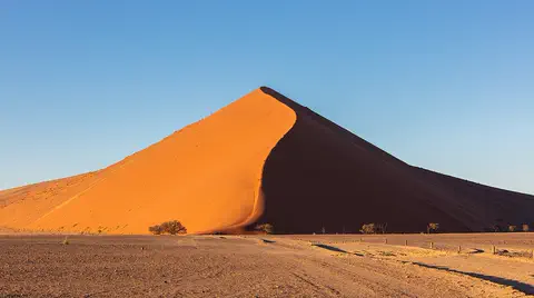
Namib
The Namib is a cool desert that runs for about 1,900 kilometers along Africa's Atlantic coast, from Angola through Namibia into South Africa. It gets almost no rain, but cold ocean water makes thick fog that drifts inland. UNESCO says its Namib Sand Sea is the only coastal desert in the world with huge dune fields influenced by fog.
-
 Watch
Natural wonder
Kalahari Desert
The Kalahari is a giant sandy plain in southern Africa, covering almost all of Botswana and parts of Namibia and South Africa. It stretches about 1,600 kilometers from north to south. Its southwest is a true desert, with long red dunes, while its north is green with woodlands and even has a huge swamp, the Okavango Delta.
-
 Watch
 Country
South Africa
South Africa is the southernmost country in Africa, with the Atlantic Ocean on one side and the Indian Ocean on the other. A high plateau covers most of it, about 63.5 million people (2026) live there, and it has 12 official languages and three capital cities.
-
Watch
 Country
Lesotho
Lesotho is a kingdom of tall mountains and narrow valleys, completely surrounded by South Africa. Two-thirds of the country is mountains, and the Orange River, one of southern Africa's biggest rivers, begins in its highlands. Many people wear colorful blankets as cloaks. The 2016 census counted about 2 million people.
-
Watch
 Country
Namibia
Namibia lies on the southwestern coast of Africa. The Namib, a desert of huge dunes kept alive by sea fog, runs along its coast, a high plateau with farms and wildlife fills its middle, and the dry Kalahari lies to the east. Namibia became independent in 1990.
-
 Watch
Natural wonder
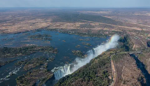
Victoria Falls
Victoria Falls, on the Zambezi River between Zambia and Zimbabwe, is about 1,708 meters wide and up to 108 meters deep. UNESCO calls it the largest curtain of falling water in the world, and its spray can be seen from tens of kilometers away.
-
 Watch
Natural wonder
Sahara
The Sahara fills almost all of northern Africa. Britannica calls it the largest hot desert in the world: about 4,800 kilometers from east to west and about 8.6 million square kilometers in all. Only about a quarter of it is sand dunes; the rest is gravel plains, rocky plateaus and mountains.
-
 Watch
Natural wonder
Mount Kilimanjaro
Mount Kilimanjaro, in northeastern Tanzania, is what UNESCO calls the highest mountain in Africa: its top is 5,895 meters high. It is a huge volcanic mountain standing alone above the plains, and as you climb it you pass through farms, forest, moorland and high alpine desert to its icy top.
For parents & teachers
What children will learn
- Trace the Orange River from Lesotho's highlands west to the Atlantic Ocean.
- Explain how rivers cut gorges through layers of rock.
- Describe how the river meets the Namib Desert near its mouth.
- Know how to stay safe in hot, dry places and near rivers.
Recommended ages: 3 to 17 · About 15 minutes
Talk about it
- Why might a river keep the same water but have different names in different places?
- How can a river carry desert sand all the way to the sea?
- Why might a fish that lives in only six streams be at risk?
Try at home or in class
- Pack damp sand in a tray, lay a thin layer of clay on top, then pour a slow trickle of water across it: watch the water cut through the top layer into the softer sand below.
- Find the Orange River on a map of southern Africa and trace it from the mountains of Lesotho to the Atlantic coast.
Key vocabulary: basalt, gorge, headwaters, sand bar, endemic
Where these facts come from
- Wikidata , Wikimedia Foundation (CC0 1.0)
- Earth from Space: Orange River , European Space Agency
- Orange River, South Africa , NASA Earth Observatory
- The Orange River separates the nations of Namibia and South Africa , NASA
- Drakensberg - Maloti Highlands (ecoregion 574) , Freshwater Ecoregions of the World
- The thundering beauty of a desert river: Augrabies Falls National Park , South African Tourism
- Preventing Drowning , US Centers for Disease Control and Prevention
- File:Údolí řeky Orange - panoramio.jpg , Wikimedia Commons
- Natural Earth vector data , Natural Earth (NACIS) (Public domain)
- Wikimedia Commons , Wikimedia Foundation (Per file (public domain, CC0, CC BY or CC BY-SA); see each media record)
Checked, not yet human-reviewed. Last updated November 1, 2026. Spotted a mistake? Tell us.