
 Country
Africa
South Africa
South Africa is at the very bottom of Africa, between two oceans. It has lions and elephants, a flat-topped mountain and many languages.
South Africa is the southernmost country in Africa, with the Atlantic Ocean on one side and the Indian Ocean on the other. A high plateau covers most of it, about 63.5 million people (2026) live there, and it has 12 official languages and three capital cities.
South Africa, the southernmost country on the African continent, is mostly a high plateau rimmed by the Great Escarpment, with the Drakensberg in the east and fold mountains around Cape Town. Its roughly 63.5 million people (Stats SA, mid-2026) speak 12 official languages. The land has been home to human ancestors for some three million years, and apartheid, legal racial segregation, ended in 1994.
Photo: Diego Delso, CC BY-SA 4.0, via Wikimedia Commons
Discover South Africa
South Africa is at the very bottom of Africa.
One ocean is on its west side. Another ocean is on its east side. It has high, flat land and tall mountains. People there speak many languages.
South Africa is the country at the southern tip of Africa. Its coast is washed by the Atlantic Ocean to the southwest and the Indian Ocean to the southeast. Inside, most of the land is a high, wide plateau, and a long wall of mountains called the Great Escarpment separates it from the narrow lands by the sea.
About 63.5 million people lived in South Africa in 2026. The country has 12 official languages, and it has three capital cities, each with a different job: Pretoria, Cape Town and Bloemfontein.
South Africa covers about 1,221,000 square kilometers at the southern end of the continent. Britannica describes a plateau that covers the largest part of the country, made almost entirely of very old Karoo System rock formed between about 320 and 200 million years ago, and separated from the lower lands around it by the Great Escarpment. The plateau is highest in the east, above 2,400 m in the Lesotho region, and falls to about 600 m in the sandy Kalahari in the west.
Statistics South Africa estimated the mid-2026 population at about 63.5 million, with Gauteng the most populous province (more than 16.2 million). Twelve languages are official under the 1996 constitution (since amended). Three cities serve as capitals: Pretoria (executive), Cape Town (legislative) and Bloemfontein (judicial).
Cities and famous places
Cape Town sits between a mountain and the sea.
The mountain has a flat top, like a table. Johannesburg is a big city with tall buildings. Long ago, people dug for gold there.
Cape Town, the site of the first European settlement in South Africa, began in 1652 as a stop where Dutch ships could take on fresh supplies. Its houses spread over the slopes of Table Mountain, a mountain with a flat top, and along the bay.
Johannesburg, the largest urban area, was founded in 1886 after gold was found under the ground. It sits in Gauteng, whose name is a Sotho word meaning "Place of Gold." Durban is a port on the Indian Ocean. Near Johannesburg, caves in the Cradle of Humankind hold fossils of very early human relatives.
Cape Town, the legislative capital, is called the country's "mother city" because it was the site of the first European settlement: in 1652 the Dutch East India Company set up a refreshment station for its ships on Table Bay. Table Mountain (1,086 m) owes its flat top to nearly horizontal sandstone layers exposed by erosion; its "Tablecloth" cloud forms quickly when the wind is from the southeast.
Johannesburg, founded in 1886 after the discovery of gold, stands at 1,740 to 1,810 m on the Witwatersrand, a string of low ridges whose gold-bearing reef once supplied more than 40 percent of the world's yearly gold; the municipality had 4,803,262 people in 2022. Durban is a major industrial port. The fossil caves of Sterkfontein, Swartkrans and Kromdraai (World Heritage, 1999), later extended to Taung and Makapan, hold hominin fossils, and Robben Island, a prison for political prisoners in the late 20th century, was inscribed the same year.

Mountains, plateau and coast
South Africa has tall mountains called the Drakensberg.
A river falls down their cliffs in a long waterfall. Much of the country is dry. Many flowers grow near Cape Town.
The Drakensberg, the main mountain range of southern Africa, stretches about 1,125 kilometers and rises to more than 3,400 meters. There the Tugela River tumbles down a series of waterfalls that drop 948 meters in all.
Most of South Africa is fairly dry, and rain falls less and less from east to west: the coast of KwaZulu-Natal gets more than 1,000 millimeters a year, but Alexander Bay on the west coast gets less than 50. The southwestern Cape has a special kind of shrubland called fynbos and is home to many of the country's 20,000 kinds of flowering plants.
The Great Escarpment, known in part as uKhahlamba ("Barrier of Spears") and the Drakensberg, is the longest continuous landform in the country. The country's highest point is Mafadi, on the border between KwaZulu-Natal and Lesotho: the national survey maps give 3,446 m or 3,450 m, and a GPS survey by the Mountain Club of South Africa in 2002 measured 3,451 m (Britannica names Njesuthi, 3,408 m, instead). The range rises to more than 3,475 m, with its highest stretch in eastern and southern Lesotho. The Tugela falls from the Mont-aux-Sources plateau in a series of cascades totaling 948 m, and the Orange River and its tributaries drain about 852,000 km² to the Atlantic.
The country is generally semiarid: more than one-fifth receives under 200 mm of rain a year, almost half 200 to 600 mm, and only about 6 percent more than 1,000 mm. The cold Benguela Current cools the west coast and adds to the dryness of the west, while the warm Agulhas and Mozambique currents keep the east and southeast coasts warmer. Temperatures generally fall from east to west: Durban averages 21 °C and Port Nolloth, at a similar latitude on the west coast, 14 °C. The Cape Floral Region, inscribed by UNESCO in 2004, is one of the world's great centers of land biodiversity, its fynbos adapted to a Mediterranean climate and periodic fires.

Animals of South Africa
Lions, elephants and zebras live in South Africa.
Big rhinos and hippos live there too. Most of the big animals live in parks. Hundreds of kinds of birds fly there.
South Africa has more than 200 kinds of mammals, including lions, leopards, elephants, rhinoceroses, hippos, baboons, zebras and many kinds of antelope. Today most of the large animals live in wildlife reserves.
Kruger National Park, the largest park, is about 320 kilometers long. Elephants, lions, leopards, cheetahs, buffalo, rhinos, zebras, wildebeests and impalas live there. On the coast of KwaZulu-Natal, a protected wetland is home to Nile crocodiles and many hippos, and more than 800 kinds of birds live in the country.
Britannica counts more than 200 mammal species, from lions, elephants, rhinoceroses and hippopotamuses to mongooses and caracals, and more than 800 bird species, including the bearded vulture, bald ibis and black eagle. Animal numbers fell greatly as white settlement spread in the 18th and 19th centuries, and large mammals now live mainly in reserves.
Kruger National Park, 19,485 km² and about 320 km long, was established in part in 1898; in 2002 it joined parks in Mozambique and Zimbabwe to form the Great Limpopo Transfrontier Park. Mountain Zebra National Park shelters the endangered mountain zebra and Bontebok National Park the endangered bontebok. Greater St. Lucia Wetland Park in KwaZulu-Natal, inscribed in 1999 and now part of the iSimangaliso World Heritage Site, protects Nile crocodiles and a large hippo population, and UNESCO adds nesting sea turtles and many waterbirds, and the Drakensberg park harbors the endangered Cape and bearded vultures. Black rhinoceroses, giraffes and pangolins are specially protected and cannot be hunted.

People, languages and food
More than 63 million people live in South Africa.
They speak many languages, such as Zulu, Xhosa, Afrikaans and English. Many families enjoy a barbecue called a braai. Corn porridge is a common food.
About 63.5 million people lived in South Africa in 2026, and about two out of three live in towns and cities. People speak many languages. The 12 official languages include Zulu, Xhosa, Afrikaans, English, Sotho, Tswana and South African Sign Language.
Food comes from many traditions. Maize (corn) porridge, called mealie pap, is an important staple. Dutch and English settlers brought bobotie, a pie of spiced minced meat, and the Indian community added samosas. Many South Africans enjoy a braai, or barbecue. Music mixes African traditions with jazz and choir singing.
Stats SA estimated about 63.5 million people in mid-2026; just over a quarter were younger than 15, and life expectancy at birth was about 65.5 years for men and 71 years for women. Britannica notes that urban areas hold about two-thirds of the population and that more than nine-tenths live in the eastern half and the southern coastal regions. Bantu-speaking Africans entered the area from the north roughly 1,800 years ago, and their descendants are more than three-fourths of the population; the Nguni languages (Zulu, Xhosa, Swati, Ndebele) are the largest group, followed by Sotho-Tswana. Other South Africans descend from the Khoekhoe and San, from European settlers who began arriving in the mid-17th century, and from Indian indentured workers brought to Natal from the 1850s.
Twelve languages are official, and English increasingly dominates official and business life. Most South Africans are Christians, many in independent African churches; Hinduism, Islam and Judaism are also practiced. Foods include mealie pap, umngqusho (dried corn with sugar beans), bobotie, samosas and the braai. Freedom Day, April 27, marks the first majority elections in 1994.

A long history
Very early human relatives lived in South Africa long, long ago.
Later, people painted pictures on rocks. Farmers built towns. In 1994, all grown-up citizens voted together for the first time.
Fossils of very early human relatives, millions of years old, have been found in caves near Johannesburg. People painted and carved rocks here for at least 25,000 years, and farming and herding began about 2,000 years ago. In the 1000s, Mapungubwe, by the Limpopo River, grew into a town of about 10,000 people.
In 1652 the Dutch East India Company set up a station at the Cape, and later Britain took control. The Union of South Africa was formed in 1910. In 1994 all adult citizens could vote in an election for the first time, and Nelson Mandela became president.
The land's prehistory spans some three million years. In 1924 the Taung skull of Australopithecus africanus was found, and the Makapan Valley shows traces of human occupation going back about 3.3 million years. Rock engravings and paintings were made over at least 25,000 years, and herding and farming spread about 2,000 years ago. Mapungubwe, at the Limpopo-Shashe confluence, became South Africa's first urban center in the 11th century; UNESCO calls it the largest kingdom in the subcontinent before it was abandoned in the 14th century.
The Dutch East India Company founded Cape Town in 1652, relying on enslaved people who came to outnumber their owners. Britain later occupied the Cape, the South African War was fought from 1899 to 1902, and the Union was created on May 31, 1910, with a constitution that excluded Blacks from political power. Apartheid was enforced from 1948, and the National Party government built it into law: the Population Registration Act (1950) classified every person by race, and the Group Areas Act (1950) segregated towns. South Africa became a republic in 1961. On June 16, 1976, police opened fire on students in Soweto protesting teaching in Afrikaans. F.W. de Klerk announced change on February 2, 1990, Nelson Mandela was released nine days later, and after the first election by universal suffrage in April 1994, Mandela was sworn in as president on May 10.
South Africa on the map
Find South Africa on the globe.
It is at the very bottom of Africa. Two oceans meet near it. A small country called Lesotho sits right in the middle of South Africa's land.
South Africa is at the southern tip of Africa. Namibia is to the northwest, Botswana and Zimbabwe are to the north, and Mozambique and Eswatini are to the northeast and east.
One neighbor, Lesotho, is completely surrounded by South Africa, like an island of land inside another country. South Africa's coast is about 2,955 kilometers long, with the Atlantic Ocean to the southwest and the Indian Ocean to the southeast.
South Africa is bordered by Namibia to the northwest, Botswana and Zimbabwe to the north, and Mozambique and Eswatini to the northeast and east. Lesotho, an independent country, is an enclave entirely surrounded by South African territory. The coastline runs about 2,955 km, mostly steep slopes rising quickly inland, with few natural harbors; Durban and Richards Bay were made by dredging the mouths of sand-enclosed bays.
The country also holds the subantarctic Prince Edward and Marion islands, about 1,900 km southeast of Cape Town. It lies more than 10,000 km from most of Europe, North America and eastern Asia. Since 1994 it has been divided into nine provinces.
- Coastline
- about 2,955 km
- Oceans
- Atlantic to the southwest, Indian Ocean to the southeast
- Neighbors by land
- 6: Namibia, Botswana, Zimbabwe, Mozambique, Eswatini and Lesotho
- Highest point
- Mafadi, about 3,450 m
Amazing facts
-
South Africa has three capital cities.
South Africa shares its capital among three cities: Pretoria, Cape Town and Bloemfontein.
Pretoria is the executive capital, Cape Town the legislative capital and Bloemfontein the judicial capital.
-
Table Mountain sometimes wears a white cloud like a tablecloth.
When the wind blows from the southeast, a cloud called the Tablecloth quickly forms over Table Mountain.
Table Mountain's own cloud cover, the Tablecloth, forms rapidly in southeasterly winds and is mainly responsible for the lush plateau vegetation.
-
A giant rock from space hit South Africa a very long time ago.
The Vredefort Dome, southwest of Johannesburg, is part of a crater made by a meteorite about 2,023 million years ago.
UNESCO describes the Vredefort Dome, about 120 km southwest of Johannesburg, as part of the oldest astrobleme yet found on Earth, dating back 2,023 million years, with a radius of 190 km.
-
Long ago, people in South Africa made a little rhino out of gold.
In hilltop graves at Mapungubwe, an old town by the Limpopo River, archaeologists found a carefully made gold rhinoceros.
Hilltop graves at Mapungubwe, a town of about 10,000 people that developed in the 11th century, contained lavish goods, including a carefully crafted gold rhinoceros.
-
Thousands of kinds of flowers grow in South Africa.
South Africa has about 20,000 kinds of flowering plants, and many of them grow in the Western Cape.
Britannica counts some 20,000 species of flowering plants in South Africa; many grow in Western Cape, where the Cape Floral Region was inscribed by UNESCO in 2004.
Words to know
- plateau
- a wide area of fairly flat land raised high above the land or sea around it
- escarpment
- a long, steep slope or line of cliffs at the edge of high land
- enclave
- a country or area completely surrounded by another country
- fynbos
- a fine-leaved shrubland found only in the Cape Floral Region
- apartheid
- an Afrikaans word meaning apartness; the system of laws that separated people by race in South Africa until 1994
- fossil
- the remains or traces of a living thing from long ago, preserved in rock
- braai
- a South African barbecue
Discovery challenge
-
How many capital cities does South Africa have?
How many cities share the job of capital in South Africa?
South Africa's executive, legislative and judicial capitals are in how many different cities?
- One
- Two
- Three
Show the answer
Three
South Africa has three capitals: Pretoria, Cape Town and Bloemfontein.
Pretoria, Cape Town and Bloemfontein each do a different part of a capital's job.
Pretoria is executive, Cape Town legislative and Bloemfontein judicial.
-
Which country is all the way inside South Africa?
Which country is completely surrounded by South Africa?
Which independent country is an enclave entirely surrounded by South African territory?
- Botswana
- Lesotho
- Namibia
Show the answer
Lesotho
Lesotho is all the way inside South Africa.
Lesotho is surrounded by South Africa on every side. Botswana and Namibia are neighbors to the north and northwest.
Lesotho, in the east, is entirely enclosed by South Africa; the Drakensberg's highest stretch is in eastern and southern Lesotho.
-
Which two oceans are next to South Africa?
Which two oceans wash South Africa's coasts?
Which two oceans border South Africa, to the southwest and southeast?
- Indian and Atlantic
- Pacific and Arctic
- Atlantic and Pacific
Show the answer
Indian and Atlantic
The Atlantic and Indian oceans are next to South Africa.
The Atlantic Ocean is to the southwest and the Indian Ocean to the southeast.
The cold Benguela Current runs up the Atlantic coast, while the warm Agulhas and Mozambique currents flow down the Indian Ocean coast.
-
In which year did all grown-up citizens vote together for the first time?
In which year could all adult South Africans vote for the first time?
In which year did South Africa hold its first election by universal suffrage, ending apartheid?
- 1910
- 1961
- 1994
Show the answer
1994
In 1994, all grown-up citizens could vote.
In 1994 all adult citizens could vote, and Nelson Mandela became president.
The interim constitution enfranchised all citizens 18 and older for the April 1994 election; Mandela was sworn in on May 10, 1994. 1910 is the Union and 1961 the republic.
-
What shape is the top of Table Mountain?
What is special about the top of Table Mountain in Cape Town?
Nearly horizontal layers of sandstone give Table Mountain what kind of summit?
- Pointed like a tower
- Flat like a table
- Round like a dome
Show the answer
Flat like a table
Table Mountain has a flat top, like a table.
Its top is flat, which is how it got its name, and a cloud called the Tablecloth sometimes covers it.
Its tabular shape comes from nearly horizontal sandstone layers exposed by wind and water erosion.
Places to discover in South Africa
-
 Watch
Natural wonder
Kalahari Desert
The Kalahari is a giant sandy plain in southern Africa, covering almost all of Botswana and parts of Namibia and South Africa. It stretches about 1,600 kilometers from north to south. Its southwest is a true desert, with long red dunes, while its north is green with woodlands and even has a huge swamp, the Okavango Delta.
-
 Watch
Natural wonder
Namib
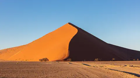
The Namib is a cool desert that runs for about 1,900 kilometers along Africa's Atlantic coast, from Angola through Namibia into South Africa. It gets almost no rain, but cold ocean water makes thick fog that drifts inland. UNESCO says its Namib Sand Sea is the only coastal desert in the world with huge dune fields influenced by fog.
Animals of South Africa
-
 Watch
3D
Animal
Lion
The lion is the only big cat that lives in a family group, called a pride. Lionesses hunt together, males guard the pride's land, and their roar can be heard about 8 kilometers away. Wild lions live in Africa, plus one small group in western India.
-
 Watch
Animal
Common hippopotamus
The common hippopotamus is one of the biggest animals on land, yet it spends most of the day resting in rivers and lakes to keep cool. At night it walks out to graze, and its special skin makes its own sunscreen.
-
 Watch
Animal
Nile crocodile
The Nile crocodile is Africa's largest crocodile. It lives in rivers, lakes and swamps across much of eastern, central and southern Africa and Madagascar. It eats mostly fish, basks on sunny banks and is a surprisingly caring parent.
-
 Watch
3D
Animal
Great white shark
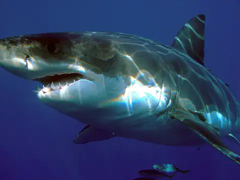
The great white shark is the largest of the mackerel sharks: a strong, torpedo-shaped fish with a gray back and a white belly. It hunts fish, seals and sea lions, and it is partly warm-blooded, which helps it stay active in cool water.
-
 Watch
Animal
Caracal
The caracal is a sleek, reddish-gold wild cat of Africa, the Middle East and Central Asia to India. Its name comes from a Turkish word meaning "black ears", for its black-backed ears with long tufts. It hunts on the ground, but it can leap two meters or more into the air to catch birds.
-
 Watch
3D
Animal
European bee-eater
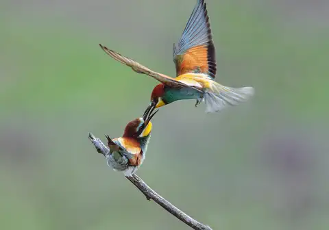
The European bee-eater is one of the most colorful birds in Europe. It catches bees, dragonflies and other flying insects in midair, knocks out the stings on a branch, and digs a long tunnel in a sandy bank for its nest. Every autumn it flies to Africa for the winter.
-
 Watch
Animal
Impala
The impala is a slender, reddish-brown antelope of the savannas of eastern and southern Africa. It can both graze on grass and browse on leaves, lives in herds, and when startled the whole herd bursts into spectacular leaps. Only males have the long, curving horns.
-
 Watch
3D
Animal
Common ostrich
The common ostrich is the tallest and heaviest bird alive. It cannot fly, but it is the fastest runner on two legs, sprinting at about 70 kilometers an hour across the savannas and deserts of Africa. It also lays the biggest egg of any living animal.
-
 Watch
Animal
Honey badger
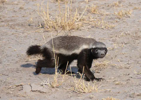
The honey badger, or ratel, is a stocky member of the weasel family that lives across Africa, the Middle East and India. Its gray or white back and black underside make it easy to spot. It digs with huge front claws, travels far to find food, and breaks into bees' nests for honey and bee grubs.
-
 Watch
Animal
African penguin
The African penguin is a penguin of warm, sunny coasts. It lives only in South Africa and Namibia, nests in burrows and under bushes, and hunts sardines and anchovies in the cold sea. Its numbers have fallen so far that it is now Critically Endangered, and people are working hard to protect it.
-
 Watch
Animal
Black mamba
The black mamba is a long, slender, very fast snake of the savannas and rocky hills of sub-Saharan Africa. It is gray to brown, gets its name from its inky-black mouth, hunts small mammals by day, and is shy: it would almost always rather slip away from people. It is also highly venomous, so it is a snake to admire from far away.
-
 Watch
3D
Animal
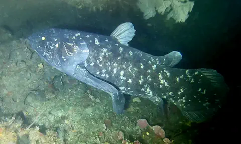
West Indian Ocean coelacanth
The West Indian Ocean coelacanth is a large, blue, spotted fish that lives in deep, rocky waters off eastern Africa. Its group was known only from fossils and thought to have died out about 66 million years ago, until a living one was found in South Africa in 1938.
Explore next
-
Watch
3D
Animal
Lion
The lion is the only big cat that lives in a family group, called a pride. Lionesses hunt together, males guard the pride's land, and their roar can be heard about 8 kilometers away. Wild lions live in Africa, plus one small group in western India.
-
Watch
Animal
Common hippopotamus
The common hippopotamus is one of the biggest animals on land, yet it spends most of the day resting in rivers and lakes to keep cool. At night it walks out to graze, and its special skin makes its own sunscreen.
-
Watch
Animal
Nile crocodile
The Nile crocodile is Africa's largest crocodile. It lives in rivers, lakes and swamps across much of eastern, central and southern Africa and Madagascar. It eats mostly fish, basks on sunny banks and is a surprisingly caring parent.
- Watch Geography Capital cities A capital is the city where a country's government is based. Many capitals grew up over hundreds of years beside rivers and trade routes. A few, like Brasília and Canberra, were built from scratch, and some countries share out their capital's jobs among two or three cities.
-
Watch
3D
Animal
Great white shark
The great white shark is the largest of the mackerel sharks: a strong, torpedo-shaped fish with a gray back and a white belly. It hunts fish, seals and sea lions, and it is partly warm-blooded, which helps it stay active in cool water.
-
Watch
Animal
Caracal
The caracal is a sleek, reddish-gold wild cat of Africa, the Middle East and Central Asia to India. Its name comes from a Turkish word meaning "black ears", for its black-backed ears with long tufts. It hunts on the ground, but it can leap two meters or more into the air to catch birds.
-
Watch
3D
Animal
European bee-eater
The European bee-eater is one of the most colorful birds in Europe. It catches bees, dragonflies and other flying insects in midair, knocks out the stings on a branch, and digs a long tunnel in a sandy bank for its nest. Every autumn it flies to Africa for the winter.
-
Watch
Animal
Impala
The impala is a slender, reddish-brown antelope of the savannas of eastern and southern Africa. It can both graze on grass and browse on leaves, lives in herds, and when startled the whole herd bursts into spectacular leaps. Only males have the long, curving horns.
For parents & teachers
What children will learn
- Locate South Africa, its two oceans, its neighbors and the enclave of Lesotho.
- Describe the high plateau, the Great Escarpment and the change in rainfall from east to west.
- Name some of South Africa's wildlife and protected places.
- Outline South Africa's history from early hominin fossils to the end of apartheid in 1994, calmly and factually.
Recommended ages: 3 to 17 · About 15 minutes
Talk about it
- Why might a country choose to have three capital cities instead of one?
- How could living with 12 official languages change what you see on signs, in schools and on television?
- Why do you think it mattered so much that every adult could vote in 1994?
Try at home or in class
- On a map of Africa, find South Africa and color Lesotho a different color to see how it sits inside.
- Learn to say hello in two of South Africa's official languages and practice with a friend or family member.
Key vocabulary: plateau, escarpment, enclave, fynbos, apartheid, fossil, braai
Where these facts come from
- Wikidata , Wikimedia Foundation (CC0 1.0)
- Natural Earth vector data , Natural Earth (NACIS) (Public domain)
- UNESCO World Heritage List , UNESCO World Heritage Centre (Linked as a reference; site facts come from Wikidata)
- South Africa's population bumps up by 421,000 people in 2026, Stats SA reports (Mid-year population estimates 2026) , Eyewitness News (EWN)
- SA is higher than we thought (Mafadi survey, Mountain Club of South Africa) , Mail & Guardian
- Mafadi peak sprouts a metre , News24
- South Africa (introduction) , Encyclopaedia Britannica
- South Africa: Relief and drainage , Encyclopaedia Britannica
- South Africa: Soils, climate, plant and animal life , Encyclopaedia Britannica
- South Africa: Conservation and ethnic groups , Encyclopaedia Britannica
- South Africa: Languages, religion and settlement , Encyclopaedia Britannica
- South Africa: Cultural life , Encyclopaedia Britannica
- South Africa: History , Encyclopaedia Britannica
- South Africa: The Late Stone Age , Encyclopaedia Britannica
- South Africa: The Iron Age , Encyclopaedia Britannica
- South Africa: Reconstruction, union, and segregation, 1902–29 , Encyclopaedia Britannica
- South Africa: The National Party and apartheid , Encyclopaedia Britannica
- South Africa: The unraveling of apartheid , Encyclopaedia Britannica
- South Africa: Postapartheid South Africa , Encyclopaedia Britannica
- Cape Town , Encyclopaedia Britannica
- Johannesburg , Encyclopaedia Britannica
- Table Mountain , Encyclopaedia Britannica
- Drakensberg , Encyclopaedia Britannica
- Tugela River , Encyclopaedia Britannica
- Kruger National Park , Encyclopaedia Britannica
- Fossil Hominid Sites of South Africa , UNESCO World Heritage Centre
- Robben Island , UNESCO World Heritage Centre
- Maloti-Drakensberg Park , UNESCO World Heritage Centre
- Cape Floral Region Protected Areas , UNESCO World Heritage Centre
- iSimangaliso Wetland Park , UNESCO World Heritage Centre
- Mapungubwe Cultural Landscape , UNESCO World Heritage Centre
- Richtersveld Cultural and Botanical Landscape , UNESCO World Heritage Centre
- Vredefort Dome , UNESCO World Heritage Centre
- Sterkfontein , Encyclopaedia Britannica
- PlayOwl region table, version 1 , PlayOwl (PlayOwl original data)
- flag-icons 7.5.0 , Panayiotis Lipiridis and contributors (MIT)
- Wikimedia Commons , Wikimedia Foundation (Per file (public domain, CC0, CC BY or CC BY-SA); see each media record)
Checked, not yet human-reviewed. Last updated October 24, 2026. Spotted a mistake? Tell us.
Picture credits
- Photo: Diego Delso, CC BY-SA 4.0, via Wikimedia Commons · source · license
- Photo: Evan Bench, CC BY 2.0, via Wikimedia Commons · source · license
- Photo: Juniper339, CC BY-SA 4.0, via Wikimedia Commons · source · license
- Photo: Olof Somell (Nobel Museum), CC BY-SA 4.0, via Wikimedia Commons · source · license
- Photo: =XEON=, CC BY 3.0, via Wikimedia Commons · source · license
- Photo: Martin Cígler, CC BY-SA 3.0, via Wikimedia Commons · source · license
- Photo: Winfried Bruenken (Amrum), CC BY-SA 2.5, via Wikimedia Commons · source · license