Natural wonder Africa
Namib
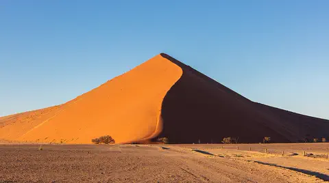
The Namib is a desert right next to the ocean in Africa. It has giant sand dunes. Fog from the sea brings water to its animals and plants.
The Namib is a cool desert that runs for about 1,900 kilometers along Africa's Atlantic coast, from Angola through Namibia into South Africa. It gets almost no rain, but cold ocean water makes thick fog that drifts inland. UNESCO says its Namib Sand Sea is the only coastal desert in the world with huge dune fields influenced by fog.
The Namib is a cool coastal desert extending about 1,900 km from Namibe in Angola to the Olifants River in South Africa and 130 to 160 km inland to the Great Escarpment (Britannica). The cold Benguela Current produces a 300 m marine inversion: fog below, hot dry air above, with only about 13 mm of rain a year at the coast. The Namib Sand Sea, a World Heritage Site since 2013, holds dunes up to about 240 m high built from sand carried thousands of kilometers by rivers, currents and wind.
Photo: Diego Delso, CC BY-SA 4.0, via Wikimedia Commons
Discover the Namib
The Namib is a desert right by the ocean.
It is in the south of Africa. It almost never rains there. Huge orange and red sand dunes stretch for miles. In the morning, fog rolls in from the sea.
The Namib stretches about 1,900 kilometers along the Atlantic coast of southern Africa, from Angola through Namibia to South Africa, and reaches 130 to 160 kilometers inland. Its name comes from the Nama language and suggests an area where there is nothing, Britannica says.
But the Namib is full of surprises. In its southern half lies a vast sea of sand, yellow-gray near the coast and brick red farther inland, with dunes up to about 240 meters high. UNESCO calls the Namib Sand Sea the only coastal desert in the world with huge dune fields influenced by fog, and made it a World Heritage Site in 2013.
Britannica describes the Namib as a cool coastal desert running about 1,900 km from Namibe (formerly Moçâmedes) in Angola across Namibia to the Olifants River in South Africa's Western Cape, and 130 to 160 km inland to the foot of the Great Escarpment; its southern part merges with the Kalahari on the plateau above. The name derives from Nama and implies 'an area where there is nothing'.
Three north-south strips grade into each other: a narrow, marine-dominated coastal strip; the Outer Namib, the rest of the western half; and the Inner Namib to the east. The desert rests on a smooth platform of truncated bedrock, mostly mica-schist, other metamorphics and granite, rising to about 900 m at the escarpment. UNESCO's 2013 inscription covers the Namib Sand Sea, 30,777 km² wholly within Namibia's Namib-Naukluft Park (49,768 km²), as the world's only coastal desert with extensive fog-influenced dune fields.
- Length along the coast
- about 1,900 km
- Width inland
- 130 to 160 km
- Countries
- Angola, Namibia and South Africa
- Yearly rain at the coast
- about 13 mm
- Namib Sand Sea (World Heritage, 2013)
- 30,777 km²
Fog, wind and a river of sand
A cold ocean current flows past the Namib.
It cools the air and makes fog, but not rain. Rivers carry sand to the sea. Ocean currents carry it along the coast, and the wind blows it onto land and piles it into giant dunes.
Why is the Namib so dry and foggy? A cold ocean current, the Benguela Current, flows north along the coast. It chills the air above it and makes fog. A sea breeze carries this cool, foggy air inland under a layer of hot, dry air, so the coast is almost always damp but almost never gets rain.
The sand has an amazing journey. UNESCO explains that it is carried thousands of kilometers from far inland by rivers, then moved along the coast by ocean currents, then blown inland by the wind, a kind of three-part conveyor belt. In the south, the wind has built long lines of dunes; single dunes can be 16 to 32 kilometers long.
Britannica explains the climate: the cold, northward-flowing Benguela Current chills the overlying air and produces fog, which a southwest sea breeze carries inland, creating a temperature inversion about 300 m thick with fog below and hot, dry air above. Coastal temperatures stay between about 10 and 16 °C; inland margins reach the low 30s °C in summer, and sheltered canyons exceed 38 °C. A few days a year, hot, dusty berg winds blow from the east to the coast.
UNESCO describes the Namib Sand Sea as two dune systems, an ancient semi-consolidated one overlain by a younger active one, built by a three-part 'conveyor': river erosion carries material from the interior, ocean currents move it along the coast and wind drives it inland; most dune fields elsewhere derive from bedrock eroded in place. Britannica notes dune lines trending north-northwest to south-southeast, individual dunes 16 to 32 km long and 60 to 240 m high, with smaller transverse dunes in the troughs and fast-moving barchans in the far south.
Living on fog
Many Namib animals and plants drink water from the fog.
Some tiny animals dive into the sand to stay safe. Gemsbok and springbok live on the plains. Seals and flamingos live by the sea.
UNESCO says fog is the main source of water in the Namib Sand Sea, and many animals found nowhere else, mostly invertebrates (small animals without backbones), collect it in extraordinary ways. Loose, airy sand gives some animals a place to swim and dive under the surface, to rest and to escape.
Britannica describes a strange Namib plant, the welwitschia, which grows just two giant leaves that sprawl across the ground. Gemsbok, springbok, ostriches and some zebras live on the inland plains and dunes, and elephants, rhinoceroses and lions live in the north along the rivers. The shore is busy with flamingos, pelicans, penguins in the south, and seal colonies.
UNESCO's criteria stress that fog is the primary water source and is harvested in extraordinary ways by a largely invertebrate endemic fauna, while well-oxygenated subsurface sand offers refuge to 'swimming' and 'diving' invertebrates, reptiles and mammals. Shifting sand, variable winds and fog gradients create an ever-changing mosaic of microhabitats.
Britannica recognizes six vegetation regions: succulent coastal vegetation using fog moisture; the almost barren Outer Namib; Inner Namib steppes, grassy only in wet years; a surprisingly rich bush and tall-grass flora on the Inner Namib dunes; large trees, especially acacias, along river channels; and succulent bush in the southern winter-rainfall area. The welwitschia (Welwitschia mirabilis) sprawls two gigantic leaves from a huge root crown. Gemsbok, springbok, ostriches and zebras use the Inner Namib; elephants, rhinoceroses, lions, hyenas and jackals follow northern rivers; Outer Namib dunes hold beetles, geckos and snakes but virtually no mammals; the shore supports flamingos, pelicans, penguins and seals.

Herders, ports and protected parks
Very few people live in the Namib.
Some families still herd goats and sheep along the rivers. A few towns sit by the sea. Much of the desert is a park where nature is protected.
Very few people live in the Namib. Britannica says a small number of Herero families still herd cattle and goats from water hole to water hole in the north, and Topnaar Nama families graze sheep and goats along the Kuiseb River. Long ago, San people gathered food along the shore and hunted inland.
Four cities sit on the coast, including Swakopmund and the port of Walvis Bay. Water for these towns is pumped from under the sandy bed of the Kuiseb River. Much of the central and northern Namib is now protected, in parks such as the Namib-Naukluft Park, which contains the Namib Sand Sea, and the Skeleton Coast National Park.
Britannica notes that a few San used the Namib until the early 20th century, foraging along the shore, hunting inland and drawing water from tsama melons; a small number of Herero still herd cattle and goats in the desert Kaokoveld, and a few Topnaar Nama graze stock along the Kuiseb. Water for Walvis Bay and Swakopmund is drawn from the Kuiseb's underflow 40 km inland, and a 130 km pipeline supplies Lüderitz from the Koichab.
The coast has four cities: Swakopmund, a resort affected by a large uranium mine 40 km inland; Walvis Bay, Namibia's major port, transferred from South Africa in 1994; Lüderitz; and Oranjemund, a diamond-mining town. The Sperrgebiet, from the Kuiseb to the Orange, was long closed for possible diamonds. UNESCO notes the Sand Sea has been under conservation management for more than 50 years, with no permanent visitor infrastructure inside the property.

Visiting safely
The Namib can be very hot inland and cool by the sea.
Bring water, a hat and a warm layer. Stay on the paths with a grown-up. Some areas are closed to protect nature.
The Namib can switch from cool and foggy at the coast, around 10 to 16 °C, to very hot in sheltered canyons, over 38 °C. A few days a year, hot, dusty winds blow from inland. So carry plenty of water, and pack sun protection and a warm layer.
Roads are few: away from a few stretches, there are no improved roads along much of the coast. Travel with a guide or a well-prepared group, and stay on marked routes. Some areas, such as parts of the Skeleton Coast National Park, have restricted entry to protect the fragile desert, so follow park rules.
Britannica's climate figures span 10 to 16 °C at the coast to more than 38 °C in canyons and lee slopes, occasional frost on the inner edge, and berg winds bringing heat above 38 °C and dust to the coast; rare rains come as short, torrential thunderstorms. Improved roads exist only on a few coastal stretches, and none in the Kaokoveld or between Walvis Bay and Lüderitz.
Access is managed for conservation: Skeleton Coast National Park restricts entry to protect its fragile environment, the Sperrgebiet was long closed, and UNESCO records that visitation within the Namib Sand Sea is limited to small, temporary point locations, with managers balancing growing visitor demand against untouched dunescapes. Visitors should plan water and fuel, use guides, keep to permitted routes and leave no trace.
Amazing facts
-
The Namib's sand traveled a very long way.
The sand in the Namib Sand Sea was carried thousands of kilometers from far inland by rivers, ocean currents and wind.
UNESCO describes a three-part conveyor of river erosion, ocean currents and wind that moved the Sand Sea's material thousands of kilometers.
-
The welwitschia plant has just two giant leaves.
The welwitschia, a strange Namib plant, grows only two gigantic leaves that sprawl across the ground from a huge root crown.
Welwitschia mirabilis spreads two gigantic leaves over the ground from the crest of its root crown (Britannica).
-
Some Namib animals swim through sand.
Loose, airy sand lets some Namib animals 'swim' and 'dive' under the surface to rest and to escape.
UNESCO notes well-oxygenated subsurface sand that offers refuge for 'swimming' and 'diving' invertebrates, reptiles and mammals.
-
The coast of the Namib is damp but almost never rainy.
The Namib coast gets only about 13 millimeters of rain a year, yet its air is almost always damp because of fog.
Britannica: the coast is almost rainless, about 13 mm a year, yet its air is almost always at or near saturation.
Words to know
- desert
- a place that gets very little rain or snow
- fog
- a cloud that sits low, right next to the ground or the sea
- sand dune
- a hill of sand piled up by the wind
- ocean current
- a steady flow of ocean water in one direction, like a river in the sea
- endemic
- found naturally in only one place in the world
- escarpment
- a long, steep slope or cliff at the edge of high land
Discovery challenge
-
What is next to the Namib Desert?
Which ocean does the Namib run beside?
Along which ocean margin does the Namib extend about 1,900 km?
- The Atlantic Ocean
- The Arctic Ocean
- The Indian Ocean
Show the answer
The Atlantic Ocean
The Atlantic Ocean, right next to the sand.
The Atlantic Ocean, along the coasts of Angola, Namibia and South Africa.
The South Atlantic, from Namibe in Angola to the Olifants River.
-
Where do many Namib animals get water?
What is the main source of water for life in the Namib Sand Sea?
What does UNESCO identify as the primary water source in the Namib Sand Sea?
- Fog from the sea
- Big rivers everywhere
- Heavy rain every day
Show the answer
Fog from the sea
Fog! It rolls in from the sea.
Fog, made by the cold ocean current; there is almost no rain.
Fog, harvested by specially adapted, mostly invertebrate endemic species.
-
What makes the fog in the Namib?
What makes fog along the Namib coast?
Which current chills the coastal air and produces the Namib's fog?
- A cold ocean current
- Hot volcanoes
- Melting glaciers
Show the answer
A cold ocean current
A cold current in the ocean cools the air.
The cold Benguela Current chills the air above it and makes fog.
The cold, northward-flowing Benguela Current.
-
How tall can Namib dunes be?
About how high can the Namib's tallest dunes be?
What height range does Britannica give for the southern Namib's dunes?
- Up to about 240 meters
- About 2 meters
- About 5,000 meters
Show the answer
Up to about 240 meters
Very tall: up to about 240 meters!
Up to about 240 meters, in lines 16 to 32 kilometers long.
60 to 240 m, with individual dunes 16 to 32 km long.
-
Which strange plant grows only two big leaves?
Which Namib plant grows just two giant leaves?
Which plant sprawls two gigantic leaves from a huge root crown?
- The welwitschia
- The palm tree
- The sunflower
Show the answer
The welwitschia
The welwitschia, with two long leaves.
The welwitschia, whose two leaves sprawl across the ground.
Welwitschia mirabilis.
Nearby places
-
 Watch
Natural wonder
Kalahari Desert
The Kalahari is a giant sandy plain in southern Africa, covering almost all of Botswana and parts of Namibia and South Africa. It stretches about 1,600 kilometers from north to south. Its southwest is a true desert, with long red dunes, while its north is green with woodlands and even has a huge swamp, the Okavango Delta.
-
 Watch
Natural wonder
Okavango Delta
The Okavango Delta, in northwestern Botswana, is a huge wetland in the middle of a dry land. The Okavango River flows in from Angola, spreads out into channels, lagoons and grassy plains, and then soaks away into the sands of the Kalahari instead of reaching the sea. Its flood arrives in the dry season, drawing elephants, buffalo, zebras and many other animals.
-
 Watch
Natural wonder
Victoria Falls
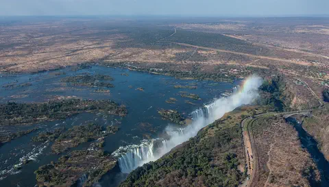
Victoria Falls, on the Zambezi River between Zambia and Zimbabwe, is about 1,708 meters wide and up to 108 meters deep. UNESCO calls it the largest curtain of falling water in the world, and its spray can be seen from tens of kilometers away.
-
 Watch
Natural wonder
River Congo
The Congo is Africa's second-longest river, about 4,700 kilometers long. It curves in a giant arc through the rainforests of central Africa and empties into the Atlantic Ocean. Rain falls in its basin all year, so it carries a huge amount of water, and its wild lower rapids are home to about 320 kinds of fish, about 90 of them found nowhere else.
-
 Watch
Natural wonder
Lake Tanganyika
Lake Tanganyika lies in a deep crack in Africa called a rift valley. Britannica calls it the longest freshwater lake in the world, and only Lake Baikal, in Russia, is deeper. Four countries share it: Tanzania, the Democratic Republic of the Congo, Burundi and Zambia. Its water is home to about 250 kinds of cichlid fish found nowhere else.
-
 Watch
Natural wonder
Mount Nyiragongo
Mount Nyiragongo is a steep volcano in the Virunga Mountains of the Democratic Republic of the Congo, near the border with Rwanda and just north of Lake Kivu. It is 3,470 meters high, and its deep summit crater often holds a lake of bubbling lava. Its lava is very runny, and eruptions in 1977, 2002 and 2021 sent lava flowing down its sides toward the city of Goma.
-
 Watch
Natural wonder
Virunga National Park
Virunga National Park, in the east of the Democratic Republic of the Congo, was founded in 1925; the park describes itself as Africa's first national park. It stretches from active volcanoes in the south to the snowy Rwenzori Mountains in the north. About one third of the world's mountain gorillas live in its forests, along with elephants, hippos, chimpanzees and hundreds of kinds of birds.
-
 Watch
Natural wonder
Ngorongoro Conservation Area
The Ngorongoro Conservation Area in northern Tanzania holds the Ngorongoro Crater, a giant bowl about 16 to 20 kilometers across, left when an ancient volcano collapsed about 2.5 million years ago. Around 25,000 large animals live in and around the crater. The area also protects Olduvai Gorge and Laetoli, where scientists have found important evidence of how humans evolved.
Explore next
-
Watch
 Country
Namibia
Namibia lies on the southwestern coast of Africa. The Namib, a desert of huge dunes kept alive by sea fog, runs along its coast, a high plateau with farms and wildlife fills its middle, and the dry Kalahari lies to the east. Namibia became independent in 1990.
-
 Watch
 Country
Angola
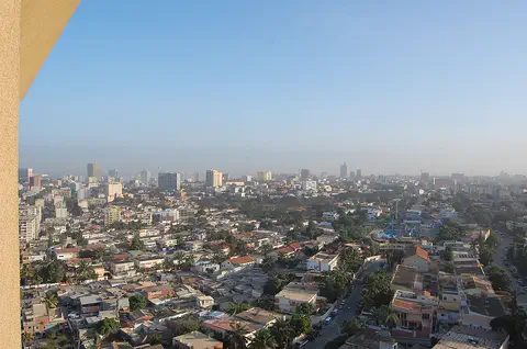
Angola is a large country in southwestern Africa, on the Atlantic Ocean. A narrow coast rises steeply to high plateaus, rivers such as the Cuanza run to the sea, and the Namib Desert reaches its far southwest. Its national statistics institute projects about 38.8 million people for 2026.
-
 Watch
 Country
South Africa
South Africa is the southernmost country in Africa, with the Atlantic Ocean on one side and the Indian Ocean on the other. A high plateau covers most of it, about 63.5 million people (2026) live there, and it has 12 official languages and three capital cities.
-
Watch
Natural wonder
Kalahari Desert
The Kalahari is a giant sandy plain in southern Africa, covering almost all of Botswana and parts of Namibia and South Africa. It stretches about 1,600 kilometers from north to south. Its southwest is a true desert, with long red dunes, while its north is green with woodlands and even has a huge swamp, the Okavango Delta.
-
 Watch
Natural wonder
Atacama Desert
The Atacama is a cool desert in northern Chile, squeezed between the Pacific coast and the Andes mountains, about 1,000 to 1,100 kilometers long. It is one of the driest places on Earth: the city of Arica, on its coast, averages less than 1 millimeter of rain a year. Its dry, clear air makes it a top place for giant telescopes.
- Watch Geography What makes a desert? A desert is any place that gets very little rain or snow, usually less than about 250 millimeters a year. Deserts can be hot, like the Sahara, or freezing cold, like Antarctica, the driest continent. They form where winds, mountains or cold ocean currents keep rain away.
- Watch Geography Ocean currents Ocean currents are flows of seawater from one place to another. Winds push the surface water, and because Earth spins, the currents curve into giant loops called gyres. Deep down, cold, salty water sinks and creeps slowly around the planet. Together, currents carry heat from the warm tropics toward the cold poles.
-
 Watch
Animal
African penguin
The African penguin is a penguin of warm, sunny coasts. It lives only in South Africa and Namibia, nests in burrows and under bushes, and hunts sardines and anchovies in the cold sea. Its numbers have fallen so far that it is now Critically Endangered, and people are working hard to protect it.
For parents & teachers
What children will learn
- Locate the Namib along the Atlantic coast of Angola, Namibia and South Africa.
- Explain how the cold Benguela Current makes a foggy but rainless coast.
- Describe how the Namib Sand Sea's sand traveled by river, ocean current and wind.
- Describe how plants and animals use fog to survive.
Recommended ages: 3 to 17 · About 15 minutes
Talk about it
- How can a place be damp and foggy but still be a desert?
- Why might the sand in a desert have come from somewhere far away?
- Why do some parks limit where visitors can go?
Try at home or in class
- Put a cold can from the fridge on a plate on a warm day and watch drops form and run down; talk about how Namib beetles and plants catch water from fog.
- Make a 'sand conveyor': wash sand down a tilted tray with water (the river), push it along the bottom with a ruler (the current), then fan it into a pile (the wind).
Key vocabulary: desert, fog, sand dune, ocean current, endemic, escarpment
Where these facts come from
- Wikidata , Wikimedia Foundation (CC0 1.0)
- Natural Earth vector data , Natural Earth (NACIS) (Public domain)
- Namib , Encyclopaedia Britannica
- Namib: People and economy , Encyclopaedia Britannica
- Namib Sand Sea , UNESCO World Heritage Centre
- UNESCO World Heritage List , UNESCO World Heritage Centre (Linked as a reference; site facts come from Wikidata)
- Wikimedia Commons , Wikimedia Foundation (Per file (public domain, CC0, CC BY or CC BY-SA); see each media record)
Checked, not yet human-reviewed. Last updated October 27, 2026. Spotted a mistake? Tell us.