
Natural wonder Africa
Kalahari Desert
The Kalahari is a huge, dry land of red sand in southern Africa. Grass and thorny trees grow there. Giraffes, zebras and lions live there too.
The Kalahari is a giant sandy plain in southern Africa, covering almost all of Botswana and parts of Namibia and South Africa. It stretches about 1,600 kilometers from north to south. Its southwest is a true desert, with long red dunes, while its north is green with woodlands and even has a huge swamp, the Okavango Delta.
The Kalahari is a basin-like, sand-covered plain on the interior plateau of southern Africa, about 1,600 km north to south and estimated at some 930,000 km² (Britannica). It lies everywhere at 900 m or more above sea level. Only its southwestern half meets climatic definitions of a desert; the wetter northeast suffers edaphic drought, because rain drains straight through deep Pleistocene sands. Its surfaces are wind-formed sand sheets, longitudinal dunes and pans.
Photo: Giles Laurent, CC BY-SA 4.0, via Wikimedia Commons
Discover the Kalahari
The Kalahari is a very big, dry land in Africa.
It is covered in sand, and lots of the sand is red. Grass and thorny trees grow on it. Days can be very hot, and winter nights can be freezing.
The Kalahari is a huge, gently rolling plain of sand in southern Africa. Britannica says it covers almost all of Botswana, the eastern third of Namibia and the northern tip of South Africa's Northern Cape province. It is about 1,600 kilometers from north to south and is estimated at some 930,000 square kilometers.
The Kalahari is high up: all of it lies at least 900 meters above sea level. Much of the sand is red, because each grain has a thin coat of iron oxide, a kind of rust. To the southwest, the Kalahari meets the Namib, the desert along Namibia's coast.
Britannica describes the Kalahari as a large basin-like plain of the interior plateau of southern Africa, occupying almost all of Botswana, the eastern third of Namibia and the northernmost Northern Cape in South Africa; its greatest north-south extent is roughly 1,600 km, its greatest east-west extent about 600 miles (970 km), and its area some 930,000 km². In the southwest it merges with the Namib. Natural Earth's outline of the region also reaches into southern Angola.
It is a featureless, gently undulating sand plain, everywhere at 900 m or more above sea level. Bedrock appears only in kopjes, low but vertical-walled hills. Whether the Kalahari counts as a desert depends on where you stand: Britannica explains that the southwestern half receives under 250 mm of rain a year, and its potential evaporation is twice its precipitation, but the northeast receives more than 500 mm and climatically is not a desert at all, though it lacks surface water.
- North to south
- about 1,600 km
- Area (estimate)
- about 930,000 km²
- Height above sea level
- 900 m or more everywhere
- Countries
- Botswana, Namibia and South Africa
- Summer day, in the shade
- often 43 to 46 °C
Sand sheets, dunes and pans
Long ago, wind blew lots of sand across the land.
In some places the wind made long hills of sand called dunes. In other places there are flat white pans, old dry lakes. When it rains, the water sinks into the sand.
Three kinds of land make up almost all of the Kalahari, Britannica explains. In the east are sand sheets, flat blankets of sand more than 60 meters deep, mostly spread by wind during the Ice Ages. In the west, long chains of dunes run toward the north or northwest. Each dune is at least 1.6 kilometers long and 6 to 60 meters high, with a wide, flat lane between dunes that people call a straat, or street.
The third kind are pans: flat, bare, white dry lakes where streams once ended. When rain falls on the Kalahari, it mostly disappears straight into the deep sand. Some soaks into the rock below, and some is pulled back up by the long roots of trees.
Britannica identifies three surfaces besides the kopjes. Sand sheets in the east appear to have formed in the Pleistocene (about 2.6 million to 11,700 years ago) and have been fixed since; a few are fluvial, from sheet flooding in wetter times, but most are wind-formed, with relief of only tens of feet per mile and sand generally more than 200 ft (about 60 m) deep, reddened by iron-oxide coatings. The whole western Kalahari carries long north- or northwest-trending dune chains at least 1 mile long and 20 to 200 ft (6 to 60 m) high, separated by broad parallel straats.
Vleis, or pans, are terminal features of former drainage: streams that never reached the sea ended in closed depressions, where silt, calcium minerals and salts settled out as the water evaporated, leaving hard, white, vegetation-free surfaces. In the south and centre, surface drainage is nonexistent; rain sinks into the sand, recharges rock strata, evaporates by capillary rise, or is transpired by deep-rooted trees. Ancient drainage networks detected on the ground and from the air no longer flow, even in the wettest years.
A swamp in the sand
In the north of the Kalahari there is lots of water!
A river flows in from far away. It spreads out into a giant swamp called the Okavango Delta. Elephants, zebras and many birds come to drink.
Here is a surprise: in the dry Kalahari there is a huge wetland. Every summer, heavy rains fall far to the northwest, in the hills of Angola. The water runs into the Okavango River, which flows southeast into the northern Kalahari and spreads out into many channels, swamps and floodplains in Botswana: the Okavango Delta.
UNESCO explains that the delta's water never reaches the sea. It drains into the Kalahari's sands instead. The flood arrives during the dry season, so plants and animals time their lives to it, and large herds of elephants, buffalo and zebras gather there. After very wet years, the extra water can even flow on to Lake Ngami and the Makgadikgadi Pans.
Britannica calls the northern Kalahari's drainage extraordinary: summer rains on the uplands of central Angola feed the south-flowing streams that form the Okavango and Cuando rivers. The Okavango breaks into distributary channels in northern Botswana and feeds a vast swamp; after abnormally wet seasons, overflow fills Lake Ngami and runs east along the Boteti River to Lake Xau and the Makgadikgadi Pans, creating, in Britannica's words, an area with an excess of water in a region chronically short of it.
UNESCO's World Heritage listing (2014) describes the Okavango Delta as a low-gradient alluvial fan of about 600,000 ha of permanent swamp and up to 1.2 million ha of seasonally flooded grassland, one of very few large endorheic deltas, draining into the sands of the Kalahari Basin. Because the flood peaks in the dry winter (June and July), its biota synchronize breeding and growth with the floodwater. The delta lies within the African rift system, whose geology captured the Okavango River.

Antelopes, giraffes and thorn trees
Many animals live in the Kalahari.
Gemsbok and springbok are antelopes that can live where there is little water. Giraffes and zebras live in the north. Lions, cheetahs and ostriches live there too.
The Kalahari is greener in the north and drier in the south, and so are its animals. Britannica says the dry southwest has only scattered tough shrubs and short grass, the center has scattered acacia trees, and the north has open woodlands, palm trees, thorn bushes and big baobab trees.
Even in the dry south, many animals stay for much of the year without any pools to drink from: springbok, wildebeest and hartebeest, sometimes in great herds, and gemsbok, a kind of oryx, eland, kudu and the little steenbok. The north is home to giraffes, zebras, elephants, buffalo, lions, cheetahs, leopards, African wild dogs, hyenas, warthogs and lots of birds.
Deep sand shapes the vegetation, Britannica explains: shallow-rooted perennials cannot survive, but fast-growing annuals set seed after good rains, and trees whose roots reach permanently moist sand do well. The southwest has scattered xerophytic shrubs and short grasses; the centre, scattered acacias; the north, open woodland, palms among thorn brush and forests up to about 15 m tall, including the baobab. Kgalagadi Transfrontier Park, which Britannica describes as largely reddish dunes with acacias in the riverbeds, has quick grass, gemsbok cucumber, driedoring and raisinbush as forage.
In the south, springbok, wildebeest and hartebeest (occasionally in great herds), gemsbok, eland, kudu, steenbok and duiker persist for long periods without surface water. The north supports giraffe, zebra, elephant, buffalo, roan, sable, tsessebe and impala, with lions, cheetahs, leopards, wild dogs, jackals, hyenas, warthogs, baboons and ant bears. UNESCO adds that Botswana holds the world's largest elephant population, about 130,000, with the Okavango Delta at its core.

People of the Kalahari
Many families live in villages in the Kalahari.
They keep cattle and goats and grow corn and pumpkins. Some San families once lived by gathering wild plants and hunting. At Tsodilo Hills, people painted animals on the rocks long ago.
People live across the Kalahari in many different ways. Britannica explains that in remote areas many families live in villages of 200 to 5,000 people, often in huts with mud walls and thatched roofs. Villages are built near wells or boreholes, because water is scarce. Cattle are very important, and goats give milk and meat. Most households grow corn, sorghum and pumpkins.
The San, called Basarwa in much of the region, are one of the Kalahari's peoples; Britannica calls the Bantu-speaking groups relative newcomers who arrived from the late 1700s. Some San groups lived as hunter-gatherers until the 1970s, gathering wild plants and hunting antelope, and moving camp every few weeks. Today few still live that way. At the Tsodilo Hills, UNESCO counts more than 4,500 rock paintings, and people have used the hills for over 100,000 years. In 1971 a big diamond mine opened at Orapa, in Botswana, and mining and tourism now bring jobs.
Britannica describes a population chiefly of Bantu speakers (the Tswana, Kgalagadi and Herero, who arrived from the late 18th century onward, the Herero as refugees from the German-Herero conflict of 1904 to 1907) and Khoisan-speaking San, with a small number of Europeans. Settlement is limited to wells and boreholes; cattle are the basis of the economy, and Britannica warns that poorly managed grazing causes pasture loss and desertification. Diamond mining began at Orapa in 1971.
Among San groups that lived as autonomous foragers until the 1970s, the G/wi of the Central Kalahari were intensively studied: bands of 5 to 16 households held territories of 300 to 400 square miles, relied mainly on eight staple food plants, moved camp every three or four weeks and split into households during the lean winter. Few San now live by foraging, and Britannica notes that many were resettled, often against their will, by Botswana's government from the Central Kalahari Game Reserve to villages outside it. At the Tsodilo Hills in northwest Botswana, a World Heritage Site since 2001, UNESCO records more than 4,500 rock paintings in only 10 km² and human use of the hills for over 100,000 years.

Visiting safely
The Kalahari can be very hot in the day and cold at night.
Bring lots of water, a hat and warm clothes. Stay in the car near wild animals. Travel with a grown-up and a guide.
The Kalahari is a land of big temperature swings. Britannica says summer days can reach 43 to 46 °C in the shade, then cool to about 21 to 27 °C at night, and winter nights often freeze. There is no surface water in most of the south and center, and many tracks are only passable by trucks or four-wheel-drive cars.
So plan carefully: travel with an experienced guide or in a well-equipped group, carry far more water than you think you need, and pack for both heat and cold. Parks such as Kgalagadi have lions and other big animals, so follow park rules and watch wildlife from your vehicle.
Britannica attributes the Kalahari's large daily and seasonal temperature ranges to its altitude and clear, dry air: shade temperatures often reach 43 to 46 °C on summer days but fall to 21 to 27 °C the same night, and winter nights commonly drop to freezing and occasionally to about −12 °C. Winters bring six to eight rainless months, surface water is almost absent in the south and centre, and most roads and tracks require trucks or four-wheel-drive vehicles.
The Kgalagadi Transfrontier Park, 37,991 km² (Britannica; SANParks gives 37,256 km²), about three-quarters of it in Botswana, protects migratory herds across the border and is home to lions, wild dogs and other predators; SANParks notes that its name comes from the San language and means 'place of thirst'. Travelers should go with experienced guides, carry ample water, follow park rules and tread lightly on a fragile, grazing-stressed land.
Amazing facts
-
The Kalahari's sand is red because of rust.
Much of the Kalahari's sand is red because each grain is coated with a thin layer of iron oxide, the same stuff as rust.
Britannica attributes the red color of much Kalahari sand to a thin iron-oxide coating on the grains.
-
Part of the Kalahari gets too much rain to be a desert.
The northeast of the Kalahari gets more than 500 millimeters of rain a year, so it is not really a desert, but the rain sinks straight through the sand.
The northeastern Kalahari does not qualify climatically as a desert, yet it suffers edaphic drought: rain drains instantly through deep sand.
-
Kgalagadi means place of thirst.
The name of the Kgalagadi Transfrontier Park comes from the San language and means place of thirst.
SANParks derives Kgalagadi from the San language, meaning 'place of thirst'.
-
The Okavango River ends in the sand, not the sea.
The Okavango Delta is one of very few big river deltas that never reach the sea. Its water drains into the sands of the Kalahari.
UNESCO describes the Okavango as one of very few large endorheic deltas, Africa's largest, draining into the sands of the Kalahari Basin.
Words to know
- desert
- a place that gets very little rain or snow
- sand dune
- a hill of sand piled up by the wind
- pan
- a flat, dry lake bed, often white with salt or minerals
- delta
- an area where a river splits into many smaller channels as it spreads out
- borehole
- a deep, narrow hole drilled into the ground to reach water
- iron oxide
- a reddish coating, like rust, that forms on iron-rich materials
Discovery challenge
-
Which country is almost all covered by the Kalahari?
The Kalahari covers almost all of which country?
Which country does the Kalahari occupy almost entirely, according to Britannica?
- Botswana
- Egypt
- Kenya
Show the answer
Botswana
Botswana! The Kalahari covers almost all of it.
Botswana; it also covers the eastern third of Namibia and part of South Africa.
Botswana, with the eastern third of Namibia and the northernmost Northern Cape.
-
Why is a lot of Kalahari sand red?
What makes much of the Kalahari's sand red?
What gives much Kalahari sand its red color?
- A thin coat of iron oxide, like rust
- Red paint from people
- Red flowers growing everywhere
Show the answer
A thin coat of iron oxide, like rust
A thin coat of rust on each grain.
A thin coat of iron oxide on each grain of sand.
A thin iron-oxide coating on the grains.
-
Where does the Okavango River's water end up?
Where does the water of the Okavango Delta end up?
What makes the Okavango Delta unusual among large deltas?
- In the sands of the Kalahari
- In the ocean
- In a big waterfall
Show the answer
In the sands of the Kalahari
In the sand! It never reaches the sea.
It drains into the sands of the Kalahari and never reaches the sea.
It is endorheic: it has no outlet to the sea and drains into the Kalahari Basin.
-
Which antelope lives in the dry Kalahari?
Which antelope, a kind of oryx, lives in the dry southern Kalahari?
Which oryx subspecies is a principal grazer of the southern Kalahari and Kgalagadi?
- The gemsbok
- The polar bear
- The penguin
Show the answer
The gemsbok
The gemsbok, an antelope with long, straight horns.
The gemsbok, which can stay for long periods without drinking from pools.
The gemsbok, which Britannica lists with springbok, wildebeest and hartebeest.
-
What is a Kalahari pan?
What is a pan in the Kalahari?
How did the Kalahari's vleis, or pans, form?
- A flat, dry lake bed
- A cooking pot
- A tall mountain
Show the answer
A flat, dry lake bed
A flat, dry lake. It is often white.
A flat, bare, white dry lake bed where streams once ended.
Streams ended in closed depressions, where silt, calcium minerals and salts settled as water evaporated.
Nearby places
-
Watch
Natural wonder
Okavango Delta
The Okavango Delta, in northwestern Botswana, is a huge wetland in the middle of a dry land. The Okavango River flows in from Angola, spreads out into channels, lagoons and grassy plains, and then soaks away into the sands of the Kalahari instead of reaching the sea. Its flood arrives in the dry season, drawing elephants, buffalo, zebras and many other animals.
-
 Watch
Natural wonder
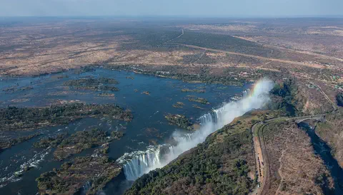
Victoria Falls
Victoria Falls, on the Zambezi River between Zambia and Zimbabwe, is about 1,708 meters wide and up to 108 meters deep. UNESCO calls it the largest curtain of falling water in the world, and its spray can be seen from tens of kilometers away.
-
 Watch
Natural wonder
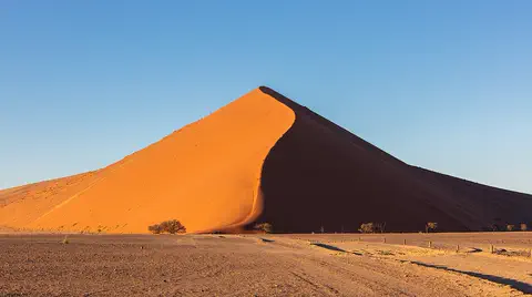
Namib
The Namib is a cool desert that runs for about 1,900 kilometers along Africa's Atlantic coast, from Angola through Namibia into South Africa. It gets almost no rain, but cold ocean water makes thick fog that drifts inland. UNESCO says its Namib Sand Sea is the only coastal desert in the world with huge dune fields influenced by fog.
-
 Watch
Natural wonder
Lake Tanganyika
Lake Tanganyika lies in a deep crack in Africa called a rift valley. Britannica calls it the longest freshwater lake in the world, and only Lake Baikal, in Russia, is deeper. Four countries share it: Tanzania, the Democratic Republic of the Congo, Burundi and Zambia. Its water is home to about 250 kinds of cichlid fish found nowhere else.
-
 Watch
Natural wonder
River Congo
The Congo is Africa's second-longest river, about 4,700 kilometers long. It curves in a giant arc through the rainforests of central Africa and empties into the Atlantic Ocean. Rain falls in its basin all year, so it carries a huge amount of water, and its wild lower rapids are home to about 320 kinds of fish, about 90 of them found nowhere else.
-
 Watch
Natural wonder
Mount Nyiragongo
Mount Nyiragongo is a steep volcano in the Virunga Mountains of the Democratic Republic of the Congo, near the border with Rwanda and just north of Lake Kivu. It is 3,470 meters high, and its deep summit crater often holds a lake of bubbling lava. Its lava is very runny, and eruptions in 1977, 2002 and 2021 sent lava flowing down its sides toward the city of Goma.
-
 Watch
Natural wonder
Virunga National Park
Virunga National Park, in the east of the Democratic Republic of the Congo, was founded in 1925; the park describes itself as Africa's first national park. It stretches from active volcanoes in the south to the snowy Rwenzori Mountains in the north. About one third of the world's mountain gorillas live in its forests, along with elephants, hippos, chimpanzees and hundreds of kinds of birds.
-
 Watch
Natural wonder
Ngorongoro Conservation Area
The Ngorongoro Conservation Area in northern Tanzania holds the Ngorongoro Crater, a giant bowl about 16 to 20 kilometers across, left when an ancient volcano collapsed about 2.5 million years ago. Around 25,000 large animals live in and around the crater. The area also protects Olduvai Gorge and Laetoli, where scientists have found important evidence of how humans evolved.
Experiments to try
Explore next
-
Watch
 Country
Botswana
Botswana is a landlocked country in the middle of southern Africa. Deep Kalahari sand covers most of it, but in the north the Okavango River spreads into a huge green delta full of wildlife. Botswana became independent in 1966 and has grown more prosperous, helped by diamonds.
-
Watch
 Country
Namibia
Namibia lies on the southwestern coast of Africa. The Namib, a desert of huge dunes kept alive by sea fog, runs along its coast, a high plateau with farms and wildlife fills its middle, and the dry Kalahari lies to the east. Namibia became independent in 1990.
-
 Watch
 Country
South Africa
South Africa is the southernmost country in Africa, with the Atlantic Ocean on one side and the Indian Ocean on the other. A high plateau covers most of it, about 63.5 million people (2026) live there, and it has 12 official languages and three capital cities.
-
Watch
Natural wonder
Okavango Delta
The Okavango Delta, in northwestern Botswana, is a huge wetland in the middle of a dry land. The Okavango River flows in from Angola, spreads out into channels, lagoons and grassy plains, and then soaks away into the sands of the Kalahari instead of reaching the sea. Its flood arrives in the dry season, drawing elephants, buffalo, zebras and many other animals.
-
Watch
Natural wonder
Namib
The Namib is a cool desert that runs for about 1,900 kilometers along Africa's Atlantic coast, from Angola through Namibia into South Africa. It gets almost no rain, but cold ocean water makes thick fog that drifts inland. UNESCO says its Namib Sand Sea is the only coastal desert in the world with huge dune fields influenced by fog.
-
 Watch
Natural wonder
Sahara
The Sahara fills almost all of northern Africa. Britannica calls it the largest hot desert in the world: about 4,800 kilometers from east to west and about 8.6 million square kilometers in all. Only about a quarter of it is sand dunes; the rest is gravel plains, rocky plateaus and mountains.
- Watch Geography What makes a desert? A desert is any place that gets very little rain or snow, usually less than about 250 millimeters a year. Deserts can be hot, like the Sahara, or freezing cold, like Antarctica, the driest continent. They form where winds, mountains or cold ocean currents keep rain away.
-
 Watch
Animal
Meerkat
Meerkats are small members of the mongoose family that live in dry, open country in southern Africa. They live in groups called mobs, dig for insects all day, and take turns as lookouts, standing tall and calling out if an eagle or jackal comes near. Everyone helps raise the babies.
For parents & teachers
What children will learn
- Locate the Kalahari across Botswana, Namibia and South Africa.
- Explain why only part of the Kalahari counts as a desert, using rainfall and evaporation.
- Describe sand sheets, dunes and pans, and how the Okavango Delta ends in the sand.
- Describe the ways people live in the Kalahari and the challenge of overgrazing.
Recommended ages: 3 to 17 · About 15 minutes
Talk about it
- Can a place get quite a lot of rain and still be dry? How?
- Why do you think animals gather at the Okavango Delta in the dry season?
- What could herders do to stop their land from turning into desert?
Try at home or in class
- Pour the same cup of water onto a tray of sand and a tray of soil. Time how fast it disappears, and look underneath to see where it went.
- Rub a steel wool pad with salt water and leave it overnight; see the red rust that forms, like the coating on Kalahari sand.
Key vocabulary: desert, sand dune, pan, delta, borehole, iron oxide
Where these facts come from
- Wikidata , Wikimedia Foundation (CC0 1.0)
- Natural Earth vector data , Natural Earth (NACIS) (Public domain)
- Kalahari Desert , Encyclopaedia Britannica
- Kalahari Desert: Climate (plant and animal life) , Encyclopaedia Britannica
- Kalahari Desert: People and economy , Encyclopaedia Britannica
- Okavango Delta , UNESCO World Heritage Centre
- Kgalagadi Transfrontier Park , Encyclopaedia Britannica
- Kgalagadi Transfrontier Park: Location , South African National Parks (SANParks)
- Tsodilo , UNESCO World Heritage Centre
- Wikimedia Commons , Wikimedia Foundation (Per file (public domain, CC0, CC BY or CC BY-SA); see each media record)
Checked, not yet human-reviewed. Last updated October 27, 2026. Spotted a mistake? Tell us.