 Country
Africa
Namibia
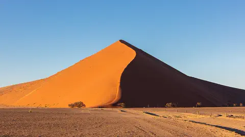
Namibia is a country in southern Africa by the Atlantic Ocean. It has giant red sand dunes, foggy beaches and lots of wild animals.
Namibia lies on the southwestern coast of Africa. The Namib, a desert of huge dunes kept alive by sea fog, runs along its coast, a high plateau with farms and wildlife fills its middle, and the dry Kalahari lies to the east. Namibia became independent in 1990.
Namibia, on Africa's southwestern Atlantic coast, divides into the coastal Namib desert, the Central Plateau and the Kalahari. Its only permanent rivers lie on its borders, fog is the main water source of the Namib Sand Sea, and after 106 years of German and South African rule it became independent on March 21, 1990; about 3.1 million people (2025) live there.
Photo: Diego Delso, CC BY-SA 4.0, via Wikimedia Commons
Discover Namibia
Namibia is a country in Africa.
It is next to the Atlantic Ocean. It has big sand dunes and dry, rocky land. The capital city is called Windhoek.
Namibia is on the southwestern coast of Africa, beside the Atlantic Ocean. It is roughly a rectangle, with a long, narrow strip of land in the northeast called the Caprivi Strip.
Namibia has three main kinds of land. Along the coast is the Namib desert, with huge sand dunes. In the middle is a high plateau of grass, bushes and hills, where most farming happens. In the east, the land slopes down into the Kalahari. About 3.1 million people lived in Namibia in 2025, and the capital is Windhoek.
Namibia lies on the southwestern coast of Africa, bordered by Angola, Zambia, Botswana, South Africa and the Atlantic. It is roughly rectangular, about 965 km by 480 to 725 km, with the long Caprivi Strip to the east, which Britannica traces to a German misconception that reaching the Zambezi meant reaching the Indian Ocean. It covers about 825,600 km².
Britannica describes a spectacular landscape of desert, mountains, canyons and savanna. The only permanent rivers are on the borders: the Kunene, Okavango, Kwando (Mashi) and Zambezi in the north and the Orange in the south. The World Bank put the population at 3,092,816 in 2025; about 43 percent lived in urban areas in 2023.
Cities and famous places
Windhoek is the capital city. It is on a high plateau.
Swakopmund is a town by the sea. At Twyfelfontein, people carved animals on rocks long ago.
Windhoek, the capital, sits on the Central Plateau in the middle of the country. Swakopmund and Walvis Bay are towns on the coast, where the Swakop and Kuiseb rivers reach the sea in rare flood years.
At Twyfelfontein in the northwest, rocks are covered with engravings of rhinos, elephants, ostriches and giraffes, plus human and animal footprints, made by San hunter-gatherers over at least 2,000 years. It is a World Heritage Site, and so is the Namib Sand Sea, whose dunes UNESCO calls outstanding for their age, size and height. Etosha National Park, around the Etosha Pan, is a major place to see wildlife.
Windhoek is the capital, on the Central Plateau; Greater Windhoek holds more than a tenth of the population. Swakopmund and Walvis Bay sit at the mouths of the Swakop and Kuiseb, which reach the sea only in rare flood years. Diamonds and uranium are mined at Oranjemund and Arandis in the Namib.
UNESCO lists two sites. Twyfelfontein or /Ui-//aes (2007) has one of the largest concentrations of rock engravings in Africa, mostly of rhinoceros, elephant, ostrich and giraffe, with human and animal footprints and six rock shelters painted with red-ochre figures; Late Stone Age finds and the engravings record hunter-gatherer practices over at least 2,000 years. The Namib Sand Sea (2013), over three million hectares, is described as the only coastal desert with extensive dune fields influenced by fog. Parks include Etosha, Skeleton Coast, Namib-Naukluft and Sperrgebiet.

Dunes, fog and canyons
The Namib desert has giant sand dunes.
It almost never rains there. Fog rolls in from the cold sea. Plants and animals drink the tiny drops of fog.
The Namib desert runs along the whole coast, 80 to 130 kilometers wide. A cold ocean current, the Benguela Current, cools the coast, and less than 50 millimeters of rain falls in a year. Instead, fog from the sea is the main source of water for the plants and animals of the dunes.
Inland, the Central Plateau rises 975 to 1,980 meters, cut by the giant Fish River Canyon and dotted with salt pans like the Etosha Pan. Namibia's highest mountain, the Brandberg, is 2,573 meters tall. Rain is more plentiful in the north, but droughts lasting several years are common.
Namibia divides west to east into the Namib, the Central Plateau and the Kalahari. The Namib, 80 to 130 km wide, is partly rocky and partly dunes; the cold Benguela Current, which also carries rich fish stocks, keeps the coast under 50 mm of rain a year. UNESCO's Namib Sand Sea holds two dune systems, an ancient semi-consolidated one beneath a younger active one, built from sand carried thousands of kilometers by rivers, ocean currents and wind; fog is the main water source, and endemic invertebrates, reptiles and mammals 'swim' and 'dive' in its loose sand.
The Central Plateau (975 to 1,980 m) is broken by hills, the Fish River Canyon and salt pans such as Etosha, with the Brandberg (2,573 m) on its western escarpment. Rainfall rises from about 250 mm in the south and west to more than 600 mm on the Caprivi Strip, and multiyear droughts are common. In Windhoek, December averages 24 °C and July 13 °C.
Animals of Namibia
Namibia has elephants, rhinos and zebras.
Springboks and gemsboks live in the dry land. In the desert, some tiny animals dive into the sand. Dolphins swim near the coast.
Namibia is rich in wild animals. Antelopes and giraffes share the ranching country with cattle and sheep, and Etosha National Park, around the Etosha Pan, is a major place to see wildlife such as elephants, black rhinoceroses, springboks and gemsboks.
The desert has its own amazing creatures. In the Namib Sand Sea, insects, reptiles and small mammals have adapted to drink fog and to swim and dive into the loose sand, where they find shelter. Off the coast, the cold Benguela Current carries rich fish stocks.
Britannica describes Namibia as richly endowed with game, though poaching has seriously reduced it in parts of the north. Antelope and giraffes coexist with cattle and sheep throughout the ranching zone, and the Etosha Pan is a major game area. Protected areas include Etosha, Skeleton Coast, Namib-Naukluft and Sperrgebiet national parks, and the |Ai-|Ais and Fish River Canyon Park joined South Africa's Richtersveld National Park in 2003 as the |Ai-|Ais–Richtersveld Transfrontier Park.
In the Namib Sand Sea, UNESCO notes endemic invertebrates, reptiles and mammals adapted to fog as their water source and to the well-oxygenated subsurface sand. Plants in both deserts are described as exotic and fragile; varieties of aloe are common on the plateau, and trees become much more frequent in the north.

People, languages and ways of life
About 3.1 million people live in Namibia.
People speak many languages. Many people speak an Ovambo language at home. Many families raise cattle and sheep.
Many peoples live in Namibia. The largest group are the Ovambo, and there are also Kavango, Herero, Damara, Nama, Caprivian and San peoples, as well as people of European ancestry. English is the national language, but only a few people speak it at home; Ovambo languages are the most common home languages. Many Namibians speak two or more languages.
About half of all Namibians live in the far north. Less than 1 percent of the land can be farmed with crops, but almost two-thirds is good for grazing, so many families raise cattle and sheep. The population is young: about two in five people are 16 or younger.
Britannica describes about 85 percent of Namibians as Black, about two-thirds of them Ovambo, followed by the Kavango, Herero, Damara and Caprivian peoples; about 10 percent belong to communities such as the Nama and Rehoboth Basters, and about 5 percent are of European ancestry. English is the national language but the home language of only about 3 percent; Ovambo languages are the most widely spoken at home, followed by Nama-Damara, and many people also use Afrikaans or German. Some 80 to 90 percent are at least formally Christian; about half the population is Protestant, mostly Lutheran.
About half the population lives in the far north, about 15 percent in the commercial ranching areas around Windhoek and more than a tenth in Greater Windhoek. Less than 1 percent of land is arable, while almost two-thirds suits pastoralism. Some two-fifths of people are 16 or younger.

A long history
The first people in Namibia were the San. They carved animals on rocks.
Later, Germany and then South Africa ruled the land. In 1990, Namibia became its own country.
The earliest Namibians were the San, who lived by hunting and gathering; their engravings at Twyfelfontein show rhinos, giraffes and zebras. Later the Nama, Damara, Herero, Ovambo and Kavango peoples built their own ways of life, from herding cattle to farming and working copper.
In 1486 and 1488 the explorers Diogo Cão and Bartolomeu Dias touched the coast. In the 1880s Germany made the land a colony called South West Africa, and during World War I South Africa took it over. After a long struggle for independence, Namibia became an independent country on March 21, 1990.
The earliest Namibians were San hunter-gatherers, whose rock art at Twyfelfontein records their world. The Nama, pastoralists with large clan alliances, were the first conquerors in the south; the Damara combined herding, hunting and copper smelting; the Herero built interlocking clan systems in the center and northeast; and the Ovambo developed kingdoms on both sides of the Kunene. Diogo Cão and Bartolomeu Dias touched the coast in 1486 and 1488, but there was little contact until Afrikaner explorers and traders arrived after 1670.
Germany annexed the territory as South West Africa in the 1880s. A great war of resistance by the Herero and Nama from 1904 to 1907 was crushed with what Britannica calls extreme savagery. South African troops captured the colony in 1914–15, and the League of Nations gave South Africa a mandate over it. SWAPO, which grew from an earlier movement and took that name in 1960, became the leading liberation movement; the UN declared the mandate forfeited in 1966, and the World Court upheld that in 1971. Namibia became independent on March 21, 1990, under a democratic multiparty constitution.
Namibia on the map
Find Namibia on the globe.
It is in the south of Africa, by the Atlantic Ocean. Angola, Zambia, Botswana and South Africa are its neighbors.
Namibia is on the southwestern coast of Africa. Angola is to the north, Zambia to the northeast, Botswana to the east and South Africa to the southeast and south. The Atlantic Ocean lies to the west.
The Orange River forms the southern border, and the Kunene, Okavango and Zambezi rivers run along parts of the northern border. Part of the coast is called the Skeleton Coast because of its dangerous reefs and shoals.
Namibia is bordered by Angola to the north, Zambia to the northeast, Botswana to the east, South Africa to the southeast and south, and the Atlantic to the west. Its permanent rivers all lie on the frontiers: the Kunene, Okavango, Kwando and Zambezi in the north and the Orange in the south.
Britannica notes that the coastal Namib, the reefs and shoals of the coast (part of it aptly named the Skeleton Coast), the near deserts along the Orange and the dry Kalahari form a natural frame that explains Namibia's late conquest; only the northern frontier, and not all of it, is easy to cross. The Caprivi Strip reaches east toward the Zambezi.
- Highest point
- Brandberg, 2,573 m
- Central Plateau
- 975 to 1,980 m high
- Namib desert width
- 80 to 130 km over most of its length
- People (2025)
- 3,092,816
Amazing facts
-
In the Namib desert, fog brings the water.
In the Namib Sand Sea, fog, not rain, is the main source of water for plants and animals.
UNESCO describes the Namib Sand Sea as the only coastal desert with extensive dune fields influenced by fog, which is its primary water source.
-
Some desert animals in Namibia swim through sand.
Some insects, reptiles and small mammals in the Namib Sand Sea 'swim' and 'dive' into the loose sand to escape.
UNESCO notes that well-oxygenated subsurface sand in the Namib offers respite to 'swimming' and 'diving' invertebrates, reptiles and mammals.
-
Namibia's rivers that never dry up are all on its edges.
All of Namibia's rivers that flow all year are on its borders, such as the Orange River in the south.
Namibia's only permanent rivers are the Kunene, Okavango, Kwando and Zambezi on the northern border and the Orange on the southern.
-
People carved giraffes and rhinos on rocks in Namibia.
Twyfelfontein's rock engravings show rhinos, elephants, ostriches and giraffes, along with footprints.
Twyfelfontein holds one of the largest concentrations of rock engravings in Africa, recording hunter-gatherer practices over at least 2,000 years.
-
Namibia has a skinny strip of land that sticks out.
The Caprivi Strip is a long, narrow piece of Namibia that stretches east toward the Zambezi River.
Britannica explains that the Caprivi Strip came from a German misconception that access to the Zambezi, despite Victoria Falls, meant access to the Indian Ocean.
Words to know
- dune
- a hill of sand piled up by the wind
- fog
- a cloud that forms close to the ground
- ocean current
- a stream of seawater that keeps flowing in one direction
- plateau
- a large, high area of fairly flat land
- salt pan
- a flat area of ground covered with salt, where water has dried up
- petroglyph
- a picture carved into rock
- independence
- when a country rules itself instead of being ruled by another country
Discovery challenge
-
What is the capital city of Namibia?
Which city on the Central Plateau is Namibia's capital?
Which city is Namibia's capital, on the Central Plateau?
- Swakopmund
- Windhoek
- Walvis Bay
Show the answer
Windhoek
Windhoek is the capital of Namibia.
Windhoek is the capital. Swakopmund and Walvis Bay are towns on the coast.
Windhoek is the capital; Greater Windhoek holds more than a tenth of Namibia's people.
-
What brings water to the Namib desert?
What is the main source of water in the Namib Sand Sea?
What is the primary water source of the Namib Sand Sea?
- Snow
- Fog
- Big rivers
Show the answer
Fog
Fog from the sea brings water to the desert.
Fog is the main source of water; the coast gets less than 50 millimeters of rain a year.
UNESCO identifies fog as the primary water source in this coastal fog desert.
-
Which ocean is next to Namibia?
Which ocean lies along Namibia's west coast?
Which ocean's cold Benguela Current cools Namibia's coast?
- The Indian Ocean
- The Pacific Ocean
- The Atlantic Ocean
Show the answer
The Atlantic Ocean
The Atlantic Ocean is next to Namibia.
The Atlantic Ocean lies to the west of Namibia.
The Benguela Current of the Atlantic cools the coast and carries rich fish stocks.
-
What did people carve at Twyfelfontein?
What can you see on the rocks at Twyfelfontein?
What makes Twyfelfontein a World Heritage Site?
- Engravings of animals and footprints
- Giant stone statues of kings
- Painted city maps
Show the answer
Engravings of animals and footprints
People carved animals and footprints into the rocks.
The rocks show engravings of rhinos, elephants, ostriches, giraffes and footprints.
It has one of Africa's largest concentrations of petroglyphs, made by San hunter-gatherers over at least 2,000 years.
-
When did Namibia become its own country?
In which year did Namibia become independent?
In which year did Namibia become independent, on March 21?
- 1960
- 1990
- 2010
Show the answer
1990
Namibia became its own country in 1990.
Namibia became independent on March 21, 1990.
After 106 years of German and South African rule, Namibia became independent on March 21, 1990.
Places to discover in Namibia
-
 Watch
Natural wonder
Kalahari Desert
The Kalahari is a giant sandy plain in southern Africa, covering almost all of Botswana and parts of Namibia and South Africa. It stretches about 1,600 kilometers from north to south. Its southwest is a true desert, with long red dunes, while its north is green with woodlands and even has a huge swamp, the Okavango Delta.
-
Watch
Natural wonder
Namib
The Namib is a cool desert that runs for about 1,900 kilometers along Africa's Atlantic coast, from Angola through Namibia into South Africa. It gets almost no rain, but cold ocean water makes thick fog that drifts inland. UNESCO says its Namib Sand Sea is the only coastal desert in the world with huge dune fields influenced by fog.
Animals of Namibia
-
Watch
Animal
Black rhinoceros
The black rhinoceros is the smaller of Africa's two rhinos. It has two horns and a pointed, hooked upper lip that it uses to pick leaves and twigs from bushes. It is Critically Endangered, but thanks to rangers and conservationists its numbers have been climbing again.
-
 Watch
Animal
Caracal
The caracal is a sleek, reddish-gold wild cat of Africa, the Middle East and Central Asia to India. Its name comes from a Turkish word meaning "black ears", for its black-backed ears with long tufts. It hunts on the ground, but it can leap two meters or more into the air to catch birds.
-
 Watch
Animal
Lilac-breasted roller
The lilac-breasted roller is a dazzling bird of the open woodlands and savannas of eastern and southern Africa. It sits on high perches watching for insects, swoops down to catch them, and gets its name from the rolling, tumbling flights it makes in the breeding season.
-
 Watch
Animal
African penguin
The African penguin is a penguin of warm, sunny coasts. It lives only in South Africa and Namibia, nests in burrows and under bushes, and hunts sardines and anchovies in the cold sea. Its numbers have fallen so far that it is now Critically Endangered, and people are working hard to protect it.
-
 Watch
Animal
Sociable weaver
The sociable weaver is a sparrow-sized bird of the dry savannas of southern Africa. Whole colonies, sometimes hundreds of birds, build and share one enormous thatched nest with many separate rooms. It is among the largest nests built by any bird.
-
 Watch
Animal
Ground pangolin
The ground pangolin is a shy African mammal covered in overlapping scales. It sniffs out ants and termites at night and licks them up with a long, sticky tongue. Pangolins are in trouble because people take them illegally, and many people are working to protect them.
Explore next
-
Watch
Natural wonder
Namib
The Namib is a cool desert that runs for about 1,900 kilometers along Africa's Atlantic coast, from Angola through Namibia into South Africa. It gets almost no rain, but cold ocean water makes thick fog that drifts inland. UNESCO says its Namib Sand Sea is the only coastal desert in the world with huge dune fields influenced by fog.
-
Watch
Natural wonder
Kalahari Desert
The Kalahari is a giant sandy plain in southern Africa, covering almost all of Botswana and parts of Namibia and South Africa. It stretches about 1,600 kilometers from north to south. Its southwest is a true desert, with long red dunes, while its north is green with woodlands and even has a huge swamp, the Okavango Delta.
-
Watch
Animal
Black rhinoceros
The black rhinoceros is the smaller of Africa's two rhinos. It has two horns and a pointed, hooked upper lip that it uses to pick leaves and twigs from bushes. It is Critically Endangered, but thanks to rangers and conservationists its numbers have been climbing again.
-
Watch
Animal
Caracal
The caracal is a sleek, reddish-gold wild cat of Africa, the Middle East and Central Asia to India. Its name comes from a Turkish word meaning "black ears", for its black-backed ears with long tufts. It hunts on the ground, but it can leap two meters or more into the air to catch birds.
-
Watch
Animal
Lilac-breasted roller
The lilac-breasted roller is a dazzling bird of the open woodlands and savannas of eastern and southern Africa. It sits on high perches watching for insects, swoops down to catch them, and gets its name from the rolling, tumbling flights it makes in the breeding season.
-
Watch
Animal
African penguin
The African penguin is a penguin of warm, sunny coasts. It lives only in South Africa and Namibia, nests in burrows and under bushes, and hunts sardines and anchovies in the cold sea. Its numbers have fallen so far that it is now Critically Endangered, and people are working hard to protect it.
-
Watch
Animal
Sociable weaver
The sociable weaver is a sparrow-sized bird of the dry savannas of southern Africa. Whole colonies, sometimes hundreds of birds, build and share one enormous thatched nest with many separate rooms. It is among the largest nests built by any bird.
-
Watch
Animal
Ground pangolin
The ground pangolin is a shy African mammal covered in overlapping scales. It sniffs out ants and termites at night and licks them up with a long, sticky tongue. Pangolins are in trouble because people take them illegally, and many people are working to protect them.
For parents & teachers
What children will learn
- Locate Namibia, its neighbors, the Atlantic coast and the Caprivi Strip.
- Explain how a cold ocean current makes the Namib coast dry and foggy.
- Describe Namibia's peoples, languages and ways of life without treating them as one culture.
- Outline Namibia's history from San rock art to independence in 1990.
Recommended ages: 3 to 17 · About 15 minutes
Talk about it
- How might animals and plants get water in a place where it almost never rains?
- Why do you think most Namibians live in the north rather than in the desert?
- What can rock engravings tell us about people who lived long ago?
Try at home or in class
- Put a cold glass of ice water on a table and watch drops form on the outside, like fog water collecting in the desert.
- Build a sand dune with dry sand on a tray and blow gently across it with a straw to see how wind shapes it.
Key vocabulary: dune, fog, ocean current, plateau, salt pan, petroglyph, independence
Where these facts come from
- Wikidata , Wikimedia Foundation (CC0 1.0)
- Natural Earth vector data , Natural Earth (NACIS) (Public domain)
- UNESCO World Heritage List , UNESCO World Heritage Centre (Linked as a reference; site facts come from Wikidata)
- Namibia (introduction, quick facts, land, relief, drainage, soils) , Encyclopaedia Britannica
- Namibia: Climate (plant and animal life, people, languages, religion, demographic trends) , Encyclopaedia Britannica
- Namibia: History , Encyclopaedia Britannica
- Namibia: The South African conquest , Encyclopaedia Britannica
- Population, total: Namibia , World Bank
- Namib Sand Sea , UNESCO World Heritage Centre
- Twyfelfontein or /Ui-//aes , UNESCO World Heritage Centre
- PlayOwl region table, version 1 , PlayOwl (PlayOwl original data)
- flag-icons 7.5.0 , Panayiotis Lipiridis and contributors (MIT)
- Wikimedia Commons , Wikimedia Foundation (Per file (public domain, CC0, CC BY or CC BY-SA); see each media record)
Checked, not yet human-reviewed. Last updated October 27, 2026. Spotted a mistake? Tell us.
Picture credits
- Photo: Diego Delso, CC BY-SA 4.0, via Wikimedia Commons · source · license
- Photo: Diego Delso, CC BY-SA 4.0, via Wikimedia Commons · source · license
- Photo: Charles J. Sharp, CC BY-SA 4.0, via Wikimedia Commons · source · license
- Photo: Richard N Horne, CC BY 4.0, via Wikimedia Commons · source · license
- Photo: Giles Laurent, CC BY-SA 4.0, via Wikimedia Commons · source · license
- Photo: Giles Laurent, CC BY-SA 4.0, via Wikimedia Commons · source · license
- Photo: Charles J. Sharp, CC BY-SA 4.0, via Wikimedia Commons · source · license
- Photo: Giles Laurent, CC BY-SA 4.0, via Wikimedia Commons · source · license