
City Asia
Kaohsiung
Kaohsiung is a big port city in Taiwan. Many ships come to its harbor.
Kaohsiung is a city on the southwest coast of Taiwan, with the largest international port on the island. The port's history says it began as a small fishing village, and it was opened to trade with other countries in 1863. The census of 1 November 2020 counted 2,734,275 people in Kaohsiung City.
Kaohsiung (Gaoxiong in Mandarin, Universalis), on Taiwan's southwest coast, has the island's largest international port (Port of Kaohsiung, Taiwan International Ports Corporation). Opened to international trade in 1863 (Universalis and the port's history). Census 1 November 2020: 2,734,275 in the special municipality of Kaohsiung City (City Population, from National Statistics).
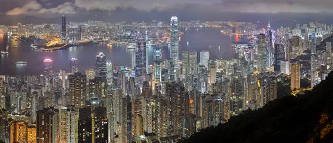
Photo: 毛貓大少爺, CC BY-SA 2.0, via Wikimedia Commons
Discover Kaohsiung
Kaohsiung is a big city on the island of Taiwan. It is by the sea.
Its harbor is the biggest international port in Taiwan.
Kaohsiung lies on the southwest coast of Taiwan. Its harbor is the largest international port in Taiwan, says the company that runs it, and Universalis calls it one of the island's leading export centers.
The census of 1 November 2020 counted 2,734,275 people in Kaohsiung City, which City Population lists as a special municipality made up of many districts. The photo shows the city at night in 2020, seen from high above.
Universalis: Kaohsiung (Gaoxiong in Mandarin), in southwest Taiwan, has a large international port; it overtook Keelung as Taiwan's first port, mainly because of its climate, and became a leading export center serving the farmland of the island's south and southeast. The Port of Kaohsiung calls itself the largest international port in Taiwan. City Population (from National Statistics): 2,734,275 in the special municipality of Kaohsiung City at the census of 1 November 2020 (permanent population), third among Taiwan's special municipalities after New Taipei (4,365,947) and Taichung (3,033,840).
- Located in
- southwest Taiwan (Universalis)
- People in Kaohsiung City (census, 1 November 2020)
- 2,734,275
- Port
- the largest international port in Taiwan (Port of Kaohsiung)
- Open to world trade
- since 1863 (Universalis)
A tall tower, a lighthouse and an island
Look at the tallest tower in the photo! It is called the Tuntex Sky Tower.
A lighthouse was built on a hill there in 1883.
Notes added to the photo on Wikimedia Commons name its tallest tower as the Tuntex Sky Tower and the wheel at the far left as the Kaohsiung Eye Ferris wheel.
The port's history says a lighthouse was built on Chihou Hill in November 1883. Across the harbor lies the island of Qijin. Since 1984, a four-lane tunnel under the harbor has joined it to the port.
Commons image notes by the uploader name four features in the 2020 photo, among them the Tuntex Sky Tower (Wikidata Q337631, about 0.45 km southeast of the city's Wikidata point) and the Kaohsiung Eye Ferris wheel. Port of Kaohsiung history: a lighthouse was built atop Chihou Hill in November 1883 (Wikidata's Kaohsiung Lighthouse, Q3847130, also gives 1883); the four-lane Cross Harbor Tunnel to Qijin island, built May 1981 to May 1984, is 1,550 m long. The port's location page also gives the address of the Kaohsiung Harbor Museum.
- Tallest tower in the photo
- the Tuntex Sky Tower (Commons image note)
- Lighthouse
- built on Chihou Hill in November 1883 (Port of Kaohsiung)
- Island across the harbor
- Qijin, reached by the Cross Harbor Tunnel (Port of Kaohsiung)
From fishing village to container port
Long ago, Kaohsiung was a small fishing village.
Later it grew into a busy port with many big ships.
The port's own history says the place where the port is now began as a small fishing village in the 16th century. In 1863 the harbor was opened to trade with other countries. Universalis says it was a fine natural harbor, but its narrow entrance had rocky reefs and had to be dredged.
Universalis says large harbor works were carried out from 1904 to 1907; the port's history gives a building plan in 1906 and a first phase from 1908 to 1912. Later, the port built its first container terminal in 1969 and 1970, and Universalis says it ranked 16th in the world for container traffic in 2007.
The Port of Kaohsiung's history: first settled as a fishing hamlet in the 16th century; Universalis: inhabited since the end of the Ming dynasty, with real settlement from the late 17th century. Opened to international trade in 1863 (both); the customs office is dated December 1863 by the port and 1864 by Universalis. Universalis: a splendid natural harbor whose narrow entrance, strewn with rocky reefs, had to be dredged; large harbor works 1904–1907 (the port's history: a construction plan in 1906, first phase 1908–1912). Port history: first container terminal 1969–1970; second harbor entrance 1967–1975, opening the inner harbor to ships up to the 100,000-ton class; Dazhen area (fifth container terminal) completed February 2001. Universalis: 16th in the world for container traffic in 2007.
- Opened to international trade
- 1863 (Universalis; Port of Kaohsiung)
- First container terminal
- built 1969–1970 (Port of Kaohsiung)
- Port rank for containers
- 16th in the world in 2007 (Universalis)
Railways, harbor entrances and a tunnel
Kaohsiung became the end of the main railway line across Taiwan.
A tunnel goes under the harbor to an island!
Universalis says Kaohsiung became the southern end of the main railway line that runs from the north to the south of Taiwan.
The port says a long, narrow sandbar separates the harbor from the open sea and works as a natural breakwater. Besides the First Harbor Entrance, a second entrance was built from 1967 to 1975. The Cross Harbor Tunnel, 1,550 meters long, carries traffic under the water to Qijin island.
Universalis: Kaohsiung became the southern terminus of the main railway line crossing the island from north to south. Port of Kaohsiung: a long, narrow sandbar separates the harbor from the open sea and acts as a natural breakwater; the First Harbor Entrance is at 22°37′01″ N, 120°15′25″ E; the second entrance (1967–1975) let cargo ships up to the 100,000-ton class into the inner harbor. The four-lane Cross Harbor Tunnel (May 1981 to May 1984) is 1,550 m long and reaches 14 m below the channel.
- Railway
- southern end of the main north–south line across Taiwan (Universalis)
- Cross Harbor Tunnel
- 1,550 meters long, finished in May 1984 (Port of Kaohsiung)
- Harbor shelter
- a long, narrow sandbar acts as a natural breakwater (Port of Kaohsiung)
Hot, rainy summers and dry winters
Kaohsiung is warm all year. Summer is hot and very rainy.
Winter is mild and dry.
The Central Weather Administration's averages for 1991 to 2020 show July days of about 33 °C and nights of about 27 °C. In January, days average about 24 °C and nights about 16 °C.
Most of the rain falls from May to September. August is the wettest month, with 512 millimeters, while February gets only about 18. Universalis says Kaohsiung's climate is the main reason its port overtook Keelung's.
Central Weather Administration monthly normals, Kaohsiung station, 1991–2020 (period as printed in each table): mean daily maximum 24.2 °C (Jan) to 32.7 °C (Jul); mean daily minimum 16.2 °C (Jan) to 26.7 °C (Jul). Precipitation 17.7 mm (Feb) to 512.4 mm (Aug); year 1,968.2 mm (the months add up to the same), of which May to September give 1,732.5 mm (88%). Precipitation days: 2.8 (Nov, Dec) to 16.7 (Aug); 87.3 in a year.
- July, average daily high and low (CWA, Kaohsiung, 1991–2020)
- 32.7 °C and 26.7 °C
- January, average daily high and low (same normals)
- 24.2 °C and 16.2 °C
- Rain in a year (CWA, 1991–2020)
- 1,968.2 mm, on about 87 days
Steel, ships and fishing boats
Kaohsiung makes steel and builds ships.
Fishing boats came to its harbor too.
Universalis calls Kaohsiung a large industrial city. Its Linhai Industrial Zone, finished in the mid-1970s along the quays, has a steelworks, shipyards and a petrochemical complex. A free zone opened in 1966 brought in companies from abroad that turn local raw materials into goods for export.
Universalis lists rice, sugar, bananas, pineapples, peanuts and citrus fruit among the main goods exported from Kaohsiung. It also says fishing boats that worked the waters of the Philippines and Indonesia came to use the harbor.
Universalis: a major industrial city; the Linhai Industrial Zone (2,225 ha, on the quays, completed in the mid-1970s) holds a steelworks, shipyards, a petrochemical complex and other industries; the city also has an oil refinery, an aluminum plant, a cement works, fertilizer plants, sugar refineries, a salt works and a paper mill. An industrial free zone opened in 1966 drew foreign firms that process local raw materials for export. Larousse: two export processing zones (steel, electronics, shipyards, oil refinery). Universalis lists rice, sugar, bananas, pineapples, peanuts and citrus among exports, and fishing boats working Philippine and Indonesian waters.
- Linhai Industrial Zone
- 2,225 hectares on the quays, finished in the mid-1970s (Universalis)
- Export processing zones
- two: steel, electronics, shipyards, oil refining (Larousse)
- Industrial free zone
- opened in 1966 (Universalis)
Kaohsiung on the map
Find the island of Taiwan on the globe. Kaohsiung is on its southwest coast.
Kaohsiung lies at about 22.6° north and 120.3° east, on the southwest coast of Taiwan. The port says it sits where the Taiwan Strait meets the Bashi Channel.
Measured from the city's center point on Wikidata, the Tuntex Sky Tower is about 0.5 kilometer southeast, the Kaohsiung Lighthouse about 3.3 kilometers west, and the First Harbor Entrance about 4.2 kilometers west.
Kaohsiung lies at about 22.62° N, 120.30° E (Wikidata point Q181557; the Natural Earth/sheet point is 3.77 km west-northwest of it). From the Wikidata point: Tuntex Sky Tower (Q337631) 0.45 km SE; Port of Kaohsiung (Q713449) 1.89 km W; Kaohsiung Lighthouse (Q3847130) 3.34 km W; Cijin Island (Q22087382, spelled Qijin by the port) 3.64 km SSW; First Harbor Entrance (22°37′01″ N, 120°15′25″ E, Port of Kaohsiung) 4.17 km W.
- Latitude
- about 22.6° north
- Longitude
- about 120.3° east
- Waters
- where the Taiwan Strait meets the Bashi Channel (Port of Kaohsiung)
Amazing facts
-
A tunnel with four lanes goes under Kaohsiung's harbor!
The Cross Harbor Tunnel, finished in 1984, runs 1,550 meters under the harbor to Qijin island, says the Port of Kaohsiung.
Port of Kaohsiung: the four-lane Cross Harbor Tunnel (May 1981 to May 1984) is 1,550 m long and reaches 14 m below the channel.
-
In Kaohsiung, August gets much more rain than winter months!
The Central Weather Administration's averages give Kaohsiung 512 millimeters of rain in August, but only about 18 in February.
CWA normals 1991–2020: August 512.4 mm, February 17.7 mm; May to September give 88% of the year's 1,968.2 mm.
-
A long strip of sand helps keep waves out of Kaohsiung's harbor!
The Port of Kaohsiung says a long, narrow sandbar separates its harbor from the open sea and works as a natural breakwater.
Port of Kaohsiung: a long, narrow sandbar separates harbor waters from the open sea and acts as a natural breakwater.
Words to know
- port
- a town or harbor where ships load and unload goods
- container
- a big metal box of a standard size used to carry goods on ships, trains and trucks
- breakwater
- a barrier that protects a harbor from waves
- sandbar
- a long ridge of sand built up in the water near a coast
- export
- a product sold and sent to another country
- census
- an official count of all the people in a country
Discovery challenge
-
Kaohsiung is a city on which island?
Kaohsiung lies on the southwest coast of which island?
Kaohsiung, opened to international trade in 1863, is a port on which island?
- Taiwan
- Iceland
- Madagascar
Show the answer
Taiwan
Taiwan!
Taiwan.
Taiwan (Universalis: southwest Taiwan).
-
Which month gets the most rain in Kaohsiung?
In the 1991–2020 averages, which is Kaohsiung's wettest month?
Which month has the highest mean precipitation in the CWA 1991–2020 normals for Kaohsiung?
- August
- January
- December
Show the answer
August
August!
August, with 512 millimeters.
August, 512.4 mm.
-
What goes under Kaohsiung's harbor to Qijin island?
What was finished in 1984 to link Qijin island with the port, under the water?
What 1,550-meter link under the harbor joined Qijin to the port in 1984?
- A tunnel
- A cable car
- A ski lift
Show the answer
A tunnel
A tunnel!
The Cross Harbor Tunnel.
The Cross Harbor Tunnel (Port of Kaohsiung).
-
When did Kaohsiung's harbor open to trade with other countries?
In which year was Kaohsiung's harbor opened to international trade?
In which year do Universalis and the port's history say the harbor opened to international trade?
- 1863
- 1663
- 1963
Show the answer
1863
In 1863!
1863.
1863.
Nearby places
-
 Watch
Landmark
Taipei 101
Taipei 101 is a skyscraper in Taipei, Taiwan, 508 meters tall with its spire and 101 stories high. When it opened, it was the tallest building in the world. Inside hangs a 660-ton steel ball, a tuned mass damper, that helps steady the tower in typhoon winds and earthquakes.
-
 Watch
City
Taipei
Taipei is a big city in the north of Taiwan, in a flat basin with rivers and hills. Its tower, Taipei 101, is 508 meters tall. Trains of the Taipei Metro carry people around the city, and its night markets are famous for snacks. About 2.4 million people were registered in Taipei City in September 2026.
-
 Watch
City
Hong Kong
Hong Kong, on the south coast of China, grew around one of the world's great natural harbors. It was a British colony for 156 years and has been a special administrative region of China since 1997. About 7.5 million people lived there in mid-2026.
-
 Watch
City
Macau
Macau is a small city on the south coast of China. It was a busy trading port under Portuguese administration from the mid-1500s until 1999, when it came under Chinese sovereignty. Its historic center, where Chinese and Portuguese buildings mix, is a UNESCO World Heritage Site.
-
 Watch
City
Guangzhou
Guangzhou, also known as Canton, is the capital of Guangdong Province in southern China. About 19.08 million people lived there in November 2025. For centuries it was a great port, and today its Canton Tower rises 600 meters.
-
 Watch
Landmark
Grand Canal
The Grand Canal is a huge system of man-made waterways in eastern China, running from Beijing in the north to Zhejiang province in the south. Parts were dug from the 5th century BC, and it was joined into one network in the 7th century AD. UNESCO calls it the longest and oldest canal in the world, and boats still use it today.
-
 Watch
City
Quezon City
Quezon City is a city in Metro Manila, in the Philippines, northeast of the city of Manila. The 2024 census counted 3,084,270 people there. It has a large university, a big nature park, busy shopping districts and a very rainy season.
-
 Watch
City
Shanghai
Shanghai is China's most populous city, on the coast where the great Yangtze River meets the East China Sea. Once a small fishing village, it grew into one of the world's busiest seaports. About 24.9 million people lived in Shanghai in 2020, and the towers of Pudong rise across the Huangpu River.
Explore next
-
Watch
 Country
Taiwan
Taiwan is an island in the western Pacific Ocean, about 160 kilometers off the coast of southeastern China. Mountains cover about two-thirds of it, and most of its 23 million people live on the flatter west side. It has its own government, based in Taipei. The People's Republic of China, governed from Beijing, says Taiwan is part of China, and Taiwan's status is disputed.
-
Watch
City
Taipei
Taipei is a big city in the north of Taiwan, in a flat basin with rivers and hills. Its tower, Taipei 101, is 508 meters tall. Trains of the Taipei Metro carry people around the city, and its night markets are famous for snacks. About 2.4 million people were registered in Taipei City in September 2026.
-
Watch
City
Hong Kong
Hong Kong, on the south coast of China, grew around one of the world's great natural harbors. It was a British colony for 156 years and has been a special administrative region of China since 1997. About 7.5 million people lived there in mid-2026.
-
 Watch
City
Abu Dhabi
Abu Dhabi is the capital of the United Arab Emirates. It began in the 1700s as a small settlement around fresh water on an island, guarded by a coral-stone watchtower. Before oil, it relied on fishing and pearl diving; since the 1960s, money from oil has turned it into a city of towers. An official estimate gave the city about 1.75 million people in 2023.
-
 Watch
City
Almaty
Almaty is the main city of Kazakhstan, in the southeast of the country at the foot of the Ala-Tau mountains. It was founded in 1854 where a Kazakh village called Almaty, 'village of apple trees', stood. It was the capital until 1998, and about 2,387,900 people lived there on 1 September 2026.
-
 Watch
City
Amman
Amman is the capital of Jordan, built on steep hills around a valley high on a plateau. Long ago it was a Roman city called Philadelphia, and its Roman theater, carved into a hillside, still holds about 6,000 people. Today the city spreads across the hills, with houses faced in pale stone. About 4.6 million people lived in Amman Governorate at the end of 2021.
-
 Watch
City
Ankara
Ankara is the capital of Türkiye, in the interior of Anatolia, about 200 kilometers from the Black Sea. People have lived here since the Stone Age, and Romans, Byzantines, Seljuks and Ottomans all left buildings behind. It became the capital in 1923, and today it is a city of government, universities and museums.
-
 Watch
City
Ashgabat
Ashgabat is the capital of Turkmenistan, in Central Asia. It lies at the foot of the Kopet Dag mountains, with the Karakum Desert to the north. The 2022 census counted 1,030,063 people, and Guinness World Records lists the city for its many white marble buildings.
For parents & teachers
What children will learn
- Locate Kaohsiung on the southwest coast of Taiwan.
- Explain how a sandbar can shelter a harbor.
- Describe what a container port does.
- Read a climate table with a wet summer and a dry winter.
Recommended ages: 3 to 17 · About 15 minutes
Talk about it
- Why might a harbor with a narrow, rocky entrance need dredging?
- Why do ports often have factories and shipyards right next to them?
- How does a tunnel under a harbor change life for people on an island?
Try at home or in class
- Sandbar test: in a tray of water, build a sand ridge and make waves to see the calm water behind it.
- Container stack: stack same-size boxes and count how many fit on a paper 'ship'.
- Rain chart: draw Kaohsiung's monthly rain as bars and color the wet May-to-September months.
Key vocabulary: port, container, breakwater, sandbar, export, census
Where these facts come from
- Wikidata , Wikimedia Foundation (CC0 1.0)
- Natural Earth vector data , Natural Earth (NACIS) (Public domain)
- Kaohsiung , Encyclopædia Universalis
- Kaohsiung ou Gaoxiong , Larousse encyclopédie
- Location , Port of Kaohsiung, Taiwan International Ports Corporation
- History , Port of Kaohsiung, Taiwan International Ports Corporation
- Taiwan: Administrative Division (Counties, Cities, Townships and Districts) , City Population (Thomas Brinkhoff), from the Ministry of Interior and National Statistics
- Monthly mean maximum temperature, 1991–2020 , Central Weather Administration
- Monthly mean minimum temperature, 1991–2020 , Central Weather Administration
- Monthly mean precipitation, 1991–2020 , Central Weather Administration
- Monthly mean precipitation days, 1991–2020 , Central Weather Administration
- File:Kaohsiung Skyline 2020.jpg (毛貓大少爺) , Wikimedia Commons
- Wikimedia Commons , Wikimedia Foundation (Per file (public domain, CC0, CC BY or CC BY-SA); see each media record)
Checked, not yet human-reviewed. Last updated November 1, 2026. Spotted a mistake? Tell us.