City Asia
Hong Kong
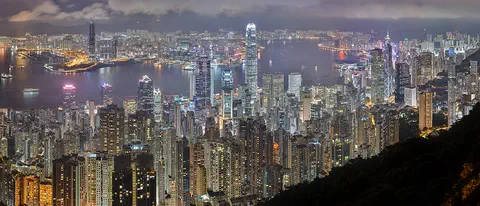
Hong Kong is a busy city by the sea in southern China. It has a big harbor, steep green hills and tall towers full of lights.
Hong Kong, on the south coast of China, grew around one of the world's great natural harbors. It was a British colony for 156 years and has been a special administrative region of China since 1997. About 7.5 million people lived there in mid-2026.
Hong Kong, whose name means "fragrant harbor", grew from a small fishing community into a world trade and financial center. A British crown colony from 1842, it became a special administrative region of China on July 1, 1997, under "one country, two systems"; its population was 7,518,300 in mid-2026.
Photo: Base64, retouched by CarolSpears, CC BY-SA 3.0, via Wikimedia Commons
Discover Hong Kong
Hong Kong is a big, busy city by the sea.
It is in southern China. Part of it is on an island. Tall towers stand along a wide harbor, and green hills rise behind them.
Hong Kong is on the south coast of China, at the eastern edge of the wide mouth of the Pearl River. It is made of Hong Kong Island, the southern part of the Kowloon Peninsula, a large mainland area called the New Territories, and about 230 offshore islands. About 7.5 million people lived there in mid-2026.
Its Chinese name means "fragrant harbor", and its deep, sheltered harbor is the reason the city grew. Hong Kong was ruled by Britain for 156 years. Since July 1, 1997, it has been a special administrative region of China, with its own laws and economy. Chinese and English are its official languages, and the most common language is Cantonese.
Hong Kong lies east of the Pearl River estuary on the south coast of China, bordered by Guangdong province to the north and the South China Sea on the other three sides; the city of Shenzhen lies immediately to the north. The provisional population at mid-2026 was 7,518,300, up 0.3 percent in a year, with a net inflow of residents but more deaths than births.
It became a special administrative region of China on July 1, 1997, after 156 years as a British crown colony. Under the "one country, two systems" principle in the Chinese-British joint declaration, it keeps a high degree of autonomy, including its capitalist economy and its own legal system, largely derived from British law, while China handles defense and foreign affairs. The region is led by a chief executive, under the jurisdiction of the central government in Beijing, and a Legislative Council. Chinese and English are official languages; Cantonese is the most widely spoken.
- Status
- special administrative region of China (since July 1, 1997)
- People (mid-2026)
- 7,518,300 (provisional)
- Name means
- "fragrant harbor"
- Official languages
- Chinese and English
Harbor, peak and ferries
Victoria Harbour lies between an island and the mainland.
Ferries go back and forth across it all day. A tall hill called the Peak looks down on the harbor. At night, the towers light up the water.
Victoria Harbour separates Hong Kong Island from Kowloon, and it is the heart of the city. The Star Ferry carries commuters across it, and National Geographic Traveler named the ride one of its "50 places of a lifetime".
Above the towers of Hong Kong Island rises Victoria Peak, 552 meters high. In the 1800s it was a lookout for incoming cargo ships, and later a cool summer retreat. A tram line up its steep slope made the Peak famous for its views, and today about 7 million people visit it each year.
The harbor, which made Hong Kong, was formed by the drowning of a granitic dome. The Victoria district on the northwestern coast of Hong Kong Island, where the British first landed in 1841, has been the center of government and business ever since. The Star Ferry, which calls its crossings an inexpensive and reliable part of the commuter system between the island and Kowloon, is also a major tourist attraction.
The Peak, at 552 m the highest point on Hong Kong Island, served as a signal post for incoming cargo ships in the 19th century; Governor Sir Richard MacDonnell built a summer home there around 1868. In 1881 Alexander Findlay Smith, formerly of Scotland's Highland Railway, petitioned for tram routes, including one to Victoria Gap; with reliable transport, the Peak became renowned for its views and now draws some 7 million visitors a year. The territory's highest point is Tai Mo Shan, 957 m, in the New Territories.
- Victoria Peak
- 552 m, highest on Hong Kong Island
- Visitors to the Peak
- about 7 million a year
- Highest point
- Tai Mo Shan, 957 m
Fishing port to world city
Long ago, Hong Kong was a fishing port.
Then ships came to trade, and the town grew fast. For many years Britain ruled Hong Kong. In 1997 Hong Kong became part of China again.
Hong Kong began as a fishing port. British forces landed on Hong Kong Island in 1841, and in 1842 China handed the island to Britain. Kowloon followed in 1860, and in 1898 the New Territories were leased to Britain for 99 years.
Japan occupied Hong Kong from 1941 until 1945. After the war, many people arrived from mainland China, and new factories, making textiles and other goods, gave them work. Hong Kong grew into a great center of trade and banking. In 1984 Britain and China signed an agreement, and on July 1, 1997, Hong Kong returned to Chinese sovereignty.
Britannica describes Hong Kong's original character as a fishing port. The British first landed on the island's northwest coast in 1841; after the First Opium War (1839–42) the island was ceded to Britain by the Treaty of Nanjing; after the Second Opium War, the Convention of Beijing (1860) added Kowloon south of present Boundary Street and Stonecutters Island, and in 1898 the New Territories and some 230 islands were leased for 99 years. Hong Kong prospered on its harbor and the China trade, which Britannica notes included opium dealing.
Japanese occupation began in 1941; British troops returned on August 30, 1945. Hundreds of thousands came back after the war, joined by refugees from China's civil war, and light industries such as textiles, set up by immigrant capitalists, drove recovery; from 1969 the territory also rose as a financial hub of the Asia-Pacific region. Talks over the expiring lease led to the joint declaration of December 19, 1984, and to the Basic Law, ratified on April 4, 1990, which took effect on July 1, 1997, establishing the Hong Kong Special Administrative Region.
Getting around Hong Kong
Hong Kong has fast trains, ferries and buses.
The trains are called the MTR. Ferries carry people across the harbor. Some fast trains go all the way into mainland China.
Hong Kong's railway, the MTR, has nine lines serving Hong Kong Island, Kowloon and the New Territories, plus a Light Rail network in Tuen Mun and Yuen Long and buses that link to the stations. Since September 2018, high-speed trains have run from West Kowloon Station into mainland China's national high-speed network.
The Star Ferry crosses Victoria Harbour between the island and Kowloon, and the Peak Tram climbs the steep hillside to Victoria Peak. Around the time of the handover, Hong Kong also put major resources into new bridges, roads and a new airport.
The MTR operates nine railway lines across Hong Kong Island, Kowloon and the New Territories, a Light Rail network for Tuen Mun and Yuen Long, and feeder buses. In September 2018 it opened the 26-km Hong Kong section of the Guangzhou-Shenzhen-Hong Kong High Speed Rail, which runs from West Kowloon Station and connects to the national high-speed network.
On the water, the Star Ferry links Hong Kong Island and Kowloon across Victoria Harbour. Britannica notes that, around the handover, major resources went into transport infrastructure, including new bridges and roadways and a new airport. (How people climb the island's slopes on outdoor escalators is told in the topic Living in a vertical city: Hong Kong.)
- MTR railway lines
- 9, plus a Light Rail network
- High-speed rail to mainland China
- since September 2018
Hot summers and typhoons
Hong Kong summers are hot, wet and sticky.
Sometimes big storms called typhoons bring strong winds and heavy rain. Winters are cool and dry. November and December are sunny and pleasant.
Hong Kong lies at the northern edge of the tropics. From May to August it is hot and humid, with afternoons often above 31 °C and nights around 26 °C. About 80 percent of the year's rain falls between May and September. Winters are cooler and drier, and many people think November and December are the best months, with breezes and plenty of sun.
From May to November, tropical cyclones can strike, most often from July to September. The strongest are called typhoons. Their heavy rain can last for days and cause landslips and floods. Frost sometimes forms on the hilltops in winter, but snow is rare.
Hong Kong lies at the northern fringe of the tropics, with well-marked monsoon seasons: hot, humid summers under warm, wet southeasterly winds and cool, dry winters under northeasterly winds from the cooling Asian landmass. Britannica gives mean temperatures of about 16 °C in January and 29 °C in July, and about 2,220 mm of rain a year. The Hong Kong Observatory notes that rainfall ranges from about 1,400 mm at Ping Chau to more than 3,000 mm near Tai Mo Shan, with about 80 percent from May to September.
About 30 tropical cyclones form in the western North Pacific or the China Seas each year, and about half reach typhoon strength, with maximum winds of 118 km/h or more; Britannica says an average of five or six affect Hong Kong. Their rain can last for days, and the Observatory warns that landslips and flooding sometimes do more damage than the winds.
- Average in January
- about 16 °C
- Average in July
- about 29 °C
- Typhoon season
- May to November, most often July to September
Living in Hong Kong
Most people in Hong Kong speak Cantonese.
Flat land is scarce, so some streets were built on land made from the sea. New towns have grown up on the mainland. Monkeys live in the green hills!
Cantonese is the language most people speak, and English is official too; Mandarin is used more and more. Because flat land is scarce, much of Hong Kong has been built on reclaimed land, ground made by filling in the sea. Many main streets on the north shore of Hong Kong Island stand on reclaimed land.
Since the 1970s, new towns such as Tai Po, Fanling and Yuen Long have grown up in the New Territories, each planned for 200,000 to 450,000 people. Away from the towers, the hills are green: rhesus macaques and another kind of monkey, neither of them native to Hong Kong, live in the forests of the New Territories.
Cantonese is the most common language, with Teochew, Hakka and Tanka spoken in particular communities, and Mandarin increasingly used since reunification. Lowlands, including floodplains, valleys and reclaimed land, make up less than a fifth of the land; many major streets on Hong Kong Island's north shore, the whole Kwun Tong industrial district and much of southern Kowloon stand on reclaimed land. New towns designated in the 1970s, such as Tai Po, Fanling, Yuen Long and Tseung Kwan O, were planned for 200,000 to 450,000 people each.
Britannica notes the lushness and diversity of Hong Kong's plants, though centuries of cutting and burning left only about one-sixth of the land forested; postwar planting restored stands of pine, eucalyptus, banyan, casuarina and palm. Two nonnative monkey species, including the rhesus macaque, flourish in New Territories forests, and marine fishing in nearby waters remains one of Hong Kong's most important primary activities.
Hong Kong on the map
Find Hong Kong on the globe.
It is on the south coast of China, in Asia. The sea is on three sides. There are lots of islands all around it.
Hong Kong is on the south coast of China, at the edge of the Pearl River estuary, where the river widens into the South China Sea. The sea surrounds it on the east, south and west, and the Chinese province of Guangdong lies to the north, with the big city of Shenzhen right next door.
Hong Kong Island is small, only about 81 square kilometers with the islets around it. Most of Hong Kong's land, more than 90 percent, is in the New Territories, on the mainland and the outlying islands. The land is rugged and steep, and it keeps growing as more land is reclaimed from the sea.
Hong Kong lies at about 22.3° N and 114.2° E, east of the Pearl River (Zhu Jiang) estuary. Hong Kong Island and its islets cover only about 81 km² and urban Kowloon with Stonecutters Island about 47 km²; the New Territories account for more than 90 percent of the total, which keeps growing through reclamation.
Its rugged relief, in sharp contrast to the low Pearl River Delta, belongs geologically to the eroded uplands of the South China massif: an upfold running northeast to southwest, formed about 150 million years ago late in the Jurassic Period. The harbor itself formed when a granitic dome was drowned by the sea.
- Latitude
- about 22.3° north
- Longitude
- about 114.2° east
- Hong Kong Island
- about 81 km² with nearby islets
- New Territories
- more than 90 percent of the land
Amazing facts
-
Hong Kong's name means "fragrant harbor".
In Chinese, Hong Kong (Xianggang) means "fragrant harbor". Its excellent natural harbor is the reason the city grew.
Xianggang, "fragrant harbor", developed first on its excellent natural harbor and the China trade, then on the labor and land of its expanded territory.
-
People once used Victoria Peak to watch for ships.
In the 1800s, Victoria Peak was a signal post that watched for cargo ships coming into the harbor.
At 552 m, the Peak served as a natural signaling post for incoming cargo ships in the 19th century before becoming a summer retreat.
-
Many Hong Kong streets are built on land made from the sea.
Many main streets on Hong Kong Island's north shore, and much of southern Kowloon, are built on reclaimed land, ground made by filling in the sea.
Major streets on Hong Kong Island's north shore, the entire Kwun Tong industrial district and much of the southern tip of the Kowloon Peninsula stand on reclaimed land.
-
In some places in Hong Kong, it rains twice as much as in others.
Rain is very uneven across Hong Kong: about 1,400 millimeters a year at Ping Chau, but more than 3,000 near Tai Mo Shan, the highest peak.
Mean annual rainfall ranges from about 1,400 mm at Ping Chau to more than 3,000 mm near Tai Mo Shan; June and August are usually the wettest months.
Words to know
- harbor
- a sheltered area of water where ships can safely stay
- special administrative region
- a part of China that keeps its own laws and economy under the national government
- colony
- a place ruled by a faraway country
- estuary
- the wide mouth of a river, where it meets the sea
- reclaimed land
- new land made by filling in part of the sea
- typhoon
- a powerful storm with very strong winds that forms over the western Pacific Ocean
Discovery challenge
-
What does the name Hong Kong mean?
What does the Chinese name Hong Kong mean?
What does the name Hong Kong (Xianggang) mean?
- Fragrant harbor
- Tall mountain
- Red river
Show the answer
Fragrant harbor
Fragrant harbor! A fragrant thing smells nice.
It means "fragrant harbor", and the harbor is why the city grew.
"Fragrant harbor"; the city developed on its excellent natural harbor and the China trade.
-
In which year did Hong Kong become part of China again?
In which year did Hong Kong return to Chinese sovereignty?
On July 1 of which year did Hong Kong become a special administrative region of China?
- 1842
- 1945
- 1997
Show the answer
1997
1997! Before that, Britain ruled Hong Kong.
On July 1, 1997, after 156 years as a British colony.
July 1, 1997, under the Basic Law and the 1984 joint declaration.
-
Which boat crosses Hong Kong's harbor?
Which ferry carries commuters across Victoria Harbour?
Which ferry service links Hong Kong Island and Kowloon across Victoria Harbour?
- The Star Ferry
- The Moon Ferry
- The Sun Ferry
Show the answer
The Star Ferry
The Star Ferry! It goes back and forth all day.
The Star Ferry, between Hong Kong Island and Kowloon.
The Star Ferry, part of the commuter system and a famous sightseeing trip.
-
What are the big storms that sometimes hit Hong Kong called?
What are the strongest tropical cyclones that can strike Hong Kong called?
What are tropical cyclones with maximum winds of 118 km/h or more called in the western North Pacific?
- Typhoons
- Blizzards
- Sandstorms
Show the answer
Typhoons
Typhoons! They bring strong winds and lots of rain.
Typhoons, which can arrive from May to November.
Typhoons; about half of the roughly 30 cyclones a year reach that strength, and five or six affect Hong Kong.
-
Which part of Hong Kong is the biggest?
Which part of Hong Kong covers more than 90 percent of its land?
Which part of the territory, leased in 1898, accounts for more than 90 percent of its area?
- Hong Kong Island
- Kowloon
- The New Territories
Show the answer
The New Territories
The New Territories! They are much bigger than the island.
The New Territories cover more than 90 percent of the land.
The New Territories, with some 230 islands, leased for 99 years from 1898.
Nearby places
-
 Watch
Natural wonder
Ha Long Bay
Ha Long Bay is a bay in northeast Vietnam where more than a thousand limestone islands rise straight out of the sea. Over millions of years, water dissolved the limestone into towers and caves, and then the sea flooded in around them. Together with the nearby Cat Ba Archipelago it is a World Heritage site.
-
 Watch
Landmark
Taipei 101
Taipei 101 is a skyscraper in Taipei, Taiwan, 508 meters tall with its spire and 101 stories high. When it opened, it was the tallest building in the world. Inside hangs a 660-ton steel ball, a tuned mass damper, that helps steady the tower in typhoon winds and earthquakes.
-
 Watch
Natural wonder
Son Doong Cave
Son Doong is a cave in the mountains of central Vietnam, inside Phong Nha–Ke Bang National Park. A river carved it, and its main passage is so wide and tall that a whole city block of skyscrapers could fit inside. Explorers first went in only in 2009. UNESCO says it holds the world's largest documented cave passage.
-
 Watch
Natural wonder
Phong Nha–Ke Bang National Park
Phong Nha–Ke Bang National Park, in central Vietnam near the border with Laos, protects one of the world's great limestone landscapes. UNESCO says its rocks began forming about 400 million years ago, and more than 220 kilometers of caves and underground rivers have been mapped. One of them, Son Doong, holds the world's largest known cave passage.
-
 Watch
Landmark
Three Gorges Dam
The Three Gorges Dam crosses the Yangtze River in central China. It is 2,335 meters long and 185 meters high, and it can make more electricity than any other hydroelectric dam in the world. It also lets big ships travel far up the river, but building it meant that more than a million people had to move.
-
 Watch
City
Shanghai
Shanghai is China's most populous city, on the coast where the great Yangtze River meets the East China Sea. Once a small fishing village, it grew into one of the world's busiest seaports. About 24.9 million people lived in Shanghai in 2020, and the towers of Pudong rise across the Huangpu River.
-
 Watch
Landmark
Terracotta Army
In 1974, farmers digging a well near Xi'an, China, found pieces of clay soldiers. Archaeologists uncovered an army of about 8,000 life-size soldiers and horses, made for the tomb of Qin Shi Huang, the first emperor of a united China, who died in 210 BCE. The figures were once brightly painted, and each has its own face.
-
 Watch
Landmark
Angkor Wat
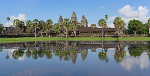
Angkor Wat, near the town of Siem Reap in Cambodia, was built in the 12th century by the Khmer king Suryavarman II. Britannica (2026) calls it the world's largest religious structure. It was built as a Hindu temple and later became a Buddhist place of worship.
Explore next
-
 Watch
 Country
China
China is the largest country in Asia, almost as big as all of Europe. The land steps down from the high, cold Plateau of Tibet in the west to plains and coasts in the east, and about 1.4 billion people live there, along with giant pandas in the mountains of south-central China.
-
Watch
Life around the world
Living in a vertical city: Hong Kong
Hong Kong is hilly, and only about a quarter of its land is built on. Its 7.5 million people live close together, many in apartment buildings. A long chain of outdoor escalators climbs one hillside, ferries cross Victoria Harbour, and trains carry millions of passengers every day.
-
 Watch
City
Beijing
Beijing, the capital of China, has been the country's capital for most of the last 600 years. At its heart is the Forbidden City, the emperors' palace. About 21.8 million people lived in the Beijing municipality at the end of 2024.
- Watch Geography Islands An island is a piece of land surrounded by water that is smaller than a continent. Islands form in different ways: some broke away from continents, some were built by volcanoes on the sea floor, and some were made by corals or by waves piling up sand. Because they are cut off by water, islands often have unusual plants and animals.
-
 Watch
City
New York City
New York City sits where the Hudson River meets a great harbor on the Atlantic coast. It has been the largest city in the United States since 1790. About 8.8 million people lived in its five boroughs in 2020, among skyscrapers, bridges and parks.
-
 Watch
City
Bangkok
Bangkok, the capital of Thailand, lies on the delta of the Chao Phraya River, about 40 kilometers from the sea. It became the capital in 1782, when the new royal palace and temples were built. Once called the 'Venice of the East' for its canals, it is now a huge, busy city with skyscrapers and an elevated railway.
-
Watch
City
Shanghai
Shanghai is China's most populous city, on the coast where the great Yangtze River meets the East China Sea. Once a small fishing village, it grew into one of the world's busiest seaports. About 24.9 million people lived in Shanghai in 2020, and the towers of Pudong rise across the Huangpu River.
-
 Watch
City
Ankara
Ankara is the capital of Türkiye, in the interior of Anatolia, about 200 kilometers from the Black Sea. People have lived here since the Stone Age, and Romans, Byzantines, Seljuks and Ottomans all left buildings behind. It became the capital in 1923, and today it is a city of government, universities and museums.
For parents & teachers
What children will learn
- Locate Hong Kong on the south coast of China at the Pearl River estuary.
- Explain in plain terms how Hong Kong changed from a British colony to a special administrative region of China.
- Describe how a crowded, hilly city moves people by rail, ferry and tram.
- Explain what typhoons are and when they reach Hong Kong.
Recommended ages: 3 to 17 · About 15 minutes
Talk about it
- Hong Kong grew because of its harbor. What natural features helped your town grow?
- Much of Hong Kong is built on land made from the sea. What might be good and difficult about building on reclaimed land?
- How might a city get ready for a typhoon?
Try at home or in class
- In a tray, press sand or clay into a hilly island, then add more sand along one edge to "reclaim" flat land, and talk about where you would build.
- Track the weather for a week and compare it with Hong Kong's: is it warmer or cooler, wetter or drier?
Key vocabulary: harbor, special administrative region, colony, estuary, reclaimed land, typhoon
Where these facts come from
- Wikidata , Wikimedia Foundation (CC0 1.0)
- Natural Earth vector data , Natural Earth (NACIS) (Public domain)
- Hong Kong , Encyclopaedia Britannica
- Hong Kong: Climate and plant and animal life , Encyclopaedia Britannica
- Hong Kong: Settlement patterns , Encyclopaedia Britannica
- Hong Kong: Postwar Hong Kong and return to Chinese sovereignty , Encyclopaedia Britannica
- Hong Kong: Government and society , Encyclopaedia Britannica
- Provisional figure of Hong Kong population at mid-2026 (press release, 18 August 2026) , Census and Statistics Department, Hong Kong SAR Government
- Climate of Hong Kong , Hong Kong Observatory
- Corporate profile , MTR Corporation
- Star Ferry , The "Star" Ferry Company, Limited
- History of The Peak , The Peak Tram (official site)
- Opium Wars , Encyclopaedia Britannica
- Wikimedia Commons , Wikimedia Foundation (Per file (public domain, CC0, CC BY or CC BY-SA); see each media record)
Checked, not yet human-reviewed. Last updated October 27, 2026. Spotted a mistake? Tell us.