
City Africa
Lilongwe
Lilongwe is the capital of Malawi, a country in Africa. It sits high up on a flat land called a plateau.
Lilongwe is the capital of Malawi, in southern Africa. It grew from a market village, and a new capital city was built next to it and opened in 1975. It lies on a high plateau about 1,100 meters above sea level, and Malawi's statistics office projected 1,162,500 people for it in 2023.
Lilongwe, Malawi's capital since 1975, joins a colonial market center developed from 1947 (Old Town) and a planned capital launched in 1964 (Capital City) about 5 km to the north, separated by the Lilongwe Nature Sanctuary. On a plateau at about 1,100 m, it grew from 20,000 people in 1964 to 989,318 at the 2018 census; the National Statistical Office's projection for 2023 is 1,162,500.
Photo: Brian Dell, public domain, via Wikimedia Commons
Discover Lilongwe
Lilongwe is the capital of Malawi. Malawi is a country in the south of Africa.
More people live in Lilongwe than in any other city in Malawi.
Lilongwe is the capital of Malawi, Universalis says. It lies in Malawi's Central Region, on a high plateau about 1,100 meters above sea level.
At the 2018 census, 989,318 people lived in the city. Malawi's National Statistical Office projected 1,162,500 people for 2023, more than in any other city in Malawi; Blantyre came next, with 871,800.
National Statistical Office of Malawi (via City Population): Lilongwe city 102,924 (1977), 223,318 (1987), 440,471 (1998), 674,448 (2008) and 989,318 at the census of 3 September 2018; the projection for 3 September 2023 is 1,162,500, rank 1 among Malawi's major cities, ahead of Blantyre (871,800), Mzuzu (273,000) and Zomba (116,800).
Universalis: the political capital of Malawi, in the Central Region, on a high plateau at 1,100 m; one of the few new African cities built to become post-colonial capitals.
- Country
- Malawi (capital)
- People in Lilongwe (projection, 2023)
- 1,162,500
- People in Lilongwe (census, 3 September 2018)
- 989,318
- Height above sea level
- about 1,100 m, on a high plateau
A street in Old Town
Look at this wide road! White minibuses and cars drive past shops.
This part of the city is called Area 2. Many parts of Lilongwe have numbers for names.
This photo was taken on 15 October 2008 from a bridge for people on foot, looking east into Area 2 of Old Town, the photographer wrote. Lilongwe has about fifty neighborhoods called areas, each known by a number, Universalis says.
In the picture, minibuses and cars drive along a wide road past traffic lights and a row of shops. People walk on the red earth beside the road, and a white minaret with domes rises on the skyline.
Commons: 'Lilongwe Area 2', 15 October 2008, own work by Brian Dell, released into the public domain; description: view east into Area 2 of Old Town Lilongwe, from a pedestrian overpass, with the Lilongwe River running north-south 100 or 150 m behind the camera (altimeter 1,055 m). The camera's recorded position is about 0.65 km ESE of the city's Wikidata point.
In the picture: a wide road with minibuses, cars and a pickup truck; traffic lights; a row of shops with painted signs; pedestrians on red earth verges; trees at left; on the skyline, a white minaret and domes. Universalis: the city is divided into about fifty neighborhoods called areas, designated by numbers.
- Photo
- view east into Area 2 of Old Town, 15 October 2008
- Taken from
- a pedestrian overpass, with the Lilongwe River 100 or 150 m behind the camera (the photographer's description)
- Neighborhoods
- about fifty, called areas, each with a number
A market town and a new capital
Lilongwe was once a small village with a market. Later, a new capital was built next to it. It opened in 1975.
Lilongwe began as a village. From 1947, the British developed it as a market for the thriving farming region around it, where many people lived, Universalis says. This older part is now called Old Town.
Malawi became independent in 1964, and that year the plan for a new capital was launched. The new capital opened in 1975, north of Old Town, and took over from Zomba, the old capital in the south. In 1982 an international airport was added.
Universalis: the former village of Lilongwe was developed from 1947 by the British as a market for a dynamic and densely settled farming region. Malawi, a former British colony, became independent in 1964. The new capital, launched in 1964, was inaugurated in 1975, replacing the old colonial administrative capital of Zomba in the south; in 1982 an international airport was added, at the same time as a railway linked the city to Malawi's other urban centers.
Lilongwe is therefore not 'new' in the strict sense: the planned capital (New Town or Capital City) was built north of the colonial center (Old Town).
- Old Town
- a village developed from 1947 as a market for a farming region
- New capital
- launched in 1964, inaugurated in 1975
- Capital before Lilongwe
- Zomba, in the south of Malawi
Two towns and a park between them
Lilongwe has two parts: Old Town and the newer Capital City. A large nature park lies between them.
Lilongwe has two main parts about 5 kilometers apart, Universalis says: the densely built Old Town and the newer Capital City to the north, with homes, a district of government ministries and office buildings on Capital Hill. Between them lies a large natural park, the Lilongwe Nature Sanctuary.
Lilongwe International Airport lies about 22 kilometers north of the city's center point on Wikidata, at 1,230 meters above sea level.
Universalis: north of the dense colonial center (Old Town), the new capital (New Town or Capital City) was built as a vast, very open urban area of residential zones, a ministries quarter and administrative buildings on Capital Hill; the two, 5 km apart, are separated by a large natural park, the Lilongwe Nature Sanctuary. A railway linked the city to Malawi's other urban centers from 1982.
Wikidata (from the city's point, Q3876): Lilongwe Wildlife Centre (Q23808334), a wildlife sanctuary, 2.32 km NE; Lilongwe Nature Sanctuary (Q131470591) 2.85 km NE; Lilongwe International Airport (Q721780), elevation 1,230 m, 21.97 km N.
- Old Town to Capital City
- about 5 km, with the Lilongwe Nature Sanctuary between them
- Lilongwe International Airport
- about 22 km north of the city's Wikidata point, 1,230 m high (Wikidata)
- Capital Hill
- a ministries quarter and government office buildings
Coolest in July, warmest in November
Lilongwe is mild or warm all year. June and July are the coolest months.
October and November are the warmest.
The Japan Meteorological Agency's averages for 1991 to 2020, from a weather station at Lilongwe 1,229 meters above sea level, show mild to warm weather all year. The average temperature is lowest in July, at 16.0 °C, and highest in November, at 23.6 °C, with October close behind at 23.4 °C.
From January to March, the average stays at 21.3 °C each month.
Japan Meteorological Agency, world climate normals 1991–2020, Lilongwe (13.78° S, 33.77° E, 1,229 m): monthly mean temperature 21.3, 21.3, 21.3, 20.1, 18.3, 16.5, 16.0, 17.6, 20.7, 23.4, 23.6, 22.2 °C (January to December). The coolest months are June (16.5 °C) and July (16.0 °C); the warmest are October (23.4 °C) and November (23.6 °C). The table gives no rainfall figures.
The station's position and height match closely those of Lilongwe International Airport on Wikidata (1,230 m), about 22 km north of the city's point.
- Warmest months (average temperature, 1991–2020)
- 23.6 °C (November), 23.4 °C (October)
- Coolest month (same normals)
- 16.0 °C (July)
- Weather station
- Lilongwe, 1,229 m above sea level
Water, power and work
Lilongwe gets its water from a river. The river also helps make electricity for the city.
Lilongwe gets its water from the Lilongwe River, which has been set up to make hydroelectric power for the capital too, Universalis says. Industries have grown up in the city too: machinery, textiles and food processing.
The city has grown quickly. About 20,000 people lived there in 1964, about 150,000 in 1990 and nearly 750,000 in 2005, figures from Malawi's statistics office that Universalis reports.
Universalis: Lilongwe is supplied with water by the river of the same name, developed to also produce the hydroelectricity the capital needs; industry has developed (mechanical engineering, textiles, food processing). Population: 20,000 in 1964, 150,000 in 1990, nearly 750,000 in 2005 (National Statistical Office of Malawi, as cited).
Census counts for the city (via City Population): 440,471 (1998), 674,448 (2008), 989,318 (2018).
- Water
- from the Lilongwe River, which also makes hydroelectricity for the capital
- Industries
- machinery, textiles and food processing
- Growth
- 20,000 people (1964), 150,000 (1990), nearly 750,000 (2005)
Lilongwe on the map
Find Malawi on the globe, in the south of Africa. Lilongwe is in the middle of the country.
Lilongwe lies at about 14° south and 33.8° east, in Malawi's Central Region, on a high plateau about 1,100 meters above sea level.
Measured from the city's center point on Wikidata, the Lilongwe Wildlife Centre is about 2.3 kilometers northeast and the Lilongwe Nature Sanctuary about 2.9 kilometers northeast. The airport is about 22 kilometers north, and the Dzalanyama Forest Reserve, a protected forest, about 45 kilometers southwest.
Lilongwe lies at about 13.98° S and 33.78° E (Natural Earth point, 1.68 km ENE of the Wikidata point). From the Wikidata point (Q3876): Lilongwe Wildlife Centre 2.32 km NE, Lilongwe Nature Sanctuary 2.85 km NE, Lilongwe International Airport 21.97 km N, Dzalanyama Forest Reserve (Q131549345) 45.12 km SW.
City Population lists Lilongwe in the Central Region (CEN), which had 7,523,340 people at the 2018 census.
- Latitude
- about 14.0° south
- Longitude
- about 33.8° east
- Region
- Central Region of Malawi
Amazing facts
-
Many parts of Lilongwe have numbers instead of names, like Area 2.
Lilongwe is divided into about fifty neighborhoods called areas, each known by a number, Universalis says. The photo on this page shows Area 2.
Universalis: the city is divided into about fifty neighborhoods called areas, designated by numbers.
-
A nature park lies between the old part and the new part of Lilongwe.
Old Town and Capital City, about 5 kilometers apart, are separated by a large natural park, the Lilongwe Nature Sanctuary, Universalis says.
Universalis: the two towns, 5 km apart, are separated by a vast natural park (Lilongwe Nature Sanctuary).
-
Lilongwe once had only about 20,000 people. Now it has about a million!
About 20,000 people lived in Lilongwe in 1964, Universalis says. At the 2018 census there were 989,318.
Universalis: 20,000 inhabitants in 1964; NSO census of 3 September 2018 (via City Population): 989,318.
-
Lilongwe's river gives the city water and helps make electricity.
The Lilongwe River supplies the city with water and has been set up to make hydroelectric power for the capital too, Universalis says.
Universalis: the river of the same name supplies the city with water and was developed to produce the capital's hydroelectricity.
Words to know
- capital
- the city where a country's government works
- plateau
- a large area of high, mostly flat land
- planned city
- a city designed and built on purpose, often all at once
- hydroelectricity
- electricity made from moving water
- projection
- a careful estimate of a future number, made from earlier counts
- census
- an official count of all the people in a place
Discovery challenge
-
Lilongwe is the capital of which country?
Lilongwe is the capital of which country in southern Africa?
Inaugurated as a capital in 1975, Lilongwe is the capital of which country?
- Malawi
- Peru
- Norway
Show the answer
Malawi
Malawi!
Malawi.
Malawi.
-
Which city was the capital before Lilongwe?
Which city in southern Malawi was the capital before Lilongwe?
Lilongwe replaced which colonial administrative capital in 1975?
- Zomba
- Nairobi
- Cairo
Show the answer
Zomba
Zomba!
Zomba.
Zomba, in the south.
-
When did the new capital open?
In which year was Lilongwe's new capital inaugurated?
Launched in 1964, the new capital was inaugurated in which year?
- 1975
- 1875
- 2005
Show the answer
1975
1975!
1975.
1975.
-
What lies between the old and new parts of Lilongwe?
What separates Old Town from Capital City?
According to Universalis, what separates Old Town and Capital City, 5 km apart?
- A nature park
- A big lake
- A desert
Show the answer
A nature park
A nature park!
The Lilongwe Nature Sanctuary.
The Lilongwe Nature Sanctuary, a large natural park.
-
Which is the coolest month in Lilongwe?
In the JMA averages, which month is the coolest?
JMA 1991–2020: which month has the lowest mean temperature, 16.0 °C?
- July
- November
- January
Show the answer
July
July!
July.
July (16.0 °C).
Nearby places
-
 Watch
Natural wonder
Lake Malawi
Lake Malawi is one of the African Great Lakes, in the Great Rift Valley. UNESCO calls it one of the deepest lakes in the world, and it holds many hundreds of kinds of cichlid fish, nearly all found nowhere else.
-
 Watch
Landmark
Kariba Dam
The Kariba Dam is a curved concrete dam across the Zambezi River, between Zambia and Zimbabwe. It is 128 meters high. It was built between 1956 and 1960, and its lake, Lake Kariba, is 280 kilometers long. Two power stations use the water to make electricity.
-
 Watch
City
Lusaka
Lusaka is the capital of Zambia, an African country with no coast. Zambia's 2022 census counted 2,212,301 people in the city, by far the most in the country. Lusaka was planned in the 1930s as a new capital and officially opened in 1935.
-
 Watch
Natural wonder
Selous Game Reserve
The Selous Game Reserve in Tanzania is one of the largest protected areas in Africa. UNESCO says it holds some of the most important groups of elephants, black rhinos, cheetahs, giraffes, hippos and crocodiles.
-
 Watch
Landmark
Great Zimbabwe
Great Zimbabwe is the ruin of a great stone city in southern Africa, built by the Shona people between about 1100 and 1450. Its walls of granite blocks were laid without mortar. At its height it was the capital of a large state, with more than 10,000 people, and it traded gold for goods from as far away as China.
-
 Watch
Natural wonder
Victoria Falls
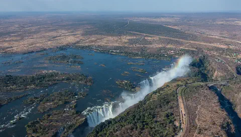
Victoria Falls, on the Zambezi River between Zambia and Zimbabwe, is about 1,708 meters wide and up to 108 meters deep. UNESCO calls it the largest curtain of falling water in the world, and its spray can be seen from tens of kilometers away.
-
 Watch
Natural wonder
Lake Tanganyika
Lake Tanganyika lies in a deep crack in Africa called a rift valley. Britannica calls it the longest freshwater lake in the world, and only Lake Baikal, in Russia, is deeper. Four countries share it: Tanzania, the Democratic Republic of the Congo, Burundi and Zambia. Its water is home to about 250 kinds of cichlid fish found nowhere else.
-
 Watch
City
Dar es Salaam
Dar es Salaam is the largest city of Tanzania, on the coast of the Indian Ocean in East Africa. It was founded in 1862 beside a harbor that was good for ships. In the 2022 census, 5,383,728 people were counted there.
Explore next
-
 Watch
 Country
Malawi
Malawi is a narrow country in southeastern Africa that curves along the Great Rift Valley. Lake Malawi, one of the deepest lakes in the world, covers more than a fifth of the country, and it is home to hundreds of kinds of colorful fish. About 21 million people lived there in 2026.
-
Watch
City
Lusaka
Lusaka is the capital of Zambia, an African country with no coast. Zambia's 2022 census counted 2,212,301 people in the city, by far the most in the country. Lusaka was planned in the 1930s as a new capital and officially opened in 1935.
-
 Watch
City
Maputo
Maputo is the capital of Mozambique, on a bay of the Indian Ocean in the far south of the country. Mozambique's statistics office projected 1,133,200 people in Maputo City in 2023. Until 1976 the city was called Lourenço Marques.
-
 Watch
City
Antananarivo
Antananarivo, once called Tananarive, is the capital of Madagascar. Madagascar's 2018 census counted 1,274,225 people in the city, almost four times as many as in Toamasina, the next city. It lies about 1,250 meters up in the island's highlands, and rice fields still mark its edges.
-
 Watch
City
Abidjan
Abidjan is the largest city of Côte d'Ivoire, with 5,616,633 people at the 2021 census. Spread around the Ébrié Lagoon, it grew from a colonial port: a canal finished in 1950 opened the lagoon to ships, and its Plateau district is a cluster of office towers, banks and government buildings.
-
 Watch
City
Abuja
Abuja is the capital of Nigeria, in the middle of the country. It was planned from the start: in 1976 the government decided to build a new capital on the savanna, and in 1991 it moved there from Lagos. Planners set aside land for parks and green spaces, and the huge Aso Rock rises at the city's edge.
-
 Watch
City
Accra
Accra is the capital of Ghana, on the coast of West Africa. It began as a small village of the Ga people beside the Korle Lagoon. Three old forts built by European traders still stand by the sea. More than 5.4 million people lived in the Greater Accra Region at the 2021 census.
-
 Watch
City
Addis Ababa
Addis Ababa is the capital of Ethiopia, high in the hills of East Africa at about 2,355 meters. It was founded in the 1880s, and its name means 'new flower' in Amharic. Electric light-rail trains cross the city, and its National Museum shows a copy of Lucy, a famous fossil 3.2 million years old.
For parents & teachers
What children will learn
- Locate Lilongwe in central Malawi.
- Describe how a planned capital was built next to an older market town.
- Read a table of monthly temperatures and find the coolest and warmest months.
- Compare census counts to see how fast a city has grown.
Recommended ages: 3 to 17 · About 15 minutes
Talk about it
- Why might a country build a brand-new capital city?
- What would it be like to live in a neighborhood with a number instead of a name?
- Lilongwe is in the tropics, but its coolest month is July. Why might that be?
Try at home or in class
- Growth chart: draw bars for Lilongwe's census counts from 1977 to 2018 and see how the city grew.
- Plan a capital: draw a city with homes, offices and a park, and choose where each goes.
- Number town: make a map where each neighborhood has a number, then give a friend directions.
Key vocabulary: capital, plateau, planned city, hydroelectricity, projection, census
Where these facts come from
- Wikidata , Wikimedia Foundation (CC0 1.0)
- Natural Earth vector data , Natural Earth (NACIS) (Public domain)
- Lilongwe , Encyclopaedia Universalis
- Malawi: Regions, Major Cities & Urban Localities , City Population (Thomas Brinkhoff), from the National Statistical Office of Malawi
- Lilongwe: monthly climate normals 1991–2020 , Japan Meteorological Agency
- File:Lilongwe Area 2.jpg (Brian Dell, 15 October 2008) , Wikimedia Commons
- Wikimedia Commons , Wikimedia Foundation (Per file (public domain, CC0, CC BY or CC BY-SA); see each media record)
Checked, not yet human-reviewed. Last updated November 1, 2026. Spotted a mistake? Tell us.
Picture credits
- Photo: Brian Dell, public domain, via Wikimedia Commons · source