
City Africa
Lusaka
Lusaka is the capital city of Zambia, in Africa. It has tall office towers and a big main road called Cairo Road.
Lusaka is the capital of Zambia, an African country with no coast. Zambia's 2022 census counted 2,212,301 people in the city, by far the most in the country. Lusaka was planned in the 1930s as a new capital and officially opened in 1935.
Lusaka was planned as the new capital of the British protectorate of Northern Rhodesia and officially opened in 1935; in 1964 Northern Rhodesia became independent Zambia, whose capital it is today. The 2022 census counted 2,212,301 people, more than three times Kitwe, the next city.
Photo: Matthew Grollnek, CC BY-SA 4.0, via Wikimedia Commons
Discover Lusaka
Lusaka is the capital city of Zambia. Zambia is a country in Africa, far from the sea.
More than two million people live in Lusaka.
Lusaka is the capital of Zambia, a country in Africa. Zambia's census of August 2022 counted 2,212,301 people in the city, more than three times as many as Kitwe, the next-biggest city.
Universalis says Zambia has no coast: it is surrounded by eight other countries, and most of it is a huge high plateau.
City Population (Central Statistical Office, Zambia) gives Lusaka 769,353 people in the 1990 census, 1,084,703 in 2000, 1,747,152 in 2010 and 2,212,301 on 18 August 2022, first in Zambia ahead of Kitwe (665,961) and Ndola (627,503). Lusaka Province had 3,093,615 in 2022.
Universalis (Zambia): a landlocked plateau of 753,000 km², mostly 900 to 2,100 m high, with a tropical climate.
- Country
- Zambia (its capital)
- People in Lusaka (census, 18 August 2022)
- 2,212,301
- Next-biggest city (same census)
- Kitwe, 665,961
- Officially opened as the new capital
- 1935
Downtown by the roundabout
Look at the tall tower on the right! A big blue sign sits on its top.
In the middle, water splashes from a tall column with a bird on top.
This photo shows downtown Lusaka from the roundabout at the south end, on 8 December 2013. The tall tower on the right is Findeco House, a skyscraper of 25 floors. In the middle, a fountain sprays from a tall dark column topped by a bird sculpture, and office blocks stand behind green bushes and trees.
Wikidata calls Cairo Road, a short walk away, Lusaka's main street and its main business, shopping and services center.
Commons: 'Downtown Lusaka showing the Findeco Building from the south end round-a-bout', 8 December 2013, own work by Matthew Grollnek (CC BY-SA 4.0); categories 'Findeco House', 'Views of Lusaka'.
Wikidata: FINDECO House, a skyscraper of 25 floors; Cairo Road, Lusaka's main thoroughfare, 0.88 km NNW of Findeco House.
- Photo
- downtown Lusaka from the south-end roundabout, 8 December 2013
- Findeco House
- a skyscraper of 25 floors
- Cairo Road
- the city's main street and business center, about 900 m north-northwest of Findeco House
A capital planned with trees
About 90 years ago, people drew a plan for a new capital city here. They planned lots of trees and green spaces.
Later, Lusaka became the capital of a new country: Zambia.
A book from TU Delft's press tells how Lusaka was planned in the 1930s as the new capital of Northern Rhodesia, then a British territory, and officially opened in 1935. The planners paid special attention to public buildings, landscaping and tree planting, and gave priority to a new airport.
Universalis says that on 24 October 1964 Northern Rhodesia became the independent country of Zambia. Lusaka is its capital today.
Robert Home's account (TU Delft BK Books) of Lusaka's planning, written for its official opening in 1935: a prestige project of the 1930s, presented as British garden-city planning applied overseas; Lusaka lay on the projected 'Cape to Cairo' railway at a time of fast copper-mining growth in the Copperbelt.
Universalis (Zambia): colonization began in 1890 under Cecil Rhodes's British South Africa Company, which dreamed of a Cape-to-Cairo line passing through Lusaka; 1927 marked the start of the copper boom.
- Planned as the new capital of Northern Rhodesia
- 1930s; officially opened 1935
- Zambia becomes independent
- 24 October 1964
- On the planned Cape-to-Cairo railway
- yes
Cairo Road and the airport
Cars and buses drive along Cairo Road, Lusaka's main street. Planes land at an airport outside the city.
Cairo Road is Lusaka's main street and its main center for business, shops and services, Wikidata says. Lusaka also lay on a railway once planned to run all the way from the Cape to Cairo.
Lusaka's international airport lies about 21 kilometers east-northeast of Findeco House. In the 1930s the city's planners made a new airport a priority, as air travel was growing fast.
Wikidata: Cairo Road, main thoroughfare and principal business, retail and services center; the international airport, 20.9 km ENE of Findeco House.
TU Delft synopsis: the 1930s plan gave priority to the new airport, reflecting the great expansion of air networks in that decade; Universalis (Zambia): the landlocked country has a major problem moving its goods to the sea.
- Cairo Road
- main thoroughfare of the city
- International airport
- about 21 km east-northeast of Findeco House
- Railway
- Lusaka lay on the projected Cape-to-Cairo line
A rainy season and a dry season
In Lusaka, lots of rain falls from November to March. From May to September it hardly rains at all.
October is the hottest month.
The World Meteorological Organization's averages for Lusaka give about 798 millimeters of rain in a year. January is the wettest month, with 229 millimeters, while June, July and August average no rain at all.
October is the hottest month, with highs of about 31 °C. July is the coolest, with nights of about 10 °C.
WMO World Weather Information Service, Lusaka (no averaging period given): rainfall 798 mm, from 229 mm in January, 183 mm in December and 179 mm in February to 0 mm in June, July and August; November to March bring 753 mm. Average highs 23.0 °C (July) to 30.8 °C (October); average lows 10.2 °C (July) to 17.9 °C (November).
Universalis calls Zambia's climate tropical.
- October, average high (WMO)
- 30.8 °C
- July, average low (same table)
- 10.2 °C
- Rainfall, June to August
- 0 mm
Copper, museums and parks
Lusaka has a national museum. Not far away there are a national park and an animal park.
The Lusaka National Museum opened in 1996, Wikidata says. Farther out, Lusaka National Park lies about 14 kilometers southeast of Findeco House, and the Munda Wanga Environmental Park, an animal park and wildlife sanctuary, about 15 kilometers south.
Universalis says the copper-mining boom that began in 1927 marked Zambia's entry into the modern era, and that most town dwellers then lived in the Copperbelt, in the northeast of the country.
Wikidata: Lusaka National Museum (1996); Lusaka National Park 13.6 km SE of Findeco House; Munda Wanga Environmental Park, animal park and wildlife sanctuary, 15.3 km S.
Universalis (Zambia): about 35% of people lived in towns, mostly in the Copperbelt, making Zambia one of Africa's most urbanized countries.
- Lusaka National Museum
- opened 1996 (Wikidata)
- Lusaka National Park
- about 14 km southeast of Findeco House
- Munda Wanga Environmental Park
- an animal park and wildlife sanctuary, about 15 km south
Lusaka on the map
Find Africa on the globe. Zambia is south of the equator, with no sea. Lusaka is its capital.
Lusaka lies at about 15.4° south, on the high plateau of Zambia, a country surrounded by eight others. Measured from Findeco House, Cairo Road is about 900 meters north-northwest and the international airport about 21 kilometers east-northeast.
Lusaka National Park is about 14 kilometers to the southeast.
Lusaka lies at about 15.42° S and 28.28° E. From Findeco House (Wikidata points): Lusaka's own point 0.85 km N, Cairo Road 0.88 km NNW, Lusaka National Park 13.6 km SE, Munda Wanga 15.3 km S, the airport 20.9 km ENE.
Universalis: Zambia lies where Central Africa meets southern Africa.
- Latitude
- about 15.4° south
- Longitude
- about 28.3° east
- Setting
- on the high plateau of a landlocked country
Amazing facts
-
Lusaka was planned with lots of trees!
The people who planned Lusaka in the 1930s gave special attention to landscaping and tree planting, a TU Delft book says.
Robert Home (TU Delft BK Books): particular features of Lusaka's planning were public buildings, landscaping and tree planting, and priority for the new airport.
-
Lusaka's main street is called Cairo Road!
Cairo Road is Lusaka's main street. Lusaka also lay on a railway once planned to run all the way from the Cape to Cairo.
Wikidata: Cairo Road is Lusaka's main thoroughfare; TU Delft and Universalis: Lusaka lay on the projected Cape-to-Cairo railway.
-
In the middle of the year, it almost never rains in Lusaka.
In the WMO table, June, July and August in Lusaka average no rain at all, while January averages 229 millimeters.
WMO: 0 mm in June, July and August; 229 mm in January; 798 mm a year.
-
Zambia is surrounded by eight other countries.
Universalis says Zambia is completely surrounded by eight countries, so it has no coast at all.
Universalis: landlocked among eight states, Zambia has a major problem moving its goods in transit.
Words to know
- capital
- the city where a country's government works
- landlocked
- surrounded by land, with no coast on the sea
- plateau
- a large area of high, mostly flat land
- garden city
- a town planned with lots of green space, trees and gardens
- census
- an official count of all the people in a country
- roundabout
- a round junction where cars drive in a circle around a center
Discovery challenge
-
Lusaka is the capital of which country?
Lusaka is the capital of which landlocked African country?
On 24 October 1964, Northern Rhodesia, with its capital Lusaka, became which independent country?
- Kenya
- Zambia
- Ghana
Show the answer
Zambia
Zambia!
Zambia.
Zambia, formerly Northern Rhodesia.
-
What is Lusaka's main street called?
Which road is Lusaka's main street and business center?
Which thoroughfare does Wikidata call Lusaka's main business, retail and services center?
- Cairo Road
- London Road
- Paris Avenue
Show the answer
Cairo Road
Cairo Road!
Cairo Road.
Cairo Road.
-
When did Lusaka open as a new capital city?
In which year did Lusaka officially open as the new capital?
Robert Home's account was written for Lusaka's official opening as a capital in which year?
- 1835
- 1935
- 2015
Show the answer
1935
1935!
1935.
1935.
-
Which months in Lusaka have no rain?
In the WMO table, which months average no rain in Lusaka?
Which three months average 0 mm in the WMO's Lusaka table?
- December, January and February
- June, July and August
- March, April and May
Show the answer
June, July and August
June, July and August!
June, July and August.
June, July and August.
-
How many countries are all around Zambia?
How many countries surround Zambia, which has no coast?
Universalis says Zambia is landlocked among how many states?
- Eight
- Two
- Twenty
Show the answer
Eight
Eight! Zambia has no sea.
Eight.
Eight.
Nearby places
-
 Watch
Landmark
Kariba Dam
The Kariba Dam is a curved concrete dam across the Zambezi River, between Zambia and Zimbabwe. It is 128 meters high. It was built between 1956 and 1960, and its lake, Lake Kariba, is 280 kilometers long. Two power stations use the water to make electricity.
-
 Watch
Natural wonder
Victoria Falls
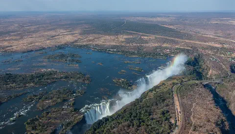
Victoria Falls, on the Zambezi River between Zambia and Zimbabwe, is about 1,708 meters wide and up to 108 meters deep. UNESCO calls it the largest curtain of falling water in the world, and its spray can be seen from tens of kilometers away.
-
 Watch
Landmark
Great Zimbabwe
Great Zimbabwe is the ruin of a great stone city in southern Africa, built by the Shona people between about 1100 and 1450. Its walls of granite blocks were laid without mortar. At its height it was the capital of a large state, with more than 10,000 people, and it traded gold for goods from as far away as China.
-
 Watch
City
Lilongwe
Lilongwe is the capital of Malawi, in southern Africa. It grew from a market village, and a new capital city was built next to it and opened in 1975. It lies on a high plateau about 1,100 meters above sea level, and Malawi's statistics office projected 1,162,500 people for it in 2023.
-
 Watch
Natural wonder
Okavango Delta
The Okavango Delta, in northwestern Botswana, is a huge wetland in the middle of a dry land. The Okavango River flows in from Angola, spreads out into channels, lagoons and grassy plains, and then soaks away into the sands of the Kalahari instead of reaching the sea. Its flood arrives in the dry season, drawing elephants, buffalo, zebras and many other animals.
-
 Watch
Natural wonder
Lake Malawi
Lake Malawi is one of the African Great Lakes, in the Great Rift Valley. UNESCO calls it one of the deepest lakes in the world, and it holds many hundreds of kinds of cichlid fish, nearly all found nowhere else.
-
 Watch
Landmark
Tsodilo
Tsodilo is a small group of rocky hills in the Kalahari Desert of Botswana. With more than 4,500 rock paintings in an area of only 10 square kilometers, it has been called the 'Louvre of the Desert'. People have used these hills for at least 100,000 years.
-
 Watch
Natural wonder
Lake Tanganyika
Lake Tanganyika lies in a deep crack in Africa called a rift valley. Britannica calls it the longest freshwater lake in the world, and only Lake Baikal, in Russia, is deeper. Four countries share it: Tanzania, the Democratic Republic of the Congo, Burundi and Zambia. Its water is home to about 250 kinds of cichlid fish found nowhere else.
Explore next
-
Watch
 Country
Zambia
Zambia is a landlocked country on a high plateau in south-central Africa, named after the Zambezi River. On its southern border the Zambezi thunders over Victoria Falls. About 22 million people live there, and its copper mines have long made it one of Africa's great copper producers.
-
 Watch
City
Nairobi
Nairobi, the capital of Kenya, sits high in the highlands of East Africa. It began in the late 1890s as a railway camp beside a Maasai water hole called Enkare Nairobi, "Cold Water." Today it is one of the biggest cities in tropical Africa, with Nairobi National Park, full of wild animals, at its edge.
-
 Watch
City
Windhoek
Windhoek is the capital of Namibia. It lies about 1,700 meters above the sea in a dry, hilly land. Namibia's 2023 census counted 486,186 people in Windhoek, about four times as many as in Rundu, the next-largest town.
-
 Watch
City
Kinshasa
Kinshasa is the capital and largest city of the Democratic Republic of the Congo. It stands on the south bank of the Congo River, about 515 kilometers from the Atlantic Ocean, facing the city of Brazzaville across the water. It grew from fishing and trading villages and was called Léopoldville until 1966.
-
 Watch
City
Maputo
Maputo is the capital of Mozambique, on a bay of the Indian Ocean in the far south of the country. Mozambique's statistics office projected 1,133,200 people in Maputo City in 2023. Until 1976 the city was called Lourenço Marques.
-
 Watch
City
Gaborone
Gaborone is the capital of Botswana, in southern Africa. It was built as a new capital in the 1960s, almost ready when Botswana became independent in 1966. Planned for 20,000 people, it counted 246,325 in the 2022 census.
-
Watch
City
Lilongwe
Lilongwe is the capital of Malawi, in southern Africa. It grew from a market village, and a new capital city was built next to it and opened in 1975. It lies on a high plateau about 1,100 meters above sea level, and Malawi's statistics office projected 1,162,500 people for it in 2023.
-
 Watch
City
Benoni
Benoni is a town in South Africa, near Johannesburg, in a region called the Witwatersrand. The encyclopedia Larousse names gold mines and electrical-machine making in Benoni. South Africa's 2011 census counted 158,777 people in the town.
For parents & teachers
What children will learn
- Locate Lusaka on Zambia's plateau in southern Africa.
- Explain what a planned city is and what its planners cared about.
- Read a rainfall table and find the rainy and dry seasons.
- Compare census counts from 1990 to 2022.
Recommended ages: 3 to 17 · About 15 minutes
Talk about it
- Lusaka was planned with many trees. Why might city planners want trees along streets?
- Zambia has no coast. How might a country with no sea send its goods abroad?
- Lusaka has months with almost no rain. How do people prepare for a long dry season?
Try at home or in class
- Rain chart: plot Lusaka's monthly rainfall and color the dry months.
- Plan a town: draw a new capital with a main road, public buildings, parks and an airport.
- Growth bars: draw bars for Lusaka's 1990, 2000, 2010 and 2022 census counts.
Key vocabulary: capital, landlocked, plateau, garden city, census, roundabout
Where these facts come from
- Wikidata , Wikimedia Foundation (CC0 1.0)
- Natural Earth vector data , Natural Earth (NACIS) (Public domain)
- Zambia: Provinces and Cities , City Population (Thomas Brinkhoff), from the Central Statistical Office / Zambia Statistics Agency
- Lusaka: The New Capital of Northern Rhodesia (Robert Home), synopsis , TU Delft, BK Books
- Zambie , Encyclopaedia Universalis
- Lusaka: climatological information , World Meteorological Organization, World Weather Information Service (Zambia)
- File:Downtown Lusaka.JPG (Matthew Grollnek, 8 December 2013) , Wikimedia Commons
- Wikimedia Commons , Wikimedia Foundation (Per file (public domain, CC0, CC BY or CC BY-SA); see each media record)
Checked, not yet human-reviewed. Last updated November 1, 2026. Spotted a mistake? Tell us.