
City Asia
Naypyidaw
Naypyidaw is the capital of Myanmar. It is a very new city. It was built in the 2000s, in the middle of the country.
Naypyidaw is the capital of Myanmar, in a wide basin in the center of the country. It is a new city: building work began in 2004 near the town of Pyinmana, and it was proclaimed the capital in March 2006. At the 2024 census, Naypyidaw, together with Pyinmana and Lewe, had 358,679 people.
Naypyidaw (Nay Pyi Taw), Myanmar's capital since March 2006, was built from 2004 on an isolated site near Pyinmana, about 320 km north of Yangon, as the country's new administrative center. The census count for the city with Pyinmana and Lewe was 333,506 in 2014 and 358,679 in 2024; it is linked to Yangon by road and by rail through Pyinmana station.
Photo: Hybernator, CC BY-SA 3.0, via Wikimedia Commons
Discover Naypyidaw
Naypyidaw is the capital of Myanmar. It is in the middle of the country.
It is a very new city. Builders started it in 2004.
Naypyidaw is the capital of Myanmar, Universalis says. It lies in the basin that stretches across the center of the country, about 320 kilometers north of Yangon. Its name, Nay Pyi Taw in Burmese, means 'abode of kings'.
At the 2024 census, 358,679 people lived in Naypyidaw together with the older towns of Pyinmana and Lewe. Ten years earlier, at the 2014 census, the same area had 333,506 people.
Myanmar Department of Population (via City Population): Naypyitaw including Pyinmana and Lewe 73,211 (census 1983, before the new city), 333,506 (census 29 March 2014), 358,679 (census 30 September 2024), third among Myanmar's cities in 2024 after Yangon and Mandalay. City Population warns that the reliability of the 2024 national figures is limited, because a large share of the country's population was estimated rather than counted.
Universalis: Naypyidaw (Burmese Nay Pyi Taw, 'abode of kings') lies in the basin of central Myanmar, in the south of the Mandalay division, and was built in the early 2000s as the country's new administrative center.
- Country
- Myanmar (capital since March 2006)
- People in Naypyidaw with Pyinmana and Lewe (census, 30 September 2024)
- 358,679
- Same area, census 29 March 2014
- 333,506
- Distance from Yangon
- about 320 km to the north
The Water Fountain Garden gate
Look at the tall, pointed arches! This is the gate to a garden with fountains.
The walls are blue and gold. Street lamps line the road.
This photo shows the entrance to the Water Fountain Garden, a park in Naypyidaw, on 5 December 2011. Three tall, pointed gray arches stand over the gate, the middle one much taller than the others. Below them, the gate walls are painted blue and gold, with the garden's name in English on the left and Burmese writing on the right.
A wide paved square lies in front, and a road lined with street lamps leads through the gate. Wikidata dates the garden from 2008.
Commons: 'Naypyidaw -- Water Fountain Garden', 5 December 2011, own work by the uploader Hybernator, CC BY-SA 3.0; description 'The Water Fountain Garden, Naypyidaw'.
In the picture: three pointed arches clad in gray panels, the central one far taller; gate walls with gold diamond patterns on blue, the name 'Naypyidaw Water Fountain Garden' in English on the left panel and Burmese text on the right; red-and-white curbs, a broad paved forecourt and a lamp-lined road through the central arch. Wikidata (inception, P571): the garden 2008; Naypyidaw Zoological Gardens 27 March 2008, about 19 km NE; Naypyidaw Safari Park 12 February 2011, about 19 km NE.
- Photo
- the Water Fountain Garden, Naypyidaw, 5 December 2011
- Naypyidaw Water Fountain Garden
- a park in Naypyidaw, dating from 2008 (Wikidata)
- Naypyidaw Zoological Gardens
- a zoo about 19 km northeast of the garden, dating from 2008 (Wikidata)
A capital built from scratch
Most cities grow slowly over hundreds of years. Naypyidaw was built all at once!
Builders started in 2004. In 2006 it became the capital.
Naypyidaw was built on purpose to be Myanmar's new center of government, Universalis says. Building work began in 2004 on an isolated site near the town of Pyinmana. Before that, Yangon was the capital.
Government offices began moving in 2005, first to Pyinmana, and Naypyidaw was proclaimed the capital in March 2006. At first the city had mostly government buildings, hotels, apartment blocks and an airport. Many government workers came, while their families often stayed in Yangon.
Universalis: Naypyidaw was built in the early 2000s to become the country's new administrative center. Construction began in 2004 on an isolated site near Pyinmana, about 320 km north of Yangon, then the capital. The administration began to move in 2005, first to Pyinmana and then to Naypyidaw, which was proclaimed the capital in March 2006.
The new city at first held only administrative buildings, luxury hotels, apartment buildings and an airport, and was home mainly to civil servants, whose families often stayed in Yangon because the new capital lacked shops, restaurants and other services.
- Building work began
- 2004, on an isolated site near Pyinmana
- Government offices began to move
- 2005, first to Pyinmana
- Proclaimed the capital
- March 2006
Roads, a railway station and an airport
You can come to Naypyidaw by road or by train. The trains stop in Pyinmana, a town nearby.
Naypyidaw is linked to Yangon by road and by railway, Universalis says. Trains use the station of Pyinmana, an older town about 9 kilometers east of the Water Fountain Garden, Wikidata shows.
Nay Pyi Taw International Airport lies about 16 kilometers south-southeast of the garden. Universalis also notes something unusual for Myanmar: the new city was given an electricity network that works without breaks.
Universalis: the city is linked to Yangon by road and by railway, thanks to the nearby Pyinmana station; despite its few facilities, it was given an uninterrupted electricity network, an exception in the country.
Wikidata (from the Water Fountain Garden, Q6983180): Pyinmana Railway Station 8.80 km E; Pyinmana 8.84 km E; Nay Pyi Taw International Airport (elevation 90 m) 16.33 km SSE; Naypyidaw Zoological Gardens 18.97 km NE; Naypyidaw Safari Park 19.44 km NE.
- To Yangon
- by road, and by rail through the nearby Pyinmana station
- Pyinmana Railway Station
- about 9 km east of the Water Fountain Garden (Wikidata)
- Nay Pyi Taw International Airport
- about 16 km south-southeast of the Water Fountain Garden, 90 m above sea level (Wikidata)
Hot, then very wet
In April, Naypyidaw is very hot. Then the rains come, from May to October.
From December to March, it is dry.
The World Meteorological Organization's normals for Naypyitaw (1981–2010) show hot, dry months before a long rainy season. April is the hottest month, with average daily highs of 37.6 °C. January is the coolest, with average daily lows of 14.1 °C.
About 1,190 millimeters of rain fall in a year, almost all from May to October. August is the wettest month, with about 257 millimeters, while January gets only about 2.
WMO World Weather Information Service, Naypyitaw (19.77° N, 96.18° E), normals 1981–2010: mean daily maximum from 29.9 °C (December) to 37.6 °C (April); mean daily minimum from 14.1 °C (January) to 24.5 °C (May). Rainfall sums to 1,188.8 mm; May to October bring 1,100.6 mm, with August the wettest month (256.5 mm) and January the driest (2.1 mm). The table gives no usable rain-day counts.
Neighboring WWIS stations differ as expected: Taungoo, to the south, gets 1,964.9 mm and Meiktila, to the north, 812.9 mm in a year.
- Hottest month, average daily high (WMO, 1981–2010)
- 37.6 °C (April)
- Coolest month, average daily low (same normals)
- 14.1 °C (January)
- Rain in a year (sum of the monthly normals)
- about 1,190 mm
Parks, a zoo and wide roads
Naypyidaw has a garden with fountains. It also has a zoo and a safari park!
Families can visit the animals there.
Naypyidaw has a park with fountains, the Water Fountain Garden, as well as a zoo, the Naypyidaw Zoological Gardens, and a wildlife park, the Naypyidaw Safari Park. Wikidata places the zoo and the safari park side by side, about 19 kilometers northeast of the garden.
In its first years, Universalis says, the new capital had few shops, restaurants and other services, which is why many families of government workers stayed in Yangon.
Wikidata: Naypyidaw Water Fountain Garden (Q6983180), a park in Naypyidaw, inception 2008; Naypyidaw Zoological Gardens (Q862533), a zoo, inception 27 March 2008; Naypyidaw Safari Park (Q861893), a wildlife park, inception 12 February 2011. The zoo and the safari park lie about 0.9 km apart.
Universalis: at first the city held only administrative buildings, luxury hotels, apartment buildings and an airport; civil servants' families often stayed in Yangon because the new capital lacked shops, restaurants and other services.
- Water Fountain Garden
- park (Wikidata)
- Naypyidaw Zoological Gardens
- zoo (Wikidata)
- Naypyidaw Safari Park
- wildlife park (Wikidata)
Naypyidaw on the map
Find Myanmar on the globe, in Southeast Asia. Naypyidaw is right in the middle of the country.
Naypyidaw lies at about 19.8° north, in the basin across the middle of Myanmar, about 320 kilometers north of Yangon.
Measured from the Water Fountain Garden, the older town of Pyinmana is about 9 kilometers east, the airport about 16 kilometers south-southeast, and the zoo about 19 kilometers northeast.
Naypyidaw lies at about 19.77° N and 96.12° E (Natural Earth point, 2.5 km NNW of the Water Fountain Garden). From the garden (Wikidata points): the city's Wikidata point 0.90 km W, Pyinmana 8.84 km E, Nay Pyi Taw International Airport 16.33 km SSE, Naypyidaw Zoological Gardens 18.97 km NE.
Universalis: in the basin that stretches across the center of Myanmar, in the south of the Mandalay division, about 320 km north of Yangon.
- Latitude
- about 19.8° north
- Longitude
- about 96.1° east
- Setting
- in the central basin of Myanmar, south of the Mandalay division
Amazing facts
-
Naypyidaw's name means 'home of kings'.
In Burmese, Nay Pyi Taw means 'abode of kings', Universalis says.
Universalis: Naypyidaw (in Burmese Nay Pyi Taw, 'abode of kings').
-
Naypyidaw went from building site to capital in just two years!
Building work on Naypyidaw began in 2004, and the city was proclaimed Myanmar's capital in March 2006, Universalis says.
Universalis: construction began in 2004 on an isolated site near Pyinmana; the administration moved from 2005, and Naypyidaw was proclaimed the capital in March 2006.
-
The electricity in Naypyidaw was built to stay on all the time.
Naypyidaw was given an electricity network that works without breaks, which Universalis calls an exception in Myanmar.
Universalis: despite its sparse facilities, the new city was given an uninterrupted electricity network, an exception in the country.
-
Naypyidaw has a zoo and a safari park, next to each other.
Naypyidaw Zoological Gardens and Naypyidaw Safari Park lie side by side, about 19 kilometers northeast of the Water Fountain Garden, Wikidata shows.
Wikidata: Naypyidaw Zoological Gardens (inception 27 March 2008) and Naypyidaw Safari Park (inception 12 February 2011), about 0.9 km apart.
Words to know
- capital
- the city where a country's government works
- planned city
- a city designed and built on purpose, instead of growing slowly
- administrative center
- a place where government offices do their work
- basin
- a wide, low area of land with higher land around it
- census
- an official count of all the people in a country
- rainy season
- the part of the year when most of the rain falls
Discovery challenge
-
Naypyidaw is the capital of which country?
Naypyidaw was proclaimed the capital of which country in 2006?
Since March 2006, Naypyidaw has been the capital of which country?
- Myanmar
- Chile
- Canada
Show the answer
Myanmar
Myanmar!
Myanmar.
Myanmar.
-
When did builders start making Naypyidaw?
In which year did building work on Naypyidaw begin?
Universalis says construction began on the isolated site near Pyinmana in which year?
- 2004
- 1904
- 1604
Show the answer
2004
2004, not long ago!
2004.
2004.
-
What does the name Nay Pyi Taw mean?
What does Nay Pyi Taw mean in Burmese?
Universalis translates the Burmese name Nay Pyi Taw as what?
- Abode of kings
- Land of rivers
- Green hill
Show the answer
Abode of kings
Home of kings!
Abode of kings.
'Abode of kings'.
-
Which nearby town has the train station?
Trains to Naypyidaw use the station of which nearby town?
Universalis says the rail link to Yangon runs through the station of which neighboring town?
- Pyinmana
- Mandalay
- Yangon
Show the answer
Pyinmana
Pyinmana!
Pyinmana.
Pyinmana.
-
Which month is the hottest in Naypyidaw?
In the WMO normals, which month has Naypyidaw's highest average daily high?
WMO normals (1981–2010): in which month does the mean daily maximum reach 37.6 °C?
- April
- August
- December
Show the answer
April
April!
April.
April (37.6 °C).
Nearby places
-
 Watch
City
Chiang Mai
Chiang Mai is the main city of northern Thailand, on the Ping River. The encyclopedia Larousse says it was founded in 1296 as the capital of the Thai kingdom of Lan Na. Thailand's registration counted 127,240 people in the city at the end of 2019.
-
 Watch
Landmark
Shwedagon Pagoda
The Shwedagon Pagoda is a huge Buddhist stupa covered in gold, on Singuttara Hill in the center of Yangon, Myanmar. Rebuilt and raised by kings and a queen over many centuries, it now stands 112 meters tall. Covered stairways climb the hill to it from the four directions.
-
 Watch
City
Yangon
Yangon, once spelled Rangoon, is the largest city in Myanmar and its main port. It lies in the eastern part of the Irrawaddy delta, where two rivers meet. At the 2024 census, 4,584,622 people lived in the city.
-
 Watch
City
Luang Prabang
Luang Prabang is a town in northern Laos, built on a peninsula where the Nam Khan River meets the Mekong. From the 14th to the 16th century it was the capital of the kingdom of Lane Xang, the 'Kingdom of a Million Elephants'. UNESCO lists the town as a World Heritage Site for the way it mixes traditional Lao buildings with buildings from colonial times.
-
 Watch
City
Vientiane
Vientiane is the capital of Laos, on the left bank of the Mekong River. Lao Statistics Bureau figures give Vientiane Capital, the prefecture around the city, an estimated 844,020 people in mid-2015.
-
 Watch
City
Dhaka
Dhaka is the capital and most populous city of Bangladesh, just north of the Buriganga River. The 2022 census counted about 10.3 million people in its two city corporations. Its painted cycle rickshaws are on UNESCO's list of the world's living heritage.
-
 Watch
Landmark
Ayutthaya Historical Park
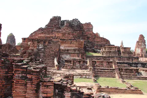
Ayutthaya, in Thailand, was founded in 1350 and became the second capital of the Siamese kingdom. From the 14th to the 18th centuries it grew into a center of trade and diplomacy. Today its brick ruins, tall towers and the remains of large monasteries are kept in a historical park, a UNESCO World Heritage Site since 1991.
-
 Watch
Natural wonder
Sundarbans
The Sundarbans is a vast mangrove forest where the Ganges and Brahmaputra rivers meet the Bay of Bengal. It is shared by Bangladesh and India. Twice a day the tides flood its muddy islands, and its trees are made to live in salty water. It is one of the last homes of the Bengal tiger, and both countries protect it as a World Heritage Site.
Explore next
-
Watch
 Country
Myanmar
Myanmar, also called Burma, is the northernmost country of Southeast Asia. Snowy mountains rise in the far north, and the long Irrawaddy River flows south through its heartland to a huge delta of rice fields. About 55 million people live there.
-
 Watch
City
Brasília
Brasília is the capital of Brazil, built from scratch on a high plateau in the middle of the country. It opened on April 21, 1960, with a plan by Lúcio Costa and buildings by Oscar Niemeyer. Brazil's statistics office estimated 2,996,899 people in 2025.
-
 Watch
City
Abuja
Abuja is the capital of Nigeria, in the middle of the country. It was planned from the start: in 1976 the government decided to build a new capital on the savanna, and in 1991 it moved there from Lagos. Planners set aside land for parks and green spaces, and the huge Aso Rock rises at the city's edge.
-
 Watch
City
Bangkok
Bangkok, the capital of Thailand, lies on the delta of the Chao Phraya River, about 40 kilometers from the sea. It became the capital in 1782, when the new royal palace and temples were built. Once called the 'Venice of the East' for its canals, it is now a huge, busy city with skyscrapers and an elevated railway.
-
Watch
City
Yangon
Yangon, once spelled Rangoon, is the largest city in Myanmar and its main port. It lies in the eastern part of the Irrawaddy delta, where two rivers meet. At the 2024 census, 4,584,622 people lived in the city.
-
 Watch
City
Abu Dhabi
Abu Dhabi is the capital of the United Arab Emirates. It began in the 1700s as a small settlement around fresh water on an island, guarded by a coral-stone watchtower. Before oil, it relied on fishing and pearl diving; since the 1960s, money from oil has turned it into a city of towers. An official estimate gave the city about 1.75 million people in 2023.
-
 Watch
City
Almaty
Almaty is the main city of Kazakhstan, in the southeast of the country at the foot of the Ala-Tau mountains. It was founded in 1854 where a Kazakh village called Almaty, 'village of apple trees', stood. It was the capital until 1998, and about 2,387,900 people lived there on 1 September 2026.
-
 Watch
City
Amman
Amman is the capital of Jordan, built on steep hills around a valley high on a plateau. Long ago it was a Roman city called Philadelphia, and its Roman theater, carved into a hillside, still holds about 6,000 people. Today the city spreads across the hills, with houses faced in pale stone. About 4.6 million people lived in Amman Governorate at the end of 2021.
For parents & teachers
What children will learn
- Locate Naypyidaw in the center of Myanmar.
- Explain what a planned capital is and how it differs from a city that grew slowly.
- Put the steps of building a new capital in order, from 2004 to 2006.
- Read a climate table and find the hot season and the rainy season.
Recommended ages: 3 to 17 · About 15 minutes
Talk about it
- What would a city need before people could move there to live and work?
- Why might families stay behind when a city has few shops and services?
- Naypyidaw is very hot in April and very wet in August. How might people get ready for each season?
Try at home or in class
- Plan a city: draw a map of a new town with offices, homes, a park, a station and roads.
- Rain chart: plot the twelve monthly rain totals and color the rainy months.
- Timeline strip: mark 2004, 2005 and 2006 on a paper strip and write what happened in each year.
Key vocabulary: capital, planned city, administrative center, basin, census, rainy season
Where these facts come from
- Wikidata , Wikimedia Foundation (CC0 1.0)
- Natural Earth vector data , Natural Earth (NACIS) (Public domain)
- Naypyidaw , Encyclopaedia Universalis
- Myanmar: Regions, States, Cities and Towns , City Population (Thomas Brinkhoff), from the Myanmar Department of Population
- Naypyitaw: climatological information , World Meteorological Organization, World Weather Information Service
- File:Naypyidaw -- Water Fountain Garden.JPG (Hybernator, 5 December 2011) , Wikimedia Commons
- Wikimedia Commons , Wikimedia Foundation (Per file (public domain, CC0, CC BY or CC BY-SA); see each media record)
Checked, not yet human-reviewed. Last updated November 1, 2026. Spotted a mistake? Tell us.