Landmark Asia
Ayutthaya Historical Park
Ayutthaya Historical Park is in Thailand. It keeps the brick ruins of an old capital city on an island between rivers.
Ayutthaya, in Thailand, was founded in 1350 and became the second capital of the Siamese kingdom. From the 14th to the 18th centuries it grew into a center of trade and diplomacy. Today its brick ruins, tall towers and the remains of large monasteries are kept in a historical park, a UNESCO World Heritage Site since 1991.
The Historic City of Ayutthaya, founded in 1350 as the second capital of the Siamese kingdom, flourished from the 14th to the 18th centuries and, in UNESCO's words, grew to be one of the world's largest and most cosmopolitan urban areas. Its brick-and-stucco ruins, with prang towers and monasteries of monumental proportions, were listed by UNESCO in 1991 for criterion (iii).
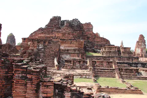
Photo: Gary Todd from Xinzheng, China, CC0 1.0, via Wikimedia Commons
Discover Ayutthaya
Ayutthaya is in Thailand, a country in Southeast Asia.
The old city stood on an island with three rivers around it.
Ayutthaya stands on an island surrounded by three rivers, which connect it to the sea. UNESCO says the place was chosen partly because it kept the city safe from warships coming in from the sea, and because it helped protect the city from seasonal floods.
Today the ruins are kept in a historical park. The World Heritage Site covers 289 hectares around the old Royal Palace.
UNESCO explains that Ayutthaya was strategically located on an island surrounded by three rivers connecting the city to the sea, above the tidal bore of the Gulf of Siam as it then was, which kept sea-going warships away; the location also helped protect it from seasonal flooding.
The World Heritage property covers 289 ha, confined to the former Royal Palace precinct and its immediate surroundings, in Phra Nakhon Si Ayutthaya Province. UNESCO notes that an extension to the whole of Ayutthaya Island is being prepared.
- Where
- Ayutthaya Province, Thailand
- Founded
- 1350
- Area
- 289 ha
- World Heritage Site
- 1991
A capital of trade
Ayutthaya became a capital city in the year 1350.
People came from many lands to trade there.
Ayutthaya was founded in 1350 and became the second capital of the Siamese kingdom, after Sukhothai. It grew from the 14th to the 18th centuries into a center of trade and diplomacy, and its royal court exchanged ambassadors with the courts of France, Japan and China and the Mughal court in Delhi.
The city was destroyed by the Burmese army in 1767 and was never rebuilt in the same place.
UNESCO and ICOMOS date the city's founding to 1350, when it became the second Siamese capital after Sukhothai. UNESCO describes it as one of the world's largest and most cosmopolitan urban areas and a center of global diplomacy and commerce; the Royal Court exchanged ambassadors with the French Court at Versailles, the Mughal Court in Delhi and the imperial courts of Japan and China, and foreign traders lived in their own districts.
The city was destroyed by the Burmese army in 1767 and never rebuilt on the same site. ICOMOS records that it was classed as a historical park in 1967.
A city of brick and canals
The buildings were made of brick and covered with smooth plaster.
The city had roads, canals and moats laid out in a careful pattern.
Ayutthaya was built of brick covered with stucco, a kind of plaster. ICOMOS says the decoration has now gone, leaving the bare brick open to the weather.
The city was laid out on a careful grid of roads, canals and moats around its main buildings. UNESCO calls its system for managing water technologically extremely advanced.
ICOMOS describes the site's characteristic architecture as brick and stucco, now devoid of its decoration and completely exposed to the elements. UNESCO says the ruins of the most important buildings have been consolidated, repaired and sometimes reconstructed.
Ayutthaya was laid out according to a systematic and rigid planning grid of roads, canals and moats around all the principal structures, and UNESCO calls its hydraulic system for water management technologically extremely advanced. Maps drawn by foreign emissaries of the time show the pattern, which is still visible across the island.
Prang towers and great monasteries
Ayutthaya has tall towers called prang.
There are also the ruins of very large monasteries.
The main architectural feature of the city was the prang, a kind of tall tower that ICOMOS says did not exist at Sukhothai, the earlier capital. The kings of Ayutthaya paid for monasteries that grew to a very large size, such as Wat Mahathat and Wat Si Sanphet.
The buildings were once decorated with crafts and wall paintings. Some paintings survive in the crypt of Wat Ratchaburana.
ICOMOS calls the prang the main architectural feature of the town, a tower form that did not exist at Sukhothai, and says the kings of Ayutthaya richly endowed monasteries that reached gigantic proportions: Wat Mahathat (14th-17th centuries) and Wat Si Sanphet (15th century), for example.
UNESCO describes the buildings as decorated with crafts and mural paintings mixing styles from Sukhothai, Angkor, Japan, China, India, Persia and Europe; surviving murals in the crypt of Wat Ratchaburana are of particular note. UNESCO lists the city for criterion (iii): excellent witness to the development of a true national Thai art.
- Wat Mahathat
- 14th–17th centuries
- Wat Si Sanphet
- 15th century
- Historical park
- 1967
- UNESCO criterion
- (iii)
Brick ruins in the sun
In this photo, piles of old red bricks rise up like steps and walls.
Green grass grows between the ruins.
This photo was taken on 1 December 2018. A large ruined brick building rises in the middle, with crumbling brick walls in front. Ruined towers stand at the left and right edges, and green lawns lie between the low brick platforms.
The ruins are bare brick today, without the plaster that once covered them.
The photograph (1 December 2018, by Gary Todd) shows red-brick ruins in Ayutthaya Historical Park: a large ruined brick mass at the center, crumbling walls and a leaning column in front, terraced brick platforms with lawns at the right, a weathered rounded tower at the left edge and a ruined pointed tower at the right. No source names the monastery shown.
UNESCO says the historic city is managed as a historical park and protected by Thai law, which the Fine Arts Department enforces, with a master plan approved by the Cabinet.
Amazing facts
-
When Bangkok was built, people tried to make it like Ayutthaya!
When a new capital was built at Bangkok, its builders tried on purpose to copy Ayutthaya's plan and buildings.
UNESCO says the builders of the new capital at Bangkok made a conscious attempt to recreate Ayutthaya's urban template and architecture, and many surviving Ayutthaya architects and builders worked on it.
-
Bangkok's long official name has the word Ayutthaya in it!
The official Thai name of Bangkok still includes the word 'Ayutthaya'.
In Thai, the official name of the capital at Bangkok retains 'Ayutthaya' as part of its formal title.
-
Visitors from far away drew maps of Ayutthaya!
Foreign visitors to the royal court drew maps of the city, and these maps show its streets and canals.
Maps prepared by foreign emissaries to the Royal Court record the city's elaborate but systematic pattern of streets and canals, which remains visible across the island.
Words to know
- capital
- the city where a country's government or ruler is based
- prang
- a kind of tall tower, the main feature of Ayutthaya's buildings
- stucco
- a kind of plaster spread over walls to make them smooth
- moat
- a ditch filled with water around a building or town
- monastery
- a group of buildings where monks live and study
- World Heritage Site
- a place UNESCO lists as important for all people
Discovery challenge
-
In which country is Ayutthaya?
Ayutthaya Historical Park is in which country?
Under which country's law is the Historic City of Ayutthaya protected as a historical park?
- Thailand
- Tunisia
- Turkmenistan
Show the answer
Thailand
Thailand!
Thailand.
Thailand.
-
In which year was Ayutthaya founded?
In which year did Ayutthaya become the second Siamese capital?
In which year do UNESCO and ICOMOS date the founding of Ayutthaya?
- 1350
- 1650
- 1950
Show the answer
1350
1350!
1350.
1350.
-
How many rivers flow around the island of Ayutthaya?
How many rivers surround the island that Ayutthaya stands on?
By how many rivers is Ayutthaya's island surrounded, connecting it to the sea?
- 3
- 1
- 10
Show the answer
3
3 rivers!
Three.
Three.
-
What is the tall tower of Ayutthaya called?
What is the name of the tall tower that ICOMOS calls the city's main architectural feature?
Which tower form, absent at Sukhothai, was the main architectural feature of Ayutthaya?
- Prang
- Pagoda
- Pylon
Show the answer
Prang
A prang!
The prang.
The prang.
-
What are the ruins of Ayutthaya mostly made of?
What were Ayutthaya's buildings made of?
Which materials does ICOMOS name for the site's characteristic architecture?
- Brick and stucco
- Wood and paper
- Steel and glass
Show the answer
Brick and stucco
Brick, covered with plaster!
Brick covered with stucco.
Brick and stucco.
Nearby places
-
 Watch
City
Bangkok
Bangkok, the capital of Thailand, lies on the delta of the Chao Phraya River, about 40 kilometers from the sea. It became the capital in 1782, when the new royal palace and temples were built. Once called the 'Venice of the East' for its canals, it is now a huge, busy city with skyscrapers and an elevated railway.
-
 Watch
Landmark
Angkor
Angkor, in northwestern Cambodia, was the capital of the Khmer Empire from the 9th to the 15th century. Its kings built city after city here, with scores of temples, such as Angkor Wat and the Bayon, and giant reservoirs and canals to water the rice fields. Today it covers about 400 square kilometers, and more than 100,000 people live in villages inside it.
-
Watch
Landmark
Angkor Wat
Angkor Wat, near the town of Siem Reap in Cambodia, was built in the 12th century by the Khmer king Suryavarman II. Britannica (2026) calls it the world's largest religious structure. It was built as a Hindu temple and later became a Buddhist place of worship.
-
 Watch
City
Vientiane
Vientiane is the capital of Laos, on the left bank of the Mekong River. Lao Statistics Bureau figures give Vientiane Capital, the prefecture around the city, an estimated 844,020 people in mid-2015.
-
 Watch
City
Chiang Mai
Chiang Mai is the main city of northern Thailand, on the Ping River. The encyclopedia Larousse says it was founded in 1296 as the capital of the Thai kingdom of Lan Na. Thailand's registration counted 127,240 people in the city at the end of 2019.
-
 Watch
City
Yangon
Yangon, once spelled Rangoon, is the largest city in Myanmar and its main port. It lies in the eastern part of the Irrawaddy delta, where two rivers meet. At the 2024 census, 4,584,622 people lived in the city.
-
 Watch
Landmark
Shwedagon Pagoda
The Shwedagon Pagoda is a huge Buddhist stupa covered in gold, on Singuttara Hill in the center of Yangon, Myanmar. Rebuilt and raised by kings and a queen over many centuries, it now stands 112 meters tall. Covered stairways climb the hill to it from the four directions.
-
 Watch
City
Luang Prabang
Luang Prabang is a town in northern Laos, built on a peninsula where the Nam Khan River meets the Mekong. From the 14th to the 16th century it was the capital of the kingdom of Lane Xang, the 'Kingdom of a Million Elephants'. UNESCO lists the town as a World Heritage Site for the way it mixes traditional Lao buildings with buildings from colonial times.
Explore next
-
Watch
 Country
Thailand
Thailand is a tropical country in the middle of mainland Southeast Asia, with forested mountains in the north, rice fields on its central plains and a long, narrow peninsula in the south. Its capital is Bangkok, and about 65.8 million people were on its civil register at the end of 2025.
-
Watch
City
Bangkok
Bangkok, the capital of Thailand, lies on the delta of the Chao Phraya River, about 40 kilometers from the sea. It became the capital in 1782, when the new royal palace and temples were built. Once called the 'Venice of the East' for its canals, it is now a huge, busy city with skyscrapers and an elevated railway.
-
Watch
Landmark
Angkor
Angkor, in northwestern Cambodia, was the capital of the Khmer Empire from the 9th to the 15th century. Its kings built city after city here, with scores of temples, such as Angkor Wat and the Bayon, and giant reservoirs and canals to water the rice fields. Today it covers about 400 square kilometers, and more than 100,000 people live in villages inside it.
-
 Watch
Landmark
Abraj Al Bait
Abraj Al Bait is a group of seven hotel towers in Mecca, Saudi Arabia, beside the city's Great Mosque. In the middle rises the Makkah Royal Clock Tower, 601 meters tall to the tip of its spire, with a huge clock near the top. It was finished in 2012.
-
 Watch
Landmark
Agra Fort
Agra Fort is a huge red sandstone fortress beside the Yamuna River in Agra, India. The Mughal emperor Akbar began it in 1565. Its walls, about 2.5 kilometers around, protect palaces, halls and mosques added by later emperors. It was both an army base and a royal home.
-
 Watch
Landmark
Akashi Kaikyō Bridge
The Akashi Kaikyō Bridge is a suspension bridge almost 4 kilometers long that crosses the Akashi Strait between Kobe and Awaji Island in Japan. Its middle span is 1,991 meters. When it opened in 1998, it was the longest suspension bridge in the world.
-
 Watch
Landmark
Al Zubarah
Al Zubarah is the ruin of a walled town on the coast of Qatar. For about 50 years, in the late 1700s and early 1800s, it was a busy center for pearls and trade. After it was abandoned, desert sand covered and protected its houses, palaces and streets. It became a UNESCO World Heritage Site in 2013.
-
 Watch
Landmark
Al-Aqsa Mosque
Al-Aqsa Mosque stands at the southern end of a huge raised plaza in the Old City of Jerusalem. Built in the early 700s, it has a silver-gray dome, and the golden Dome of the Rock stands nearby. The plaza is important to Muslims and to Jews.
For parents & teachers
What children will learn
- Explain why a city might be built on an island between rivers.
- Describe how canals and moats can shape the plan of a city.
- Explain how trade and visitors can bring new ideas to a place.
Recommended ages: 4 to 17 · About 15 minutes
Talk about it
- Why might rivers both help and protect a city?
- Why would people building a new capital copy an old one?
- How can we learn about a city from old maps drawn by visitors?
Try at home or in class
- Draw a city on an island with three rivers around it, then add a grid of canals and roads.
- Find Ayutthaya, Bangkok and the Gulf of Thailand on a map.
Key vocabulary: capital, prang, stucco, moat, monastery, World Heritage Site
Where these facts come from
- Wikidata , Wikimedia Foundation (CC0 1.0)
- Historic City of Ayutthaya , UNESCO World Heritage Centre
- Advisory Body Evaluation: The Historic City of Ayutthaya, No 576 , ICOMOS / UNESCO World Heritage Centre
- File:Ayutthaya Historical Park (44638637840).jpg , Wikimedia Commons
- UNESCO World Heritage List , UNESCO World Heritage Centre (Linked as a reference; site facts come from Wikidata)
- Wikimedia Commons , Wikimedia Foundation (Per file (public domain, CC0, CC BY or CC BY-SA); see each media record)
Checked, not yet human-reviewed. Last updated November 1, 2026. Spotted a mistake? Tell us.