
City Asia
Chiang Mai
Chiang Mai is a city in the north of Thailand. A big green mountain rises behind it!
Chiang Mai is the main city of northern Thailand, on the Ping River. The encyclopedia Larousse says it was founded in 1296 as the capital of the Thai kingdom of Lan Na. Thailand's registration counted 127,240 people in the city at the end of 2019.
Chiang Mai, a provincial capital on the Me Ping founded in 1296 as the capital of the Lan Na kingdom and today the main city of northern Thailand (Larousse), had a registered population of 127,240 in its city municipality on 31 December 2019 (City Population, from the Bureau of Registration Administration); Larousse gives 167,776 at the 2000 census.
Photo: Blowing Puffer Fish, CC BY 2.0, via Wikimedia Commons
Discover Chiang Mai
Chiang Mai is a city in Thailand, a country in Southeast Asia.
It is the main city in the north of the country.
Chiang Mai is a city in the north of Thailand, on the Ping River. The French encyclopedia Larousse calls it the main city of northern Thailand and the main town of its province, linked to Bangkok by railway.
Thailand counts people through its registration offices. At the end of 2019, 127,240 people were registered in the city municipality of Chiang Mai.
Larousse ('Chiangmai ou Chiengmai'): a town of Thailand, chef-lieu (main town) of a province, on the Me Ping; population 167,776 (2000 census); founded in 1296, capital of the Thai kingdom of Lan Na; today linked to Bangkok by railway, the main town of northern Thailand; timber trade, handicrafts. City Population (from the Bureau of Registration Administration), 'Chiang Mai', City (municipality, 40.00 km² as listed): registered population 151,011 (31 December 2005), 141,361 (2010), 132,556 (2015), 127,240 (31 December 2019); eighth in its 2019 list of Thai municipalities.
- Country
- Thailand: the main city of the north, on the Me Ping (Ping River) (Larousse)
- People in the city (registered, 31 December 2019)
- 127,240 (Chiang Mai city municipality)
- Founded
- 1296, as the capital of the Lan Na kingdom (Larousse)
- Known for
- the timber trade and handicrafts (Larousse)
Roofs below the mountain
Look at all the colorful roofs: red, orange, blue and white!
A long green mountain rises behind the city, under big white clouds.
Blowing Puffer Fish took this photo of Chiang Mai from high above on 26 July 2017. It shows a wide spread of red, orange, blue and white roofs among trees, some taller buildings, and a long, dark green, forested mountain behind the city under a deep blue sky with big white clouds.
On Wikidata, Tha Phae Gate, a gate, is about 1.1 kilometers east of the city's point, and Warorot Market about 1.8 kilometers east.
Commons: 'Chiang Mai and Doi Suthep Mountain 2017', a Flickr photo by Blowing Puffer Fish (CC BY 2.0, FlickreviewR 2 passed March 2025), dated 26 July 2017; camera point 18.7850° N, 98.9993° E, 1.74 km ESE of the city's Wikidata point. The file was first uploaded naming a different mountain and was renamed in May 2025 after another user's correction, so the mountain is not named here. The photo shows dense low and mid-rise buildings with colorful roofs, trees, a few towers and a forested ridge. A 2017 photo: it shows the city as it was then. Wikidata, from the city point (Q52028): Tha Phae Gate (Q13016585), a gate, 1.05 km E; Warorot Market (Q20558642), a market, 1.83 km E.
- In the photo
- Chiang Mai from high above, 26 July 2017 (Blowing Puffer Fish)
- Tha Phae Gate
- a gate about 1.1 km east of the city's point (Wikidata)
- Warorot Market
- a market about 1.8 km east of the city's point (Wikidata)
A kingdom's capital
Chiang Mai is very old. It was started in 1296!
It was the capital of a kingdom called Lan Na.
Larousse says Chiang Mai was founded in 1296 as the capital of Lan Na, a Thai kingdom. That is more than 700 years ago.
Today it is linked to Bangkok by railway. The registered population of the city municipality went from 151,011 at the end of 2005 to 127,240 at the end of 2019.
Larousse: 'Fondée en 1296, capitale du royaume thaï du Lan Na'; chronology: '1296 Création du royaume thaï de Lan Na avec Chiangmai pour capitale.' (Wikidata gives the 13th century.) City Population, registered population of the city municipality: 2005 151,011; 2010 141,361; 2015 132,556; 2019 127,240. Larousse: 167,776 (2000 census). Registration figures and census figures are counted differently and are not compared here.
- 1296
- the Thai kingdom of Lan Na is created with Chiang Mai as its capital (Larousse)
- 2000 census
- 167,776 people (Larousse)
- Registered, 2005 and 2019
- 151,011 and 127,240 people (City Population)
Gate, market and bridge
Trains run from Chiang Mai all the way to Bangkok.
The city sits on the Ping River.
Larousse places Chiang Mai on the Me Ping, the Ping River, and says a railway links it to Bangkok.
On Wikidata, Tha Phae Gate is about 1.1 kilometers east of the city's point, Warorot Market about 1.8 kilometers east and the Nawarat Bridge about 2.2 kilometers east.
Larousse: sur le Me Ping; reliée à Bangkok par voie ferrée. Wikidata from the city point (Q52028): Tha Phae Gate (Q13016585), a gate, 1.05 km E; Warorot Market (Q20558642), a market, 1.83 km E; Nawarat Bridge (Q13022440), a bridge, 2.23 km E.
- Railway
- linked to Bangkok by railway (Larousse)
- Nawarat Bridge
- a bridge about 2.2 km east of the city's point (Wikidata)
- River
- the Me Ping, or Ping River (Larousse)
A dry season and a rainy season
Chiang Mai is warm all year, and hottest in April.
From May to October it rains a lot. The rest of the year is much drier.
The Japan Meteorological Agency's averages for Chiang Mai, for 1991 to 2020, show the warmest month is April, at 29.6 °C on average, and the coolest January, at 22.3 °C.
About 1,112 millimeters of rain fall in a year, and almost nine-tenths of it falls from May to October. August is the wettest month, with 216.0 millimeters, while February and December get only about 10 millimeters each.
Japan Meteorological Agency, world climate normals (period 1991-2020, stated on the normals index page), station Chiang Mai, 18.77° N 98.97° E, 313 m: monthly mean temperature 22.3, 24.4, 27.4, 29.6, 28.8, 28.2, 27.7, 27.2, 27.2, 26.6, 24.7, 22.5 °C; precipitation 11.3, 10.3, 15.0, 54.8, 164.5, 126.8, 143.0, 216.0, 207.1, 123.8, 29.8, 10.0 mm (Jan-Dec); sum 1,112.4 mm; May-October 981.2 mm (88%). Check: the World Meteorological Organization's table for Chiang Mai (Thai Meteorological Department; no averaging period stated) sums to 1,126.2 mm, within about 1%.
- April, average temperature (JMA, Chiang Mai, 1991–2020)
- 29.6 °C, the warmest month
- Wettest and driest months (same table)
- August, 216.0 mm; February and December, about 10 mm
- Rain in a year (twelve months added up)
- about 1,112 mm
Timber and handicrafts
People in Chiang Mai make things by hand.
Wood is traded here too.
Larousse names two activities for Chiang Mai: the timber trade and handicrafts, things people make by hand.
Wikidata lists Warorot Market as a market in Chiang Mai, about 1.8 kilometers east of the city's point. The photo shows how the city's low buildings and colorful roofs spread out below the forested mountain.
Larousse: commerce du bois, artisanat. Larousse also notes many monuments in the style of northern Thai art (13th-20th centuries), inside and outside the walls. Wikidata: Warorot Market (Q20558642), a market in Chiang Mai City.
- Trade
- timber (Larousse)
- Crafts
- handicrafts (Larousse)
- Market
- Warorot Market (Wikidata)
Chiang Mai on the map
Find Thailand on the globe, then look to its north. Chiang Mai is there.
Chiang Mai lies at about 18.79° north and 98.98° east, in northern Thailand, on the Ping River.
On Wikidata, Tha Phae Gate is about 1.1 kilometers east of the city's point, Warorot Market about 1.8 kilometers east and the Nawarat Bridge about 2.2 kilometers east.
Chiang Mai lies at about 18.79° N, 98.98° E (Wikidata point of Chiang Mai, Q52028; the sheet point is 1.28 km NNW of it). Wikidata from the city point: Tha Phae Gate 1.05 km E; Warorot Market 1.83 km E; Nawarat Bridge 2.23 km E. The JMA station is 2.53 km SW.
- Latitude
- about 18.79° north
- Longitude
- about 98.98° east
- Region
- northern Thailand, on the Me Ping (Larousse)
Amazing facts
-
Chiang Mai was the capital of a kingdom called Lan Na!
Larousse says the Thai kingdom of Lan Na was created in 1296 with Chiang Mai as its capital.
Larousse chronology: '1296 Création du royaume thaï de Lan Na avec Chiangmai pour capitale.'
-
In Chiang Mai, almost all the rain falls between May and October!
In the Japan Meteorological Agency's averages for 1991 to 2020, May to October bring 981.2 of Chiang Mai's 1,112.4 millimeters of rain a year: almost nine-tenths.
JMA 1991–2020: May-October 164.5 + 126.8 + 143.0 + 216.0 + 207.1 + 123.8 = 981.2 mm of 1,112.4 mm (88%).
-
A train line links Chiang Mai to Bangkok!
Larousse says Chiang Mai is linked to Bangkok by railway.
Larousse: 'Aujourd'hui reliée à Bangkok par voie ferrée, c'est la principale ville du nord de la Thaïlande.'
Words to know
- kingdom
- a land ruled by a king or queen
- handicrafts
- things people make by hand, such as baskets, pots or carvings
- timber
- wood cut from trees for building and making things
- registered population
- the number of people written in a government's records as living in a place
- municipality
- a town or city with its own local government
- rainy season
- the part of the year when most of the rain falls
Discovery challenge
-
Chiang Mai is a city in which country?
In which country is the city of Chiang Mai?
Chiang Mai is the main city of the north of which country, according to Larousse?
- Thailand
- Mexico
- Norway
Show the answer
Thailand
Thailand!
Thailand.
Thailand.
-
In which year was Chiang Mai started?
According to Larousse, in which year was Chiang Mai founded?
In which year does Larousse date the founding of Chiang Mai as Lan Na's capital?
- 1296
- 1896
- 1996
Show the answer
1296
1296!
1296.
1296.
-
Which month brings the most rain to Chiang Mai?
In the 1991–2020 averages, which is Chiang Mai's wettest month?
Which month has the highest mean precipitation in JMA's 1991–2020 normals for Chiang Mai?
- August
- February
- December
Show the answer
August
August!
August, with 216.0 millimeters.
August, 216.0 mm.
-
Which river flows past Chiang Mai?
On which river does Larousse place Chiang Mai?
Larousse places Chiang Mai on which river?
- The Ping River
- The Amazon
- The Rhine
Show the answer
The Ping River
The Ping River!
The Ping River (Me Ping).
The Me Ping.
Nearby places
-
 Watch
City
Naypyidaw
Naypyidaw is the capital of Myanmar, in a wide basin in the center of the country. It is a new city: building work began in 2004 near the town of Pyinmana, and it was proclaimed the capital in March 2006. At the 2024 census, Naypyidaw, together with Pyinmana and Lewe, had 358,679 people.
-
 Watch
City
Luang Prabang
Luang Prabang is a town in northern Laos, built on a peninsula where the Nam Khan River meets the Mekong. From the 14th to the 16th century it was the capital of the kingdom of Lane Xang, the 'Kingdom of a Million Elephants'. UNESCO lists the town as a World Heritage Site for the way it mixes traditional Lao buildings with buildings from colonial times.
-
 Watch
City
Yangon
Yangon, once spelled Rangoon, is the largest city in Myanmar and its main port. It lies in the eastern part of the Irrawaddy delta, where two rivers meet. At the 2024 census, 4,584,622 people lived in the city.
-
 Watch
Landmark
Shwedagon Pagoda
The Shwedagon Pagoda is a huge Buddhist stupa covered in gold, on Singuttara Hill in the center of Yangon, Myanmar. Rebuilt and raised by kings and a queen over many centuries, it now stands 112 meters tall. Covered stairways climb the hill to it from the four directions.
-
 Watch
City
Vientiane
Vientiane is the capital of Laos, on the left bank of the Mekong River. Lao Statistics Bureau figures give Vientiane Capital, the prefecture around the city, an estimated 844,020 people in mid-2015.
-
 Watch
Landmark
Ayutthaya Historical Park
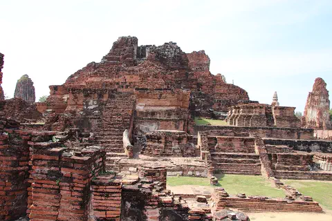
Ayutthaya, in Thailand, was founded in 1350 and became the second capital of the Siamese kingdom. From the 14th to the 18th centuries it grew into a center of trade and diplomacy. Today its brick ruins, tall towers and the remains of large monasteries are kept in a historical park, a UNESCO World Heritage Site since 1991.
-
 Watch
City
Bangkok
Bangkok, the capital of Thailand, lies on the delta of the Chao Phraya River, about 40 kilometers from the sea. It became the capital in 1782, when the new royal palace and temples were built. Once called the 'Venice of the East' for its canals, it is now a huge, busy city with skyscrapers and an elevated railway.
-
 Watch
Landmark
Imperial Citadel of Thang Long
The Imperial Citadel of Thang Long is in the heart of Hanoi, the capital of Vietnam. It was built in the 11th century by the Ly dynasty, on the remains of a 7th-century fortress. For almost 13 centuries it was a center of power. Its gates, old palace foundations and an archaeological site are a UNESCO World Heritage Site.
Explore next
-
Watch
 Country
Thailand
Thailand is a tropical country in the middle of mainland Southeast Asia, with forested mountains in the north, rice fields on its central plains and a long, narrow peninsula in the south. Its capital is Bangkok, and about 65.8 million people were on its civil register at the end of 2025.
-
Watch
City
Bangkok
Bangkok, the capital of Thailand, lies on the delta of the Chao Phraya River, about 40 kilometers from the sea. It became the capital in 1782, when the new royal palace and temples were built. Once called the 'Venice of the East' for its canals, it is now a huge, busy city with skyscrapers and an elevated railway.
-
 Watch
City
Kathmandu
Kathmandu is the capital of Nepal, in a valley in the foothills of the Himalayas, about 1,350 meters above sea level. Its old squares, palaces, temples and stupas are part of a UNESCO World Heritage Site. The 2021 census counted 862,400 people in the city.
-
 Watch
City
Abu Dhabi
Abu Dhabi is the capital of the United Arab Emirates. It began in the 1700s as a small settlement around fresh water on an island, guarded by a coral-stone watchtower. Before oil, it relied on fishing and pearl diving; since the 1960s, money from oil has turned it into a city of towers. An official estimate gave the city about 1.75 million people in 2023.
-
 Watch
City
Almaty
Almaty is the main city of Kazakhstan, in the southeast of the country at the foot of the Ala-Tau mountains. It was founded in 1854 where a Kazakh village called Almaty, 'village of apple trees', stood. It was the capital until 1998, and about 2,387,900 people lived there on 1 September 2026.
-
 Watch
City
Amman
Amman is the capital of Jordan, built on steep hills around a valley high on a plateau. Long ago it was a Roman city called Philadelphia, and its Roman theater, carved into a hillside, still holds about 6,000 people. Today the city spreads across the hills, with houses faced in pale stone. About 4.6 million people lived in Amman Governorate at the end of 2021.
-
 Watch
City
Ankara
Ankara is the capital of Türkiye, in the interior of Anatolia, about 200 kilometers from the Black Sea. People have lived here since the Stone Age, and Romans, Byzantines, Seljuks and Ottomans all left buildings behind. It became the capital in 1923, and today it is a city of government, universities and museums.
-
 Watch
City
Ashgabat
Ashgabat is the capital of Turkmenistan, in Central Asia. It lies at the foot of the Kopet Dag mountains, with the Karakum Desert to the north. The 2022 census counted 1,030,063 people, and Guinness World Records lists the city for its many white marble buildings.
For parents & teachers
What children will learn
- Locate Chiang Mai in northern Thailand, on the Ping River.
- Place the founding of Chiang Mai (1296) on a timeline.
- Read a climate table with a dry season and a rainy season.
- Tell the difference between a census count and a registered population.
Recommended ages: 3 to 17 · About 15 minutes
Talk about it
- Why might a kingdom choose a river valley below mountains for its capital?
- How would life change if almost all the year's rain fell in six months?
- Why might a city's registered population go down over 15 years?
Try at home or in class
- Rain bars: draw twelve bars for Chiang Mai's monthly rain and color May to October.
- Time line: mark 1296 and this year on a strip and count the centuries between them.
- Handicraft: make a small object by hand, such as a woven paper mat, and talk about how crafts are traded.
Key vocabulary: kingdom, handicrafts, timber, registered population, municipality, rainy season
Where these facts come from
- Wikidata , Wikimedia Foundation (CC0 1.0)
- Natural Earth vector data , Natural Earth (NACIS) (Public domain)
- Chiangmai ou Chiengmai , Larousse encyclopédie
- Thailand: Major Cities, Towns & Communes , City Population (Thomas Brinkhoff), from the Bureau of Registration Administration
- Climate normals: Chiang Mai (station 48327) , Japan Meteorological Agency
- World normals by region and country (normals period 1991-2020) , Japan Meteorological Agency
- Chiang Mai: climatological information , World Meteorological Organization, World Weather Information Service
- Chiang Mai and Doi Suthep Mountain 2017 , Wikimedia Commons
- Wikimedia Commons , Wikimedia Foundation (Per file (public domain, CC0, CC BY or CC BY-SA); see each media record)
Checked, not yet human-reviewed. Last updated November 1, 2026. Spotted a mistake? Tell us.