
City Asia
Yangon
Yangon is the biggest city in Myanmar. Two rivers meet there, and it has lots of rain in summer.
Yangon, once spelled Rangoon, is the largest city in Myanmar and its main port. It lies in the eastern part of the Irrawaddy delta, where two rivers meet. At the 2024 census, 4,584,622 people lived in the city.
Yangon (Rangoon), Myanmar's former capital and largest city, lies in the eastern Irrawaddy delta where the Hlaing (Yangon) and Pazundaung rivers meet. Universalis dates its real founding as a town to 1755; British rule built its port and gridded colonial center. Census 30 September 2024: 4,584,622 (reliability limited).
Photo: Photo: Marcin Konsek, CC BY-SA 4.0, via Wikimedia Commons
Discover Yangon
Yangon is the largest city in Myanmar, a country in Asia. Two rivers meet there.
Ships come to its port to load and unload.
Yangon is Myanmar's first city, Universalis says, in the eastern part of the Irrawaddy delta, where the Hlaing River (also called the Yangon River) meets the Pazundaung. Until 1989 its name was usually written Rangoon.
At the census of September 2024, 4,584,622 people were counted in the city. Yangon was the capital until March 2006, when the new city of Naypyidaw, about 300 kilometers to the north, took its place.
Universalis: former capital and first city of Myanmar (Burma), 4.8 million inhabitants at the 2014 census, in the eastern part of the Irrawaddy delta at the confluence of the Hlaing (or Rangoon River) and the Pazundaung; spelled Rangoun or Rangoon until 1989, then Yangôn; since March 2006 no longer the official capital, replaced by the new city of Naypyidaw, 300 km to the north.
Myanmar Department of Population (via City Population), city of Yangon: 2,472,176 (1983), 4,728,524 (2014), 4,584,622 (census 30 September 2024), rank 1; Yangon Region 7,369,989 (2024). City Population notes that part of the 2024 national total is estimated, so the reliability of the 2024 figures is limited.
- Country
- Myanmar (its largest city; capital until March 2006)
- People in Yangon (census, 30 September 2024)
- 4,584,622
- People at the 2014 census
- 4,728,524
- Rivers
- the Hlaing (or Yangon River) and the Pazundaung meet here
A red building with a clock tower
Look at the big red building with a clock high up in its tower! In front is a green lawn with round, trimmed bushes.
This photo shows the former High Court Building in Yangon on 17 November 2016. It is red with cream stripes and trim, and a tall clock tower with a dome rises from its middle.
In front is a lawn with neatly clipped bushes, where some workers are tending the grass. Beyond the railings, colorful umbrellas and tents line the street.
Commons: own work by Marcin Konsek (Halavar), 17 November 2016, CC BY-SA 4.0, a Commons Quality Image; description: 'The former High Court Building. Yangon, Myanmar.' The recorded position is about 2.4 km south of the city's Wikidata point.
In the picture: a red-and-cream building with red roofs, rows of arched windows and a domed clock tower; a lawn with clipped bushes and a paved path in front; a few workers on the grass, some under umbrellas; stalls with colorful umbrellas and tents, buses and cars along the street. Wikidata dates the High Court Building (Q20991961) to 1911.
- Photo
- the former High Court Building, 17 November 2016
- High Court Building
- dated to 1911 on Wikidata; about 2.4 km south of the city's Wikidata point
- Colonial center
- a grid of streets built between the old city and the port
From a hilltop pagoda to a port city
Long ago, Yangon grew up around a hill with a pagoda that has a gold dome. Later a modern port was built there.
Yangon grew up around a hill where the Shwedagon Pagoda stands, Universalis says; with its gold dome it is the city's most remarkable monument. The real town began in 1755, when it became the political center of Lower Burma.
Under British rule, Yangon got a modern port and a new town with a grid of straight streets, built between the old city and the port, for trade and government offices.
Universalis: the site grew around a hill where the Shwedagon Pagoda was built, which with its famous gold dome remains the city's most remarkable monument; the true urban creation dates only from 1755, when a Burmese king made it the political center of Lower Burma. British colonization gave Yangon its decisive growth: modern port facilities, a colonial-style town on a grid plan, with commercial and administrative functions, built between the old city and the port, and residential districts spreading to the north and northwest.
- Real founding as a town
- 1755
- Shwedagon Pagoda
- on a hill, with its gold dome: the city's most remarkable monument (Universalis)
- Colonial era
- a modern port and a grid-plan town built under British rule
A port, rivers and a circle line
Ships load and unload in Yangon's port. A train goes around the city in a big loop.
Yangon is Myanmar's first port, Universalis says, handling 90 percent of the country's exports and imports. It is also a great center of trade and government offices.
Since March 2006 the capital has been Naypyidaw, about 300 kilometers to the north. In Yangon itself, a commuter train line called the Yangon Circular Railway runs around the city; Wikidata dates it to 1954.
Universalis: a great administrative and commercial center and the first port of Burma (90% of the country's exports and imports); traditional industries linked to the port (rice mills, oil mills, timber).
Wikidata: Yangon Circular Railway (Q8048613), a commuter rail network, 1954 (P571 and P1619 both give the year only).
- Port
- Myanmar's first port, handling 90% of its exports and imports (Universalis)
- Yangon Circular Railway
- a commuter rail network, dated to 1954 on Wikidata
- Naypyidaw
- the capital since 2006, about 300 km to the north
A dry season and a very wet monsoon
Yangon is hot all year. From May to October it rains a lot, and in winter it hardly rains at all.
The World Meteorological Organization's averages for 1961 to 1990 show that April is Yangon's hottest month, with an average daily high of 37.0 °C. The coolest time is January, with an average low of 17.9 °C.
About 2,681 millimeters of rain fall in a year, almost all from May to October. August is the wettest month, with 602 millimeters, and February the driest, with just 2.
WMO World Weather Information Service, Yangon (16.77° N, 96.17° E), 1961–1990: mean daily maximum 29.6 °C (August) to 37.0 °C (April); mean daily minimum 17.9 °C (January) to 25.0 °C (May). Rainfall sums to 2,681 mm; May to October bring 2,585 mm, with August (602 mm) the wettest month and February (2 mm) the driest. June to August average more than 25 rain days each.
- Average daily highs (WMO, Yangon, 1961–1990)
- 29.6 °C (August) to 37.0 °C (April)
- Average daily lows (same normals)
- 17.9 °C (January) to 25.0 °C (May)
- Rain in a year (sum of the monthly normals)
- about 2,681 mm
Rice mills, cotton and trade
In Yangon there are rice mills and mills that make oil. Other factories spin cotton.
Yangon is a big center for trade and offices, Universalis says. Its oldest industries are linked to the port: rice mills, oil mills and timber. From the 1950s, factories spinning cotton, making medicines and making steel were added, along with an oil refinery.
In the city there are lakes too, such as Kandawgyi Lake, about 0.7 kilometers east of the city's center point on Wikidata.
Universalis: industrial activity grew especially from the 1950s: to the traditional food (rice mills, oil mills) and timber industries were added textiles (cotton spinning), a pharmaceutical industry, an electric steelworks and a refinery fed by pipeline from the oil fields of the Irrawaddy valley.
Wikidata: Kandawgyi Lake (Q385991) 0.70 km E and Inya Lake (Q864297) 4.90 km NNW of the city point.
- Old industries
- rice mills, oil mills and timber, linked to the port
- Since the 1950s
- cotton spinning, medicines, an electric steelworks and a refinery
- Kandawgyi Lake
- about 0.7 km east of the city's Wikidata point (Wikidata)
Yangon on the map
Find Myanmar on the globe, in Asia. Yangon is in the south, in a wide river delta.
Yangon lies at about 16.8° north, in the eastern part of the Irrawaddy delta in southern Myanmar.
Measured from the city's center point on Wikidata, Kandawgyi Lake is about 0.7 kilometers east, the Shwedagon Pagoda about 1.2 kilometers west-northwest, the High Court Building about 2.4 kilometers south and Inya Lake about 4.9 kilometers north-northwest.
Yangon lies at about 16.79° N and 96.16° E (Natural Earth point, 1.19 km SSE of the Wikidata point). From the Wikidata point (Q37995): Kandawgyi Lake 0.70 km E; Shwedagon Pagoda (Q464535) 1.18 km WNW; High Court Building (Q20991961) 2.43 km S; Inya Lake 4.90 km NNW. The WMO station point is 2.98 km SSE of the Wikidata point.
- Latitude
- about 16.8° north
- Longitude
- about 96.2° east
- Delta
- the eastern part of the Irrawaddy delta
Amazing facts
-
In February it hardly ever rains in Yangon.
In the WMO averages for 1961 to 1990, February brings only 2 millimeters of rain, but August brings 602.
WMO 1961–1990, Yangon: February 2 mm and 0.2 rain days; August 602 mm and 26.1 rain days.
-
Most of the things Myanmar sends to other countries go through Yangon's port.
Yangon's port handles 90 percent of Myanmar's exports and imports, Universalis says.
Universalis: Yangon is the first port of Burma, with 90% of the country's exports and imports.
-
Yangon's name used to be written Rangoon.
Until 1989 the city's name was usually written Rangoon; since then it has been written Yangon, closer to how it is said in Burmese, Universalis says.
Universalis: spelled Rangoun or Rangoon until 1989, then Yangôn, a transcription closer to the spoken Burmese pronunciation.
-
Yangon's old center has streets in a grid, like a checkerboard.
Under British rule, a new town with a grid of streets was built between the old city and the port, Universalis says.
Universalis: the colonial-style town on a grid plan, with commercial and administrative functions, was built between the old city and the port.
Words to know
- delta
- flat land where a river splits into many channels before it reaches the sea
- port
- a town or place where ships load and unload
- monsoon
- a season of strong winds that brings heavy rain
- pagoda
- a tower-shaped building found in many Asian countries
- colonial
- from the time when a country was ruled by another, faraway country
- census
- an official count of all the people in a place
Discovery challenge
-
Yangon is the biggest city in which country?
Yangon is the largest city of which country?
Yangon was the capital of which country until March 2006?
- Myanmar
- Chile
- Norway
Show the answer
Myanmar
Myanmar!
Myanmar.
Myanmar.
-
What did people used to write for Yangon's name?
How was Yangon's name usually written until 1989?
Universalis says which spelling was used until 1989?
- Rangoon
- Mandalay
- Bangkok
Show the answer
Rangoon
Rangoon!
Rangoon.
Rangoun or Rangoon.
-
Which month is the wettest in Yangon?
In the WMO averages, which month gets the most rain?
WMO 1961–1990: which month has the highest rainfall, 602 mm?
- August
- February
- December
Show the answer
August
August!
August.
August (602 mm).
-
What is on the tower of the red building in the photo?
What does the tower of the former High Court Building have near its top?
In the photo, which feature is set into the former High Court Building's tower?
- A clock
- A windmill
- A lighthouse lamp
Show the answer
A clock
A clock!
A clock.
A clock, below a domed top.
-
When did Yangon become a real town?
In which year does Universalis date Yangon's real start as a town?
Universalis dates the true urban creation of Yangon to which year?
- 1755
- 1955
- 1555
Show the answer
1755
1755!
1755.
1755.
Nearby places
-
 Watch
Landmark
Shwedagon Pagoda
The Shwedagon Pagoda is a huge Buddhist stupa covered in gold, on Singuttara Hill in the center of Yangon, Myanmar. Rebuilt and raised by kings and a queen over many centuries, it now stands 112 meters tall. Covered stairways climb the hill to it from the four directions.
-
 Watch
City
Naypyidaw
Naypyidaw is the capital of Myanmar, in a wide basin in the center of the country. It is a new city: building work began in 2004 near the town of Pyinmana, and it was proclaimed the capital in March 2006. At the 2024 census, Naypyidaw, together with Pyinmana and Lewe, had 358,679 people.
-
 Watch
City
Chiang Mai
Chiang Mai is the main city of northern Thailand, on the Ping River. The encyclopedia Larousse says it was founded in 1296 as the capital of the Thai kingdom of Lan Na. Thailand's registration counted 127,240 people in the city at the end of 2019.
-
 Watch
Landmark
Ayutthaya Historical Park
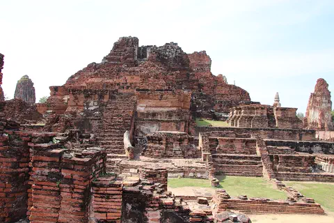
Ayutthaya, in Thailand, was founded in 1350 and became the second capital of the Siamese kingdom. From the 14th to the 18th centuries it grew into a center of trade and diplomacy. Today its brick ruins, tall towers and the remains of large monasteries are kept in a historical park, a UNESCO World Heritage Site since 1991.
-
 Watch
City
Bangkok
Bangkok, the capital of Thailand, lies on the delta of the Chao Phraya River, about 40 kilometers from the sea. It became the capital in 1782, when the new royal palace and temples were built. Once called the 'Venice of the East' for its canals, it is now a huge, busy city with skyscrapers and an elevated railway.
-
 Watch
City
Vientiane
Vientiane is the capital of Laos, on the left bank of the Mekong River. Lao Statistics Bureau figures give Vientiane Capital, the prefecture around the city, an estimated 844,020 people in mid-2015.
-
 Watch
City
Luang Prabang
Luang Prabang is a town in northern Laos, built on a peninsula where the Nam Khan River meets the Mekong. From the 14th to the 16th century it was the capital of the kingdom of Lane Xang, the 'Kingdom of a Million Elephants'. UNESCO lists the town as a World Heritage Site for the way it mixes traditional Lao buildings with buildings from colonial times.
-
 Watch
Natural wonder
Andaman Sea
The Andaman Sea is part of the eastern Indian Ocean, near Thailand and Myanmar, with the Andaman and Nicobar Islands nearby. Its rugged sea floor helps make large waves deep inside the water, and its islands have coral reefs and seagrass where dolphins and dugongs feed.
Explore next
-
Watch
 Country
Myanmar
Myanmar, also called Burma, is the northernmost country of Southeast Asia. Snowy mountains rise in the far north, and the long Irrawaddy River flows south through its heartland to a huge delta of rice fields. About 55 million people live there.
-
Watch
Landmark
Shwedagon Pagoda
The Shwedagon Pagoda is a huge Buddhist stupa covered in gold, on Singuttara Hill in the center of Yangon, Myanmar. Rebuilt and raised by kings and a queen over many centuries, it now stands 112 meters tall. Covered stairways climb the hill to it from the four directions.
-
Watch
City
Naypyidaw
Naypyidaw is the capital of Myanmar, in a wide basin in the center of the country. It is a new city: building work began in 2004 near the town of Pyinmana, and it was proclaimed the capital in March 2006. At the 2024 census, Naypyidaw, together with Pyinmana and Lewe, had 358,679 people.
-
 Watch
City
Abu Dhabi
Abu Dhabi is the capital of the United Arab Emirates. It began in the 1700s as a small settlement around fresh water on an island, guarded by a coral-stone watchtower. Before oil, it relied on fishing and pearl diving; since the 1960s, money from oil has turned it into a city of towers. An official estimate gave the city about 1.75 million people in 2023.
-
 Watch
City
Almaty
Almaty is the main city of Kazakhstan, in the southeast of the country at the foot of the Ala-Tau mountains. It was founded in 1854 where a Kazakh village called Almaty, 'village of apple trees', stood. It was the capital until 1998, and about 2,387,900 people lived there on 1 September 2026.
-
 Watch
City
Amman
Amman is the capital of Jordan, built on steep hills around a valley high on a plateau. Long ago it was a Roman city called Philadelphia, and its Roman theater, carved into a hillside, still holds about 6,000 people. Today the city spreads across the hills, with houses faced in pale stone. About 4.6 million people lived in Amman Governorate at the end of 2021.
-
 Watch
City
Ankara
Ankara is the capital of Türkiye, in the interior of Anatolia, about 200 kilometers from the Black Sea. People have lived here since the Stone Age, and Romans, Byzantines, Seljuks and Ottomans all left buildings behind. It became the capital in 1923, and today it is a city of government, universities and museums.
-
 Watch
City
Ashgabat
Ashgabat is the capital of Turkmenistan, in Central Asia. It lies at the foot of the Kopet Dag mountains, with the Karakum Desert to the north. The 2022 census counted 1,030,063 people, and Guinness World Records lists the city for its many white marble buildings.
For parents & teachers
What children will learn
- Locate Yangon in the Irrawaddy delta and explain what a delta is.
- Describe how a port can shape a city's growth and industries.
- Read a monsoon climate table with a very dry season and a very wet season.
- Compare census counts from 1983, 2014 and 2024, and talk about why a count can be uncertain.
Recommended ages: 3 to 17 · About 15 minutes
Talk about it
- Why might a big port grow up where rivers meet near the sea?
- How would life change between a month with 2 millimeters of rain and a month with 602?
- Why might a city's name be written in different ways in other languages?
Try at home or in class
- Delta tray: pour water slowly down a tray of sand and watch the channels split.
- Rain jars: mark the depth of February's and August's rain on two tall jars.
- Grid town: draw a town plan with streets in a grid, then one with winding streets, and compare.
Key vocabulary: delta, port, monsoon, pagoda, colonial, census
Where these facts come from
- Wikidata , Wikimedia Foundation (CC0 1.0)
- Natural Earth vector data , Natural Earth (NACIS) (Public domain)
- Rangoun , Encyclopaedia Universalis
- Myanmar: Regions, States, Cities and Towns , City Population (Thomas Brinkhoff), from the Myanmar Department of Population
- Yangon: climatological information , World Meteorological Organization, World Weather Information Service
- File:2016 Rangun, Dawny budynek Sądu Najwyższego (15).jpg (Marcin Konsek, 17 November 2016) , Wikimedia Commons
- Wikimedia Commons , Wikimedia Foundation (Per file (public domain, CC0, CC BY or CC BY-SA); see each media record)
Checked, not yet human-reviewed. Last updated November 1, 2026. Spotted a mistake? Tell us.