 Country
Africa
Angola
Angola is a big country in Africa, by the Atlantic Ocean. It has high plains, long rivers and a dry desert by the sea.
Angola is a large country in southwestern Africa, on the Atlantic Ocean. A narrow coast rises steeply to high plateaus, rivers such as the Cuanza run to the sea, and the Namib Desert reaches its far southwest. Its national statistics institute projects about 38.8 million people for 2026.
Angola, in southwestern Africa, rises from a narrow Atlantic coastal plain up a series of escarpments to highlands that culminate at Mount Moco (2,620 m) and slope east toward the center of the continent. Once the heart of the Kongo and Ndongo kingdoms and later a Portuguese colony, it became independent in 1975; INE Angola projects 38,778,554 people for 2026.
Photo: Lars Rohwer, CC BY-SA 3.0, via Wikimedia Commons
Discover Angola
Angola is a country in Africa.
Its west side is on the Atlantic Ocean. Most of the land is high and flat. Many rivers flow across it. The capital city is Luanda.
Angola is a big country in southwestern Africa, with a long coast on the Atlantic Ocean. It has many kinds of land: a dry, desert-like coast in the south, rainforest in the far north, rugged highlands and wide plateaus that cover most of the country.
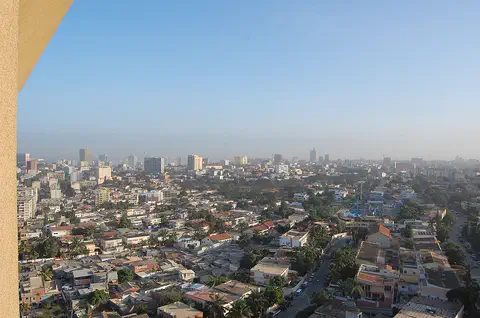
A small part of Angola, called Cabinda, lies separately to the north, between the Democratic Republic of the Congo and the Republic of the Congo. Angola's statistics institute projects about 38.8 million people for 2026. The capital, Luanda, is a large port city on the northern coast.
Britannica describes a broad variety of landscapes: the semidesert Atlantic coast that borders Namibia's 'Skeleton Coast', a sparsely populated rainforest interior, rugged southern highlands, the Cabinda exclave in the north, and densely settled towns along the northern coast and north-central river valleys. Cabinda's borders, between the Democratic Republic of the Congo and the Republic of the Congo, were settled in negotiations in Europe in 1891.
INE Angola, the national statistics institute, projects a population of 38,778,554 for 2026, on 1,246,700 square kilometers. Portuguese is the lingua franca and the language of government and education, alongside many Bantu languages. Luanda, the capital and commercial center, blends Portuguese-style colonial landmarks with traditional African housing and modern industry.
Cities and famous places
Luanda is the capital city.
It is a big port by the sea. Huambo is a city high on a plateau. Mbanza Kongo was the capital of an old kingdom.
Luanda, on the northern coast, has been a center of Angola since the Portuguese set up a colony there in 1575. It mixes Portuguese-style colonial landmarks with African-style housing and modern industry, and about 2.5 million people lived in the city in 2018. Farther south, Benguela and Lobito are neighboring port towns, and Namibe is the country's largest fishing center.
Inland, Huambo stands on the Bié Plateau, about 1,700 meters above the sea. In the far north, Mbanza Kongo was the capital of the Kingdom of Kongo, one of the largest states of southern Africa, from the 1300s to the 1800s. It is now a World Heritage Site.
The Portuguese established a colony at Luanda in 1575, and by the mid-1990s migration had swelled the city beyond two million people, and about 2.49 million lived there in 2018. Benguela and the port and industrial center of Lobito are traditional rivals on the coastal plain, Namibe is the southern port and largest fishing center, and Lubango dominates the Huíla highlands, while Huambo, at about 1,720 m, anchors the Bié Plateau.
UNESCO inscribed Mbanza Kongo in 2017. On a plateau at 570 m, it was the political and spiritual capital of the Kingdom of Kongo from the 14th to the 19th century, prosperous when the Portuguese arrived in the 15th century; the Portuguese added stone buildings, including several churches, to an urban center built of local materials. UNESCO notes that the kingdom lay at the center of the most important route of the trade in enslaved people to the Americas and the Caribbean, although no material trace of that trade has been found in the town.
Coast, plateaus and rivers
By the sea, the land is low and flat.
Then it climbs up steep slopes to high plains. The highest mountain is Mount Moco. The south coast is very dry. The north gets lots of rain.
From a narrow coastal plain, Angola's land climbs steeply up a series of cliffs and slopes called escarpments to rugged highlands. The Bié Plateau, east of Benguela, is above 1,500 meters, and Angola's highest point, Mount Moco near Huambo, reaches 2,620 meters. The eastern two-thirds is an almost flat plateau, covered in deep Kalahari sand.
The Cuanza, about 1,000 kilometers long, is the largest river entirely inside Angola. The Congo River forms part of the border in the north, and the Cunene in the south tumbles over the Ruacana Falls. Rain falls from September to May in the north but only from December to March in the south, and the southern coast is very dry.
The coastal plain narrows from about 200 km south of Luanda to about 25 km near Benguela. The Bié Plateau, above 1,500 m, covers about one-tenth of the country, and Mount Moco near Huambo is the highest point at 2,620 m; the eastern two-thirds is a featureless plateau of infertile windblown Kalahari sands falling to 500-1,000 m at the eastern border. The Lunda Divide separates north- and south-flowing rivers: the Cuango drains to the Congo, which forms the border with the Democratic Republic of the Congo for its final 145 km; the Cuanza (about 1,000 km) is the largest river entirely within Angola; the Cunene breaks through the escarpment at Ruacana Falls; and southeastern rivers feed the Zambezi and the Okavango.
The climate is tropical with a marked dry season, shaped by the intertropical convergence zone, the cold Benguela Current and elevation. Rainfall falls from about 1,800 mm in Cabinda's Maiombe forest and 1,450 mm at Huambo to 330 mm at Luanda and about 50 mm on the southernmost coast; average annual temperatures range from 26 °C at Soyo to 19 °C at Huambo. True desert is confined to the Namib in the far southwest.
Animals and plants of Angola
Elephants, giraffes and zebras live in Angola.
Lions and leopards live there too. The giant sable antelope lives in the south. A strange desert plant has two very long leaves.
Much of Angola is savanna, grassland with scattered trees. Its animals include leopards, lions and hyenas, along with elephants, hippopotamuses, giraffes, zebras, buffaloes, wildebeests, other antelopes and monkeys. Angola has many kinds of birds and reptiles, including crocodiles.
The giant sable antelope, found in the south, is especially at risk, and so are the gorillas and chimpanzees of the Maiombe forest, the black rhinoceros and the Angolan giraffe. In the Namib Desert grows the tumboa, or welwitschia, a plant with a deep root and just two broad leaves about 3 meters long that lie on the ground.
Britannica describes Angola's fauna as typical of African savanna: leopards, lions and hyenas; elephants, hippopotamuses, giraffes, zebras, buffaloes, wildebeests and other antelopes; monkeys, many birds and reptiles including crocodiles. About a dozen national parks and reserves exist, notably Iona National Park and Quiçama National Park, just south of Luanda, but checks on hunting largely broke down during the civil war. The giant sable antelope (Hippotragus niger variani) of the south is particularly vulnerable, and endangered populations include the gorillas and chimpanzees of the Maiombe forest, the black rhinoceros and the Angolan giraffe.
Dense rainforest once covered parts of Cabinda, the Malanje highlands and the Bié Plateau, but agriculture and logging have diminished it, and savanna now covers most of the country, from savanna-forest mosaic in the north to thorn scrub in the south; frequent fires mean its trees are usually fire-resistant. The Namib holds the tumboa (Welwitschia mirabilis), with a deep taproot and two flat leaves about 3 m long, and the cold Benguela Current makes marine life especially rich along the southern coast.
People, languages and culture
Many different peoples live in Angola.
Most people speak Portuguese. Many also speak languages like Umbundu, Kimbundu and Kikongo. Many dishes use palm oil and seafood. Music and dancing matter a lot, and the drum is the main instrument.
Angola's largest groups are the Ovimbundu, who speak Umbundu, and the Mbundu, who speak Kimbundu; each makes up about a quarter of the population. The Kongo, who speak Kikongo, live in the far north, and the Lunda, Chokwe, Ovambo, Herero and others live in other regions. Portuguese is spoken across the country and is used in schools and government.
Most people in Angola are Christian. Palm oil is an important part of many dishes, and many dishes feature seafood. At the harvest festival of Nganja, usually in April, children roast corn. The Chokwe people are known for their wooden sculptures, and drums such as the ngoma are traditional instruments.
Apart from a few Europeans and small groups of Northern Khoisan speakers such as the !Kung in the southeast, Angolans speak Bantu languages of the Niger-Congo family. The Ovimbundu (Umbundu) and Mbundu (Kimbundu) each make up about one-fourth of the population and the Kongo (Kikongo) about one-eighth; the Lunda, Chokwe and Ngangela live in the thinly populated east, and the Ovambo and Herero in the southwest. Portuguese was spoken by some in the Kongo kingdom as early as 1491; it became the lingua franca, and since independence the government has also recognized six African languages for teaching. About two-fifths of people are Roman Catholic and about two-fifths Protestant.
More than four-fifths of people were rural at the end of the colonial period, about three-fifths by the early 21st century. Britannica notes that the blend of Portuguese and African culture makes urban Luanda in some ways like Latin America. Palm oil and seafood feature in many dishes, Nganja is an April harvest festival, Chokwe wood sculpture and Cabinda ivory carving are celebrated arts, and the poet Agostinho Neto, Angola's first president, described the country as 'red with coffee, white with cotton, green with maize'.
A long history
People have farmed in Angola for a very long time.
Long ago, big kingdoms grew here, like the Kingdom of Kongo. Later, Portugal ruled the land. In 1975, Angola became its own country.
Farming peoples appeared in Angola between about 1000 and 500 BCE, and by the first centuries CE they were also working iron. By 1500, several large kingdoms covered the land. The largest was the Kingdom of Kongo in the north, with its capital at Mbanza Kongo, and another was Ndongo in the highlands.
Portuguese sailors reached Kongo in 1483, and in 1575 Portugal set up a colony at Luanda. For centuries the trade in enslaved people, who were shipped across the ocean, was the colony's main export, until it was banned in the 1800s. Angola remained a Portuguese colony until 1975, when it became an independent country.
Britannica traces most of Angola's modern population to farming cultures that appeared from about 1000 to 500 BCE and were working iron by the first centuries CE. By 1500 several kingdoms occupied the territory: Kongo, which emerged in the 14th century with its capital at Mbanza Kongo, was the largest and most centralized, and Ndongo, between the Cuanza and Lukala rivers, was its rival. Portuguese navigators reached Kongo in 1483; its king converted to Christianity, and his son Afonso I spread literacy in Portuguese. Disputes over the trade in enslaved people led Portugal toward Ndongo and to its colony at Luanda in 1575, and later wars there brought Portugal more territory despite the resistance of Queen Nzinga Mbande of Ndongo and Matamba.
Enslaved people were Angola's major export, and Portugal was actively involved in acquiring them; the export was banned in 1836, though the trade continued until the Brazilian market closed. An anticolonial struggle that began in 1961 led to independence in 1975, when the Portuguese withdrew in November without handing power to any movement. Britannica records a civil war from 1975 to 2002 that left much of the country in ruins; after it ended in 2002, the government and private organizations began renovating or rebuilding cultural institutions damaged in the war.
Angola on the map
Find Angola on the globe.
It is in Africa, below the middle. The Atlantic Ocean is on its west side. A small piece of Angola sits apart, to the north.
Angola is in southwestern Africa, south of the Equator, with the Atlantic Ocean to the west. Its neighbors are the Democratic Republic of the Congo to the north and northeast, Zambia to the southeast and Namibia to the south.
Cabinda, a small part of Angola, lies separately to the north, on the coast between the Democratic Republic of the Congo and the Republic of the Congo. The Cunene River forms part of the border with Namibia as it flows to the sea.
Angola covers 1,246,700 square kilometers of southwestern Africa. It borders the Democratic Republic of the Congo to the north and northeast, Zambia to the southeast and Namibia to the south, with the Atlantic to the west; the Cabinda exclave, on the coast between the two Congos, also borders the Republic of the Congo. The Congo River forms the boundary with the Democratic Republic of the Congo for its final 145 km, and below Ruacana Falls the Cunene marks the boundary with Namibia.
The Cazombo region forms a far eastern extension crossed by the Zambezi. The coastal plain is underlain by oil-bearing formations over its northern two-thirds, and the river gravels of the northeast contain diamonds.
- Neighbors
- Democratic Republic of the Congo, Republic of the Congo (by Cabinda), Zambia, Namibia
- Coastal plain
- about 25 to 200 km wide
- Highest point
- Mount Moco, 2,620 m
- Largest river entirely in Angola
- Cuanza, about 1,000 km
- People (INE projection, 2026)
- 38,778,554
Amazing facts
-
A desert plant in Angola has only two leaves.
The tumboa, or welwitschia, of the Namib Desert has a deep root and just two broad, flat leaves about 3 meters long.
Welwitschia mirabilis, called tumboa, grows in the Namib of Angola's far southwest, with a deep taproot and two flat leaves about 3 m long lying along the desert floor.
-
Part of Angola sits apart from the rest.
Cabinda, a part of Angola, lies separately to the north, on the coast between the Democratic Republic of the Congo and the Republic of the Congo.
The borders of the Cabinda exclave, between the two Congos, were finally fixed in negotiations in Europe in 1891; its Maiombe forest is Angola's wettest place, with about 1,800 mm of rain a year.
-
Angola's capital gets little rain.
Luanda, on the dry coast, gets only about 330 millimeters of rain a year, while Huambo, up on the plateau, gets about 1,450 millimeters.
Rainfall decreases rapidly from north to south and toward the coast: about 1,800 mm in the Maiombe forest, 1,450 mm at Huambo, 330 mm at Luanda and as little as 50 mm on the southernmost coast.
-
Long ago, some people in Kongo read Portuguese.
In the Kingdom of Kongo, some people could speak and read Portuguese as early as 1491.
Britannica notes that in the Kongo kingdom some people could speak and read Portuguese as early as 1491, and that Afonso I established literacy in Portuguese there.
-
At a harvest festival in Angola, children roast corn.
At Nganja, a harvest festival usually held in April, children in Angola roast corn.
Nganja, usually celebrated in April, is a harvest festival during which children roast corn; Britannica also notes palm oil and seafood as central to many Angolan dishes.
Words to know
- plateau
- a large area of high, mostly flat land
- escarpment
- a long, steep slope or cliff where high land drops to lower land
- exclave
- a part of a country that is separated from the rest of it by other countries
- savanna
- a wide grassland with scattered trees
- lingua franca
- a language that people with different first languages use to talk to each other
- colony
- a land ruled by another country far away
- independence
- when a country rules itself
Discovery challenge
-
What is the capital city of Angola?
Which port city is the capital of Angola?
Which city, where Portugal set up a colony in 1575, is Angola's capital?
- Huambo
- Luanda
- Lobito
Show the answer
Luanda
Luanda is the capital. It is by the sea.
Luanda, a big port on the northern coast, is the capital. Huambo is on the plateau, and Lobito is a port farther south.
The Portuguese established their colony at Luanda in 1575; it is now Angola's capital and commercial center.
-
Which language do most people in Angola speak?
Which language is spoken across Angola and used in schools and government?
Which language is Angola's lingua franca and the language of government and education?
- Portuguese
- Japanese
- German
Show the answer
Portuguese
Most people in Angola speak Portuguese.
Portuguese is spoken across the country, and many people also speak Umbundu, Kimbundu, Kikongo or other languages.
Portuguese developed as the lingua franca and is used for education and official documents; six African languages are recognized for teaching.
-
Which desert plant in Angola has just two long leaves?
Which plant of the Namib Desert has only two broad leaves about 3 meters long?
Which Namib plant has a deep taproot and two flat leaves about 3 m long?
- Bamboo
- Tumboa (welwitschia)
- Lotus
Show the answer
Tumboa (welwitschia)
The tumboa has just two long leaves.
The tumboa, or welwitschia, grows in the Namib Desert in Angola's far southwest.
Welwitschia mirabilis, the tumboa, grows in the Namib, the only true desert in Angola.
-
Which long river flows only inside Angola?
Which is the largest river entirely inside Angola?
Which river, about 1,000 km long, is the largest entirely within Angola's borders?
- The Nile
- The Amazon
- The Cuanza
Show the answer
The Cuanza
The Cuanza flows only inside Angola.
The Cuanza, about 1,000 kilometers long, flows across Angola and reaches the sea south of Luanda.
The Cuanza drains the central plateau, runs north for about half its length, then bends west through the escarpment to the sea.
-
In which year did Angola become its own country?
In which year did Angola become independent?
In which year did Portugal withdraw and Angola become independent?
- 1975
- 1875
- 2015
Show the answer
1975
Angola became its own country in 1975.
Angola was a Portuguese colony until 1975, when it became independent.
An anticolonial struggle that began in 1961 led to independence in 1975; the Portuguese withdrew in November.
Places to discover in Angola
-
 Watch
Natural wonder
River Congo
The Congo is Africa's second-longest river, about 4,700 kilometers long. It curves in a giant arc through the rainforests of central Africa and empties into the Atlantic Ocean. Rain falls in its basin all year, so it carries a huge amount of water, and its wild lower rapids are home to about 320 kinds of fish, about 90 of them found nowhere else.
-
 Watch
Natural wonder
Kalahari Desert
The Kalahari is a giant sandy plain in southern Africa, covering almost all of Botswana and parts of Namibia and South Africa. It stretches about 1,600 kilometers from north to south. Its southwest is a true desert, with long red dunes, while its north is green with woodlands and even has a huge swamp, the Okavango Delta.
-
 Watch
Natural wonder
Namib
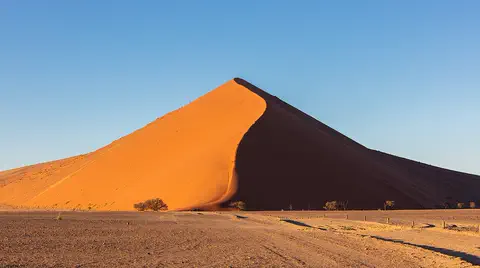
The Namib is a cool desert that runs for about 1,900 kilometers along Africa's Atlantic coast, from Angola through Namibia into South Africa. It gets almost no rain, but cold ocean water makes thick fog that drifts inland. UNESCO says its Namib Sand Sea is the only coastal desert in the world with huge dune fields influenced by fog.
Animals of Angola
-
 Watch
3D
Animal
Giraffe
Giraffes are the tallest animals on Earth. A long neck and a long dark tongue let them eat leaves from treetops that other animals cannot reach, and their patchy coats help them blend into the shade of the trees.
-
 Watch
Animal
Western gorilla
The western gorilla is a great ape, one of our closest animal relatives. It lives in family groups led by a big silverback male, eats leaves and fruit in the rainforests of central Africa, and is quiet and peaceful unless it feels threatened.
Explore next
-
Watch
Natural wonder
River Congo
The Congo is Africa's second-longest river, about 4,700 kilometers long. It curves in a giant arc through the rainforests of central Africa and empties into the Atlantic Ocean. Rain falls in its basin all year, so it carries a huge amount of water, and its wild lower rapids are home to about 320 kinds of fish, about 90 of them found nowhere else.
-
Watch
Natural wonder
Kalahari Desert
The Kalahari is a giant sandy plain in southern Africa, covering almost all of Botswana and parts of Namibia and South Africa. It stretches about 1,600 kilometers from north to south. Its southwest is a true desert, with long red dunes, while its north is green with woodlands and even has a huge swamp, the Okavango Delta.
-
Watch
3D
Animal
Giraffe
Giraffes are the tallest animals on Earth. A long neck and a long dark tongue let them eat leaves from treetops that other animals cannot reach, and their patchy coats help them blend into the shade of the trees.
-
Watch
Animal
Western gorilla
The western gorilla is a great ape, one of our closest animal relatives. It lives in family groups led by a big silverback male, eats leaves and fruit in the rainforests of central Africa, and is quiet and peaceful unless it feels threatened.
-
Watch
Natural wonder
Namib
The Namib is a cool desert that runs for about 1,900 kilometers along Africa's Atlantic coast, from Angola through Namibia into South Africa. It gets almost no rain, but cold ocean water makes thick fog that drifts inland. UNESCO says its Namib Sand Sea is the only coastal desert in the world with huge dune fields influenced by fog.
-
 Watch
 Country
Democratic Republic of the Congo
The Democratic Republic of the Congo, or DR Congo, is the second-largest country in Africa. The mighty Congo River curves through its rainforests, volcanoes rise in the east, and its capital, Kinshasa, is a center of music, fashion and popular culture.
-
 Watch
 Country
Ethiopia
Ethiopia is a country on the Horn of Africa with no coast. Much of it is high, rugged land cut by the Great Rift Valley, it is one of the world's oldest countries, and more than 110 million people live there.
-
 Watch
 Country
Kenya
Kenya is a country in East Africa, crossed by the equator. It has the snow-capped Mount Kenya, the deep Great Rift Valley, Lake Victoria and a long Indian Ocean coast, and about 54 million people live there, many of them speaking Swahili.
For parents & teachers
What children will learn
- Locate Angola on Africa's Atlantic coast and name its neighbors and the Cabinda exclave.
- Describe how the land rises from the coast up escarpments to high plateaus, and how rainfall changes from north to south.
- Describe Angola's languages, foods and arts without treating its people as one single culture.
- Outline Angola's history from early farmers and the Kingdom of Kongo to independence in 1975.
Recommended ages: 3 to 17 · About 15 minutes
Talk about it
- Why might a coast next to a cold ocean current get very little rain?
- Many people in Angola speak more than one language. When might it help to share one common language?
- Why do you think people protect old towns like Mbanza Kongo?
Try at home or in class
- Stack books to make a staircase from a low 'coast' to a high 'plateau', and roll a marble to see which way water would flow.
- Compare rainfall: fill one cup to 33 millimeters (Luanda) and another to 145 millimeters (Huambo) to show a tenth of each city's yearly rain.
Key vocabulary: plateau, escarpment, exclave, savanna, lingua franca, colony, independence
Where these facts come from
- Wikidata , Wikimedia Foundation (CC0 1.0)
- Natural Earth vector data , Natural Earth (NACIS) (Public domain)
- UNESCO World Heritage List , UNESCO World Heritage Centre (Linked as a reference; site facts come from Wikidata)
- Angola , Encyclopaedia Britannica
- Angola: People , Encyclopaedia Britannica
- Angola: Cultural life , Encyclopaedia Britannica
- Angola: History , Encyclopaedia Britannica
- Angola: Independence and civil war , Encyclopaedia Britannica
- Mbanza Kongo, Vestiges of the Capital of the former Kingdom of Kongo , UNESCO World Heritage Centre
- Instituto Nacional de Estatística (home page indicators: Projecção da População 2026) , INE Angola
- PlayOwl region table, version 1 , PlayOwl (PlayOwl original data)
- flag-icons 7.5.0 , Panayiotis Lipiridis and contributors (MIT)
- Wikimedia Commons , Wikimedia Foundation (Per file (public domain, CC0, CC BY or CC BY-SA); see each media record)
Checked, not yet human-reviewed. Last updated October 24, 2026. Spotted a mistake? Tell us.