
 Country
Africa
Comoros
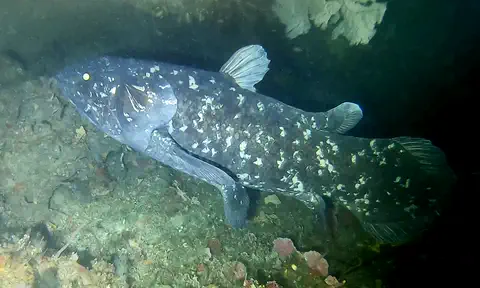
Comoros is a country of volcanic islands in the Indian Ocean. Sweet-smelling flowers and vanilla grow there. A very old kind of fish, the coelacanth, lives in its deep sea.
Comoros is made of three volcanic islands between Madagascar and the coast of Africa. People call them the perfumed islands, because of their fragrant plants such as vanilla and ylang-ylang. Mount Karthala, an active volcano, is the highest point, and the 2017 census counted 758,316 people.
The Union of the Comoros comprises Grande Comore, Mohéli and Anjouan at the northern end of the Mozambique Channel; the fourth main island of the archipelago, Mayotte, is claimed by Comoros but administered by France. Shaped by African, Arab, Malagasy and French influences and once a stop on Indian Ocean trade routes, Comoros became independent in 1975. The 2017 census counted 758,316 residents, most of them Sunni Muslims who speak Comorian.
Photo: Woodlouse, CC BY-SA 2.0, via Wikimedia Commons
Discover Comoros
Comoros is a country made of islands.
The islands are in the warm Indian Ocean, near Africa. Volcanoes made them. The capital city is Moroni.
Comoros is a country of three main islands in the Indian Ocean, about 290 kilometers off the east coast of Africa, between Madagascar and Mozambique. The islands are Grande Comore, Mohéli and Anjouan. A fourth island in the same group, Mayotte, is run by France, though Comoros says it should belong to Comoros.
The 2017 census counted 758,316 people. The capital, Moroni, is on Grande Comore. People speak Comorian, a language related to Swahili, and French and Arabic are official languages too.
The Comoro Islands lie at the northern end of the Mozambique Channel, about 290 km off East Africa. Under the 2001 constitution, Grande Comore (N'gazidja), Mohéli (Mwali) and Anjouan (Ndzuwani) form the Union of the Comoros, each with partial autonomy; the presidency has rotated among the islands.
INSEED's 2017 general census counted 758,316 residents (381,812 men and 376,504 women), 235,762 of them urban. Britannica gives Grande Comore about half the population, Anjouan about two-fifths and Mohéli less than one-tenth, with about two-fifths of people under 15. Comorian (Shikomor), French and Arabic are official, and Islam is the state religion. Comoros joined the World Trade Organization in 2024.
Three islands, three characters
Grande Comore is the biggest island.
Moroni has a harbor with boats. Mohéli is the smallest island, with thick forests. Anjouan has a tall mountain in the middle.
Grande Comore is the biggest and highest island. Moroni, the capital, lies on its west coast below the volcano Mount Karthala, and the photo shows its harbor. The island has no rivers that flow all year, so people have long collected rainwater in tanks.
Mohéli is the smallest island, with fertile valleys and forested hills; its main town is Fomboni. Anjouan is shaped like a triangle, with a volcanic mountain in the middle and the town of Mutsamudu on its northwest coast.
Grande Comore rises at its south end to Mount Karthala; north of the volcano is a rocky plateau averaging about 600 m with shallow soils and no perennial streams. Rain sinks so deeply into the porous lava that wells are hard to drill, so water traditionally came from rainy-season reservoirs and coastal freshwater springs (foumbous). Moroni has most of the country's commercial and manufacturing facilities, and an international airport is nearby.
Mohéli is a plateau averaging about 300 m, ending in a western ridge above 790 m, with fertile valleys and thick forests; Fomboni has a port built with EU funds in the early 1990s. Triangular Anjouan rises to Mount Ntingui (about 1,580 m); erosion has made many areas no longer arable. Mutsamudu, its chief town, had its port modernized in the mid-1980s.
Volcanoes and perfumed islands
The islands grew up from the sea floor as volcanoes.
Mount Karthala is still active. Sandy beaches and coral reefs ring the islands. Flowers make the air smell sweet.
The Comoro Islands rose from the floor of the Indian Ocean as volcanoes. Mount Karthala on Grande Comore is an active volcano, 2,361 meters high, and it has erupted more than a dozen times in the last 200 years. Dark lava flows reach down to some beaches.
It is warm all year, with a cooler dry season from May to October and a hot, rainy season from November to April, when tropical cyclones are most likely. Mangroves line the coasts, with coconut palms, mangoes and bananas higher up and forest on the mountains. Jasmine, frangipani and lemongrass fill the air with scent.
Britannica describes islands built by volcanic activity, with coral reefs, sandy beaches, coconut groves, mangroves, recent lava flows and rounded rocks from older eruptions. Karthala (2,361 m) has erupted more than a dozen times in two centuries; Mayotte is the oldest of the four main islands.
The dry season runs May–October and the humid season November–April; the kashkazi monsoon brings afternoon highs of about 33 °C in November, and January rainfall reaches 275–375 mm. Annual rain ranges from about 1,100 to 2,900 mm, highest on windward northeast slopes. Less than one-sixth of the land remains forested, mainly because of firewood demand; vegetation runs from mangroves through coconut, mango and banana zones to forest up to about 1,800 m, with broom, heather and lichens on the highest peaks.
Coelacanths, fruit bats and turtles
A very old kind of fish lives in the deep sea here.
It is called a coelacanth. Big fruit bats fly at night. Sea turtles swim along the coasts.
Deep in the waters around Comoros lives the coelacanth, a rare fish that scientists once thought had died out long ago. Its fossil relatives date back about 400 million years. The photo was taken in South Africa, another home of the coelacanth.
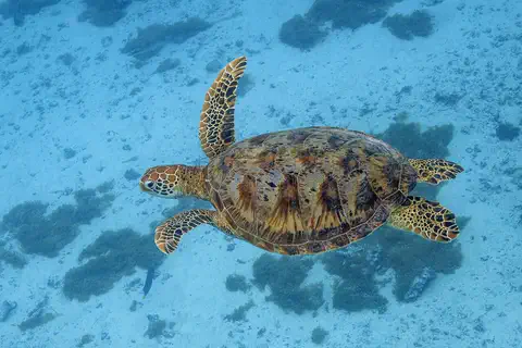
The islands' animals are like those of Madagascar. There are lemurs and fruit bats found only on these islands, plus guinea fowl, egrets, civets, small lizards and giant land crabs. Turtles are common along the coasts. As the number of people grows, several species are in danger.
Britannica lists Comorian waters as a habitat of the coelacanth, a fish long thought extinct whose fossil record goes back about 400 million years; coelacanths caught there provide some income to fishers. Land fauna resembles Madagascar's, with species of lemurs and fruit bats peculiar to the islands, guinea fowl and egrets, civets, small lizards and giant land crabs. Turtles abound along the coasts.
Britannica notes that the expanding human population has put a number of species under threat of extinction, and deforestation for firewood is shrinking forest habitat. The coelacanth photo was taken 69 m deep off KwaZulu-Natal, South Africa, in 2019, and the turtle photo in French Polynesia.
People, vanilla and ylang-ylang
Most people speak Comorian.
Families fish and grow bananas and cassava. Farms grow vanilla and sweet-smelling flowers. Many people are Muslim.
Comorians have ancestors from Africa, Madagascar, Arabia, Persia and Southeast Asia. Most people speak a version of Comorian, a Bantu language related to Swahili. French is the language of government, and most people are Muslim.
More than two-thirds of people live in the countryside. Families grow cassava, sweet potatoes, bananas and rice and keep chickens and goats, but much food must be bought from abroad. Plantations grow vanilla, coconuts, cloves and ylang-ylang, a flower whose oil is used in perfume.
Britannica describes a mix of Malay immigrants, Arab and Persian traders, Malagasy and African peoples. Most speak island varieties of Comorian (Shikomoro), a Bantu language related to Swahili, written in Arabic script; Shingazidja, the Grande Comore dialect, appears in the government weekly Al Watwan. Most Comorians are Sunni Muslims.
The economy rests on subsistence farming and fishing; cassava, sweet potatoes, bananas and mountain rice are grown, but much food is imported. Plantations produce vanilla (mostly Grande Comore and Anjouan), perfume plants such as ylang-ylang (particularly Anjouan), coconuts (Mohéli), coffee, cloves and cacao. Tuna in Comorian waters has mostly been fished by EU fleets. Britannica notes that educated and skilled workers have long left for France, and that political instability has held back tourism.
Traders, sultans and independence
Long ago, sailors and traders came to the islands.
Sultans ruled the islands for many years. Then France ruled. In 1975 Comoros became independent.
People may have lived on the islands by the 500s CE. Settlers came from Southeast Asia, Africa and Madagascar, and Arab traders arrived too. Later, Persian settlers set up small kingdoms ruled by sultans, and the islands became busy stops for trade around the Indian Ocean.
France took Mayotte in 1843 and the other three islands in 1886. Comoros declared independence on July 6, 1975, but Mayotte stayed with France. Since then the islands have had many changes of government, and in 2001 a new constitution gave each island its own local government.
People of Malayo-Polynesian descent may have lived on the islands by the 5th or 6th century CE, joined by Africans, Malagasy and Arabs; Shirazi Persians are thought to have later established Sunni Islam and sultanates that traded spices and enslaved people. The islands first appeared on a European map in 1527.
France took Mayotte in 1843 and placed the other islands under protection in 1886; they became an overseas territory in 1947 and gained internal autonomy in 1961. In 1974 majorities on three islands voted for independence while most on Mayotte favored French rule; President Ahmed Abdallah declared the whole archipelago independent on July 6, 1975, and the UN recognized it as one nation, but France kept Mayotte, which became a French overseas department in 2011. The following decades saw repeated coups and, in 1997, secession attempts on Anjouan and Mohéli, resolved by the 2001 constitution of the Union.
Comoros on the map
Find Comoros on the globe.
Look at the east side of Africa. Find the big island of Madagascar. Comoros is a few small islands to its northwest.
Comoros lies in the Indian Ocean at the north end of the Mozambique Channel, the stretch of sea between Mozambique and Madagascar. It has no land borders.
From northwest to southeast the main islands are Grande Comore, Mohéli, Anjouan and then Mayotte, which France runs.
The archipelago runs northwest to southeast: Grande Comore, Mohéli, Anjouan and Mayotte. Britannica notes that Mayotte is claimed by Comoros, a claim recognized by the UN General Assembly, but that its status is unsettled and France administers it as an overseas department.
The islands are too small for PlayOwl's world map to draw as shapes, so the globe marks them with points. Wikidata gives Comoros an area of 2,034 km².
- Distance from Africa
- about 290 km
- Highest point
- Mount Karthala, 2,361 m (active volcano)
- Forest cover
- less than one-sixth of the land
- People (2017 census)
- 758,316
Amazing facts
-
Comoros is called the perfumed islands.
The Comoro Islands have been called the perfumed islands because of their fragrant plants.
Britannica notes the archipelago has been called the 'perfumed islands' for its fragrant plant life, including ylang-ylang, jasmine and frangipani.
-
A fish people thought had died out lives near Comoros.
The coelacanth, a rare fish once thought to be extinct, lives in the waters around Comoros.
Comorian waters are one of the habitats of the coelacanth, whose fossil remains date to about 400 million years ago.
-
Rain disappears into the rocks on Grande Comore.
On Grande Comore, rain sinks so deep into the old lava that wells are hard to dig, so people save rainwater in tanks.
Rain sinks so deeply into Grande Comore's hardened lava and porous rock that wells are difficult to drill; reservoirs and coastal springs supply much of its water.
-
Mount Karthala has erupted many times.
Mount Karthala has erupted more than a dozen times in the past 200 years.
Karthala, at 2,361 m, has erupted more than a dozen times in the past two centuries.
Words to know
- archipelago
- a group or chain of islands
- active volcano
- a volcano that has erupted in recent times and could erupt again
- sultan
- a ruler in some Muslim countries in the past
- plantation
- a large farm where one crop, such as vanilla or coconuts, is grown to sell
- porous
- full of tiny holes that let water soak through
- living fossil
- a living animal or plant very similar to relatives known only from very old fossils
Discovery challenge
-
What made the islands of Comoros?
How did the Comoro Islands form?
According to Britannica, the Comoro Islands emerged from the ocean floor as a result of what?
- Volcanoes
- Glaciers
- Sand dunes
Show the answer
Volcanoes
Volcanoes made the islands.
They rose from the ocean floor as volcanoes, and Mount Karthala is still active.
Volcanic activity built them; Karthala remains active.
-
What is the capital city of Comoros?
Which town on Grande Comore is the capital of Comoros?
Which city, in the shadow of Karthala, holds most of the country's commerce?
- Moroni
- Fomboni
- Antananarivo
Show the answer
Moroni
Moroni is the capital.
Moroni is the capital. Fomboni is on Mohéli, and Antananarivo is the capital of Madagascar.
Moroni, on Grande Comore's west coast.
-
Which rare fish lives in the deep sea near Comoros?
Which fish, once thought to be extinct, lives in Comorian waters?
Which fish, whose fossil record reaches about 400 million years, lives in Comorian waters?
- Goldfish
- Coelacanth
- Salmon
Show the answer
Coelacanth
The coelacanth lives there.
The coelacanth was once thought to be extinct.
The coelacanth; coelacanths caught there bring some income to fishers.
-
Which language do most people in Comoros speak?
Most Comorians speak a version of which language, related to Swahili?
Which Bantu language, written in Arabic script, do most Comorians speak?
- Comorian
- English
- Portuguese
Show the answer
Comorian
Most people speak Comorian.
Comorian is related to Swahili. French and Arabic are official too.
Comorian (Shikomoro), in island varieties such as Shingazidja.
Places to discover in Comoros
Animals of Comoros
-
Watch
3D
Animal
West Indian Ocean coelacanth
The West Indian Ocean coelacanth is a large, blue, spotted fish that lives in deep, rocky waters off eastern Africa. Its group was known only from fossils and thought to have died out about 66 million years ago, until a living one was found in South Africa in 1938.
-
 Watch
Animal
Green sea turtle
The green sea turtle is the largest sea turtle with a hard shell. It lives in warm seas around the world and, unlike other sea turtles, grown-ups eat mostly seagrass and algae. Females swim hundreds or even thousands of kilometers to lay their eggs on the beaches where they hatched long ago.
Explore next
-
Watch
City
Moroni
Moroni is the capital and largest town of the Comoros, a country of islands in the Indian Ocean. It lies on the southwest coast of the island of Grande Comore. In the 2017 census, 74,749 people were counted there.
-
 Watch
 Country
Madagascar
Madagascar is the fourth-largest island in the world, in the Indian Ocean off southeastern Africa. It split from other land more than 60 million years ago, so many of its plants and animals, such as its lemurs, live nowhere else. About 32.7 million people lived there in 2025.
-
 Watch
 Country
Mozambique
Mozambique stretches along the Indian Ocean coast of southeastern Africa. The great Zambezi River cuts through its middle, its beaches face the island of Madagascar, and parks like Gorongosa are home to elephants and lions. About 35.6 million people lived there in 2025, and Portuguese is the official language.
-
 Watch
 Country
Mayotte
Mayotte is a group of volcanic islands in the Mozambique Channel, between Africa and Madagascar. France governs it as an overseas department, and Comoros also claims it. It is ringed by one of the largest lagoons in the Indian Ocean, where humpback whales raise their calves, and a full census by INSEE, France's statistics office, counted 323,153 people on 1 January 2026.
-
Watch
3D
Animal
West Indian Ocean coelacanth
The West Indian Ocean coelacanth is a large, blue, spotted fish that lives in deep, rocky waters off eastern Africa. Its group was known only from fossils and thought to have died out about 66 million years ago, until a living one was found in South Africa in 1938.
-
Watch
Animal
Green sea turtle
The green sea turtle is the largest sea turtle with a hard shell. It lives in warm seas around the world and, unlike other sea turtles, grown-ups eat mostly seagrass and algae. Females swim hundreds or even thousands of kilometers to lay their eggs on the beaches where they hatched long ago.
-
 Watch
 Country
Democratic Republic of the Congo
The Democratic Republic of the Congo, or DR Congo, is the second-largest country in Africa. The mighty Congo River curves through its rainforests, volcanoes rise in the east, and its capital, Kinshasa, is a center of music, fashion and popular culture.
-
 Watch
 Country
Ethiopia
Ethiopia is a country on the Horn of Africa with no coast. Much of it is high, rugged land cut by the Great Rift Valley, it is one of the world's oldest countries, and more than 110 million people live there.
For parents & teachers
What children will learn
- Locate Comoros and name its three islands and the island of Mayotte.
- Explain how volcanoes built the islands and why Grande Comore has no permanent rivers.
- Describe what the islands grow and why vanilla and ylang-ylang matter.
- Outline Comoros' history from Indian Ocean trade to independence in 1975.
Recommended ages: 3 to 17 · About 15 minutes
Talk about it
- If rain soaked straight into the ground where you live, how might you collect water?
- Why might the people of one island vote differently from those on the others?
- Why is finding a living coelacanth so exciting for scientists?
Try at home or in class
- Pour water onto a sponge and onto a plate side by side: the sponge, like porous lava, soaks it up while the plate lets it run off.
- Smell vanilla extract and a few spices from the kitchen, and talk about how plants like these are grown on Comoros' farms.
Key vocabulary: archipelago, active volcano, sultan, plantation, porous, living fossil
Where these facts come from
- Wikidata , Wikimedia Foundation (CC0 1.0)
- Natural Earth vector data , Natural Earth (NACIS) (Public domain)
- Comoros (land, relief, climate, plant and animal life) , Encyclopaedia Britannica
- Comoros: People (languages, religion, settlement, economy) , Encyclopaedia Britannica
- Comoros: History , Encyclopaedia Britannica
- RGPH 2017: principaux indicateurs démographiques (Comores 758,316) , Institut National de la Statistique et des Études Économiques et Démographiques (INSEED), Comoros
- PlayOwl region table, version 1 , PlayOwl (PlayOwl original data)
- flag-icons 7.5.0 , Panayiotis Lipiridis and contributors (MIT)
- Wikimedia Commons , Wikimedia Foundation (Per file (public domain, CC0, CC BY or CC BY-SA); see each media record)
Checked, not yet human-reviewed. Last updated November 1, 2026. Spotted a mistake? Tell us.