
 Country
Australia and Oceania
Fiji
Fiji is a country made of many islands in the Pacific Ocean. Coral reefs ring its islands. People there love rugby.
Fiji is a country of about 300 islands and 540 islets in the South Pacific, around a sea called the Koro Sea. About 100 of the islands have people living on them. The capital, Suva, is on the largest island, Viti Levu. The 2017 census counted about 885,000 people.
Fiji is an archipelago of some 300 islands and 540 islets about 2,100 km north of Auckland, New Zealand. Indigenous Fijians make up more than half the population and Fijians of Indian descent about two-fifths. A British colony from 1874, it became independent on October 10, 1970. The 2017 census counted 884,887 people.
Photo: Maksym Kozlenko, CC BY-SA 4.0, via Wikimedia Commons
Discover Fiji
Fiji is made of lots of islands.
The Pacific Ocean is all around. The biggest island is Viti Levu. The capital city is Suva.
Fiji is in the South Pacific Ocean, about 2,100 kilometers north of Auckland in New Zealand. It has about 300 islands and 540 tiny islets, spread across a huge area of ocean. Only about 100 of the islands have people living on them.
The largest island, Viti Levu, means 'Great Fiji', and the capital, Suva, is on its southeast coast. English, Fijian (iTaukei) and Hindi are the languages used for official purposes, and most people speak at least two languages. The 2017 census counted about 885,000 people.
Britannica describes Fiji as an archipelago surrounding the Koro Sea, about 2,100 km north of Auckland: some 300 islands and 540 islets scattered over about 3,000,000 km² of ocean, about 100 of them inhabited. Viti Levu ('Great Fiji') holds the capital, Suva.
The Fiji Bureau of Statistics' 2017 census counted 884,887 people on census night, up from 837,271 in 2007. Wikidata gives a land area of 18,274 km². Under the 2013 constitution, English, iTaukei (Fijian) and Hindi are used for official purposes; the 1997 constitution had named English, Fijian and Fijian Hindi as equal official languages. The currency is the Fijian dollar.
Suva, Lautoka and old Levuka
Suva is the capital city.
It is by the sea. The photo shows Suva. Levuka is an old town with little buildings by the beach.
Suva, the capital, is on the southeast coast of Viti Levu, and about one in four Fijians lives there. Lautoka, in the northwest of Viti Levu, is the center of the sugar industry and has a big port. Labasa, on Vanua Levu, is a center for sugar production too.
On the small island of Ovalau is Levuka, Fiji's first colonial capital. Its low buildings stand among coconut and mango trees along the beach, below the slopes of an old volcano. It is a World Heritage Site.
About half of Fijians are urban. The three largest urban centers are on Viti Levu: Suva, with about one-fourth of the population; Nasinu, a fast-growing suburb of Suva; and Lautoka, the center of the sugar industry with a major port. Labasa on Vanua Levu is a center for administration, services and sugar. The Fiji Museum, in Suva's Thurston Botanical Gardens, holds a fine collection of canoes.
UNESCO inscribed Levuka Historical Port Town on Ovalau in 2013. Developed from the 1820s as a commercial port by American and European settlers, it became Fiji's first colonial capital after Fiji was peacefully ceded to Britain by Tui (King) Cakobau in 1874, and UNESCO calls it a rare example of a late colonial port town shaped by the Indigenous community.
Volcanic islands and coral reefs
Fiji's islands were made by volcanoes and coral.
Mountains rise in the middle. Coral reefs ring the islands. It is warm all year.
Fiji's islands were built mostly by volcanoes, by layers of sediment and by coral. Viti Levu is so big that it covers more than half of Fiji's land. A jagged range of mountains runs down its middle, and Mount Tomanivi, 1,324 meters high, is the highest point in Fiji.
Coral reefs, rocks and shallow shoals surround the islands. Almost half of Fiji is still forest. It rains most from November to March, the season when tropical cyclones can strike, and the eastern sides of the big islands are much wetter than the western sides.
Built on an ancient submerged platform, the islands are largely products of volcanism, sedimentation and coral growth. Viti Levu (about 10,000 km²) has a jagged north–south divide with several peaks above 900 m, including Tomanivi (formerly Mount Victoria), 1,324 m, Fiji's highest point; the Rewa, Navua, Sigatoka and Ba rivers rise there. Vanua Levu covers about 5,540 km². Most other islands, in the Lomaiviti, Lau and Yasawa groups, are volcanic, and reefs and shoals make the Koro Sea hazardous to navigate.
Suva averages about 29 °C summer highs and 20 °C winter lows. Rain peaks from November to March, when tropical cyclones strike perhaps once every two years. Windward eastern sides get about 3,000 mm a year, western sides nearer 1,800 mm, a sharp contrast in climate and farming. Almost half of Fiji is forested, with dry grasslands in the west.
Reef fish, turtles and the Fiji petrel
Fish and sharks swim on Fiji's coral reefs.
Sea turtles lay eggs on its beaches. A seabird called the Fiji petrel flies over the sea.
Fiji has a huge coral reef called the Great Sea Reef, along the northwest coasts of its two biggest islands. WWF calls it the third-largest barrier reef in the world. Endangered humphead wrasses, bumphead parrotfish, groupers and sharks live there, and local communities protect turtle nesting beaches.
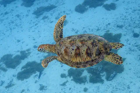
The Fiji petrel is a seabird that has been photographed off the coast of Gau Island. Most land animals in Fiji, such as pigs, cattle and horses, are farm animals, and mongooses were brought in to hunt snakes and rats. The turtle in the photo was photographed in French Polynesia.
WWF describes the Great Sea Reef (Cakaulevu), bordering the northwest coasts of Viti Levu and Vanua Levu, as the third-largest barrier reef in the world, and says its Cokovata area, off Vanua Levu's north coast, has mangrove-fringed shores and waters holding endangered humphead wrasse, bumphead parrotfish, grouper and sharks. Its 33 qoliqoli (customary fishing grounds) now include 18 tabu reserves, four mangrove reserves and five turtle nesting spots; WWF pictures a hawksbill turtle there.
On land, Britannica notes that most animals are domesticated (pigs, dogs, cattle, a few horses) and that mongooses, introduced to prey on snakes and rats, are often seen; it illustrates the Fiji petrel (Pseudobulweria macgillivrayi) off Gau Island. Much of the shoreline is reef and rock, mangroves line eastern coasts, and the encircling reef leaves little surf. The turtle photo was taken at Moorea, French Polynesia, and the wrasse photo elsewhere.
Many communities, rugby and kava
Many groups of people live in Fiji.
People speak English, Fijian and Hindi. Many people love rugby. People make cloth from tree bark.
More than half of Fijians are Indigenous Fijians, and about two-fifths have Indian ancestors, most of whom came to work on sugar farms. There are also Chinese, European and other Pacific Island families. Most people speak at least two languages.
Traditional crafts include masi, a cloth made from the bark of the paper mulberry tree, mat weaving, wood carving and canoe making. Kava, a drink made from a plant root, is shared at ceremonies and in everyday life. Rugby is very popular, and Fiji's national team does well around the world. Diwali, the festival of lights, is a public holiday.
Indigenous Fijians, usually classed as Melanesian though their social organization is closer to Polynesia's, make up more than half the population; about two-fifths are of Indian descent, mostly descendants of indentured sugar workers. Minorities include part-Europeans, Chinese and Pacific Islanders, among them the Polynesian people of Rotuma and the Banabans, who resettled on Rabi Island after their home island was made uninhabitable in World War II. The population is young: more than one-fourth is under 15.
Bauan Fijian is the most widely used Fijian dialect. Ceremonies for high-ranking chiefs sustain crafts such as masi (tapa cloth), mats, carving and canoe building; yaqona (kava) is drunk at ceremonies and daily by Fijians and Indians alike. Diwali is a public holiday each October. Rugby is hugely popular, Fiji supplies players to top leagues worldwide, and it has competed at the Summer Olympics since 1956.
Canoe voyagers to independence
People sailed to Fiji in canoes long, long ago.
Later, Britain ruled Fiji. In 1970 Fiji became its own country.
The first people reached Fiji at least 3,500 years ago, sailing canoes from other islands of Melanesia. They brought food plants, pigs and a style of pottery called Lapita.
In the 1800s traders came for sandalwood and sea cucumbers. On October 10, 1874, Fiji became a British colony. The British brought workers from India to grow sugarcane, and many stayed. Fiji became independent on October 10, 1970. Since then it has had times of political trouble, and a new constitution began in 2013, with elections in 2014.
Settlers from Melanesia arrived at least 3,500 years ago with food plants, the pig and Lapita pottery, a culture later carried on to Tonga and Samoa. Traditional society was hierarchical, organized through clans (mataqali) and shifting alliances under paramount chiefs. Tasman sighted the islands in 1643 and Cook in 1774; sandalwood (early 1800s) and bêche-de-mer (from the 1820s) trades fed the rise of Bau under Cakobau, who became Christian in 1854.
After cession on October 10, 1874, Governor Arthur Gordon banned the sale of Fijian land and brought in indentured Indian laborers for sugar; indenture ended in 1920. Independence came on October 10, 1970. Governments were overthrown in 1987, 2000 and 2006; Fiji was declared a republic in 1987. A new constitution took effect in September 2013, and elections followed on September 17, 2014.
Fiji on the map
Find Fiji on the globe.
Look in the Pacific Ocean, north of New Zealand. Fiji is a group of many little islands.
Fiji is in the South Pacific, about 2,100 kilometers north of Auckland, New Zealand. Its islands circle the Koro Sea. Viti Levu is in the west and Vanua Levu to the northeast of it.
Fiji has no land borders with any other country: the ocean is all around. Its islands are spread over about 3 million square kilometers of sea.
Fiji's islands surround the Koro Sea; Viti Levu (more than half the land area) lies southwest of Vanua Levu, with the Yasawa group to the northwest, Lomaiviti in the center and the Lau group to the east. The dependency of Rotuma (47 km²) lies about 645 km north-northwest of Suva.
Wikidata gives a land area of 18,274 km², while the islands are scattered across about 3,000,000 km² of ocean.
- Islands and islets
- about 300 islands and 540 islets
- Inhabited islands
- about 100
- Distance from Auckland
- about 2,100 km
- People (2017 census)
- 884,887
Amazing facts
-
Viti Levu means Great Fiji.
The name of Fiji's biggest island, Viti Levu, means 'Great Fiji'.
Viti Levu ('Great Fiji') has an area of about 10,000 km² and accounts for more than half of Fiji's land.
-
Fiji became independent on October 10, the same date it became a colony.
Fiji became independent on October 10, 1970, exactly 96 years after it became a British colony.
Independence on October 10, 1970, fell on the 96th anniversary of Fiji's cession to Britain in 1874.
-
People in Fiji make cloth from tree bark.
Masi, or tapa cloth, is made in Fiji from the bark of the paper mulberry tree.
Ceremonies for high-ranking chiefs keep traditional crafts alive, including masi (tapa cloth) made from paper mulberry bark, mat weaving and canoe building.
-
Levuka was Fiji's first capital.
The little port town of Levuka, on Ovalau Island, was Fiji's first colonial capital and is a World Heritage Site.
UNESCO inscribed Levuka Historical Port Town in 2013 as a rare example of a late colonial port town shaped by the Indigenous community.
Words to know
- archipelago
- a group of islands
- islet
- a very small island
- masi
- Fijian cloth made from the bark of the paper mulberry tree, also called tapa
- indentured laborer
- a worker who signed a contract to work for a number of years, often far from home
- tropical cyclone
- a huge spinning storm over warm seas, also called a hurricane
- cession
- the handing over of land or a country to another ruler
Discovery challenge
-
What is Fiji made of?
Fiji is made up of about 300 what?
Fiji is an archipelago: about 300 of what, plus 540 islets?
- Islands
- Deserts
- Glaciers
Show the answer
Islands
Fiji is made of many islands.
About 300 islands and 540 islets.
An archipelago around the Koro Sea.
-
What is the capital city of Fiji?
Which city on Viti Levu is Fiji's capital?
Which city, with about one-fourth of Fiji's people, is the capital?
- Lautoka
- Levuka
- Suva
Show the answer
Suva
Suva is the capital.
Suva, on the southeast coast of Viti Levu.
Suva; Levuka was the first colonial capital.
-
Which sport do many people in Fiji love?
Which sport is very popular in Fiji, with players in top leagues around the world?
In which sport does Fiji supply players to the world's top leagues?
- Ice hockey
- Rugby
- Skiing
Show the answer
Rugby
Rugby is very popular.
Rugby, and Fiji's national team does well internationally.
Rugby; football, lawn bowls, cricket and basketball are also played.
-
When did Fiji become its own country?
In which year did Fiji become independent?
Fiji became independent on October 10 of which year, 96 years after cession?
- 1874
- 1970
- 2013
Show the answer
1970
Fiji became independent in 1970.
On October 10, 1970.
1970; cession to Britain was on October 10, 1874.
Animals of Fiji
-
Watch
Animal
Green sea turtle
The green sea turtle is the largest sea turtle with a hard shell. It lives in warm seas around the world and, unlike other sea turtles, grown-ups eat mostly seagrass and algae. Females swim hundreds or even thousands of kilometers to lay their eggs on the beaches where they hatched long ago.
-
 Watch
Animal
Humphead wrasse
The humphead wrasse is the biggest fish in the wrasse family, up to about 2.3 meters long. Adults have thick lips, a forehead hump and wavy lines on the face. They eat shellfish, sea urchins and even toxic crown-of-thorns starfish, and many change from female to male. Too many have been caught, so it is endangered.
Explore next
-
 Watch
 Country
Tonga
Tonga is a Polynesian kingdom of about 170 islands in the southwestern Pacific, in three main groups: Tongatapu, Ha'apai and Vava'u. Some islands are volcanoes and others are low coral islands. Captain Cook called them the Friendly Islands. Tonga's 2021 census counted 100,179 people, and the capital is Nuku'alofa.
-
 Watch
 Country
Samoa
Samoa is a Polynesian country in the South Pacific, made of nine volcanic islands ringed by coral reefs and lagoons. Most people live in coastal villages and follow the fa'a Samoa, the Samoan way of life. Samoa became independent from New Zealand in 1962, and in 2011 it jumped across the International Date Line. Its 2021 census counted 205,557 people.
-
 Watch
 Country
New Zealand
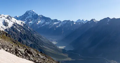
New Zealand, also called Aotearoa, is an island country in the South Pacific. Its two main islands have snowy mountains, glaciers, volcanoes and deep fiords, and about 5.36 million people lived there in 2026.
-
Watch
Animal
Green sea turtle
The green sea turtle is the largest sea turtle with a hard shell. It lives in warm seas around the world and, unlike other sea turtles, grown-ups eat mostly seagrass and algae. Females swim hundreds or even thousands of kilometers to lay their eggs on the beaches where they hatched long ago.
-
Watch
Animal
Humphead wrasse
The humphead wrasse is the biggest fish in the wrasse family, up to about 2.3 meters long. Adults have thick lips, a forehead hump and wavy lines on the face. They eat shellfish, sea urchins and even toxic crown-of-thorns starfish, and many change from female to male. Too many have been caught, so it is endangered.
-
 Watch
 Country
Tuvalu
Tuvalu is a Polynesian country of nine small coral islands strung across about 676 kilometers of the west-central Pacific. Most of the land is only 4 to 5 meters above the sea. Once called the Ellice Islands, Tuvalu became independent in 1978. Its 2022 census counted 10,643 people.
-
 Watch
 Country
New Caledonia
New Caledonia is a group of islands in the southwestern Pacific, about 1,500 kilometers east of Australia. It is part of France, with a special status and its own government. Its lagoons and reefs are a World Heritage Site, and the 2025 census counted 264,596 people.
-
 Watch
 Country
Vanuatu
Vanuatu is a Y-shaped chain of islands in the southwestern Pacific, between Fiji and Australia. It has active volcanoes, thick rainforest and coral reefs. More than 100 local languages are spoken, and people make beautiful sand drawings with one finger. Britain and France ruled the islands together until independence in 1980. The 2020 census counted 300,019 people.
For parents & teachers
What children will learn
- Locate Fiji in the South Pacific and describe how its islands formed.
- Describe how rainfall differs between the eastern and western sides of the big islands.
- Describe Fiji's communities, languages and traditional crafts.
- Outline Fiji's history from Lapita settlers to independence in 1970.
Recommended ages: 3 to 17 · About 15 minutes
Talk about it
- What would it be like to live on an island where the nearest neighbor is far across the sea?
- Why do you think most people in Fiji speak at least two languages?
- How might coral reefs protect an island's shore?
Try at home or in class
- On a map, measure how far Fiji is from New Zealand and Australia using the map's scale bar.
- Make a paper 'masi' pattern: fold brown paper, draw repeating shapes with a dark crayon, and talk about how real masi is made from bark.
Key vocabulary: archipelago, islet, masi, indentured laborer, tropical cyclone, cession
Where these facts come from
- Wikidata , Wikimedia Foundation (CC0 1.0)
- Natural Earth vector data , Natural Earth (NACIS) (Public domain)
- UNESCO World Heritage List , UNESCO World Heritage Centre (Linked as a reference; site facts come from Wikidata)
- Fiji (introduction and quick facts) , Encyclopaedia Britannica
- Fiji: Land (relief, climate, plant and animal life) , Encyclopaedia Britannica
- Fiji: People (ethnic groups, languages, settlement) , Encyclopaedia Britannica
- Fiji: Cultural life , Encyclopaedia Britannica
- Fiji: History , Encyclopaedia Britannica
- Levuka Historical Port Town , UNESCO World Heritage Centre
- Fiji's population increases to 884,887 according to last year's census , Fiji Village
- Sustainability and tradition (Fiji's Great Sea Reef) , WWF
- PlayOwl region table, version 1 , PlayOwl (PlayOwl original data)
- flag-icons 7.5.0 , Panayiotis Lipiridis and contributors (MIT)
- Wikimedia Commons , Wikimedia Foundation (Per file (public domain, CC0, CC BY or CC BY-SA); see each media record)
Checked, not yet human-reviewed. Last updated November 1, 2026. Spotted a mistake? Tell us.