
 Country
Europe
Iceland
Iceland is an island country in the cold North Atlantic Ocean. It has volcanoes, big glaciers, hot springs and puffins.
Iceland is an island country in the North Atlantic, close to the Arctic Circle. It sits on the border between two giant plates of Earth's crust and has about 200 volcanoes, many hot springs and huge glaciers, and about 396,500 people lived there in mid-2026.
Iceland is a volcanic island of about 103,000 square kilometers astride the Mid-Atlantic Ridge, the boundary between the North American and Eurasian plates. Glacier ice and young lava each cover about a tenth of it, geothermal water heats the whole capital, and Statistics Iceland counted 396,500 residents at the end of June 2026.
Photo: Jakub Hałun, CC BY-SA 4.0, via Wikimedia Commons
Discover Iceland
Iceland is a big island far out in the sea.
It is near the top of the world, and winters are dark. Some mountains are volcanoes. Hot water bubbles up out of the ground. The capital city is called Reykjavík.
Iceland is an island country in the North Atlantic Ocean. The Arctic Circle nearly touches its northern tip, and its nearest neighbor in Europe, Scotland, is about 800 kilometers away. Greenland lies about 320 kilometers to the northwest, across the Denmark Strait.
Iceland sits right on top of a long underwater mountain chain called the Mid-Atlantic Ridge, on the border between two giant plates of Earth's crust. That is why it has so many volcanoes: about 200. It also has more hot springs than any other country. Its capital is Reykjavík, and about 396,500 people lived in Iceland at the end of June 2026.
Iceland covers about 103,000 km² in the North Atlantic, roughly 800 km from Scotland and 320 km from Greenland across the Denmark Strait; its rugged coastline is more than 4,800 km long. Britannica describes it as a tableland broken by faults, with an average elevation of about 500 m, a quarter of the country below about 200 m (650 feet), and an uninhabited center.
The island lies on the Mid-Atlantic Ridge, the spreading boundary between North America and Europe. It is geologically young (its oldest rocks formed about 16 million years ago) and holds about 200 volcanoes; Britannica estimates that since 1500 about a third of Earth's total lava flow has come from Icelandic volcanoes. Statistics Iceland counted 396,500 residents at the end of the second quarter of 2026, 253,230 of them in the Capital region around Reykjavík.
Cities and famous places
Reykjavík is the biggest city in Iceland.
It is by the sea. Hot water from under the ground warms its houses. Not far away, a geyser shoots water high into the air. Big waterfalls roar over the rocks.
Reykjavík, the capital, stands where Iceland's first farm was built, more than 1,000 years ago. Its name means "Bay of Smokes." Today hot water from deep underground heats every home and building in the city. More than half of all Icelanders live in Reykjavík and the towns around it.
East of the capital, in the Geysir geothermal field, the geyser Strokkur shoots hot water into the sky. Nearby is Gullfoss, a waterfall 32 meters high. In the northeast, Dettifoss drops 44 meters, and in the south, Seljalandsfoss falls 65 meters.
Reykjavík ("Bay of Smokes") occupies the site of the island's first farmstead and is the seat of government and the national center of commerce, industry, higher education and culture; geothermal energy heats all of it. Statistics Iceland counted 253,230 people in the Capital region at the end of June 2026, close to two-thirds of the population. Akureyri, on the Eyja Fjord in the north, is the second center, a fishing and educational town.
Þingvellir (Thingvellir), east of Reykjavík, is where the Althing, an open-air assembly for all of Iceland, was founded in 930 and met until 1798; UNESCO inscribed the national park in 2004 for the assembly site, with fragments of about 50 turf-and-stone booths. Off the south coast, Surtsey, a World Heritage Site since 2008, is a new island built by eruptions from 1963 to 1967. Among its natural sights are the Strokkur geyser in the Geysir field and the waterfalls Gullfoss (32 m), Dettifoss (44 m) and Seljalandsfoss (65 m).

Fire and ice
Iceland has fire and ice.
Fire comes from volcanoes. Ice comes from giant glaciers. The biggest glacier is called Vatnajökull. In some places, hot water and steam puff out of the ground.
About one-tenth of Iceland is covered by glacier ice, and about one-tenth by cooled lava. The biggest glacier, Vatnajökull, covered about 7,500 square kilometers in 2023 and is up to about 950 meters thick. Under the ice are volcanoes. When one erupts, melted ice can burst out in a sudden flood.
Volcanoes erupt often. In 2010, ash clouds from Eyjafjallajökull disrupted air traffic across northern and central Europe for days. The highest peak, Hvannadalshnúkur, is 2,110 meters tall. The warm Gulf Stream current keeps Iceland milder than you might expect: in Reykjavík the average temperature is about −0.5 °C in January and 11 °C in July.
Glacier ice and cooled lava each cover about a tenth of Iceland. Vatnajökull, the largest ice cap, covered about 7,500 km² in 2023 and is up to about 950 m thick; Vatnajökull National Park notes that it is still Europe's largest ice cap by volume, although it lost more than 15 percent of its volume during the last century. UNESCO's Vatnajökull National Park (2019) covers over 1,400,000 ha, nearly 14 percent of Iceland, with ten central volcanoes, eight of them beneath the ice; eruptions under the glacier cause jökulhlaups, sudden floods that build wide sandur plains. On the rim of Öræfajökull's caldera, Hvannadalshnúkur rises to 2,110 m, the country's highest peak (Icelandic Met Office).
Iceland has more hot springs and solfataras than any other country: alkaline springs in about 250 areas, and 19 high-temperature fields. The climate is maritime subarctic, shaped by the Gulf Stream and the colder East Greenland Current; Reykjavík averages 4 °C over the year, and annual precipitation ranges from 410 mm on northern plateaus to more than 4,100 mm on southern ice-capped slopes. Only about a quarter of the land has continuous plant cover.

Animals of Iceland
Puffins have big, colorful beaks.
About half of all Atlantic puffins nest in Iceland. Foxes live there too. Many ducks swim on a big lake in the north. Salmon and trout swim in the rivers.
When the first settlers arrived, foxes were the only land mammals in Iceland. People later brought farm animals, and reindeer, which still live in the highlands of the northeast. There are no reptiles or amphibians at all.
Birds are everywhere. Many sea cliffs are packed with nesting birds, and about half of all Atlantic puffins in the world breed in Iceland. The Westman Islands, off the south coast, have the largest puffin colony on Earth. In the north, Lake Mývatn has the largest and most varied colony of ducks in Europe. Salmon and trout swim in the rivers, and the seas around Iceland are rich in fish.
Britannica notes that foxes were Iceland's only land mammals at the time of settlement. Settlers brought domestic animals and accidentally introduced rats and mice; reindeer were introduced later and are still found in the northeastern highlands, and American mink, imported for fur farming, became wild after 1930. Iceland has no reptiles or amphibians.
About half of all Atlantic puffins (Fratercula arctica) breed in Iceland, and the Westman Islands hold the world's largest puffin colony (Cornell Lab of Ornithology). After mink spread in the 1930s almost all mainland colonies disappeared, so most remaining colonies are on small offshore islands; in the south, warming waters have changed the supply of sandeels, causing almost complete breeding failure for more than a decade. Lake Mývatn's duck colony is the largest and most varied in Europe. Cod and capelin make up about two-thirds of the fish catch, and strict catch quotas from the late 1980s helped the cod stock recover in the late 1990s.

People, languages and food
About 396,500 people live in Iceland.
They speak Icelandic. Swimming in pools warmed by the ground is popular. Many people knit and weave with Icelandic wool. Fish and smoked lamb are traditional foods.
About 396,500 people lived in Iceland in mid-2026, and almost one in five of them were citizens of other countries. The main language is Icelandic. It grew from Old Norse, the language of the first settlers, and it has changed so little that Icelanders today can still read their old stories, called sagas, written about 800 years ago.
Icelandic cooking is built around fish, along with dishes such as smoked lamb and skyr, a dessert made from cultured skim milk, served with fresh bilberries in summer. Swimming in naturally heated pools is popular, and so are chess, horse riding and handball. Icelandic wool, knitted or woven, is a well-known craft.
Statistics Iceland counted 396,500 residents at the end of June 2026; 71,130 of them (17.9 percent) were foreign citizens. Britannica describes the settlers who came from 874 as mostly of Nordic stock from Norway, with the rest largely Celtic, from Scotland and Ireland. Their Old Norse evolved into modern Icelandic, used throughout the country; Icelanders can still read the medieval sagas, written from the late 12th to the 13th century, without difficulty. More than two-thirds of the population belongs to the Evangelical Lutheran church, and there is freedom of religion.
Cuisine centers on fish: cod, haddock and gravlax, with hangikjöt (smoked lamb) and skyr, made from cultured skim milk. Sheep and dairy farming are the main kinds of farming, and greenhouses heated by geothermal water grow vegetables. Icelanders publish more than 1,000 book titles a year, swim in naturally heated pools, play chess and team handball, and keep crafts such as knitting in Icelandic wool, which has two kinds of fiber, one fine and insulating and the other long and water-repellent.
A young country with an old assembly
People came to Iceland by boat long ago.
They came from Norway and other lands. They built farms and kept sheep. Long ago, people met outdoors to make rules. The place is called Thingvellir.
Iceland was settled more than 1,000 years ago, in the Viking Age. Old Icelandic books say the first settler to stay, Ingólfr Arnarson, came from Norway in 874 and built his farm at Reykjavík. Many more families followed over the next 60 years.
In 930 they set up the Althing, an outdoor assembly at Thingvellir where leaders met each summer to make laws and settle arguments. Later Iceland came under the kings of Norway and then Denmark. In the 1800s Icelanders asked for more say in running their country. In 1918 Iceland became a separate state, and on June 17, 1944, at Thingvellir, it became a fully independent republic.
Íslendingabók, written about 1130, dates the settlement to about 870–930; Landnámabók names Ingólfr Arnarson, from Norway, as the first permanent settler in 874, at Reykjavík, and lists more than 400 settlers. A layer of volcanic ash found with the earliest remains of habitation has been dated, in Greenland ice, to about 870. The Althing, founded in 930 at Þingvellir, met each summer to make laws and hear cases, although women and workers had no role in it. In 999 or 1000 the Althing decided peacefully that all Icelanders should become Christians.
In 1262–64 Iceland's chieftains swore allegiance to the king of Norway, and in 1380 the Norwegian crown joined with Denmark's. A restored Althing met in Reykjavík in 1845, a constitution followed in 1874 and home rule in 1904. Some 15,000 Icelanders emigrated between 1870 and 1914, most to Canada. Iceland became a separate state under the Danish crown on December 1, 1918, and a republic at Þingvellir on June 17, 1944, now National Day. Its 1944 constitution created a parliamentary democracy with a directly elected president and a 63-member Althing; in 1980 Vigdís Finnbogadóttir became the country's first woman president.

Iceland on the map
Find Iceland on the globe.
It is far out in the ocean, between Europe and Greenland. It is near the top of the world. Iceland has no land border with any other country.
Iceland is in the North Atlantic Ocean, between Greenland and Norway. Because it is an island, it shares no land border with any other country. Its coastline, cut by many deep bays called fjords, is more than 4,800 kilometers long.
The Greenland Sea lies to the north, the Norwegian Sea to the east and the Atlantic Ocean to the south and west. Greenland is about 320 kilometers away, across the Denmark Strait, and Scotland about 800 kilometers to the southeast.
Iceland lies in the North Atlantic just south of the Arctic Circle, which nearly touches its northernmost peninsula. Britannica gives its sea boundaries as the Greenland Sea to the north, the Norwegian Sea to the east, the Atlantic to the south and west, and the Denmark Strait, about 320 km wide, separating it from Greenland to the northwest. It has no land border with another country.
The coast, more than 4,800 km long, is cut by fjords where rivers do not drain glaciers; glacial erosion deepened their inner parts, giving many natural harbors, while the south coast is regular and sandy, with sandbars and lagoons. The island lies on the Mid-Atlantic Ridge, which Britannica calls the constantly active geologic border between North America and Europe. Traditionally Iceland is divided by the four points of the compass, and its interior is uninhabited.
- Coastline
- more than 4,800 km
- Distance to Greenland
- about 320 km, across the Denmark Strait
- Distance to Scotland
- about 800 km
- Highest point
- Hvannadalshnúkur, 2,110 m
Amazing facts
-
A brand-new island grew out of the sea near Iceland.
Between 1963 and 1967, eruptions under the sea built a new island called Surtsey, about 32 kilometers off Iceland's south coast.
Surtsey formed in eruptions from 1963 to 1967; protected since its birth, it has let scientists record how plants and animals colonize new land, with 89 bird species recorded there.
-
Hot water from under the ground warms homes in Reykjavík.
Geothermal energy, heat from inside the Earth, warms every home and building in Reykjavík.
Britannica notes that geothermal energy heats all of Reykjavík and several other communities, supplies industrial steam and warms commercial greenhouses.
-
About half of all Atlantic puffins nest in Iceland.
About half of the world's Atlantic puffins breed in Iceland, and the Westman Islands have the biggest puffin colony on Earth.
The Cornell Lab of Ornithology reports that Iceland holds about half of the global Atlantic puffin population and that the Westman Islands host the world's largest colony.
-
Iceland has no snakes, lizards or frogs.
There are no reptiles or amphibians in Iceland at all, so no snakes, lizards or frogs.
Britannica records no reptiles or amphibians in Iceland, and foxes as the only land mammals present when settlers arrived.
-
People in Iceland can read stories written long, long ago.
Icelandic has changed so little since Viking times that Icelanders can still read their medieval sagas without much difficulty.
Old Norse, spoken by the settlers, evolved into modern Icelandic; Britannica notes that modern Icelanders can read the sagas in Old Norse without difficulty.
Words to know
- glacier
- a huge, slow-moving mass of ice that builds up from snow over many years
- geyser
- a hot spring that shoots water and steam into the air from time to time
- geothermal energy
- heat that comes from deep inside the Earth
- fjord
- a long, narrow, deep bay between steep cliffs, carved by glaciers
- tectonic plate
- one of the giant, slowly moving pieces of Earth's outer shell
- saga
- a long story written in Iceland in the Middle Ages about families and events of the past
- World Heritage Site
- a place UNESCO lists as important to all people, to be protected
Discovery challenge
-
What is the capital city of Iceland?
Which city is the capital of Iceland?
Which city, named "Bay of Smokes", stands on the site of Iceland's first farmstead and is its capital?
- Reykjavík
- Akureyri
- Oslo
Show the answer
Reykjavík
Reykjavík is the capital. It is by the sea.
Reykjavík is the capital. Akureyri is a town in the north, and Oslo is the capital of Norway.
Reykjavík ("Bay of Smokes") is the capital and seat of government; Akureyri is the second center, in the north; Oslo is Norway's capital.
-
Iceland sits on a long line of mountains under the sea. What is it called?
Iceland sits on top of an underwater mountain chain on the border between two plates. What is it called?
Iceland's volcanoes are explained by its position on which plate boundary?
- The Himalayas
- The Mid-Atlantic Ridge
- The Andes
Show the answer
The Mid-Atlantic Ridge
It is the Mid-Atlantic Ridge. It runs under the sea.
The Mid-Atlantic Ridge runs under the Atlantic Ocean, and Iceland is on top of it. The Himalayas and the Andes are on land, far away.
Britannica explains Iceland's volcanoes by its position on top of the Mid-Atlantic Ridge, the active geologic border between North America and Europe.
-
What warms the houses in Reykjavík?
What heats every home and building in Reykjavík?
Which energy source heats all of Reykjavík?
- Hot water from under the ground
- Burning coal
- Sunshine on the roofs
Show the answer
Hot water from under the ground
Hot water comes up from under the ground and warms the houses.
Heat from deep inside the Earth, called geothermal energy, heats the whole city.
Geothermal energy heats all of Reykjavík and several other communities and warms greenhouses that grow vegetables.
-
Where do about half of all Atlantic puffins nest?
In which country do about half of the world's Atlantic puffins breed?
Which country holds about half of the global Atlantic puffin population, with the largest colony in its Westman Islands?
- Spain
- Egypt
- Iceland
Show the answer
Iceland
About half of all Atlantic puffins nest in Iceland.
About half of all Atlantic puffins breed in Iceland, and the biggest colony is in the Westman Islands.
Iceland holds about half of the global population; most of its colonies are now on small offshore islands, and the Westman Islands colony is the world's largest.
-
Long ago, where did Icelanders meet to make rules?
Where did the Althing, Iceland's outdoor assembly, first meet in 930?
At which site, now a World Heritage Site, did the Althing meet from 930 until 1798?
- Thingvellir
- Surtsey
- Vatnajökull
Show the answer
Thingvellir
They met outdoors at a place called Thingvellir.
The Althing met at Thingvellir. Surtsey is an island born in the 1960s, and Vatnajökull is a glacier.
The Althing met at Þingvellir from 930 to 1798; UNESCO inscribed the national park in 2004. Surtsey did not exist until 1963.
Places to discover in Iceland
-
Watch
Natural wonder
Eyjafjallajökull
Eyjafjallajökull is an ice cap in southern Iceland that covers a volcano. In 2010 the volcano erupted for the first time since 1821. Melting ice and hot lava made very fine ash, and winds carried it over Europe. To keep passengers safe, more than 100,000 flights were canceled in one week of April.
-
Watch
Natural wonder
Vatnajökull
Vatnajökull, in southeastern Iceland, is a huge ice cap covering about 7,500 square kilometers. It is Europe's largest ice cap by volume. Volcanoes lie hidden beneath the ice, and when they erupt, melting ice can burst out in sudden floods. The ice cap sits at the heart of Vatnajökull National Park, a World Heritage Site of "fire and ice".
Animals of Iceland
-
 Watch
3D
Animal
Atlantic puffin
The Atlantic puffin is a small seabird of the North Atlantic, often called the clown of the sea because of its huge, colorful bill. It spends most of its life far out on the ocean and comes ashore only in summer to nest in burrows on islands and cliff tops. Underwater, its small wings work like flippers.
-
 Watch
Animal
Arctic fox
The Arctic fox lives on the frozen tundra around the North Pole. Its coat changes color with the seasons, white or blue-gray in winter and brown or gray in summer, and it has short ears, a short nose and furry feet to keep the cold out. It eats lemmings, birds and leftovers from polar bears.
-
 Watch
3D
Animal
Atlantic cod
The Atlantic cod is a large, speckled fish of the cold North Atlantic. It has a whisker-like barbel on its chin and three fins along its back. For hundreds of years people have caught cod for food, so many that some cod populations crashed and are still being rebuilt today.
-
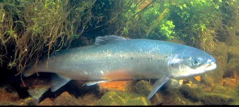 Watch
Animal
Atlantic salmon
The Atlantic salmon hatches in a river, swims out to the North Atlantic Ocean to feed and grow, then returns to the very river where it was born to lay its eggs. Along the way it changes color and shape several times.
-
 Watch
3D
Animal
Common murre
The common murre is a seabird of cold northern oceans that looks a little like a flying penguin. It dives deep to chase fish, nests in huge crowds on cliff ledges, and its chicks flutter down from the cliff to the sea before they can even fly.
-
 Watch
Animal
Greenland shark
The Greenland shark is a huge, slow-moving shark of the cold North Atlantic and Arctic Ocean. It grows very slowly in the cold, and in 2016 scientists used the lenses of its eyes to estimate that it can live for at least 272 years, longer than any other animal with a backbone that we know of.
-
 Watch
3D
Animal
Atlantic herring
The Atlantic herring is a small, silvery fish of the cold North Atlantic. Herring swim in enormous schools, eat tiny floating plankton, and lay their sticky eggs on the sea floor. Whales, seabirds and many fish depend on them for food, and people have fished for them for hundreds of years.
Explore next
-
Watch
Natural wonder
Vatnajökull
Vatnajökull, in southeastern Iceland, is a huge ice cap covering about 7,500 square kilometers. It is Europe's largest ice cap by volume. Volcanoes lie hidden beneath the ice, and when they erupt, melting ice can burst out in sudden floods. The ice cap sits at the heart of Vatnajökull National Park, a World Heritage Site of "fire and ice".
-
Watch
Natural wonder
Eyjafjallajökull
Eyjafjallajökull is an ice cap in southern Iceland that covers a volcano. In 2010 the volcano erupted for the first time since 1821. Melting ice and hot lava made very fine ash, and winds carried it over Europe. To keep passengers safe, more than 100,000 flights were canceled in one week of April.
-
Watch
3D
Animal
Atlantic puffin
The Atlantic puffin is a small seabird of the North Atlantic, often called the clown of the sea because of its huge, colorful bill. It spends most of its life far out on the ocean and comes ashore only in summer to nest in burrows on islands and cliff tops. Underwater, its small wings work like flippers.
-
Watch
Animal
Arctic fox
The Arctic fox lives on the frozen tundra around the North Pole. Its coat changes color with the seasons, white or blue-gray in winter and brown or gray in summer, and it has short ears, a short nose and furry feet to keep the cold out. It eats lemmings, birds and leftovers from polar bears.
-
Watch
3D
Animal
Atlantic cod
The Atlantic cod is a large, speckled fish of the cold North Atlantic. It has a whisker-like barbel on its chin and three fins along its back. For hundreds of years people have caught cod for food, so many that some cod populations crashed and are still being rebuilt today.
-
Watch
Animal
Atlantic salmon
The Atlantic salmon hatches in a river, swims out to the North Atlantic Ocean to feed and grow, then returns to the very river where it was born to lay its eggs. Along the way it changes color and shape several times.
-
Watch
3D
Animal
Common murre
The common murre is a seabird of cold northern oceans that looks a little like a flying penguin. It dives deep to chase fish, nests in huge crowds on cliff ledges, and its chicks flutter down from the cliff to the sea before they can even fly.
-
Watch
Animal
Greenland shark
The Greenland shark is a huge, slow-moving shark of the cold North Atlantic and Arctic Ocean. It grows very slowly in the cold, and in 2016 scientists used the lenses of its eyes to estimate that it can live for at least 272 years, longer than any other animal with a backbone that we know of.
For parents & teachers
What children will learn
- Locate Iceland in the North Atlantic and name its surrounding seas.
- Explain how sitting on the Mid-Atlantic Ridge gives Iceland its volcanoes, hot springs and geothermal heat.
- Describe some of Iceland's wildlife, language, food and ways of life without treating them as one single culture.
- Outline Iceland's history from settlement and the Althing (930) to the republic (1944).
Recommended ages: 3 to 17 · About 15 minutes
Talk about it
- How might using heat from underground change how people live, compared with places that burn fuel for heat?
- Why do you think a brand-new island like Surtsey is so useful to scientists?
- Iceland's assembly met outdoors over a thousand years ago. Where do people near you meet to make decisions?
Try at home or in class
- On a globe, find Iceland and trace the Mid-Atlantic Ridge from Iceland south toward the middle of the Atlantic.
- On a world map, measure the distances from Iceland to Greenland and to Scotland with the scale bar, and compare them with a trip you know.
Key vocabulary: glacier, geyser, geothermal energy, fjord, tectonic plate, saga, World Heritage Site
Where these facts come from
- Wikidata , Wikimedia Foundation (CC0 1.0)
- Natural Earth vector data , Natural Earth (NACIS) (Public domain)
- UNESCO World Heritage List , UNESCO World Heritage Centre (Linked as a reference; site facts come from Wikidata)
- Iceland (introduction and Land) , Encyclopaedia Britannica
- Iceland: Lakes and rivers (soils, climate, plant and animal life, people, settlement) , Encyclopaedia Britannica
- Iceland: Demographic trends (economy, resources and power) , Encyclopaedia Britannica
- Iceland: Government and society (daily life and social customs) , Encyclopaedia Britannica
- Iceland: The arts (cultural institutions, sports and recreation) , Encyclopaedia Britannica
- Iceland: History , Encyclopaedia Britannica
- Iceland: Iceland under foreign rule , Encyclopaedia Britannica
- Iceland: Modern Iceland , Encyclopaedia Britannica
- Population in the 2nd quarter 2026 , Statistics Iceland
- Vatnajökull glacier , Vatnajökull National Park (Vatnajökulsþjóðgarður)
- Öræfajökull , Icelandic Meteorological Office
- Þingvellir National Park , UNESCO World Heritage Centre
- Surtsey , UNESCO World Heritage Centre
- Vatnajökull National Park - dynamic nature of fire and ice , UNESCO World Heritage Centre
- Atlantic Puffin overview , Cornell Lab of Ornithology, All About Birds
- Atlantic Puffin life history , Cornell Lab of Ornithology, All About Birds
- PlayOwl region table, version 1 , PlayOwl (PlayOwl original data)
- flag-icons 7.5.0 , Panayiotis Lipiridis and contributors (MIT)
- Wikimedia Commons , Wikimedia Foundation (Per file (public domain, CC0, CC BY or CC BY-SA); see each media record)
Checked, not yet human-reviewed. Last updated October 24, 2026. Spotted a mistake? Tell us.
Picture credits
- Photo: Jakub Hałun, CC BY-SA 4.0, via Wikimedia Commons · source · license
- Photo: Hedwig Storch, CC BY-SA 3.0, via Wikimedia Commons · source · license
- Photo: Zairon, CC BY-SA 3.0, via Wikimedia Commons · source · license
- Photo: TommyBee, public domain, via Wikimedia Commons · source
- Photo: Andreas Tille, CC BY-SA 4.0, via Wikimedia Commons · source · license
- Photo: Chmee2/Valtameri, CC BY-SA 3.0, via Wikimedia Commons · source · license
- Photo: Spike, CC BY-SA 4.0, via Wikimedia Commons · source · license
- Photo: Zoran Kurelić Rabko, CC BY-SA 3.0, via Wikimedia Commons · source · license