
Natural wonder Europe
Rhine
The Rhine is a big river in Europe. It starts high in the Swiss mountains. It flows north past castles and cities to the sea.
The Rhine begins as two small streams high in the Swiss Alps and flows about 1,230 kilometers north and west to the North Sea, through Switzerland, Germany, France and the Netherlands. It tumbles over the Rhine Falls and winds through a gorge lined with castles. After a chemical spill in 1986, the countries along it worked together to clean it, and salmon came back.
The Rhine runs from two Alpine headstreams to the North Sea; its length, long given as 1,320 km, was revised in 2010 to about 1,230 km. Britannica calls it among the most important arteries of industrial transport in the world. Some 60 million people live in its basin across nine countries, and since the 1986 Sandoz disaster their shared commission has brought back much of the river's life, including migrating salmon.
Photo: Jörg Braukmann, CC BY-SA 4.0, via Wikimedia Commons
Discover the Rhine
The Rhine is a long river in Europe.
It starts as two little streams high in the snowy mountains of Switzerland. It flows past old castles, big cities and green vineyards. Big boats carry things up and down it. At the end, it reaches the sea.
The Rhine is one of Europe's great rivers. It starts high in the Alps of Switzerland, flows through Lake Constance and over the Rhine Falls, then runs north between France and Germany, through Germany, and out to the North Sea through the Netherlands. For a while it also forms the border between Switzerland and Liechtenstein and between Switzerland and Austria.
Its length was long given as 1,320 kilometers, but in 2010 a shorter figure of about 1,230 kilometers was proposed. The International Commission for the Protection of the Rhine says about 60 million people live in its basin, in nine countries. The name Rhine probably comes from an old Celtic word meaning great running water.
Britannica describes the Rhine as culturally and historically one of the great rivers of Europe and among the most important arteries of industrial transport in the world. It flows from two headstreams in east-central Switzerland north and west to the North Sea through the Netherlands. Its length was long given as 1,320 km; in 2010 a shorter figure of about 1,230 km was proposed. It is navigable for some 870 km, up to Rheinfelden on the Swiss-German border, and Britannica gives a catchment of more than 220,000 km² including the delta.
The International Commission for the Protection of the Rhine (ICPR) counts about 60 million people in the watershed, across nine states, and calls it the most important cultural and economic axis in Middle Europe. The ICPR also explains that the name is probably Celtic, meaning great running water, which the Romans kept as Rhenus. Below Basel the river forms the French-German border as far as the Lauter, then flows through Germany to Emmerich, below which its many-branched delta shapes the Dutch landscape.
- Length (revised 2010)
- about 1,230 km
- Source
- Two headstreams in the Swiss Alps
- Mouth
- North Sea, through a delta in the Netherlands
- People in the basin
- about 60 million, in nine countries
- Navigable
- about 870 km, up to Rheinfelden
From Alpine streams to the North Sea
The Rhine starts as two small streams in the mountains.
They join and flow into a big lake. Then the river crashes over a wide waterfall. It runs through a deep, rocky valley. At the end, it splits into many arms and reaches the sea.
The Rhine's two headstreams rise high in the Swiss Alps. The Vorderrhein flows out of Lake Toma, 2,344 meters above sea level, and joins the Hinterrhein near the city of Chur. The young river then flows into Lake Constance, where its current slows and it builds a small delta.
Leaving the lake, it pours over the Rhine Falls at Schaffhausen and runs west to Basel. There it turns north across a flat valley about 30 kilometers wide. Between Bingen and Bonn, the river has cut a deep, winding gorge between steep, slaty hills, the most famous stretch of the river. Below the German border town of Emmerich, in the Netherlands, it splits into wide branches such as the Lek and the Waal before reaching the sea.
The Vorderrhein emerges from Lake Toma at 2,344 m near the Oberalp Pass and is joined by the Hinterrhein at Reichenau above Chur. The Alpine Rhine, with a steep gradient and a typical Alpine regime of winter lows and spring and early-summer highs, builds a delta where it enters Lake Constance; that flat-floored stretch has been straightened and its banks reinforced. Below the lake, the High Rhine passes the Rhine Falls, entirely in Swiss territory, and receives the Aare, which on average carries more water than the Rhine itself. The ICPR notes the river kept the name Rhine because its course to the confluence is longer.
Below Basel the river crosses a flat-floored valley some 20 miles (about 30 km) wide between the Vosges and Black Forest; until straightening began in the early 19th century it looped across its floodplain in great meanders, whose cutoffs survive near Breisach and Karlsruhe. The middle Rhine has cut a deep, winding gorge 145 km long between the slate-covered Hunsrück and Taunus. Below Bonn the valley opens into a plain, and below Emmerich the delta branches into the Lek, Waal and Merwede. Since the Delta Project was completed in 1986, all main branches are closed off and water reaches the sea through sluices and side channels.

The salmon come back
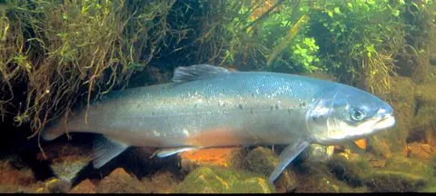
Long ago, salmon swam up the Rhine from the sea.
Then the river got dirty, and dams blocked the way. People worked hard to clean the water. Now some salmon are swimming back up the Rhine!
Salmon live most of their lives in the sea but swim back up rivers to lay their eggs, following the smell of their home water. Once, the Rhine had no obstacles from the North Sea all the way up to the Rhine Falls, so salmon could swim into streams in the Alps and the Black Forest.
Then weirs, dams and pollution cut the salmon off from their old spawning streams. In 1986 a fire at a chemical warehouse near Basel poured pesticides into the Rhine, turned it red and killed huge numbers of fish. After that, the countries along the river worked together to clean it. Since 1990, salmon have been swimming back up from the North Sea, and since 1994 they have laid eggs naturally in the Sieg, a tributary.
The ICPR explains the life cycles that make the Rhine a migratory-fish river. Salmon grow in the sea and return to spawn, guided by the smell of their home waters (homing); most make the exhausting journey only once. European eels do the reverse: they grow in rivers and return to spawn in the Sargasso Sea; their larvae reach Europe's coasts after about three years, and females mature after 12 to 15 years. Naturally, the Rhine was free of obstacles from the North Sea to the Rhine Falls.
River training, weirs and hydropower plants on the Upper Rhine and its tributaries, and the Haringvliet sluices in the delta, broke this continuity. On 1 November 1986 a fire at the Sandoz site in Schweizerhalle near Basel released some 20 to 30 tons of pesticides and other chemicals (Britannica's figure), causing mass fish deaths. The Rhine Action Programme and Salmon 2000 followed: salmon have migrated upstream since 1990 and reproduced naturally in the Sieg since 1994, the first large fish pass on an Upper Rhine barrage opened at Iffezheim in 2000, and the old Rhine's fish fauna was almost complete again at 63 species, only the sturgeon missing. In 2020 the Rhine ministers adopted Rhine 2040 and confirmed the aim of restoring continuity up to the Rhine Falls.
A river of trade and castles
People have used the Rhine for a very long time.
Long ago, the Romans sailed boats on it. People built castles on the hills beside it. Today long barges carry coal, oil and other goods.
The Romans called the river Rhenus and kept a fleet of boats on it. Ever since, the Rhine has been one of Europe's main transport routes. Castles and old towns line its banks. UNESCO protects 65 kilometers of the Upper Middle Rhine Valley, with its castles, old towns and vineyards.
For a long time, about 200 toll stations charged boats along the river. In 1815 the Congress of Vienna agreed that boats could travel the Rhine freely. Before the mid-1800s, barges going upstream were pulled by horses or teams of men; then steam tugs took over. Today Britannica says one-fifth of the world's chemical industry is located along the Rhine.
Julius Caesar bridged the Rhine in 55 and 53 BCE, and for a time it marked the edge of Roman Gaul; the Romans maintained a Rhine fleet. Britannica presents the Rhine as a classic example of a river alternating between uniting regions and dividing them as a border, a role it played for centuries. After World War II, Britannica writes, the struggle over the river gave way to a trend toward economic and even political union of the countries along it.
Trade revived in the 19th century: the Congress of Vienna (1815) agreed on free navigation, removing some 200 toll stations, and the Mainz Convention of 1831 put it into effect and created the Central Commission of the Rhine; the Mannheim Convention of 1868 broadly remains in force. Channels were blasted through the rock barrier at Bingen in 1830 to 1832, and the upper Rhine was straightened from 1817 to 1874. Steam and later diesel tugs replaced horses and men, push tugs came after 1945, and radar in the 1950s allowed round-the-clock traffic. Cheap water transport helped make the river a major axis of industry; Britannica reports one-fifth of the world's chemical industries along it. UNESCO inscribed the 65 km Upper Middle Rhine Valley in 2002.

Visiting safely
The Rhine is big, fast and busy with boats.
Stay close to a grown-up near the water. Wear a life jacket in a boat. Floating toys do not keep you safe.
The Rhine is a busy working river, with long barges and passenger boats, and its current can be strong. If you take a boat trip, wear a life jacket: the US Centers for Disease Control and Prevention (CDC) says life jackets reduce drowning risk for boaters of every age and swimming ability. On the riverbank, children should stay with a grown-up who keeps watching them, and a pool float is not a life jacket.
The river's level also changes. The ICPR reports that climate change is already bringing more frequent and stronger periods of high and low water on the Rhine, and it publishes a Rhine Atlas that maps the areas that can flood, from the Alps to the North Sea.
On a river this busy, the CDC's general drowning-prevention points matter: natural waters have hidden hazards, currents among them; life jackets lower the risk of drowning while boating regardless of age or swimming ability; children in or near natural water should wear one and be supervised closely and constantly, even after lessons; and inflatable or foam toys do not keep anyone afloat safely.
Britannica describes the upper Rhine's swift current and seasonal variations in flow, and the Rhine as unrivaled among rivers in the amount of traffic it carries, with tug-and-barge convoys running day and night since radar arrived in the 1950s. The ICPR's Rhine 2040 programme reports that climate change is already visible in more frequent and pronounced high- and low-water phases and in warmer water, aims to reduce flood risk under the EU Floods Directive, and publishes a Rhine Atlas of flood-prone areas from the Alps to the North Sea.
Amazing facts
-
The name Rhine may mean great running water.
The name Rhine probably comes from an old Celtic word meaning great running water. The Romans called it the Rhenus.
The ICPR notes the name is of Celtic origin, meaning great running water, a meaning the Romans kept in Rhenus.
-
Another river brings more water to the Rhine than the Rhine has.
Where the Aare River joins the Rhine, the Aare usually carries more water. The Rhine keeps its name because its course up to that point is longer.
At the confluence the Aare usually carries the larger volume, normally the deciding factor in naming, but the Rhine's longer course won out.
-
Long ago, horses pulled boats up the Rhine.
Before the mid-1800s, barges going up the Rhine were pulled by teams of horses or groups of men walking along the bank.
Before the mid-19th century, upstream barges were towed by horse teams or gangs of men; steam, and later diesel, tugs replaced them.
-
Eels from the Rhine swim far across the ocean.
European eels grow up in the Rhine, then swim to the Sargasso Sea, in the Atlantic Ocean south of Bermuda, to lay their eggs.
Eels spawn in the Sargasso Sea; their larvae take about three years to reach European coasts, where they become glass eels and swarm upstream.
Words to know
- headstream
- a stream that forms the start of a river
- gorge
- a deep, narrow valley with steep sides, often cut by a river
- delta
- low, flat land where a river splits into branches near the sea, built from the sediment it carries
- barge
- a long, flat boat for carrying heavy goods on rivers and canals
- migration
- a long journey animals make, often to find food or a place to have young
- fish pass
- a set of steps or channels that lets fish swim around a dam
- pollution
- harmful things put into water, air or land
Discovery challenge
-
Where does the Rhine start?
In which mountains does the Rhine begin?
In which mountains do the Vorderrhein and Hinterrhein rise?
- The Swiss Alps
- The Pyrenees
- The Carpathians
Show the answer
The Swiss Alps
High in the Swiss Alps, as two little streams.
Its two headstreams rise in the Swiss Alps and join near Chur.
In the Swiss Alps: the Vorderrhein from Lake Toma at 2,344 m, joined by the Hinterrhein at Reichenau.
-
Which sea does the Rhine flow into?
Into which sea does the Rhine empty?
Into which sea does the Rhine drain through the Netherlands?
- The Black Sea
- The North Sea
- The Mediterranean Sea
Show the answer
The North Sea
The North Sea, past the Netherlands.
The Rhine reaches the North Sea through its delta in the Netherlands.
The North Sea; since 1986 its main delta branches are closed off and the water reaches the sea through sluices.
-
Which fish is swimming back up the Rhine?
Which fish has been swimming back up the Rhine from the North Sea since 1990?
Which migratory fish has reproduced naturally in the Rhine's tributary the Sieg since 1994?
- Salmon
- Shark
- Goldfish
Show the answer
Salmon
The salmon! It swims up from the sea.
Salmon have been migrating up the Rhine since 1990 after the river was cleaned up.
Salmon, migrating since 1990 and spawning naturally in the Sieg since 1994.
-
What made the Rhine very dirty in 1986?
What happened near Basel in 1986 that badly polluted the Rhine?
What event of 1 November 1986 spurred the Rhine countries' joint clean-up?
- A fire at a chemical factory
- A volcano erupting
- A big snowstorm
Show the answer
A fire at a chemical factory
A fire at a chemical factory. Now the water is much cleaner.
A fire at a chemical warehouse near Basel poured pesticides into the river and killed many fish.
The Sandoz fire at Schweizerhalle, which released some 20 to 30 tons of pesticides and other chemicals.
-
What is happening more often on the Rhine as the climate warms?
According to the ICPR, what is climate change already bringing to the Rhine?
What effect of climate change does the ICPR's Rhine 2040 programme say is already evident on the river?
- More times of very high and very low water
- The river freezing all summer
- The river flowing backward
Show the answer
More times of very high and very low water
Sometimes the river gets very full, and sometimes very low.
The ICPR reports more frequent and stronger periods of high and low water, and warmer water.
More frequent and pronounced high- and low-water phases and higher water and air temperatures, affecting plants and animals.
Nearby places
-
 Watch
Natural wonder
Alps
The Alps are Europe's great mountain range, an arc about 1,200 kilometers long that runs from the Mediterranean coast near Nice, in France, to Vienna, in Austria. Their highest peak is Mont Blanc, which Britannica gives as 4,807 meters. The Alps rose when the plate carrying Africa pushed north into Europe, and Ice Age glaciers carved their sharp peaks and deep valleys.
-
 Watch
Natural wonder
Matterhorn
The Matterhorn is a 4,478-meter mountain in the Alps, on the border between Switzerland and Italy. Its rock was pushed up when Africa moved toward Europe, and glaciers later carved its steep sides into a pyramid shape. Climbers first reached its top on 14 July 1865.
-
 Watch
Landmark
Milan Cathedral
Milan Cathedral, called the Duomo, is a giant Gothic cathedral made of pink-and-white marble. Building began in 1386, and the last details of its front were finished only in 1965. It has more statues than any other building in the world, over 3,000 of them.
-
 Watch
Natural wonder
Mont Blanc
Mont Blanc is the highest peak in the Alps, on the border of France and Italy. Its snowy top changes height a little from year to year: in September 2026, French surveyors measured it at 4,807.47 meters. People first climbed it in 1786, and today a long tunnel runs right underneath it.
-
 Watch
Natural wonder
Danube
The Danube is Europe's second-longest river, after the Volga. It begins as two small streams in Germany's Black Forest and flows about 2,850 kilometers east to the Black Sea, passing through 10 countries and four capital cities. For more than 2,000 years it has been a border, a highway for boats and a home for wildlife, and it ends in a giant delta of reeds, lakes and birds.
-
 Watch
Landmark
Neuschwanstein Castle
Neuschwanstein Castle stands on a rocky ridge in Bavaria, Germany. King Ludwig II had it built from 1869 as a private retreat in the style of a medieval knights' castle, but with the newest technology inside. It opened to visitors in 1886, and in 2025 about 1.1 million people came.
-
 Watch
City
Munich
Munich is the capital of Bavaria, a state in southern Germany, and the country's third-biggest city. It began in 1158 as a market by a bridge over the Isar River, and its name means "Home of the Monks." Today it is famous for its palaces, art museums, the huge Deutsches Museum and its autumn Oktoberfest.
-
 Watch
City
Venice
Venice, in northern Italy, is spread over 118 small islands in a shallow lagoon off the Adriatic Sea. There are no cars in the old city: people walk or travel by boat along its canals, past palaces and over about 400 bridges. High tides sometimes flood its squares, so giant gates now protect the lagoon.
Experiments to try
Explore next
-
 Watch
 Country
Switzerland
Switzerland is a small, landlocked country in central Europe. The Alps cover its south and east, great rivers such as the Rhine and Rhône begin there, and its 9.1 million people share four national languages: German, French, Italian and Romansh.
-
Watch
 Country
Germany
Germany is a country in north-central Europe. The land rises from flat plains by the North Sea and the Baltic Sea to forested hills and, in the far south, the Alps. About 83.5 million people (2025) live there, and its capital is Berlin.
-
 Watch
 Country
France
France is a country in northwestern Europe, between the Atlantic Ocean and the Mediterranean Sea. It has high mountains such as the Alps and the Pyrenees, long rivers such as the Loire and the Seine, and about 69.1 million people (2026). Its capital is Paris.
-
 Watch
 Country
Netherlands
The Netherlands is a small, flat country in northwestern Europe on the North Sea. Its name means low-lying country: more than a quarter of it lies below sea level, protected by dunes and dikes. About 18.2 million people lived there in 2026, and its capital is Amsterdam, a city of canals.
-
 Watch
 Country
Austria
Austria is a landlocked country in central Europe. The Alps cover much of it, the Danube River flows across the north, and about 9.2 million people live there. Its capital, Vienna, is famous for its music and palaces.
-
 Watch
 Country
Liechtenstein
Liechtenstein is one of the smallest countries in Europe, tucked between Switzerland and Austria. Its west is the flat valley of the Rhine River, and its east is steep Alpine mountains. About 41,000 people live there, and its head of state is a prince.
-
Watch
Natural wonder
Alps
The Alps are Europe's great mountain range, an arc about 1,200 kilometers long that runs from the Mediterranean coast near Nice, in France, to Vienna, in Austria. Their highest peak is Mont Blanc, which Britannica gives as 4,807 meters. The Alps rose when the plate carrying Africa pushed north into Europe, and Ice Age glaciers carved their sharp peaks and deep valleys.
-
Watch
Natural wonder
Danube
The Danube is Europe's second-longest river, after the Volga. It begins as two small streams in Germany's Black Forest and flows about 2,850 kilometers east to the Black Sea, passing through 10 countries and four capital cities. For more than 2,000 years it has been a border, a highway for boats and a home for wildlife, and it ends in a giant delta of reeds, lakes and birds.
For parents & teachers
What children will learn
- Trace the Rhine from the Swiss Alps to the North Sea and name the countries it crosses or borders.
- Describe how a river changes from a mountain stream to a gorge and a delta.
- Explain how agreements on free navigation and shared protection shaped the Rhine.
- Describe how a polluted river was cleaned up so that salmon could return.
Recommended ages: 3 to 17 · About 15 minutes
Talk about it
- A chemical spill in one country harmed the river in others. Why do neighbors need to agree on rules for a shared river?
- Dams make electricity and help boats, but block fish. What could people build to help both?
- Why do you think so many castles were built on the hills above the Rhine?
Try at home or in class
- Make a fish pass: stack plastic cups in steps in a tray, pour water from the top and watch how it flows down step by step.
- Put a few drops of food coloring in a jar of water to see how quickly a small spill spreads through a whole river.
Key vocabulary: headstream, gorge, delta, barge, migration, fish pass, pollution
Where these facts come from
- Wikidata , Wikimedia Foundation (CC0 1.0)
- Natural Earth vector data , Natural Earth (NACIS) (Public domain)
- Rhine River , Encyclopaedia Britannica
- Rhine River: Hydrology (regime, navigation, traffic) , Encyclopaedia Britannica
- Rhine River: History , Encyclopaedia Britannica
- The Rhine , International Commission for the Protection of the Rhine (ICPR)
- Salmon 2020 , International Commission for the Protection of the Rhine (ICPR)
- Migratory fish , International Commission for the Protection of the Rhine (ICPR)
- Rhine 2040 , International Commission for the Protection of the Rhine (ICPR)
- ICPR home (Sandoz anniversary, Rhine Atlas) , International Commission for the Protection of the Rhine (ICPR)
- Upper Middle Rhine Valley , UNESCO World Heritage Centre
- Preventing Drowning , US Centers for Disease Control and Prevention
- Wikimedia Commons , Wikimedia Foundation (Per file (public domain, CC0, CC BY or CC BY-SA); see each media record)
Checked, not yet human-reviewed. Last updated October 27, 2026. Spotted a mistake? Tell us.
Picture credits
- Photo: Jörg Braukmann, CC BY-SA 4.0, via Wikimedia Commons · source · license
- Photo: Christian David, CC BY-SA 4.0, via Wikimedia Commons · source · license
- Photo: Hartley, William W., public domain, via Wikimedia Commons · source
- Photo: Thomas Wolf, CC BY-SA 3.0 DE, via Wikimedia Commons · source · license
- Photo: mr_capgras, CC BY 4.0, via Wikimedia Commons · source · license