City Europe
Amsterdam
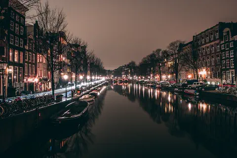
Amsterdam is the capital city of the Netherlands. Canals full of boats run between its tall, narrow houses. Lots of people ride bikes.
Amsterdam is the capital of the Netherlands. It began as a fishing village beside a dam on the Amstel River, which gave the city its name. Today about 942,000 people live among its rings of canals, hundreds of bridges, houseboats and bicycles.
Amsterdam, first named in 1275 and chartered in 1306, grew from a dam on the Amstel into the financial and trading center of the 17th-century world. Its canal ring is a UNESCO World Heritage Site (2010). It is the constitutional capital, though the government sits in The Hague; it had 941,927 residents in 2026.
Photo: GillyBerlin, CC BY 2.0, via Wikimedia Commons
Discover Amsterdam
Amsterdam is the capital city of the Netherlands.
Canals run all through the city, like streets made of water. Boats float along them, and some people live on houseboats. Tall, narrow houses stand side by side.
Amsterdam is the capital of the Netherlands, a low, flat country beside the North Sea. About 942,000 people lived there in 2026. The government, though, meets in another city, The Hague.
The city is famous for its canals. They divide the old center into about 90 islands, and the city has about 1,300 bridges. Hundreds of houseboats line the canals. Parts of Amsterdam are below sea level, on land won from the sea, marshes and lakes, so dikes and dams are very important here.
Amsterdam lies in flat, low-lying land, mainly on the south bank of the IJ, an inland arm of the former Zuiderzee (now the IJsselmeer), linked by canal to the North Sea. The Amstel River flows north through the city to the IJ. Parts of the city are below sea level, some on land reclaimed from the sea or from marshes and lakes. The city covers 165 km² and had 941,927 residents in 2026 (Statistics Netherlands).
Amsterdam is the nominal capital and the country's commercial and financial center, but the seat of government is The Hague, and the royal family only occasionally stays at the Royal Palace on the Dam. Britannica notes that the city lacks monumental architecture: no grand parade squares or triumphal arches, but narrow, busy streets, gabled houses and some 90 canal-bound islands crossed by about 1,300 bridges and viaducts.
- Country
- Netherlands (capital; government in The Hague)
- People (2026)
- 941,927
- Area of the city
- 165 km²
- Bridges and viaducts
- about 1,300
Famous places
Amsterdam has three big canals that curve around the old city.
Beside them stand tall old houses with pointed tops. The Royal Palace is on a big square called the Dam. The Rijksmuseum is full of famous paintings.
Three great canals, the Herengracht, Keizersgracht and Prinsengracht, curve around the old center like rings in a spiderweb. They were dug in the 1600s and are lined with fine old merchants' houses. In 2010 UNESCO made the canal ring a World Heritage Site.
On the Dam, the main square, stands the Royal Palace, built as the city hall in the 1600s. Rembrandt is buried in the West Church, and his house is now a museum. The Rijksmuseum, built from 1876 to 1885, holds great Dutch art. Central Station stands on an artificial island, and at Prinsengracht 263 is the hiding place of Anne Frank.
The Herengracht, Keizersgracht and Prinsengracht, laid out under the Three Canals Plan of 1612 outside the old Singel, form with smaller radial canals a spiderweb pattern extended east along the harbor and west into the Jordaan during the Golden Age; UNESCO inscribed the Seventeenth-Century Canal Ring Area inside the Singelgracht in 2010. The old town keeps the Old Church (13th century), the New Church (begun in the 15th century) and, beside it, Jacob van Campen's 17th-century city hall in classical Palladian style, now the Royal Palace.
Other landmarks include the Mint Tower, the South Church (1611), the West Church (1631), where Rembrandt is buried, the Portuguese Synagogue (1671) and the Rembrandt House in the former Jewish quarter. The building boom of the late 19th century added the Rijksmuseum (1876–85), Central Station (1889), on an artificial island in the IJ, the Concertgebouw (1888) and the Stedelijk Museum (1895). In 1942 Anne Frank's family went into hiding in the annex at Prinsengracht 263, where she kept her diary until they were arrested on August 4, 1944.
- Canal ring
- UNESCO World Heritage Site, 2010
- Rijksmuseum
- built 1876–85
- Central Station
- built 1889 on an artificial island
- Anne Frank's hiding place
- Prinsengracht 263
From fishing village to world trading city
Long ago, fishermen lived beside the Amstel River.
They built a dam across the river to keep out floods. The town was named after the dam: Amsterdam. Later it grew rich from ships that sailed around the world.
Amsterdam began in the 1200s as a small fishing village. To keep out floods, people built dikes along the Amstel River and, about 1270, a dam between them. The town took its name from the Amstel dam, and the name Amsterdam was first written down in 1275.
In the 1600s, the Dutch Golden Age, Amsterdam became the trading, banking and cultural center of the world. Merchants built grand houses along new canals. Later, the city's trade slowed, but it grew again in the 1800s. During World War II, German forces occupied the city, and its Jewish people were taken away by the Nazis.
No Roman settlement has been found at the mouth of the Amstel. Amsterdam began as a 13th-century fishing village; its inhabitants built dikes and, about 1270, a dam. In 1275 Count Floris V of Holland granted the "people living near the Amstel dam" a toll privilege, the first written mention of the name; a full charter followed in 1306. In 1578 the city joined the Dutch revolt against Spain, and after Spanish troops took Antwerp in 1585, Protestant refugees and Jews expelled from Portugal brought new trade and skills. The Three Canals Plan of 1612 and a new city hall followed, and by the end of the Eighty Years' War in 1648 Amsterdam was the financial, trading and cultural center of the world.
In the 18th century London and Hamburg overtook it, and Napoleon's embargo nearly stopped its trade. Prosperity returned with the East Indies trade from the 1830s; the North Sea Canal (completed 1876) gave the port a direct sea link, and the population doubled to 500,000 by 1900. The German army occupied the Netherlands in 1940, and the city's severest loss was the deportation of its Jewish inhabitants, whom Britannica counts at 70,000; the Jews and their old quarter were almost entirely destroyed. Postwar decades brought new suburbs, the metro and renewal of the inner city.
Getting around Amsterdam
In Amsterdam, lots of people ride bicycles.
Trams roll through the old streets. Boats glide along the canals. A fast train goes to the big airport.
Bicycles are everywhere in Amsterdam: about one in five workers rides a bike to work. In the old center, trams are the main way to get around, and buses serve the outer districts. A metro line opened in 1976.
Since the 1960s, city planners have tried to cut down on car traffic by improving public transportation. Fast trains connect Amsterdam with Schiphol Airport, one of the busiest airports in Europe, and boats still use the canals and the busy harbor on the IJ.
Britannica notes that, although Amsterdam has a modern metro, about one-fifth of the workforce still relies on the bicycle. Since the 1960s planners have favored public transport to reduce car use: a high-speed metro line opened in 1976 and a fast rail link to Schiphol in 1988, but trams remain the principal transport in inner Amsterdam, with buses important in the outer districts.
Schiphol is among Europe's busiest airports and a major world hub. The seaport ranks among Europe's important ones, though overshadowed by nearby Rotterdam-Europoort, its traffic declined in the late 20th century. Superhighways link the city with the rest of the Netherlands, Germany and Belgium. Central Station, built in 1889 on an artificial island in the IJ, remains the rail hub, and the North Sea Canal, completed in 1876, carries ships west to the sea.
- People who cycle to work
- about one-fifth of workers
- Metro
- high-speed line opened 1976
- Fast rail link to Schiphol Airport
- 1988
Weather and seasons
Amsterdam's weather is mild and often cloudy.
Winters are cool, not very cold. Summers are gentle, not too hot. It rains in every season, so a raincoat is handy!
The Netherlands has a temperate climate, with gentle winters, cool summers and rain in every season. In July temperatures average about 17 °C, and in January about 2 °C. About 790 millimeters of rain fall in a year.
The weather changes often, because warm air from the south and cold air from the north meet over this flat land. Winds blow strongly with nothing to stop them, and there are only about 25 clear days a year. Heavy clouds are so typical that Dutch painters made them famous.
Britannica describes the Dutch climate as temperate, with gentle winters, cool summers and rainfall in every season; westerly and southerly winds prevail, and the sea and the Gulf Stream moderate temperatures. Lying between the Azores high and the Icelandic low, the country is a meeting ground of warm and polar air, so the weather is unsettled. Frost occurs on about 60 days a year; July averages about 17 °C and January about 2 °C; annual rainfall is about 790 mm, highest in August and autumn and lowest in spring, and there are only about 25 clear days a year.
For Amsterdam, water is the constant theme. The city sits on low land beside the IJ, and parts lie below sea level, so its founders built dikes and the Amstel dam to keep out floods. Canals dug in the 17th century still drain and frame the old city.
- July average in the Netherlands
- about 17 °C
- January average in the Netherlands
- about 2 °C
- Rain in a year
- about 790 mm
Living in Amsterdam
People in Amsterdam come from many places.
Some families have lived there a long time. Others came from countries far away. You can eat Indonesian, Chinese and many other foods. Many people live in apartments by the canals.
Amsterdam has welcomed newcomers for more than 400 years. About half of the people are of Dutch background, and many families came from places such as Suriname, Indonesia, Morocco and Turkey. The city is known for its many Indonesian and Chinese restaurants.
Most people work in services such as business, banking, health care and tourism. Amsterdam has famous museums, the Concertgebouw concert hall and the University of Amsterdam. With no high-rise buildings or big highways in its center, the city keeps what Britannica calls a human scale.
Britannica calls Amsterdam small compared with most capitals: after World War II it had more than 800,000 people; numbers fell until the mid-1980s and have generally risen since, through natural increase and immigration. About half the residents are of Dutch origin, about one-tenth of Surinamese origin, with large Moroccan and Turkish minorities; the city has received immigrants since the 16th century, more recently from the former Dutch empire, as guest workers, as employees of international firms and as asylum seekers.
Only about one-tenth of the workforce is in manufacturing. Trade and transport provide about one-fifth of jobs, banking and insurance about one-eighth, health, cultural and social services about one-sixth, and tourism about one-tenth. All the major Dutch banks are headquartered here. Britannica attributes the city's appeal to business to its accessibility, culture and human scale, the result of an absence of high-rise buildings and multilane highways.
Amsterdam on the map
Find Amsterdam on the globe.
It is in the Netherlands, in Europe. The land there is very flat and low. The North Sea is not far away.
Amsterdam is in the western Netherlands, in northwestern Europe. It sits on very flat, low land, mostly on the south bank of the IJ, a waterway that is linked to the North Sea by a canal. The Amstel River flows north through the city into the IJ.
Seen from above, the old center looks like a spiderweb: rings of canals curve around the Dam, crossed by smaller canals running outward.
Amsterdam lies at about 52.4° N and 4.9° E, in the western Netherlands, mainly on the south bank of the IJ, an inland arm of the former Zuiderzee (now the IJsselmeer), connected with the North Sea by the North Sea Canal, completed in 1876. The Amstel flows from south to north through the city toward the IJ.
The medieval town grew on dikes where the Amstel met the IJ and by the 16th century was a walled city centered on the Dam, bounded roughly by the Singel and Kloveniersburgwal. Outside it, the concentric 17th-century canals and smaller radial canals form the spiderweb plan, later extended east along the harbor and west into the Jordaan; De Pijp to the south and the garden suburbs beyond came in the 19th and 20th centuries.
- Latitude
- about 52.4° north
- Longitude
- about 4.9° east
- Islands in the inner city
- about 90
- North Sea Canal
- completed 1876
Amazing facts
-
Amsterdam is named after a dam on a river.
Amsterdam takes its name from a dam built on the Amstel River in the 1200s.
The name comes from the dam on the Amstel; a toll privilege of 1275 for the "people living near the Amstel dam" is its first written record.
-
Amsterdam has about 1,300 bridges.
The canals divide the old center into about 90 islands, and the city has about 1,300 bridges and viaducts.
Canals split the inner city into some 90 islands, and the municipality has approximately 1,300 bridges and viaducts.
-
The big train station stands on an island.
Amsterdam's Central Station was built in 1889 on an artificial island in the IJ.
Central Station, the city's rail hub, was built in 1889 on an artificial island in the IJ north of the center.
-
The Royal Palace was first built as a city hall.
The Royal Palace on the Dam was built in the 1600s as Amsterdam's city hall.
Jacob van Campen's 17th-century city hall on the Dam, in classical Palladian style, is now the Royal Palace.
-
A girl named Anne Frank wrote a famous diary while hiding in Amsterdam.
During World War II, Anne Frank and her family hid for two years in an annex at Prinsengracht 263, where she wrote her diary.
Anne Frank's family hid from July 1942 in the annex of her father's business at Prinsengracht 263; they were discovered and arrested on August 4, 1944.
Words to know
- canal
- a waterway dug by people for boats or to carry water
- dam
- a wall built across a river to hold back water
- dike
- a long wall of earth that keeps the sea or a river from flooding land
- houseboat
- a boat that people live on as their home
- reclaimed land
- land made by draining water from the sea, a lake or a marsh
- capital
- the city named as a country's chief city, often where the government meets
- Golden Age
- the 1600s, when the Dutch Republic was rich and powerful in trade and art
Discovery challenge
-
Amsterdam is named after something on a river. What is it?
Amsterdam gets its name from what kind of structure on the Amstel River?
The 1275 toll privilege for 'people living near the Amstel ...' names which structure?
- A dam
- A bridge
- A castle
Show the answer
A dam
A dam! It held back the river's floods.
A dam, built about 1270 between the dikes on the Amstel.
The Amstel dam; the 1275 privilege is the first written mention of the name.
-
What runs through Amsterdam, like streets made of water?
What divides Amsterdam's old center into about 90 islands?
What did the Three Canals Plan of 1612 add around the old city?
- Canals
- Mountains
- Railways
Show the answer
Canals
Canals! Boats float along them.
Canals. The city has about 1,300 bridges to cross them.
The concentric Herengracht, Keizersgracht and Prinsengracht, inscribed by UNESCO in 2010.
-
How do many people in Amsterdam get to work?
About one in five workers in Amsterdam travels to work how?
About one-fifth of Amsterdam's workforce relies on which form of transport?
- By bicycle
- By camel
- By helicopter
Show the answer
By bicycle
By bicycle! Bikes are everywhere.
By bicycle. Trams are the main public transport in the old center.
The bicycle, even though the city has a metro (1976) and trams.
-
Where does the Dutch government meet?
Amsterdam is the capital, but in which city does the Dutch government meet?
Which city is the seat of government of the Netherlands, though Amsterdam is the capital?
- The Hague
- Rotterdam
- Amsterdam
Show the answer
The Hague
The Hague! It is another Dutch city.
The Hague. Amsterdam is the capital, but the government sits in The Hague.
The Hague; the royal family only occasionally uses the Royal Palace on the Dam.
-
Is a lot of Amsterdam's land high or low?
Parts of Amsterdam lie where, compared with the sea?
Some parts of Amsterdam, on land reclaimed from the sea, marshes or lakes, lie where relative to sea level?
- Below sea level
- High on a mountain
- Inside a volcano
Show the answer
Below sea level
Low! Some of it is lower than the sea.
Below sea level, so dikes and dams keep the water out.
Below sea level; the city's founders built dikes and the Amstel dam against floods.
Nearby places
-
 Watch
City
Brussels
Brussels is the capital of Belgium. It began as a market where a road crossed the small Senne River, and its old name means "settlement in the marshes." Its Grand-Place, ringed by 17th-century guildhalls, is a UNESCO World Heritage Site, and the city is home to many offices of the European Union.
-
 Watch
Landmark
Tower of London
The Tower of London is a castle on the River Thames, begun by William the Conqueror after 1066. Its great stone keep, the White Tower, is more than 900 years old. Over the centuries the Tower has been a royal palace, a fortress, a prison, a zoo, a mint for coins and a store for records, and today it guards the Crown Jewels.
-
 Watch
Landmark
Tower Bridge
Tower Bridge crosses the River Thames in London, beside the Tower of London. Built from 1886 to 1894, it has two stone-covered towers joined by high walkways, and a road that splits in the middle and swings up like two giant seesaws to let tall ships pass. It still opens about 850 times a year.
-
 Watch
Landmark
London Bridge
London Bridge crosses the River Thames between the City of London and Southwark. Today's bridge, made of concrete, opened in 1973, but bridges have stood here for almost 2,000 years. The stone bridge before it was sold and rebuilt in Arizona, in the United States!
-
 Watch
Landmark
British Museum
The British Museum in London was founded in 1753 and opened in 1759. It holds treasures from all over the world, like the Rosetta Stone, which helped people learn to read Egyptian hieroglyphs. Its grand building with columns was built from 1823 to 1847, and in 2025 it had more than 6.4 million visits.
-
 Watch
City
London
London, the capital of the United Kingdom, began as a Roman town almost 2,000 years ago. About 8.8 million people lived in Greater London in 2021. It has the Tower of London, Big Ben, Tower Bridge and the Tube, an underground railway that opened in 1863.
-
 Watch
Landmark
London Eye
The London Eye is a huge observation wheel, 135 meters tall, on the South Bank of the River Thames in London. It was built for the year 2000, the new millennium. Its 32 glass capsules carry up to 25 people each, and the wheel turns so slowly that people step on while it moves.
-
 Watch
Landmark
Big Ben
Big Ben is the nickname of the Great Bell inside the clock tower of the Houses of Parliament in London. The tower, 96 meters tall, was begun in 1843, and its clock started keeping time in 1859. Since 2012 the tower has been called the Elizabeth Tower.
Explore next
-
 Watch
 Country
Netherlands
The Netherlands is a small, flat country in northwestern Europe on the North Sea. Its name means low-lying country: more than a quarter of it lies below sea level, protected by dunes and dikes. About 18.2 million people lived there in 2026, and its capital is Amsterdam, a city of canals.
-
Watch
Life around the world
Getting around Amsterdam by bicycle
Amsterdam, the capital of the Netherlands, is flat and crossed by canals. In 2017, about 35 out of every 100 weekday trips made by people who live there were by bicycle, more than by car, bus, tram or metro. The city has added thousands of bike parking places, including a garage under the water by Central Station.
-
 Watch
Life around the world
Water buses of Venice, Italy
Venice is spread over 118 small islands in a lagoon in northern Italy. Cars cannot drive into the old city, so people walk over its 400 or so bridges or take a vaporetto, a public water bus. The canals also carry water taxis, gondolas, and boats for fruit, garbage, ambulances and police.
-
 Watch
Natural wonder
Rhine
The Rhine begins as two small streams high in the Swiss Alps and flows about 1,230 kilometers north and west to the North Sea, through Switzerland, Germany, France and the Netherlands. It tumbles over the Rhine Falls and winds through a gorge lined with castles. After a chemical spill in 1986, the countries along it worked together to clean it, and salmon came back.
-
 Watch
City
Venice
Venice, in northern Italy, is spread over 118 small islands in a shallow lagoon off the Adriatic Sea. There are no cars in the old city: people walk or travel by boat along its canals, past palaces and over about 400 bridges. High tides sometimes flood its squares, so giant gates now protect the lagoon.
-
 Watch
City
Stockholm
Stockholm, the capital of Sweden, is built on islands and the mainland where Lake Mälaren meets an arm of the Baltic Sea. First mentioned as a town in 1252, it has a medieval Old Town, a royal palace, a 17th-century warship you can visit and subway stations full of art. About 985,000 people lived there in 2022.
-
 Watch
City
Hamburg
Hamburg, in northern Germany, is the country's second-biggest city and one of Europe's largest ports. It grew from a castle built about 825 into a rich trading city on the Elbe River, with canals, a big lake and brick warehouses. About 1.9 million people lived there in 2025.
-
Watch
City
Brussels
Brussels is the capital of Belgium. It began as a market where a road crossed the small Senne River, and its old name means "settlement in the marshes." Its Grand-Place, ringed by 17th-century guildhalls, is a UNESCO World Heritage Site, and the city is home to many offices of the European Union.
For parents & teachers
What children will learn
- Locate Amsterdam on low land beside the IJ in the western Netherlands.
- Explain how a dam, dikes and canals shaped the city and its name.
- Describe how bicycles, trams and boats move people in a crowded old city.
- Describe Amsterdam's role as a world trading city in the 1600s.
Recommended ages: 3 to 17 · About 15 minutes
Talk about it
- Amsterdam is named after a dam. What is your town named after?
- Why might a city choose bikes and trams over cars?
- Parts of Amsterdam are below sea level. How do people keep the water out?
Try at home or in class
- In a tray of sand, build a dike with clay, pour water on one side and see if your land stays dry.
- Draw a spiderweb city: three curved canals around a central square, crossed by straight canals, with bridges where they meet.
Key vocabulary: canal, dam, dike, houseboat, reclaimed land, capital, Golden Age
Where these facts come from
- Wikidata , Wikimedia Foundation (CC0 1.0)
- Natural Earth vector data , Natural Earth (NACIS) (Public domain)
- UNESCO World Heritage List , UNESCO World Heritage Centre (Linked as a reference; site facts come from Wikidata)
- Amsterdam , Encyclopaedia Britannica
- Amsterdam: History , Encyclopaedia Britannica
- Amsterdam: The modern city , Encyclopaedia Britannica
- Amsterdam: The people, economy and transportation , Encyclopaedia Britannica
- Netherlands (introduction, land, climate, plant and animal life) , Encyclopaedia Britannica
- Seventeenth-Century Canal Ring Area of Amsterdam inside the Singelgracht , UNESCO World Heritage Centre
- Who was Anne Frank? , Anne Frank House
- Wikimedia Commons , Wikimedia Foundation (Per file (public domain, CC0, CC BY or CC BY-SA); see each media record)
Checked, not yet human-reviewed. Last updated October 27, 2026. Spotted a mistake? Tell us.