
Natural wonder Africa
Ngorongoro Conservation Area
Ngorongoro is a huge bowl in the ground in Tanzania, left by an old volcano. Lions, zebras, buffalo and rhinos live on its grassy floor.
The Ngorongoro Conservation Area in northern Tanzania holds the Ngorongoro Crater, a giant bowl about 16 to 20 kilometers across, left when an ancient volcano collapsed about 2.5 million years ago. Around 25,000 large animals live in and around the crater. The area also protects Olduvai Gorge and Laetoli, where scientists have found important evidence of how humans evolved.
The Ngorongoro Conservation Area (809,440 ha) in northern Tanzania stretches from the Serengeti plains to the eastern arm of the Great Rift Valley. Created in 1959 as a multiple land-use area where wildlife coexists with Maasai pastoralists, it contains Ngorongoro Crater, which UNESCO calls the largest unbroken caldera in the world, and the fossil sites of Olduvai Gorge and Laetoli. UNESCO listed it for nature in 1979 and for human evolution in 2010.
Photo: Jantjeerkamp, CC BY-SA 3.0, via Wikimedia Commons
Discover Ngorongoro
Ngorongoro is in Tanzania, in East Africa.
Its most famous part is a giant crater. It looks like a huge bowl with green, forest-covered sides. Down on the flat, grassy floor live lots of wild animals.
The Ngorongoro Conservation Area lies in northern Tanzania, between the Serengeti plains and the Great Rift Valley. It covers highland plains, savanna, woodlands and forests. Its heart is the Ngorongoro Crater, which Britannica measures at 16 to 19 kilometers across and about 264 square kilometers in area.
The crater's forested rim rises about 610 meters above its floor. The Ngorongoro Conservation Area Authority says the name comes from a Maasai phrase meaning "big bowl". UNESCO calls it one of the greatest natural wonders on the planet.
UNESCO describes the conservation area as 809,440 ha of highland plains, savanna, savanna woodland and forest, from the Serengeti plains in the northwest to the eastern arm of the Great Rift Valley. It was established in 1959 as a multiple land-use area, where wildlife coexists with semi-nomadic Maasai pastoralists, and adjoins Serengeti National Park as part of the Serengeti ecosystem.
Britannica places Ngorongoro Crater about 120 km west of Arusha and gives it a diameter of 16-19 km, an area of about 264 km² and a forested rim rising 610 m above the floor to about 2,286 m. The Ngorongoro Conservation Area Authority (NCAA) gives a diameter of about 20 km and an area of almost 260 km², and explains the name as a misspelling of a Maasai phrase, orgirra le kkorongorro, meaning 'big bowl'. UNESCO inscribed the property in 1979 under natural criteria and added a cultural criterion in 2010.
- Country
- Tanzania
- Conservation area
- 809,440 ha
- Crater across
- about 16-19 km (Britannica)
- Crater depth
- about 610 m
- World Heritage Site
- 1979 (nature); 2010 (human evolution)
A volcano that fell in on itself
Long, long ago, a giant volcano stood here.
After a big eruption, its top fell in. That left a huge round bowl. Today grass, lakes and swamps fill the bottom.
Britannica explains that Ngorongoro formed about 2.5 million years ago from a large, active volcano. After a major eruption, its cone collapsed inward, leaving a vast, round hollow called a caldera. The NCAA says the old volcano may have been nearly as big as Mount Kilimanjaro is today.
Ngorongoro is not alone. UNESCO says it belongs to a group of volcanic craters, including Olmoti and Empakaai, in the eastern branch of the Great Rift Valley, where the Earth's crust has been stretching for many millions of years.
Britannica describes Ngorongoro as an extinct volcanic caldera, thought to have formed about 2.5 million years ago when the cone of a large active volcano collapsed inward after a major eruption, leaving a vast, unbroken caldera; the NCAA compares the original volcano to the present Kilimanjaro in size. UNESCO's criterion (viii) calls it the largest unbroken caldera in the world, and places it with the Olmoti and Empakaai craters in the eastern Rift Valley, whose volcanism dates back to the late Mesozoic or early Tertiary.
The caldera floor is mostly open grassland, Britannica says, with a shallow soda lake, Lake Magadi, known for flamingos. The NCAA lists grasslands, swamps, rivers and woodlands on the floor, a mix of habitats that lets animals move in and out of the crater throughout the year.
A crater full of animals
Lions, elephants, buffalo, zebras and wildebeest live in the crater.
Rare black rhinos live here too. Pink flamingos wade in the salty lake. Every year, huge herds of wildebeest walk across the plains nearby.
UNESCO says some 25,000 large animals, mostly grazing animals such as wildebeest, zebras and gazelles, live in the area, along with one of the highest densities of predators in Africa. Britannica lists elephants, black rhinoceroses, leopards, buffalo, zebras, warthogs and gazelles on the crater floor, and very many lions.
Ngorongoro is also part of one of the largest animal migrations on Earth. Each year well over a million wildebeest, along with zebras and gazelles, move through the area and give birth on the short-grass plains on the edge of the Serengeti. About 500 kinds of birds have been recorded, and flamingos gather on the crater's soda lake.
UNESCO's criterion (x) describes some 25,000 large animals, mostly ungulates, alongside the highest density of mammalian predators in Africa, including the densest known lion population (an estimated 68 in 1987), and endangered species such as the black rhino, African wild dog and golden cat, with about 500 bird species. The area supports over 1 million wildebeest, 72,000 zebras and about 350,000 Thomson's and Grant's gazelles, which calve on the short-grass plains straddling the boundary with Serengeti National Park.
The area's habitats vary with altitude and climate: short-grass plains, highland catchment forests, savanna woodlands, montane long-grass plains and high open moorlands. UNESCO notes that poaching remains a continuing threat requiring patrols, that invasive species need monitoring, and that tourism pressure from visitation, infrastructure, traffic and waste is a concern.
Herders today, footprints from long ago
Maasai families live in the conservation area. They keep herds of animals, such as cattle.
Scientists have also found very, very old footprints and bones here. They help us learn how the first humans lived.
Ngorongoro was set up in 1959 as a place where people and wildlife share the land. Maasai pastoralists, herders who move with their animals, graze their livestock here, and Britannica notes that some graze cattle in the crater itself.
The area is also one of the most important places in the world for learning about human origins. UNESCO says that at Laetoli, scientists found fossilized footprints made by early relatives of humans walking on two legs. At Olduvai Gorge, a ravine about 14 kilometers long, they have found fossils of several kinds of early human relatives and their stone tools.
UNESCO describes Ngorongoro as a multiple land-use area where wildlife coexists with semi-nomadic Maasai pastoralists practicing traditional grazing; at inscription in 1979 an estimated 20,000 Maasai lived in the property with about 275,000 head of livestock, and no permanent agriculture is officially allowed.
In 2010 the area was added to the World Heritage List for its record of human evolution, the product of more than 80 years of archaeological research spanning almost four million years. UNESCO cites the fossilized footprints at Laetoli, linked to the development of walking on two legs; a sequence of hominin species in the 14 km Olduvai Gorge, from australopiths such as Zinjanthropus boisei to Homo habilis, Homo erectus and Homo sapiens; an early form of Homo sapiens at Lake Ndutu; and evidence in the crater of developing stone technology and the transition to iron. Several type fossils of the hominin lineage come from here.
Visiting safely
Visitors watch the animals from inside a safari car.
Stay in the car and be quiet. Never throw things or feed the animals. Take all your trash with you.
The Ngorongoro Conservation Area Authority asks all visitors to stay in their vehicles except in special areas, and only four-wheel-drive vehicles may go down to the crater floor. Walking safaris are not allowed inside the crater, though walks are possible on the rim.
Keep at least 25 meters from animals, stay quiet, and don't honk, clap, play music or imitate animal sounds. Never throw anything at animals or feed them. Driving is allowed only from 6 a.m. to 6 p.m., with a speed limit of 25 kilometers an hour in the craters, and all litter must be taken out.
The NCAA's visitor guidelines require visitors to remain in vehicles except in designated areas; only four-wheel-drive vehicles up to 3,500 kg tare weight may descend to the crater floor (except authorized trucks for organized groups), and off-road driving is banned without the Conservation Commissioner's permission. No more than five vehicles may gather at an animal sighting, in silence, and drivers should keep at least 25 m from animals; speed limits are 50 km/h in the area and 25 km/h at the craters, with driving permitted from 06:00 to 18:00.
Visitors must not feed animals, throw objects to attract them, play audio, sound horns or imitate animal calls, and must take their litter back to their lodge or camp. These rules address the tourism pressures UNESCO identifies, including traffic, waste and disturbance to wildlife.
Amazing facts
-
Ngorongoro's name means big bowl.
The name Ngorongoro comes from a Maasai phrase meaning "big bowl", which early writers spelled differently.
The NCAA derives the name from the Maasai phrase orgirra le kkorongorro, 'big bowl', misspelled in early documents.
-
Very old footprints were found here, from beings that walked on two legs.
At Laetoli, in the conservation area, scientists found fossilized footprints that help show how walking on two legs developed.
UNESCO cites the Laetoli footprints as evidence associated with the development of human bipedalism.
-
Pink flamingos visit the crater's salty lake.
Lake Magadi, a shallow soda lake in the crater, is famous for great flocks of pink flamingos.
Britannica describes Lake Magadi as a shallow soda lake renowned as a habitat for great flocks of flamingos.
-
Only 4x4 cars can drive down into the crater.
Only four-wheel-drive vehicles are allowed down onto the crater floor, and walking safaris are not allowed inside the crater.
NCAA rules limit the crater floor to 4x4 vehicles up to 3,500 kg tare weight, except authorized group trucks.
Words to know
- caldera
- a huge bowl-shaped hollow left when a volcano collapses
- crater
- a bowl-shaped hole in the ground
- migration
- a long journey animals make every year between places
- pastoralist
- a person who lives by raising and herding animals
- fossil
- the remains or traces of a living thing from long ago, preserved in rock
- predator
- an animal that hunts other animals for food
Discovery challenge
-
What made the giant bowl at Ngorongoro?
How did Ngorongoro Crater form?
What kind of feature is Ngorongoro Crater, according to Britannica?
- A volcano that collapsed
- A meteorite crash
- A river
Show the answer
A volcano that collapsed
A giant volcano whose top fell in.
A large volcano's cone collapsed inward about 2.5 million years ago.
An extinct volcanic caldera formed by collapse after a major eruption.
-
In which country is Ngorongoro?
In which country is the Ngorongoro Conservation Area?
In which country does the conservation area adjoin Serengeti National Park?
- Tanzania
- Egypt
- Brazil
Show the answer
Tanzania
Tanzania, in East Africa.
Tanzania, next to the Serengeti.
Tanzania.
-
Which animals pass by in giant herds every year?
Which animal makes up most of the huge yearly migration through the area?
Which species migrates through in numbers well over a million, according to UNESCO?
- Wildebeest
- Penguins
- Kangaroos
Show the answer
Wildebeest
Wildebeest! More than a million of them.
Wildebeest, well over a million, with zebras and gazelles.
Wildebeest, over 1 million, with 72,000 zebras and about 350,000 gazelles.
-
What did scientists find at Laetoli?
What important evidence about human origins was found at Laetoli?
With which development does UNESCO associate the Laetoli evidence?
- Very old footprints
- A pirate ship
- Dinosaur nests
Show the answer
Very old footprints
Very old footprints, made by walking on two legs.
Fossilized footprints linked to walking on two legs.
The development of bipedalism.
-
Where should you stay when you watch the animals?
What do the park rules say about leaving your vehicle?
What do the NCAA guidelines require of visitors outside designated areas?
- Stay inside the vehicle
- Walk up close to the lions
- Climb on the car roof
Show the answer
Stay inside the vehicle
Stay inside the safari car.
Stay in your vehicle except in special areas, at least 25 meters from animals.
Remain in vehicles at all times except in designated areas.
Nearby places
-
 Watch
Natural wonder
Serengeti National Park
Serengeti National Park in northern Tanzania protects 14,763 square kilometers of grassy plains and woodlands. Each year more than a million wildebeest, with zebras and gazelles, travel a great loop across the Serengeti and into Kenya in search of grass and water, followed by lions and other predators.
-
 Watch
Natural wonder
Mount Kilimanjaro
Mount Kilimanjaro, in northeastern Tanzania, is what UNESCO calls the highest mountain in Africa: its top is 5,895 meters high. It is a huge volcanic mountain standing alone above the plains, and as you climb it you pass through farms, forest, moorland and high alpine desert to its icy top.
-
 Watch
City
Nairobi
Nairobi, the capital of Kenya, sits high in the highlands of East Africa. It began in the late 1890s as a railway camp beside a Maasai water hole called Enkare Nairobi, "Cold Water." Today it is one of the biggest cities in tropical Africa, with Nairobi National Park, full of wild animals, at its edge.
-
 Watch
Natural wonder
Great Rift Valley
The Great Rift Valley is a huge valley that runs through East Africa, where the continent is slowly being stretched and pulled apart. Long, steep cliffs line its sides, its floor holds lakes full of flamingos, and giant volcanoes such as Kilimanjaro and Mount Kenya rose beside it. Scientists think a new ocean may one day open here.
-
 Watch
Natural wonder
Lake Victoria
Lake Victoria is the largest lake in Africa, and Britannica says only Lake Superior, in North America, is a bigger freshwater lake. It is shared by Kenya, Tanzania and Uganda. The lake is wide but shallow, its only outlet is the Nile, and it is home to hundreds of kinds of colorful fish called cichlids.
-
 Watch
Natural wonder
Mount Kenya
Mount Kenya is the second highest mountain in Africa, 5,199 meters tall, standing just south of the Equator in central Kenya. It is an old volcano that stopped erupting millions of years ago and has been carved by glaciers into sharp rocky peaks. Its slopes climb through farms, forests, bamboo and strange giant plants up to small, shrinking glaciers.
-
 Watch
Natural wonder
Mount Nyiragongo
Mount Nyiragongo is a steep volcano in the Virunga Mountains of the Democratic Republic of the Congo, near the border with Rwanda and just north of Lake Kivu. It is 3,470 meters high, and its deep summit crater often holds a lake of bubbling lava. Its lava is very runny, and eruptions in 1977, 2002 and 2021 sent lava flowing down its sides toward the city of Goma.
-
 Watch
Natural wonder
Virunga National Park
Virunga National Park, in the east of the Democratic Republic of the Congo, was founded in 1925; the park describes itself as Africa's first national park. It stretches from active volcanoes in the south to the snowy Rwenzori Mountains in the north. About one third of the world's mountain gorillas live in its forests, along with elephants, hippos, chimpanzees and hundreds of kinds of birds.
Explore next
-
Watch
 Country
Tanzania
Tanzania is a country in East Africa, just south of the Equator, on the Indian Ocean. It has Mount Kilimanjaro, Africa's highest mountain, deep lakes in the East African Rift, and the Serengeti, where huge herds of wildebeest travel each year.
-
Watch
Natural wonder
Serengeti National Park
Serengeti National Park in northern Tanzania protects 14,763 square kilometers of grassy plains and woodlands. Each year more than a million wildebeest, with zebras and gazelles, travel a great loop across the Serengeti and into Kenya in search of grass and water, followed by lions and other predators.
-
Watch
Natural wonder
Great Rift Valley
The Great Rift Valley is a huge valley that runs through East Africa, where the continent is slowly being stretched and pulled apart. Long, steep cliffs line its sides, its floor holds lakes full of flamingos, and giant volcanoes such as Kilimanjaro and Mount Kenya rose beside it. Scientists think a new ocean may one day open here.
-
Watch
Natural wonder
Mount Kilimanjaro
Mount Kilimanjaro, in northeastern Tanzania, is what UNESCO calls the highest mountain in Africa: its top is 5,895 meters high. It is a huge volcanic mountain standing alone above the plains, and as you climb it you pass through farms, forest, moorland and high alpine desert to its icy top.
-
 Watch
Animal
Black rhinoceros
The black rhinoceros is the smaller of Africa's two rhinos. It has two horns and a pointed, hooked upper lip that it uses to pick leaves and twigs from bushes. It is Critically Endangered, but thanks to rangers and conservationists its numbers have been climbing again.
-
 Watch
Animal
Blue wildebeest
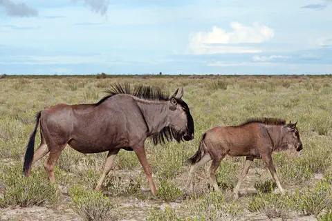
The blue wildebeest, or gnu, is a big antelope with a box-like head, curved horns, a mane and a beard. It grazes the savannas of eastern and southern Africa, and in the Serengeti huge herds travel in a giant circle every year following the rains.
-
 Watch
3D
Animal
Lion
The lion is the only big cat that lives in a family group, called a pride. Lionesses hunt together, males guard the pride's land, and their roar can be heard about 8 kilometers away. Wild lions live in Africa, plus one small group in western India.
- Watch Geography Types of volcanoes Volcanoes come in different shapes. Runny lava builds wide, gentle shield volcanoes like Mauna Loa. Sticky lava and ash build tall, steep stratovolcanoes like Mount Fuji. Small cinder cones grow from bits of lava thrown into the air. Whether lava is runny or sticky, and how much gas it holds, decides the shape and how explosive the eruptions are.
For parents & teachers
What children will learn
- Locate the Ngorongoro Conservation Area in northern Tanzania, next to the Serengeti.
- Explain how a caldera forms when a volcano collapses.
- Describe the crater's wildlife and its place in the great migration.
- Explain why Olduvai Gorge and Laetoli matter for understanding human origins.
Recommended ages: 3 to 17 · About 15 minutes
Talk about it
- How can people and wild animals share the same land?
- Why might a crater be a good home for so many animals?
- What can footprints tell scientists that bones cannot?
Try at home or in class
- Build a 'volcano' of damp sand over an upside-down paper cup, then gently press the cup down so the top collapses into a bowl, like a caldera.
- Press your feet into damp sand and measure the prints. What can you tell about how you walk?
Key vocabulary: caldera, crater, migration, pastoralist, fossil, predator
Where these facts come from
- Wikidata , Wikimedia Foundation (CC0 1.0)
- UNESCO World Heritage List , UNESCO World Heritage Centre (Linked as a reference; site facts come from Wikidata)
- Ngorongoro Conservation Area , UNESCO World Heritage Centre
- Ngorongoro Crater , Encyclopaedia Britannica
- Ngorongoro Crater , Ngorongoro Conservation Area Authority
- Visitor Guidelines and Procedures , Ngorongoro Conservation Area Authority
- Wikimedia Commons , Wikimedia Foundation (Per file (public domain, CC0, CC BY or CC BY-SA); see each media record)
Checked, not yet human-reviewed. Last updated October 27, 2026. Spotted a mistake? Tell us.