
City Africa
Windhoek
Windhoek is the capital city of Namibia, in southern Africa. It sits high up among hills, where the air is dry.
Windhoek is the capital of Namibia. It lies about 1,700 meters above the sea in a dry, hilly land. Namibia's 2023 census counted 486,186 people in Windhoek, about four times as many as in Rundu, the next-largest town.
Windhoek, capital of Namibia since independence in 1990, stands on hills at about 1,700 m above a valley between the Khomas Hochland and the Auas Mountains. Once watered by hot springs, it became the seat of colonial government in 1890. The 2023 census counted 486,186 residents, about 16% of all Namibians.
Photo: Diego Delso, CC BY-SA 4.0, via Wikimedia Commons
Discover Windhoek
Windhoek is the capital of Namibia, a country in southern Africa. It is the biggest town in the country.
The city is high up, on hills in a dry land.
Windhoek is the capital of Namibia and the main town of the Khomas Region. Universalis says its name means 'windy corner' and that it stands on hills about 1,700 meters above the sea, in a semi-arid land.
Namibia's census of 24 September 2023 counted 486,186 people in Windhoek. City Population's table of major towns, from the Namibia Statistics Agency, puts Rundu next, with 118,632.
The 2023 census (24 September; Namibia Statistics Agency figures on City Population) counted 486,186 people in Windhoek, out of 494,605 in the whole Khomas Region and 3,022,401 in Namibia, so about one Namibian in six lives in the capital. Khomas had 342,141 people at the 2011 census.
Universalis (Alain Dubresson, with 2005 figures) called Windhoek a demographic and economic center without equal in Namibia: 240,000 people, a third of the country's town dwellers, and 40% of its formal jobs.
- Country
- Namibia (capital since 1990)
- People in Windhoek (census, 24 September 2023)
- 486,186
- People in Khomas Region (census, 2023)
- 494,605
- Height above the sea
- about 1,700 m
A sandstone landmark
This building is called the Christuskirche. It is made of light brown stone, with a red roof and a tall, pointed tower with a clock.
A big palm tree grows beside it.
The photo shows the Christuskirche, or Christ Church. Its walls are blocks of light brown stone with white trim around the windows, and its steep roofs are red. A tall, pointed tower with clock faces rises at one end.
The photo's description on Wikimedia Commons says it was built between 1907 and 1910 from quartz sandstone found close by, to a design by the architect Gottlieb Redecker.
The Commons description (Diego Delso, 4 August 2018) gives the building's dates as 1907–1910 and its architect as Gottlieb Redecker, and sees neo-Romanesque, Art Nouveau and Gothic Revival influences in it. It was a Wikimedia Commons picture of the day on 15 May 2022.
In the photo, a low stone wall with black railings surrounds the building, a tall palm stands at the right and modern buildings show at the edges. Wikidata places the Alte Feste, a museum, about 0.2 km to the southeast.
- Christuskirche (Christ Church)
- built 1907–1910, according to the photo's Commons description
- Architect
- Gottlieb Redecker (same description)
- Alte Feste
- a museum, about 0.2 km southeast of the church
From hot springs to a capital
Long ago, warm springs gave this place water all year, even though the land is dry.
In 1990 Namibia became independent, and Windhoek became its capital.
Universalis says Windhoek's hot springs once gave the place a steady supply of water in a dry land. Around 1840, in the time of the Oorlam leader Jonker Afrikaner, it was a busy trading hub.
The site was left in 1880. From 1890, when a fort was built, it became the seat of the colonial government of South West Africa under German rule, and from 1914 under South African rule. Since 1990 it has been the capital of independent Namibia.
Universalis (Alain Dubresson) lists the site's advantages in a semi-arid land: hot springs that once guaranteed water all year, and a hilltop overlooking a fertile valley, a natural passage between the Khomas Hochland massif and the Auas Mountains.
After its days as a trading hub under Jonker Afrikaner (1840), the site was abandoned in 1880. It became the colonial capital of South West Africa in 1890 under German occupation and passed to South African rule in 1914. After independence in 1990, population growth sped up to 5.5% a year, with many people moving in from the north, Universalis said with 2005 figures.
- Trading hub
- in the time of Jonker Afrikaner (1840)
- Seat of colonial government
- from 1890
- Capital of independent Namibia
- since 1990
Railway and airport
Trains come to Windhoek's railway station. The airport is about 41 kilometers from the Christuskirche.
Wikidata dates Windhoek railway station to 1912. It stands about 1.1 kilometers northwest of the Christuskirche.
Windhoek Hosea Kutako International Airport, which Wikidata lists as opened in 1964, lies much farther out: about 41 kilometers east-northeast of the church. Wikidata describes it as the airport serving Windhoek, Namibia.
Universalis says the city's hill overlooks a fertile valley, a natural corridor between the Khomas Hochland and the Auas Mountains.
Measured from the Christuskirche (Wikidata points): the Alte Feste 0.21 km southeast, Windhoek railway station 1.13 km northwest and Hosea Kutako International Airport 40.59 km east-northeast.
Wikidata gives the railway station's opening as 1912 and the airport's as 1964; the airport's full name is Windhoek Hosea Kutako International Airport.
- Windhoek railway station
- opened 1912
- Hosea Kutako International Airport
- opened 1964
- Airport from the Christuskirche
- about 41 km east-northeast
Hot summers, dry winters
Windhoek is dry for most of the year. A little rain falls in summer, from about November to April.
Winter nights are chilly, but the days are mild.
The World Meteorological Organization's table for Windhoek (1961–1990) gives December days an average high of about 31 °C. In June, days average about 21 °C and nights about 7 °C.
Only about 368 millimeters of rain fall in an average year, almost all of it between November and April. February is the wettest month, with about 91 millimeters, and July is the driest, with just 0.1.
The WMO table for Windhoek (1961–1990) gives average highs from 20.7 °C in June to 31.4 °C in December and average lows from 6.9 °C in June and July to 17.7 °C in January.
The monthly rainfall averages add up to 367.8 mm, on 61.6 days a year with at least 0.1 mm. January to March bring 246.6 mm, two-thirds of the year; May to September together bring just 13.0 mm. Universalis calls the setting semi-arid.
- December, average high (WMO, 1961–1990)
- 31.4 °C
- June and July, average low (same table)
- 6.9 °C
- Rainfall in a year (sum of the monthly averages)
- about 368 mm
Offices, services and new industries
Many people in Windhoek work in offices for the government and in shops and services.
Some work in factories that make cloth.
Universalis says government and services provided most of the paid jobs in Windhoek, and that textile factories, set up from 2003, made the city's economy stronger.
It also says that being the capital, with government offices gathered there, explains much of the city's lead over the rest of Namibia, and that decentralization begun in 1992 did not slow it down.
Universalis (Alain Dubresson, with 2005 figures) says administration and services supplied most salaried jobs, the economic base was widened by textile industries from 2003, and the city council faced the fast spread of informal housing. It expected the capital might hold 25% of Namibia's people by 2030.
The 2023 census share was about 16% (486,186 of 3,022,401). Universalis noted that 60% of town dwellers lived on a fifth of the built-up area, in the north and northwest of the city.
- Formal jobs in Namibia (2005)
- 40% were in Windhoek
- Main employers
- government and services
- Textile industries
- since 2003
Windhoek on the map
Find Namibia on the globe, in southern Africa. Windhoek is its capital, high in the hills.
Windhoek lies at about 22.6° south, in Namibia's Khomas Region. Universalis places it on hills about 1,700 meters above the sea, above a valley between the Khomas Hochland and the Auas Mountains.
Measured from the Christuskirche, the Alte Feste is about 0.2 kilometers to the southeast, the railway station about 1.1 kilometers to the northwest and the international airport about 41 kilometers to the east-northeast.
Windhoek lies at about 22.57° S and 17.08° E. Measured from the Christuskirche (Wikidata points): Alte Feste 0.21 km southeast, railway station 1.13 km northwest, Hosea Kutako International Airport 40.59 km east-northeast.
Universalis (2005 figures) noted that Windhoek was four times as populous as Oshakati, in the north; by the 2023 census the next-largest town was Rundu (118,632).
- Latitude
- about 22.6° south
- Longitude
- about 17.1° east
- Christuskirche to the railway station
- about 1.1 km northwest
Amazing facts
-
The name Windhoek means 'windy corner'.
Universalis gives the meaning of the name Windhoek as 'windy corner'.
Universalis (Alain Dubresson) glosses Windhoek as 'coin venteux', a windy corner.
-
In July, Windhoek gets almost no rain at all.
In the WMO's Windhoek table, July averages just 0.1 millimeters of rain, while February averages about 91.
WMO Windhoek (1961–1990): May to September bring only 13.0 mm of rain together, out of 367.8 mm in the year.
-
Long ago, warm springs gave Windhoek its water.
Universalis says Windhoek's hot springs once guaranteed it water all year round, in a semi-arid land.
Universalis lists the hot springs among the site's advantages: they once guaranteed a permanent water supply on a hill overlooking a fertile valley.
-
Windhoek's airport is about 41 kilometers from the Christuskirche.
Hosea Kutako International Airport lies about 41 kilometers east-northeast of the Christuskirche.
Wikidata places Hosea Kutako International Airport (opened 1964) 40.59 km east-northeast of the Christuskirche.
Words to know
- capital
- the city where a country's government meets
- semi-arid
- dry, with only a little rain each year
- hot spring
- a place where warm water comes up out of the ground
- census
- an official count of all the people in a country
- colony
- a land ruled by another country far away
- independence
- when a country starts to rule itself
Discovery challenge
-
Windhoek is the capital of which country?
Windhoek is the capital of which country?
Windhoek has been the capital of which independent country since 1990?
- Botswana
- Namibia
- Angola
Show the answer
Namibia
Namibia!
Namibia.
Namibia.
-
What does the name Windhoek mean?
What does Universalis say the name Windhoek means?
Universalis glosses the name Windhoek as which phrase?
- Windy corner
- Big river
- Green valley
Show the answer
Windy corner
Windy corner!
'Windy corner'.
'Coin venteux', a windy corner.
-
When does most rain fall in Windhoek?
In which months does Windhoek get most of its rain?
In the WMO's Windhoek table, which three months bring two-thirds of the year's rain?
- June to August
- January to March
- It rains the same every month
Show the answer
January to March
In summer, from January to March!
January to March; winter is very dry.
January to March: 246.6 of 367.8 mm.
-
What did Windhoek's warm springs give people long ago?
What did Windhoek's hot springs once provide?
According to Universalis, what did the hot springs once guarantee?
- Water
- Gold
- Electricity
Show the answer
Water
Water!
A steady supply of water.
A permanent water supply.
-
What is the Christuskirche made of?
The Christuskirche was built of which kind of stone?
According to its Commons description, the Christuskirche was built of which local stone?
- Sandstone
- Ice
- Marble
Show the answer
Sandstone
Stone called sandstone!
Sandstone, found close by.
Quartz sandstone from the area.
Nearby places
-
 Watch
Natural wonder
Namib
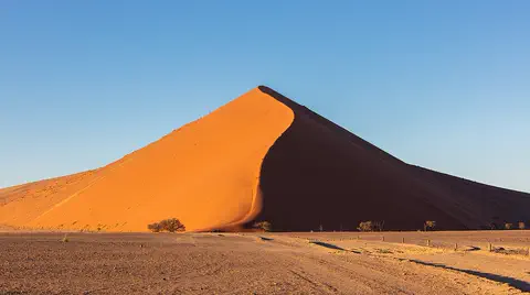
The Namib is a cool desert that runs for about 1,900 kilometers along Africa's Atlantic coast, from Angola through Namibia into South Africa. It gets almost no rain, but cold ocean water makes thick fog that drifts inland. UNESCO says its Namib Sand Sea is the only coastal desert in the world with huge dune fields influenced by fog.
-
 Watch
Natural wonder
Kalahari Desert
The Kalahari is a giant sandy plain in southern Africa, covering almost all of Botswana and parts of Namibia and South Africa. It stretches about 1,600 kilometers from north to south. Its southwest is a true desert, with long red dunes, while its north is green with woodlands and even has a huge swamp, the Okavango Delta.
-
 Watch
Landmark
Tsodilo
Tsodilo is a small group of rocky hills in the Kalahari Desert of Botswana. With more than 4,500 rock paintings in an area of only 10 square kilometers, it has been called the 'Louvre of the Desert'. People have used these hills for at least 100,000 years.
-
 Watch
Natural wonder
Okavango Delta
The Okavango Delta, in northwestern Botswana, is a huge wetland in the middle of a dry land. The Okavango River flows in from Angola, spreads out into channels, lagoons and grassy plains, and then soaks away into the sands of the Kalahari instead of reaching the sea. Its flood arrives in the dry season, drawing elephants, buffalo, zebras and many other animals.
-
 Watch
City
Gaborone
Gaborone is the capital of Botswana, in southern Africa. It was built as a new capital in the 1960s, almost ready when Botswana became independent in 1966. Planned for 20,000 people, it counted 246,325 in the 2022 census.
-
 Watch
Natural wonder
Victoria Falls
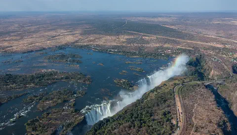
Victoria Falls, on the Zambezi River between Zambia and Zimbabwe, is about 1,708 meters wide and up to 108 meters deep. UNESCO calls it the largest curtain of falling water in the world, and its spray can be seen from tens of kilometers away.
-
 Watch
Landmark
Cradle of Humankind
The Cradle of Humankind is a landscape of grassy hills and limestone caves near Johannesburg, South Africa. Its caves, such as Sterkfontein, Swartkrans and Kromdraai, have held fossils of early human relatives, other animals and stone tools. It became a UNESCO World Heritage Site in 1999.
-
 Watch
City
Bloemfontein
Bloemfontein is the capital of the Free State province of South Africa. It is also called the country's judicial capital, because the Supreme Court of Appeal meets there. It began in 1846 as a small British post on the grassy plains.
Explore next
-
Watch
 Country
Namibia
Namibia lies on the southwestern coast of Africa. The Namib, a desert of huge dunes kept alive by sea fog, runs along its coast, a high plateau with farms and wildlife fills its middle, and the dry Kalahari lies to the east. Namibia became independent in 1990.
-
 Watch
City
Cape Town
Cape Town, South Africa's oldest city, sits between Table Bay and Table Mountain. It is one of the country's three capitals, the seat of Parliament. The 2022 census counted 4,772,846 people in the City of Cape Town, and the mountains around it are part of one of the richest plant regions on Earth.
-
 Watch
City
Johannesburg
Johannesburg is South Africa's most populous city, high on the country's central plateau. It grew very fast after gold was discovered in the Witwatersrand in 1886. Today it is the capital of Gauteng province, and the 2022 census counted 4,803,262 people in the City of Johannesburg.
-
 Watch
City
Luanda
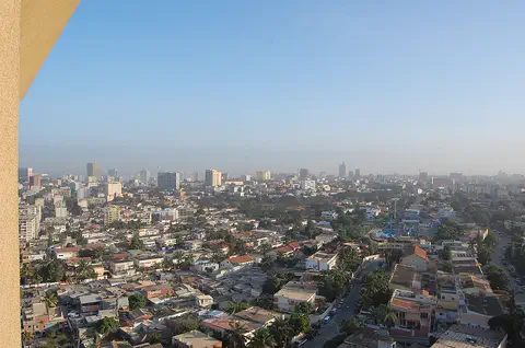
Luanda is the capital of Angola, on the Atlantic coast of Africa. It began in 1575 as a Portuguese fort and trading post beside a bay, and it is now Angola's largest city: the 2024 census counted 8,642,051 people there.
-
 Watch
City
Lusaka
Lusaka is the capital of Zambia, an African country with no coast. Zambia's 2022 census counted 2,212,301 people in the city, by far the most in the country. Lusaka was planned in the 1930s as a new capital and officially opened in 1935.
-
Watch
City
Gaborone
Gaborone is the capital of Botswana, in southern Africa. It was built as a new capital in the 1960s, almost ready when Botswana became independent in 1966. Planned for 20,000 people, it counted 246,325 in the 2022 census.
-
 Watch
City
Abidjan
Abidjan is the largest city of Côte d'Ivoire, with 5,616,633 people at the 2021 census. Spread around the Ébrié Lagoon, it grew from a colonial port: a canal finished in 1950 opened the lagoon to ships, and its Plateau district is a cluster of office towers, banks and government buildings.
-
 Watch
City
Abuja
Abuja is the capital of Nigeria, in the middle of the country. It was planned from the start: in 1976 the government decided to build a new capital on the savanna, and in 1991 it moved there from Lagos. Planners set aside land for parks and green spaces, and the huge Aso Rock rises at the city's edge.
For parents & teachers
What children will learn
- Locate Windhoek in the highlands of Namibia, in southern Africa.
- Explain why water sources matter for where towns grow in dry lands.
- Read a climate with hot summers, a short rainy season and very dry winters.
- Compare a capital's population with the country's total.
Recommended ages: 3 to 17 · About 15 minutes
Talk about it
- Hot springs once gave Windhoek its water. Why do you think towns in dry places often grow near water?
- About one Namibian in six lives in Windhoek. What might draw so many people to a capital city?
- Windhoek gets almost no rain from May to September. How might families and farms plan for the dry months?
Try at home or in class
- Rain chart: plot Windhoek's monthly rainfall and compare it with your town's.
- Height check: find 1,700 meters on a mountain you know and compare it with Windhoek's height.
- Building sketch: draw the Christuskirche from the photo and label its tower, clock, roof and windows.
Key vocabulary: capital, semi-arid, hot spring, census, colony, independence
Where these facts come from
- Wikidata , Wikimedia Foundation (CC0 1.0)
- Natural Earth vector data , Natural Earth (NACIS) (Public domain)
- Namibia: Regions and Major Towns (census results) , City Population (Thomas Brinkhoff), from the Namibia Statistics Agency
- Windhoek , Encyclopaedia Universalis (Alain Dubresson)
- World Weather Information Service: Windhoek climatological information , World Meteorological Organization
- File:Iglesia de Cristo, Windhoek, Namibia, 2018-08-04, DD 02.jpg (Diego Delso, 4 August 2018) , Wikimedia Commons
- Wikimedia Commons , Wikimedia Foundation (Per file (public domain, CC0, CC BY or CC BY-SA); see each media record)
Checked, not yet human-reviewed. Last updated November 1, 2026. Spotted a mistake? Tell us.