
City Asia
Palembang
Palembang is a big river city in Indonesia. A huge red bridge crosses the water there!
Palembang is a city on the Musi River, in the south of the island of Sumatra, in Indonesia. The encyclopedia Larousse says it was once the capital of the kingdom of Srivijaya. Indonesia's 2020 census counted 1,668,848 people in the city.
Palembang, a provincial capital on the Musi in southern Sumatra (Larousse), had 1,668,848 inhabitants as a city (kota) at Indonesia's census of 15 September 2020 (City Population, from Badan Pusat Statistik); Larousse says it was the capital of the Srivijaya kingdom, then of a sultanate from the 14th century to 1825, and is the center of a region of plantations and oil fields.
Photo: baka_neko_baka, CC BY 2.0, via Wikimedia Commons
Discover Palembang
Palembang is a city in Indonesia, a country made of many islands.
It is on Sumatra, a very big island, beside a wide river.
Palembang is a city in the south of Sumatra, the westernmost of Indonesia's large islands. The French encyclopedia Larousse places it on the Musi River and names it, with Medan, one of Sumatra's main cities.
Indonesia's census of 15 September 2020 counted 1,668,848 people in the city of Palembang.
Larousse ('Palembang'): a town of Indonesia, chef-lieu of a province, in the south of Sumatra, on the Musi; population 1,452,840 (2010 census); capital of the Srivijaya kingdom, then of a sultanate from the 14th century to 1825; center of a region of plantations and oil fields (oil refinery, fertilizer, shipyards, rubber). Larousse ('Sumatra'): the westernmost of Indonesia's large islands; main cities Medan and Palembang. City Population (from Badan Pusat Statistik), 'Kota Palembang', City: 1,342,258 (census 30 June 2005), 1,455,284 (census 1 May 2010), 1,578,582 (census 1 May 2015), 1,668,848 (census 15 September 2020).
- Country
- Indonesia, in the south of Sumatra, on the Musi River (Larousse)
- People in the city (census, 15 September 2020)
- 1,668,848 (Kota Palembang)
- Role
- the main town of its province, South Sumatra (Larousse; City Population)
- One of Sumatra's main cities
- with Medan (Larousse)
The big red bridge
Look at the giant red bridge with two tall towers!
A small, colorful boat sails on the brown river below.
The photographer baka_neko_baka took this photo of the Ampera Bridge on 27 August 2017. It shows two tall red towers, a long red span resting on wide pale pillars, a wide brown river, a small colorful boat on the water and a deep blue sky. A crane stands at the left edge.
Wikidata describes the Ampera Bridge as a vertical-lift bridge, a kind of bridge whose middle part was built to rise between its towers. Its point is about 0.9 kilometers south of the city's point.
Commons: 'Ampera Bridge (36869219905)', a Flickr photo by baka_neko_baka (CC BY 2.0, FlickreviewR 2 passed February 2020; uploaded by Glabb), taken 27 August 2017 at 17:06; camera point 2.9913° S, 104.7614° E, 0.95 km SSW of the city's Wikidata point. The photo shows the bridge's two red towers with the name board 'AMPERA', its red span on pale piers, the brown river, a passenger boat with a few tiny figures, a crane at the left. Wikidata, from the city point (Q8131): Ampera Bridge (Q643147), instance of vertical-lift bridge, 0.94 km S; Ampera LRT station (Q56036892), inception 2018, 0.68 km SSW.
- In the photo
- the Ampera Bridge, 27 August 2017 (baka_neko_baka)
- Ampera Bridge
- a vertical-lift bridge about 0.9 km south of the city's point (Wikidata)
- Ampera LRT station
- a light-rail station from 2018, about 0.7 km south-southwest (Wikidata)
A kingdom's capital
Long ago, Palembang was the capital of a kingdom!
Today it is a very big city.
Larousse says Palembang was the capital of the kingdom of Srivijaya, and later the capital of a sultanate, a land ruled by a sultan, from the 14th century until 1825.
Much later, Indonesia's censuses counted 1,455,284 people in 2010 and 1,668,848 in 2020. Between 2005 and 2020 the count rose by more than 300,000 people.
Larousse: 'Palembang fut la capitale du royaume de Shrivijaya puis celle d'un sultanat du XIVe s. à 1825.' City Population, Kota Palembang: 2005 1,342,258; 2010 1,455,284; 2015 1,578,582; 2020 1,668,848; 1,668,848 ÷ 1,455,284 ≈ 1.15.
- Srivijaya
- Palembang was the capital of the kingdom of Srivijaya (Larousse)
- 14th century to 1825
- the capital of a sultanate (Larousse)
- 2010 and 2020 censuses
- 1,455,284 and 1,668,848 people (City Population)
Bridge, light rail and railway
People cross the river on the big red bridge.
Trains run here too!
Larousse places Palembang on the Musi River. On Wikidata, the Ampera Bridge is about 0.9 kilometers south of the city's point, and the Ampera light-rail station, which Wikidata dates to 2018, about 0.7 kilometers south-southwest.
Kertapati railway station is about 4.0 kilometers south-southwest of the city's point. Larousse also mentions shipyards in the city.
Wikidata from the city point (Q8131): Ampera LRT station (Q56036892, inception 2018) 0.68 km SSW; Ampera Bridge (Q643147) 0.94 km S; Kertapati railway station (Q19748476) 3.96 km SSW. Larousse: on the Musi; chantiers navals (shipyards).
- Light rail
- Ampera LRT station, dated 2018 on Wikidata
- Railway
- Kertapati railway station, about 4.0 km south-southwest of the city's point (Wikidata)
- River
- the Musi (Larousse)
Rain all year round
Palembang is warm every month of the year.
It rains a lot, and March is the wettest month.
The Japan Meteorological Agency's averages for Palembang, for 1991 to 2020, show average temperatures between 26.7 °C and 27.7 °C in every month: warm all year.
About 2,649 millimeters of rain fall in a year. March is the wettest month, with 367.8 millimeters, and August the driest, with 64.5. Larousse describes Sumatra's climate as equatorial, with 2 to 4 meters of rain spread through the year.
Japan Meteorological Agency, world climate normals (period 1991-2020, stated on the normals index page), station Palembang (パレンバン), 2.90° S 104.70° E, 11.7 km NW of the city point: monthly mean temperature 26.7, 26.7, 27.1, 27.4, 27.7, 27.4, 27.2, 27.4, 27.7, 27.6, 27.1, 26.9 °C; precipitation 264.2, 233.4, 367.8, 323.9, 163.5, 151.8, 121.5, 64.5, 117.2, 207.8, 329.0, 303.9 mm (Jan-Dec); sum 2,648.5 mm. Check: Larousse ('Sumatra') gives the island's equatorial climate 2 to 4 m of rain falling all through the year: consistent. The WMO entry for Palembang has no climate months.
- Average temperature (JMA, Palembang, 1991–2020)
- 26.7 °C to 27.7 °C in every month
- Wettest and driest months (same table)
- March, 367.8 mm; August, 64.5 mm
- Rain in a year (twelve months added up)
- about 2,649 mm
Oil, rubber and ships
People in Palembang work with oil, rubber and ships.
The region around it has plantations and oil fields.
Larousse calls Palembang the center of a region of plantations and oil fields. It names an oil refinery, fertilizer making, shipyards where boats are built and rubber among the city's work.
Wikidata also lists a Songket Museum in Palembang, about 2.2 kilometers southwest of the city's point. Larousse also notes hills in the Palembang region, in an eastern plain of Sumatra that is often flooded and marshy.
Larousse: centre d'une région de plantations et de gisements pétrolifères (raffinerie de pétrole, engrais, chantiers navals, caoutchouc). Wikidata: Songket Museum (Q108934715), a museum in Palembang, inception 2014, 2.22 km SW. Larousse ('Sumatra'): the eastern plain of the island is often flooded and marshy, with hills in the Palembang region.
- Region
- plantations and oil fields (Larousse)
- Industry
- an oil refinery, fertilizer, shipyards and rubber (Larousse)
- Songket Museum
- a museum in Palembang, about 2.2 km southwest (Wikidata)
Palembang on the map
Find Indonesia on the globe, then the long island of Sumatra. Palembang is in its south, just south of the equator.
Palembang lies at about 2.98° south and 104.76° east, just south of the equator, in the south of Sumatra.
On Wikidata, the Ampera LRT station is about 0.7 kilometers south-southwest of the city's point, the Ampera Bridge about 0.9 kilometers south and the Songket Museum about 2.2 kilometers southwest.
Palembang lies at about 2.98° S, 104.76° E (Wikidata point of Palembang, Q8131; the sheet point is 1.91 km WNW of it). Wikidata from the city point: Ampera LRT station 0.68 km SSW; Ampera Bridge 0.94 km S; Songket Museum 2.22 km SW; Kertapati railway station 3.96 km SSW. The JMA station is 11.7 km NW.
- Latitude
- about 2.98° south
- Longitude
- about 104.76° east
- Island
- Sumatra, in its south (Larousse)
Amazing facts
-
Palembang's big red bridge was made so its middle could lift up!
Wikidata describes the Ampera Bridge as a vertical-lift bridge, a type whose middle part is built to rise between its two towers.
Wikidata: Ampera Bridge (Q643147), instance of vertical-lift bridge.
-
Palembang gets lots of rain: about 2,649 millimeters a year!
In the Japan Meteorological Agency's averages for 1991 to 2020, Palembang gets about 2,649 millimeters of rain a year, and March alone brings 367.8 millimeters.
JMA 1991–2020, Palembang: annual sum 2,648.5 mm; March 367.8 mm.
-
Long ago, Palembang was the capital of a kingdom!
Larousse says Palembang was the capital of the kingdom of Srivijaya, then of a sultanate from the 14th century until 1825.
Larousse ('Palembang'): capitale du royaume de Shrivijaya puis celle d'un sultanat du XIVe s. à 1825.
Words to know
- census
- an official count of all the people living in a place
- vertical-lift bridge
- a bridge whose middle part can be raised straight up so tall boats can pass under
- sultanate
- a land ruled by a sultan
- plantation
- a large farm where one crop, such as rubber trees, is grown
- refinery
- a factory that turns crude oil into fuels
- equatorial
- near the equator: hot and wet all year
Discovery challenge
-
Palembang is on which big island?
On which Indonesian island is Palembang?
In the south of which island does Larousse place Palembang?
- Sumatra
- Madagascar
- Greenland
Show the answer
Sumatra
Sumatra!
Sumatra.
Sumatra.
-
What color is Palembang's big bridge?
What color is the Ampera Bridge in the photo?
In the 2017 photo, what color are the Ampera Bridge's towers and span?
- Red
- Green
- Yellow
Show the answer
Red
Red!
Red.
Red.
-
Which river flows through Palembang?
On which river does Larousse place Palembang?
According to Larousse, Palembang lies on which river?
- The Musi
- The Nile
- The Volga
Show the answer
The Musi
The Musi!
The Musi River.
The Musi.
-
Which month brings the most rain to Palembang?
In the 1991–2020 averages, which is Palembang's wettest month?
Which month has the highest mean precipitation in JMA's 1991–2020 normals for Palembang?
- March
- August
- July
Show the answer
March
March!
March, with 367.8 millimeters.
March, 367.8 mm.
Nearby places
-
 Watch
Natural wonder
Krakatoa
Krakatoa, also called Krakatau, is a volcano between the Indonesian islands of Java and Sumatra. After an enormous eruption in 1883 destroyed the old island, a new volcano, Anak Krakatau, meaning 'child of Krakatau', rose from the sea about fifty years later. It still erupts often.
-
 Watch
City
Jakarta
Jakarta, Indonesia's largest city and its capital, lies on the northwest coast of the island of Java, where the Ciliwung River meets the Java Sea. About 11 million people live there (2025). Indonesia is building a new capital called Nusantara, but under the law Jakarta stays the capital until the president signs a decree moving it.
-
 Watch
Natural wonder
Java
Java is an island of Indonesia on the Pacific Ring of Fire, and it has many active volcanoes. Its tallest, Mount Semeru, is also its most active. At its western tip, Ujung Kulon National Park protects the island's largest remaining lowland rainforest and the endangered Javan rhinoceros.
-
 Watch
Landmark
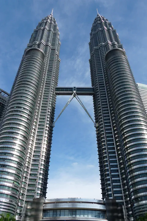
Petronas Towers
The Petronas Twin Towers in Kuala Lumpur, Malaysia, are two matching skyscrapers 452 meters tall, finished in 1998. Seen from above, each floor is shaped like an eight-pointed star, a pattern from Islamic art. A two-story skybridge joins them 170 meters above the ground, and from 1996 to 2003 they were counted as the tallest buildings in the world.
-
 Watch
City
Kuala Lumpur
Kuala Lumpur is the capital and largest city of Malaysia, in Southeast Asia. It began in 1857 as a settlement of Chinese tin miners where two rivers meet, and its name means "muddy estuary" in Malay. Today about 2.08 million people live there (2026 estimate), among skyscrapers, mosques and old shop-houses.
-
 Watch
Landmark
Borobudur
Borobudur is a huge Buddhist monument in central Java, Indonesia, built about 1,200 years ago. It is shaped like a stepped pyramid around a small hill, with carved walls and 72 bell-shaped stupas on its round top terraces. For centuries it lay hidden under volcanic ash and plants, and today it is a UNESCO World Heritage Site.
-
 Watch
Landmark
Prambanan Temple
Prambanan Temple is a huge group of Hindu temples on the island of Java in Indonesia, about 17 kilometers east of the city of Yogyakarta. Its tall, pointed stone towers date from the 9th century AD. Together with nearby Buddhist temples, it forms a UNESCO World Heritage Site.
-
 Watch
Natural wonder
Lake Toba
Lake Toba, in North Sumatra, Indonesia, fills a caldera left by one of the most powerful volcanic eruptions in Earth's history. UNESCO calls it the world's largest volcanic crater lake, with Samosir Island at its center.
Explore next
-
Watch
 Country
Indonesia
Indonesia is a country of about 17,500 islands in Southeast Asia, spread across the Equator between the Indian and Pacific oceans. It has more than 100 active volcanoes, rainforests full of wildlife, and about 286 million people (2025).
-
Watch
City
Jakarta
Jakarta, Indonesia's largest city and its capital, lies on the northwest coast of the island of Java, where the Ciliwung River meets the Java Sea. About 11 million people live there (2025). Indonesia is building a new capital called Nusantara, but under the law Jakarta stays the capital until the president signs a decree moving it.
-
Watch
Natural wonder
Lake Toba
Lake Toba, in North Sumatra, Indonesia, fills a caldera left by one of the most powerful volcanic eruptions in Earth's history. UNESCO calls it the world's largest volcanic crater lake, with Samosir Island at its center.
-
 Watch
City
Abu Dhabi
Abu Dhabi is the capital of the United Arab Emirates. It began in the 1700s as a small settlement around fresh water on an island, guarded by a coral-stone watchtower. Before oil, it relied on fishing and pearl diving; since the 1960s, money from oil has turned it into a city of towers. An official estimate gave the city about 1.75 million people in 2023.
-
 Watch
City
Almaty
Almaty is the main city of Kazakhstan, in the southeast of the country at the foot of the Ala-Tau mountains. It was founded in 1854 where a Kazakh village called Almaty, 'village of apple trees', stood. It was the capital until 1998, and about 2,387,900 people lived there on 1 September 2026.
-
 Watch
City
Amman
Amman is the capital of Jordan, built on steep hills around a valley high on a plateau. Long ago it was a Roman city called Philadelphia, and its Roman theater, carved into a hillside, still holds about 6,000 people. Today the city spreads across the hills, with houses faced in pale stone. About 4.6 million people lived in Amman Governorate at the end of 2021.
-
 Watch
City
Ankara
Ankara is the capital of Türkiye, in the interior of Anatolia, about 200 kilometers from the Black Sea. People have lived here since the Stone Age, and Romans, Byzantines, Seljuks and Ottomans all left buildings behind. It became the capital in 1923, and today it is a city of government, universities and museums.
-
 Watch
City
Ashgabat
Ashgabat is the capital of Turkmenistan, in Central Asia. It lies at the foot of the Kopet Dag mountains, with the Karakum Desert to the north. The 2022 census counted 1,030,063 people, and Guinness World Records lists the city for its many white marble buildings.
For parents & teachers
What children will learn
- Locate Palembang on the Musi River in southern Sumatra, Indonesia.
- Explain what a vertical-lift bridge is and why a river city might need one.
- Read a climate table for a place near the equator.
- Name the industries of a river port city.
Recommended ages: 3 to 17 · About 15 minutes
Talk about it
- Why might a city on a wide river build a bridge whose middle can lift?
- How is a place that is warm every month different from one with cold winters?
- Why might a kingdom choose a river city as its capital?
Try at home or in class
- Lift bridge: build a bridge from cardboard with a middle part on strings that you can raise, then float a paper boat under it.
- Rain bars: draw Palembang's twelve monthly rain bars and compare them with your own town's rain.
- Map trace: on a map of Indonesia, find Sumatra and draw the Musi River to Palembang.
Key vocabulary: census, vertical-lift bridge, sultanate, plantation, refinery, equatorial
Where these facts come from
- Wikidata , Wikimedia Foundation (CC0 1.0)
- Natural Earth vector data , Natural Earth (NACIS) (Public domain)
- Palembang , Larousse encyclopédie
- Sumatra , Larousse encyclopédie
- Indonesia: South Sumatra Province (Regencies and Cities) , City Population (Thomas Brinkhoff), from Badan Pusat Statistik
- Climate normals: Palembang (station 96221) , Japan Meteorological Agency
- World normals by region and country (normals period 1991-2020) , Japan Meteorological Agency
- Ampera Bridge (36869219905) , Wikimedia Commons
- Wikimedia Commons , Wikimedia Foundation (Per file (public domain, CC0, CC BY or CC BY-SA); see each media record)
Checked, not yet human-reviewed. Last updated November 1, 2026. Spotted a mistake? Tell us.