
City Asia
Kuala Lumpur
Kuala Lumpur is the capital of Malaysia. Two rivers meet there. Very tall twin towers shine over the city at night.
Kuala Lumpur is the capital and largest city of Malaysia, in Southeast Asia. It began in 1857 as a settlement of Chinese tin miners where two rivers meet, and its name means "muddy estuary" in Malay. Today about 2.08 million people live there (2026 estimate), among skyscrapers, mosques and old shop-houses.
Kuala Lumpur, the capital of Malaysia, grew from a tin miners' settlement founded in 1857 at the meeting of the Kelang (Klang) and Gombak rivers. It became the capital of the Federated Malay States in 1895, of independent Malaya in 1957 and of Malaysia in 1963, and a federal territory in 1974. The Department of Statistics Malaysia estimates its population at about 2.08 million in 2026.
Photo: naim fadil, CC BY-SA 2.0, via Wikimedia Commons
Discover Kuala Lumpur
Kuala Lumpur is a big city in Malaysia. It is the capital.
Many people call it KL. It has very tall buildings, parks and trains.
Kuala Lumpur is the capital of Malaysia. It sits in the west-central part of Peninsular Malaysia, about 40 kilometers from its seaport, Port Kelang, on the Strait of Malacca. It is the country's largest urban area and its center for culture, business and transport.
The 2020 census counted 1,982,112 people in the Federal Territory of Kuala Lumpur. The Department of Statistics Malaysia estimates about 2.08 million for 2026. Millions more live in the Klang Valley, the wider metropolitan area around the city.
Kuala Lumpur lies in west-central Peninsular Malaysia, midway along the west coast tin and rubber belt and about 40 km east of its seaport, Port Kelang, on the Strait of Malacca. In 1972 it was made a municipality, and in 1974 the city and nearby parts of the surrounding state of Selangor became a federal territory of 243 km².
The 2020 census counted 1,982,112 people in the federal territory. The Department of Statistics Malaysia's mid-year estimate for 2026 is 2,082,300, including about 869,000 Malay, 728,000 Chinese and 177,000 Indian Malaysian citizens and about 273,000 non-citizens. Many federal offices moved to the new city of Putrajaya, about 25 km to the south, around the turn of the 21st century, but Kuala Lumpur remained the capital.
- Country
- Malaysia (capital)
- People in the federal territory (2026 estimate)
- about 2,082,300
- People in the federal territory (2020 census)
- 1,982,112
- Area of the federal territory
- 243 km²
Twin towers and a city of tall buildings
Two silver towers stand side by side in Kuala Lumpur. They look like twins.
A bridge high in the sky joins them. Lots of other tall buildings stand nearby.
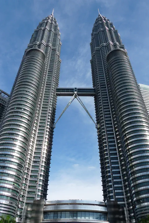
Kuala Lumpur's business district, called the Golden Triangle, lies on the east side of the Kelang River. Here stand the Petronas Twin Towers, 452 meters tall, with 88 floors each. Seen from above, each floor is shaped like an eight-pointed star, made from two squares laid over each other. A two-story skybridge joins the towers at levels 41 and 42, 170 meters above the ground.
Britannica lists the towers and Merdeka 118, which has 118 floors, among the world's tallest buildings. The Kuala Lumpur Tower, a 421-meter mast for broadcasting and telecommunications, rises nearby.
The Golden Triangle, Kuala Lumpur's commercial quarter, is concentrated on the east side of the Kelang. Britannica counts three of its towers among the world's tallest buildings: the 118-story Merdeka 118 and the two 88-story Petronas Twin Towers. It also lists the 421-meter Kuala Lumpur Tower among the tallest broadcasting and telecommunications masts.
The Petronas towers were designed by the Argentine architect César Pelli. According to the towers' official site, they were first proposed at 427 m; after structural parts were recalculated and retested in wind tunnels, a dome with an integrated pinnacle was added, bringing them to 452 m, above the Sears Tower in the United States. Each floor plate is based on two interlocking squares forming an eight-pointed star, an Islamic geometric form, and the facades combine stainless steel and glass. The 750-ton double-deck skybridge, 58.4 m long, links levels 41 and 42 and is not rigidly fixed to the towers, so it can allow for small movements in strong wind.
- Petronas Twin Towers
- 452 m tall, 88 floors each
- Skybridge between the towers
- levels 41 and 42, 170 m above the ground
- Kuala Lumpur Tower
- 421 m broadcasting and telecommunications mast
From a tin miners' camp to a capital
Long ago, miners came to dig for tin. Tin is a shiny metal.
They built a little town where two rivers meet. The town grew and grew. Now it is a capital city.
In 1857, a group of 87 Chinese tin miners started a settlement where the Kelang and Gombak rivers meet. Tin from the valleys was gathered there, and the town grew. In 1880 it became the state capital in place of Klang, and later a railway was built between Klang and Kuala Lumpur. In 1895 it became the capital of the Federated Malay States.
Japan occupied the city during World War II, from 1942 to 1945. In 1957 Kuala Lumpur became the capital of the independent Federation of Malaya, and in 1963 the capital of Malaysia.
Kuala Lumpur dates to 1857, when 87 Chinese tin miners founded a settlement at what is now the suburb of Ampang. Commanding both river valleys, it flourished as a tin-collecting center, and in 1880 it replaced Klang as the state capital. Britannica attributes its rapid growth afterward to Sir Frank Swettenham, British resident after 1882, who began the Klang–Kuala Lumpur railway and encouraged brick and tile buildings as a precaution against fire and for better health. Its central position led to its choice as capital of the Federated Malay States in 1895.
Japanese forces occupied the city from 1942 to 1945. It became the capital of the independent Federation of Malaya in 1957 and of Malaysia in 1963. Industrial growth followed: the population reached half a million in the mid-1960s and passed one million in the early 1980s.
- Chinese tin miners found a settlement
- 1857
- Capital of the Federated Malay States
- 1895
- Capital of independent Malaya; of Malaysia
- 1957; 1963
Light rail, a monorail and driverless trains
In Kuala Lumpur, trains run high above the roads. Some trains have no driver at all!
A monorail train runs on one single rail. A fast train goes to the airport.
Kuala Lumpur's first light metro line opened on 16 December 1996. In 1998 another line opened whose trains run with no driver, and UrbanRail.net says it was then the world's longest fully automated line. In 2003 the KL Monorail began running on a single rail built 10 meters above the main roads.
The first full metro line opened in 2016 and 2017, with 9.5 kilometers of tunnels under the city center. A new driverless line serving the western parts of the metropolitan area, the Shah Alam Line, opened in June 2026. To reach Kuala Lumpur International Airport, travelers can take the KLIA Ekspres, which runs 57 kilometers in about 28 minutes without stopping.
KTM Komuter suburban trains began running on the national railway's lines in mid-1995. The first light metro, STAR, opened in stages from 16 December 1996, and the PUTRA line followed in September 1998; UrbanRail.net notes it was the world's longest fully automated driverless line until Lille's Line 2 was extended in 2000. KL Sentral station opened in April 2001, the KL Monorail on 31 August 2003, and in 2004 the lines began to be brought together under the Rapid KL brand.
The Sungai Buloh–Kajang MRT line, the city's first full metro, opened in December 2016 and July 2017, running underground for 9.5 km beneath the center in twin-bore tunnels. The Putrajaya Line was completed to Putrajaya Sentral on 16 March 2023, and the 37.8 km driverless Shah Alam Line opened on 29 June 2026. The KLIA Ekspres, running since 14 April 2002, covers the 57 km from KL Sentral to the airport at Sepang in 28 minutes non-stop.
- First light metro line opened
- 16 December 1996
- KL Monorail opened
- 31 August 2003
- KLIA Ekspres to the airport
- 57 km, about 28 minutes non-stop
Hot, humid and rainy all year
Kuala Lumpur is warm all year. There is no cold winter.
It rains a lot. November is the rainiest month.
Kuala Lumpur is close to the Equator, and its weather changes very little through the year. The World Meteorological Organization's averages for 1971 to 2000 give daytime highs of about 31 to 33 °C and nighttime lows of about 22 to 24 °C in every month.
What changes is the rain. About 2,430 millimeters fall in an average year, more than twice as much as in Boston. November is the wettest month, with about 288 millimeters, and June and July are the driest, with about 125 millimeters each.
Britannica describes Kuala Lumpur's climate as equatorial, with high temperatures and humidity that vary little through the year. WMO normals for 1971–2000 confirm it: average highs range only from 31.5 °C in December to 33.2 °C in March, and average lows from 22.5 °C in January to 23.9 °C in May.
The monthly rainfall averages add up to about 2,427 mm. Two wetter spells stand out: March to April (240.9 and 259.2 mm) and October to December, peaking in November at 287.8 mm with about 18 rain days. June (125.3 mm) and July (127.2 mm) are the driest months, with 9 to 10 rain days.
- Average daily high (WMO, 1971–2000)
- about 31.5 to 33 °C in every month
- Average daily low (same period)
- about 22.5 to 24 °C in every month
- Rain in a year (sum of the monthly averages)
- about 2,430 mm
Markets, museums and a forest in the city
Kuala Lumpur has an old market full of art and crafts. It has gardens with orchids, too.
Near the tall towers, a forest grows on a hill called Pineapple Hill.
Central Market was built in 1888 as a wet market, a place to buy fresh food. Today it is a center for Malaysian art and crafts. Around the old city center are areas of Chinese shop-houses, where a family runs a shop downstairs and lives upstairs.
West of the Kelang River, the Lake Gardens are a large green belt with orchid gardens, the Parliament House, the National Museum of Malaysia and the National Planetarium. The Bukit Nanas ("Pineapple Hill") Forest Reserve, a smaller natural area, lies just northwest of the Golden Triangle.
Kuala Lumpur's buildings mix Western, Middle Eastern, East Asian and local influences: glass-and-concrete towers, mosques, Malay kampungs (villages) and Chinese two-story shop-houses, family businesses with the shop on the ground floor and the home above. Central Market, built in 1888 as a wet market, is now a center for Malaysian culture, art and craft.
The Lake Gardens, a greenbelt extending west from the Kelang opposite the central city, hold orchid gardens, wildlife areas, Parliament House, the National Museum of Malaysia (1963), the Islamic Arts Museum Malaysia (1999) and the National Planetarium (1993). The Bukit Nanas Forest Reserve lies just northwest of the Golden Triangle. The University of Malaya was founded in the city in 1962, and the National Sports Complex, just south of the city, was built for the 1998 Commonwealth Games.
- Central Market
- built 1888 as a wet market
- National Museum of Malaysia
- 1963, in the Lake Gardens
- University of Malaya
- founded in Kuala Lumpur in 1962
Kuala Lumpur on the map
Find Kuala Lumpur on the globe.
It is in Malaysia, in Asia. It is close to the Equator, the line around the middle of the Earth.
Kuala Lumpur is on the Malay Peninsula, in the west-central part of Peninsular Malaysia. It lies only about 3 degrees north of the Equator.
The city grew up where two rivers, the Kelang and the Gombak, flow together. In Malay, its name means "muddy estuary." Mountains of Malaysia's Main Range rise nearby to the north, east and southeast.
Kuala Lumpur lies at about 3.2° N and 101.7° E, in hilly country astride the confluence of the Kelang and Gombak rivers. The old Sultan's Mosque, Masjid Jamek, stands on the point of land where the rivers join.
The government buildings and the notable railway station, influenced by Moorish design, stand on the river's hilly west bank; the Moorish-style Sultan Abdul Samad Building was once the Secretariat Building. Port Kelang, on the Strait of Malacca, is about 40 km to the west, Putrajaya about 25 km to the south, and Kuala Lumpur International Airport, at Sepang, about 50 km to the south.
- Latitude
- about 3.2° north
- Longitude
- about 101.7° east
- Setting
- where the Kelang and Gombak rivers meet
Amazing facts
-
The name Kuala Lumpur means "muddy estuary."
In Malay, Kuala Lumpur means "muddy estuary." The city grew up where the Kelang and Gombak rivers flow together.
Kuala Lumpur means "muddy estuary" in Malay. The city sits astride the confluence of the Kelang and Gombak rivers, where Masjid Jamek, the old Sultan's Mosque, stands on the point between them.
-
A sky bridge joins the twin towers, high above the ground.
The skybridge between the Petronas Twin Towers is 170 meters above the ground. It is not fully fixed to the towers, so it can move a little in strong winds.
The double-deck skybridge, 58.4 m long and weighing 750 tons, links levels 41 and 42 at 170 m; the towers' official site says it is deliberately not fully attached, to allow for small movements in high winds.
-
One of Kuala Lumpur's trains rides on just one rail.
The KL Monorail runs on a track built 10 meters above the main roads, and its trains come every 5 to 7 minutes.
The KL Monorail, opened on 31 August 2003 with locally built trains based on Seattle's monorail, runs 8.6 km between Titiwangsa and KL Sentral on a track 10 m above the main roads.
-
An old food market in Kuala Lumpur is now full of art.
Central Market was built in 1888 as a wet market for fresh food. Today it is a center for Malaysian art and crafts.
Central Market, built in 1888 as a wet market, is today a center for Malaysian culture, art and craft.
Words to know
- estuary
- a place where a river widens and meets other water
- confluence
- the place where two rivers flow together
- tin
- a soft, silvery metal dug from the ground
- federal territory
- an area run by a country's national government instead of by a state
- monorail
- a railway whose trains run on a single rail
- shop-house
- a building with a shop on the ground floor and a family home upstairs
Discovery challenge
-
Kuala Lumpur is the capital of which country?
Kuala Lumpur is the capital of which country?
Kuala Lumpur, a federal territory since 1974, is the capital of which country?
- Thailand
- Malaysia
- Indonesia
Show the answer
Malaysia
Malaysia! Kuala Lumpur is its capital.
Malaysia. Kuala Lumpur is its capital and largest city.
Malaysia. It has been the capital since 1963, although many federal offices moved to Putrajaya.
-
What did the first people in Kuala Lumpur dig for?
What were the miners who founded Kuala Lumpur in 1857 looking for?
Kuala Lumpur flourished after 1857 as a collecting center for which metal?
- Gold
- Iron
- Tin
Show the answer
Tin
Tin! It is a shiny metal.
Tin. A group of 87 Chinese tin miners started the settlement.
Tin. The settlement commanded both river valleys and grew as a tin-collecting center.
-
What does the name Kuala Lumpur mean?
What does Kuala Lumpur mean in Malay?
What does the Malay name Kuala Lumpur mean?
- Muddy estuary
- Tall towers
- Green hill
Show the answer
Muddy estuary
Muddy estuary! Two rivers meet there.
Muddy estuary. The city stands where the Kelang and Gombak rivers meet.
"Muddy estuary." The city lies astride the confluence of the Kelang and Gombak rivers.
-
How many floors does each Petronas tower have?
How many floors does each of the Petronas Twin Towers have?
How many stories does each 452-meter Petronas tower have?
- 28
- 88
- 188
Show the answer
88
88 floors! That is very tall.
88 floors each, with a skybridge at levels 41 and 42.
88 above ground, plus 5 underground levels for parking and services.
-
Which month is the rainiest in Kuala Lumpur?
In which month does Kuala Lumpur get the most rain?
According to WMO normals for 1971–2000, which month is Kuala Lumpur's wettest?
- June
- November
- February
Show the answer
November
November! June is much drier.
November, with about 288 millimeters of rain. June and July are the driest months.
November, with 287.8 mm and about 18 rain days; June (125.3 mm) is the driest.
Nearby places
-
 Watch
Landmark
Petronas Towers
The Petronas Twin Towers in Kuala Lumpur, Malaysia, are two matching skyscrapers 452 meters tall, finished in 1998. Seen from above, each floor is shaped like an eight-pointed star, a pattern from Islamic art. A two-story skybridge joins them 170 meters above the ground, and from 1996 to 2003 they were counted as the tallest buildings in the world.
-
 Watch
Natural wonder
Lake Toba
Lake Toba, in North Sumatra, Indonesia, fills a caldera left by one of the most powerful volcanic eruptions in Earth's history. UNESCO calls it the world's largest volcanic crater lake, with Samosir Island at its center.
-
 Watch
Natural wonder
Mount Sinabung
Mount Sinabung is a 2,460-meter stratovolcano in North Sumatra, Indonesia. It had no eruption for about 1,200 years until 2010, and since 2013 scientists have watched it closely as it builds and loses lava domes.
-
 Watch
City
Palembang
Palembang is a city on the Musi River, in the south of the island of Sumatra, in Indonesia. The encyclopedia Larousse says it was once the capital of the kingdom of Srivijaya. Indonesia's 2020 census counted 1,668,848 people in the city.
-
 Watch
Natural wonder
Andaman Sea
The Andaman Sea is part of the eastern Indian Ocean, near Thailand and Myanmar, with the Andaman and Nicobar Islands nearby. Its rugged sea floor helps make large waves deep inside the water, and its islands have coral reefs and seagrass where dolphins and dugongs feed.
-
 Watch
City
Ho Chi Minh City
Ho Chi Minh City, once called Saigon, is Vietnam's largest city and the economic heart of the country. It lies on the Saigon River, north of the Mekong Delta. Since merging with two neighboring provinces in 2025, it has more than 14 million people, and in 2024 it opened its first metro line.
-
 Watch
Natural wonder
Krakatoa
Krakatoa, also called Krakatau, is a volcano between the Indonesian islands of Java and Sumatra. After an enormous eruption in 1883 destroyed the old island, a new volcano, Anak Krakatau, meaning 'child of Krakatau', rose from the sea about fifty years later. It still erupts often.
-
 Watch
Landmark
Angkor Wat
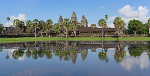
Angkor Wat, near the town of Siem Reap in Cambodia, was built in the 12th century by the Khmer king Suryavarman II. Britannica (2026) calls it the world's largest religious structure. It was built as a Hindu temple and later became a Buddhist place of worship.
Explore next
-
Watch
 Country
Malaysia
Malaysia is a country in Southeast Asia, just north of the Equator. One part is on the Malay Peninsula and the other is on the island of Borneo. It has rainforests, huge caves, Mount Kinabalu and the city of Kuala Lumpur, with about 34.4 million people (2026).
-
Watch
Landmark
Petronas Towers
The Petronas Twin Towers in Kuala Lumpur, Malaysia, are two matching skyscrapers 452 meters tall, finished in 1998. Seen from above, each floor is shaped like an eight-pointed star, a pattern from Islamic art. A two-story skybridge joins them 170 meters above the ground, and from 1996 to 2003 they were counted as the tallest buildings in the world.
-
 Watch
Landmark
Taipei 101
Taipei 101 is a skyscraper in Taipei, Taiwan, 508 meters tall with its spire and 101 stories high. When it opened, it was the tallest building in the world. Inside hangs a 660-ton steel ball, a tuned mass damper, that helps steady the tower in typhoon winds and earthquakes.
-
 Watch
City
Jakarta
Jakarta, Indonesia's largest city and its capital, lies on the northwest coast of the island of Java, where the Ciliwung River meets the Java Sea. About 11 million people live there (2025). Indonesia is building a new capital called Nusantara, but under the law Jakarta stays the capital until the president signs a decree moving it.
-
 Watch
City
Bangkok
Bangkok, the capital of Thailand, lies on the delta of the Chao Phraya River, about 40 kilometers from the sea. It became the capital in 1782, when the new royal palace and temples were built. Once called the 'Venice of the East' for its canals, it is now a huge, busy city with skyscrapers and an elevated railway.
- Watch Geography Monsoons A monsoon is a seasonal change in the direction of a region's strongest winds. In South Asia, the summer monsoon blows warm, wet air in from the Indian Ocean and brings months of heavy rain, while the winter monsoon blows dry air from the land. About three-quarters of India's yearly rain falls in the monsoon season, so farms, wells, rivers and power stations all depend on it.
- Watch Geography Capital cities A capital is the city where a country's government is based. Many capitals grew up over hundreds of years beside rivers and trade routes. A few, like Brasília and Canberra, were built from scratch, and some countries share out their capital's jobs among two or three cities.
-
 Watch
City
Vientiane
Vientiane is the capital of Laos, on the left bank of the Mekong River. Lao Statistics Bureau figures give Vientiane Capital, the prefecture around the city, an estimated 844,020 people in mid-2015.
For parents & teachers
What children will learn
- Locate Kuala Lumpur on the Malay Peninsula and name it as the capital of Malaysia.
- Explain how a mining settlement at a river meeting point grew into a capital city.
- Describe how tall buildings like the Petronas Twin Towers are designed for wind.
- Read monthly rainfall averages to compare a tropical city with a city that has seasons.
Recommended ages: 3 to 17 · About 15 minutes
Talk about it
- Kuala Lumpur began where two rivers meet. Why might people choose to build a town at a place like that?
- Many government offices moved from Kuala Lumpur to a new city, Putrajaya. What are good and hard things about moving offices to a new place?
- The skybridge between the towers can move a little in the wind. Why might it be safer for a bridge to move a little than to be stiff?
Try at home or in class
- Build twin towers: stack paper cups or blocks into two equal towers and join them with a strip of card. Blow gently with a fan or a book and see whether a loose or a taped bridge holds better.
- Rain gauge: put a straight-sided jar outside and measure the rain for a week. Compare it with Kuala Lumpur's 288 millimeters in an average November.
- Draw an eight-pointed star: lay one square on top of another and turn it until the corners make eight points, like the floor plan of each Petronas tower.
Key vocabulary: estuary, confluence, tin, federal territory, monorail, shop-house
Where these facts come from
- Wikidata , Wikimedia Foundation (CC0 1.0)
- Natural Earth vector data , Natural Earth (NACIS) (Public domain)
- Kuala Lumpur , Encyclopaedia Britannica
- Population Table: States , Department of Statistics Malaysia (OpenDOSM)
- Design + Structure , PETRONAS Twin Towers official website (Wayback Machine copy of August 22, 2026)
- Kuala Lumpur , UrbanRail.Net
- Central Market Kuala Lumpur , Central Market Kuala Lumpur
- Kuala Lumpur: climatological information , World Meteorological Organization, World Weather Information Service
- LRT3 Shah Alam debuts smoothly, no women-only coach planned yet, says Prasarana , Malay Mail
- Wikimedia Commons , Wikimedia Foundation (Per file (public domain, CC0, CC BY or CC BY-SA); see each media record)
Checked, not yet human-reviewed. Last updated November 1, 2026. Spotted a mistake? Tell us.