
City Asia
Jakarta
Jakarta is the biggest city in Indonesia. It is on the island of Java, by the sea. It is hot and rainy, and very, very busy.
Jakarta, Indonesia's largest city and its capital, lies on the northwest coast of the island of Java, where the Ciliwung River meets the Java Sea. About 11 million people live there (2025). Indonesia is building a new capital called Nusantara, but under the law Jakarta stays the capital until the president signs a decree moving it.
Jakarta, on Jakarta Bay at the mouth of the Ciliwung, dates its official history to 1527, was the Dutch colonial capital Batavia from 1619, and became the capital of independent Indonesia, recognized as such in 1949. Low-lying and flood-prone, it is a megacity of about 11 million (2025). Nusantara, in East Kalimantan, is designated by law as the future capital, but in May 2026 the Constitutional Court confirmed that Jakarta remains the capital until a presidential decree on the move is issued.
Photo: Amelia Guo, CC BY 3.0, via Wikimedia Commons
Discover Jakarta
Jakarta is a giant city in Indonesia.
It is on the island of Java, beside the sea. A river flows through it to the sea. Millions and millions of people live there.
Jakarta is the capital and largest city of Indonesia, a country of many islands. It lies on the northwest coast of the island of Java, on Jakarta Bay, where the Ciliwung River flows into the Java Sea.
About 11 million people lived in Jakarta in 2025. The city is a center for trade, banking, industry and schools. Its port, Tanjung Priok, is the biggest in Indonesia, and many people from other parts of Java and from Sumatra have moved here to work.
Jakarta lies on the northwest coast of Java at the mouth of the Ciliwung, on Jakarta Bay, an inlet of the Java Sea. It is nearly coextensive with the special capital district (daerah khusus ibukota), which also includes small islands offshore; declared a special capital district in 1966, it has roughly the status of a province, and Greater Jakarta is divided into five administrative municipalities.
The city's official population register counted 11,010,514 people in the first half of 2025. Britannica describes it as a long-standing trade and financial center that has also become an industrial and educational hub, handling roughly a quarter of Indonesia's trade and services and two-thirds of its banking and finance. Much of its growth since 1940 has come from migration, above all from West, Central and East Java and from Sumatra.
- Country
- Indonesia (capital)
- People in the city (2025)
- about 11 million
- Area of the special capital district
- 661 km²
- Capital status (2026)
- capital until a presidential decree moves it to Nusantara
Famous places
In the middle of Jakarta is a huge open square.
A tall monument stands in it, and you can look out from the top. Nearby are a palace, a big museum and a very large mosque. The old part of the city has buildings from long ago.
At the heart of Jakarta is Medan Merdeka, "Freedom Field," a huge square. In it stands Monas, the National Monument, which has an observation deck at the top. The Presidential Palace faces Monas, the National Museum stands on the west side of the square, and the Istiqlal Mosque, one of the largest mosques in Southeast Asia, is in its northeast corner.
In the north is Kota, the Old City, once the Dutch town of Batavia. Its old city hall, from 1710, is now a museum, and the Portuguese Church dates from 1695.
Britannica notes that although the Dutch first planned the city, its large squares, such as Medan Merdeka ("Freedom Field") and Lapangan Banteng, give it a layout that is probably more British than Dutch. The Presidential Palace, north of Medan Merdeka, faces Monas, the National Monument; the National Museum, on the square's west side, holds historical, cultural and artistic artifacts; and the Istiqlal Mosque, at its northeast corner, is one of the largest mosques in Southeast Asia.
In Kota, or Old Batavia, the historic center that is home to much of the city's Chinese community, the old city hall (1710) has been restored as the municipal museum, and the Portuguese Church (1695) survives. The National Archives building was once a Dutch governor-general's palace. After World War II came a building boom: the Hotel Indonesia, the city's first high-rise, and the Senayan Sports Complex were built for the 1962 Asian Games, and high-rises now cluster in the financial center along Sudirman and Thamrin roads.
- Old City Hall (now a museum)
- 1710
- Portuguese Church
- 1695
- Hotel Indonesia, first high-rise
- built for the 1962 Asian Games
From Jayakerta to Jakarta
People have lived by this river for a very long time.
Long ago, the town was called Jayakerta. Later, people from the Netherlands ruled it and called it Batavia. Today it is Jakarta, the capital of Indonesia.
People may have lived at the mouth of the Ciliwung River as early as the 400s. Jakarta's official history begins in 1527, when the place was named Jayakerta, meaning "Glorious Fortress." In 1619 the Dutch took the town and built a walled settlement called Batavia, with canals like a town in the Netherlands.
Batavia became the capital of the Dutch East Indies. After Indonesia declared independence on August 17, 1945, the city was called Djakarta, and in 1949 it was officially proclaimed the national capital. Since then it has grown into one of the largest cities in tropical Asia.
Settlements at the Ciliwung's mouth may date to the 5th century CE. The official history begins in 1527, when the sultan of Bantam defeated the Portuguese there and named the place Jayakerta ("Glorious Fortress"). The Dutch under Jan Pieterszoon Coen captured and razed it in 1619 and built Batavia, a walled, canal-lined township that became the capital of the Dutch East Indies. In the early 1800s the city spread south to higher, healthier ground; British control interrupted Dutch rule until 1815, and the city modernized from about the 1920s to 1941.
Japan occupied Indonesia in World War II. During the occupation, and again after nationalists declared independence on August 17, 1945, the city was called Djakarta; it was officially proclaimed the national capital on December 27, 1949. It grew rapidly under Presidents Sukarno and Suharto. Nusantara, in East Kalimantan, was designated as the future capital in 2022, and a 2025 presidential regulation set 2028 as the target for it to work as the political capital. In its ruling of May 12, 2026, the Constitutional Court held that Jakarta remains the capital as long as the presidential decree on moving the capital has not been issued.
Getting around Jakarta
Jakarta has very busy roads.
Now a fast train called the MRT zooms across the city. Some people ride little tricycle taxis near their homes. Big ships come to the city's port.
Traffic jams are a big problem in Jakarta, especially in the morning and evening rush hours. To help, the city opened its first MRT line, a fast metro train, on March 24, 2019, running from Lebak Bulus to the Bundaran HI traffic circle. A second phase, to Kota in the north, is being built, and a light-rail line has run since late 2019.
Buses, minibuses and taxis carry many people, and in some neighborhoods people ride the becak, a tricycle taxi. Trains link Jakarta with the rest of Java, and its port, Tanjung Priok, is the largest in Indonesia.
Britannica describes traffic congestion and pollution as major problems, with jams at morning and afternoon rush hours. To shift people from private vehicles to public transport, the city opened MRT Phase 1 (Lebak Bulus to Bundaran HI) to the public on March 24, 2019, averaging about 94,800 riders a day by July 2019; Phase 2 (Bundaran HI to Kota) is under construction, and LRT Phase 1 (Velodrome to Pegangsaan Dua) has run since late 2019.
Railways run east across Java, south to Bogor and Bandung and west to the ferry port of Merak, for Sumatra. Tanjung Priok, Indonesia's largest port, handles much of the country's imports, many of them transshipped to other islands. The main international airport is about 20 km west at Cengkareng. Buses and minibuses carry most public transport, while the becak, a tricycle taxi, serves only neighborhood trips.
- MRT Phase 1 (Lebak Bulus–Bundaran HI)
- opened to the public March 24, 2019
- Main port
- Tanjung Priok, Indonesia's largest
- Main airport
- about 20 km west, at Cengkareng
Weather and floods
Jakarta is hot and sticky all year.
In the rainy months, lots of rain falls. Because the land is low and flat, the streets can flood.
Jakarta is hot and humid all year round. Temperatures range between about 24 °C and 34 °C, and the air is damp. January highs average about 30 °C and lows about 24 °C. Sea breezes sometimes cool the city a little.
More than 1,700 millimeters of rain fall in a year, most of it from November to February. The city is built on low, flat land that was once swampy, so it floods easily in the rainy season. Draining swamps for building and the loss of forests on higher land have made floods more likely.
Britannica describes a tropical, humid climate with temperatures between about 24 °C and 34 °C, relative humidity of 75 to 85 percent, mean temperatures of 26 °C in January and 28 °C in October, and more than 1,700 mm of rain a year; sea winds often moderate the heat. WMO climate figures for Jakarta (temperatures averaged over 1994–1999, rainfall over 1930–1960) give daily highs and lows of about 29.9 °C and 24.2 °C in January and 33.0 °C and 25.5 °C in September, with January the wettest month at about 385 mm.
The city sits on a low, flat alluvial plain with historically extensive swamps, and it floods easily in the rainy season; draining swamps for building and the loss of upland forest have increased the danger. Even with so much water in the soil, Britannica notes, Jakarta is short of clean drinking water. Jakarta Globe's report on the 2026 court ruling links the planned capital move to congestion, pollution and land subsidence in Jakarta.
- January, average daily high and low
- about 30 °C and 24 °C
- September, average daily high and low
- about 33 °C and 26 °C
- Rainfall in a year
- more than 1,700 mm
Living in Jakarta
Jakarta has many busy markets.
Some sell fish, some sell food, and some sell old and new treasures. Many families live in village-style houses. Others live in apartment buildings.
Many people in Jakarta came from other places and made the city their home. The city runs many markets: big ones in the old Kota area and at Pasar Senen, a food market at Jatinegara, and special markets for fish, car parts, and souvenirs and antiques.
The most common kind of home is the kampong, or village, house, often built of wood or bamboo. Every year the Jakarta Fair, usually held from July to August, shows off goods for trade. The University of Indonesia, founded in 1950, is the city's largest and best-known university.
Britannica calls Jakarta a city of new settlers who adopted local ways and became Jakartans. Kota houses much of the Chinese community; the business hub lies to its south along Sudirman and Thamrin roads; Kemayoran and Senen have become major retail areas; and Tanjung Priok has its own harbor community. The most common housing is the kampong house, built of wood or bamboo matting, alongside colonial-era houses and newer apartments; housing is generally overcrowded, and land and rents are expensive.
The city has more than 100 universities, academies and institutes, led by the University of Indonesia (1950), and more than two dozen major hospitals. Municipal markets range from Pasar Glodok in Kota to the Pasar Rumput flea market and the Jalan Surabaya antique market, and the annual Jakarta Fair promotes trade. Industries include machinery, paper, textiles, food processing, automotive products and a film industry.
- University of Indonesia
- founded 1950
- Jakarta Fair
- held each year, usually July to August
Jakarta on the map
Find Jakarta on the globe.
It is in Indonesia, a country of many islands. Look for the long island of Java. Jakarta is on its north coast.
Jakarta is on the northwest coast of Java, one of the main islands of Indonesia, in Southeast Asia. It lies just south of the equator, on Jakarta Bay, part of the Java Sea.
The planned new capital, Nusantara, is far away on another island, in East Kalimantan on Borneo. Roads and railways lead from Jakarta east across Java, south to the mountain city of Bandung and west to the ferry for Sumatra.
Jakarta lies at about 6.2° S and 106.8° E on the northwest coast of Java, at the mouth of the Ciliwung on Jakarta Bay; the special capital district includes small islands in the Java Sea. The plain rises slightly inland, and its soils, mostly of old volcanic origin, are fertile for fruit and horticulture.
To the south, road and rail run to Bogor, Sukabumi and Bandung; to the west, to Banten and the port of Merak, with ferries to Lampung in Sumatra. Nusantara, the designated future capital, is in East Kalimantan.
- Latitude
- about 6.2° south
- Longitude
- about 106.8° east
- Planned future capital
- Nusantara, East Kalimantan
Amazing facts
-
Jakarta's old name, Jayakerta, means "Glorious Fortress."
In 1527 the place was named Jayakerta, which means "Glorious Fortress" in Sundanese.
Jakarta's official history starts in 1527, when the sultan of Bantam named the place Jayakerta (Sundanese: "Glorious Fortress").
-
When it was called Batavia, the city had canals, like a town in the Netherlands.
Under the Dutch East India Company, Batavia looked like a typical Dutch town, complete with canals.
During the Dutch East India Company period, the walled township of Batavia, centered on its fortress and warehouses, resembled a typical Dutch town with canals.
-
Jakarta's first tall building was a hotel.
The Hotel Indonesia, Jakarta's first high-rise building, was built for the 1962 Asian Games.
The Hotel Indonesia, the city's first high-rise, and the Senayan Sports Complex were built for the 1962 Asian Games.
-
Jakarta's first MRT train line opened in 2019.
The MRT's first line, from Lebak Bulus to Bundaran HI, opened to the public on March 24, 2019.
MRT Phase 1 opened to the public on March 24, 2019, and averaged about 94,800 riders a day by July 2019.
Words to know
- capital
- the city where a country's government meets
- decree
- an official order made by a leader, such as a president
- megacity
- a very large city, usually with more than 10 million people
- kampong
- a village, or a village-style neighborhood or house, in Indonesia
- becak
- a tricycle taxi used for short trips
- flood
- when water covers land that is usually dry
- MRT
- Mass Rapid Transit, a fast city railway
Discovery challenge
-
Jakarta is on which island?
On which Indonesian island is Jakarta?
Jakarta lies on the northwest coast of which island?
- Java
- Borneo
- Bali
Show the answer
Java
Java! Jakarta is on its north coast.
Java. The planned new capital, Nusantara, is on Borneo, in East Kalimantan.
Java, at the mouth of the Ciliwung on Jakarta Bay.
-
What was Jakarta called when the Dutch ruled it?
What was Jakarta's name under Dutch rule?
What did the Dutch call the walled township they built on the site in 1619?
- Batavia
- Bangkok
- Bandung
Show the answer
Batavia
Batavia! It had canals like a Dutch town.
Batavia, capital of the Dutch East Indies.
Batavia; the name remained internationally recognized until December 27, 1949.
-
Is Jakarta still Indonesia's capital?
In 2026, which city is Indonesia's capital under the law?
According to the Constitutional Court's ruling of May 12, 2026, which city remains Indonesia's capital until a relocation decree is issued?
- Jakarta
- Nusantara
- Bandung
Show the answer
Jakarta
Yes, Jakarta! A new capital is being built, but it has not moved yet.
Jakarta. Nusantara is the planned new capital, but Jakarta stays the capital until the president signs a decree moving it.
Jakarta: under Article 39(1) of the 2022 capital law, it keeps that status until the presidential decree on relocation is issued.
-
Why does Jakarta flood?
Why does Jakarta flood easily in the rainy season?
Which feature of Jakarta's site makes it flood easily in the rainy season?
- It is built on low, flat land
- It is on top of a mountain
- It never rains there
Show the answer
It is built on low, flat land
It is built on low, flat land that floods easily.
It is built on a low, flat plain that was once swampy.
It occupies a low, flat alluvial plain with historically extensive swamps; drainage for building and upland forest loss have raised the risk.
-
When did Jakarta's MRT train start running?
In which year did Jakarta's first MRT line open?
In which year did MRT Phase 1, Lebak Bulus to Bundaran HI, open to the public?
- 1919
- 1969
- 2019
Show the answer
2019
2019! It is a new train.
2019, on March 24.
March 24, 2019; Phase 2, to Kota, is under construction.
Nearby places
-
 Watch
Landmark
Borobudur
Borobudur is a huge Buddhist monument in central Java, Indonesia, built about 1,200 years ago. It is shaped like a stepped pyramid around a small hill, with carved walls and 72 bell-shaped stupas on its round top terraces. For centuries it lay hidden under volcanic ash and plants, and today it is a UNESCO World Heritage Site.
-
 Watch
Natural wonder
Mount Agung
Mount Agung is a cone-shaped volcano on the eastern end of Bali, in Indonesia, and the island's highest point at about 3,000 meters. It erupted strongly in 1963 and 1964, and again with explosions, ash clouds and lava in its crater from 2017 to 2019. Scientists watch it all the time and set safety zones around it when it is restless.
-
 Watch
Landmark
Petronas Towers
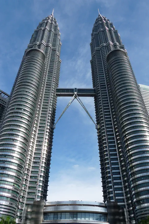
The Petronas Twin Towers in Kuala Lumpur, Malaysia, are two matching skyscrapers 452 meters tall, finished in 1998. Seen from above, each floor is shaped like an eight-pointed star, a pattern from Islamic art. A two-story skybridge joins them 170 meters above the ground, and from 1996 to 2003 they were counted as the tallest buildings in the world.
-
 Watch
Natural wonder
Komodo National Park
Komodo National Park, in Indonesia, is a group of rugged, dry islands between Sumbawa and Flores. Its three main islands, Komodo, Rinca and Padar, were made by volcanoes. The park contains most of the places where wild Komodo dragons, the largest living lizards, still live, along with rich coral reefs visited by turtles, dolphins and whales.
-
 Watch
City
Ho Chi Minh City
Ho Chi Minh City, once called Saigon, is Vietnam's largest city and the economic heart of the country. It lies on the Saigon River, north of the Mekong Delta. Since merging with two neighboring provinces in 2025, it has more than 14 million people, and in 2024 it opened its first metro line.
-
 Watch
Landmark
Angkor Wat
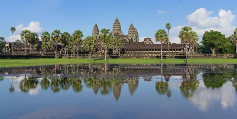
Angkor Wat, near the town of Siem Reap in Cambodia, was built in the 12th century by the Khmer king Suryavarman II. Britannica (2026) calls it the world's largest religious structure. It was built as a Hindu temple and later became a Buddhist place of worship.
-
Watch
Landmark
Angkor
Angkor, in northwestern Cambodia, was the capital of the Khmer Empire from the 9th to the 15th century. Its kings built city after city here, with scores of temples, such as Angkor Wat and the Bayon, and giant reservoirs and canals to water the rice fields. Today it covers about 400 square kilometers, and more than 100,000 people live in villages inside it.
-
 Watch
City
Bangkok
Bangkok, the capital of Thailand, lies on the delta of the Chao Phraya River, about 40 kilometers from the sea. It became the capital in 1782, when the new royal palace and temples were built. Once called the 'Venice of the East' for its canals, it is now a huge, busy city with skyscrapers and an elevated railway.
Explore next
-
 Watch
 Country
Indonesia
Indonesia is a country of about 17,500 islands in Southeast Asia, spread across the Equator between the Indian and Pacific oceans. It has more than 100 active volcanoes, rainforests full of wildlife, and about 286 million people (2025).
-
Watch
Landmark
Borobudur
Borobudur is a huge Buddhist monument in central Java, Indonesia, built about 1,200 years ago. It is shaped like a stepped pyramid around a small hill, with carved walls and 72 bell-shaped stupas on its round top terraces. For centuries it lay hidden under volcanic ash and plants, and today it is a UNESCO World Heritage Site.
-
Watch
City
Bangkok
Bangkok, the capital of Thailand, lies on the delta of the Chao Phraya River, about 40 kilometers from the sea. It became the capital in 1782, when the new royal palace and temples were built. Once called the 'Venice of the East' for its canals, it is now a huge, busy city with skyscrapers and an elevated railway.
-
Watch
City
Ho Chi Minh City
Ho Chi Minh City, once called Saigon, is Vietnam's largest city and the economic heart of the country. It lies on the Saigon River, north of the Mekong Delta. Since merging with two neighboring provinces in 2025, it has more than 14 million people, and in 2024 it opened its first metro line.
- Watch Geography Sea level The sea's surface moves up and down with waves and tides, so sea level means its average height. It is the zero we use to measure land: Mount Everest is about 8,849 meters above sea level. Satellites show that the global average sea level has risen about 10 centimeters since 1993, mostly because ice on land is melting and warming seawater takes up more room.
- Watch Geography Villages, towns and cities A place where people live together is called a settlement. A village is a small settlement, often in the countryside. A town is bigger than a village but smaller than a city. A city is a large place with many people, buildings, roads and jobs. In 2025, the United Nations reported that 45 percent of the world's people live in cities.
-
 Watch
City
Ankara
Ankara is the capital of Türkiye, in the interior of Anatolia, about 200 kilometers from the Black Sea. People have lived here since the Stone Age, and Romans, Byzantines, Seljuks and Ottomans all left buildings behind. It became the capital in 1923, and today it is a city of government, universities and museums.
-
 Watch
City
Baghdad
Baghdad, the capital of Iraq, stands on the Tigris River in the land once called Mesopotamia. It was founded in 762 as a round city, and for about 500 years it was one of the greatest cities in the world and a great center of learning, where scholars studied math, medicine and the stars. Today it is Iraq's largest city.
For parents & teachers
What children will learn
- Locate Jakarta on the north coast of Java in Indonesia.
- Trace how Jayakerta became Batavia and then Jakarta.
- Explain why a low, flat city near the sea can flood.
- Understand that Indonesia plans a new capital, Nusantara, and that Jakarta remains the capital until a presidential decree moves it.
Recommended ages: 3 to 17 · About 15 minutes
Talk about it
- Indonesia is building a new capital. What would a country need to move its government to a new city?
- Jakarta is built on low, flat land that was once swamp. What can a city do to protect itself from floods?
- Jakarta opened its first metro line in 2019. How might a new train line change a crowded city?
Try at home or in class
- In a tray, build a flat 'city' of blocks on sand near a 'sea' of water, then pour water from a cup upstream. Where does it go? Try adding channels or a wall.
- Draw a timeline strip with Jayakerta (1527), Batavia (1619), Djakarta (1945) and Jakarta, capital (1949).
Key vocabulary: capital, decree, megacity, kampong, becak, flood, MRT
Where these facts come from
- Wikidata , Wikimedia Foundation (CC0 1.0)
- Natural Earth vector data , Natural Earth (NACIS) (Public domain)
- Jakarta , Encyclopaedia Britannica
- Jakarta: Economy, transportation, administration and society , Encyclopaedia Britannica
- Jakarta: History , Encyclopaedia Britannica
- Ikhtisar Putusan Perkara Nomor 71/PUU-XXIV/2026 (summary of ruling, May 12, 2026) , Mahkamah Konstitusi Republik Indonesia (Constitutional Court of Indonesia)
- Constitutional Court Confirms Jakarta Still Indonesia's Capital, Not Nusantara , Jakarta Globe (May 13, 2026)
- Indonesia Confirms Nusantara as New Political Capital, Targeting 2028 Completion , Jakarta Globe (September 23, 2025)
- MRT & LRT Development , Jakarta Rendah Emisi (DKI Jakarta Environment Agency)
- Jakarta: climatological information , World Meteorological Organization, World Weather Information Service
- Jakarta Population Recorded at 11.01 Million , Berita Jakarta (Jakarta Provincial Government), December 15, 2025
- Wikimedia Commons , Wikimedia Foundation (Per file (public domain, CC0, CC BY or CC BY-SA); see each media record)
Checked, not yet human-reviewed. Last updated October 27, 2026. Spotted a mistake? Tell us.