 Country
South America
Colombia
Colombia is a country in South America. It has two seas, high mountains, hot rainforests and many, many kinds of birds.
Colombia is in the northwest of South America, with coasts on both the Caribbean Sea and the Pacific Ocean. Three ranges of the Andes run through it, and most people live in the cool mountains, where the capital, Bogotá, sits on a high plateau. About 53.4 million people lived there in 2026, according to DANE, the national statistics office.
Colombia lies near the Equator in northwestern South America, the only country in the Americas named for Christopher Columbus. The Andes split there into three parallel cordilleras, which hold most of the population, while the Llanos grasslands and the Amazon rainforest cover nearly two-thirds of the land. With about 53.4 million people (2026, DANE projection), it is the most populous country of Spanish-speaking South America.
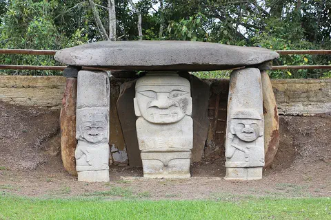
Photo: Bernard Gagnon, CC BY-SA 4.0, via Wikimedia Commons
Discover Colombia
Colombia is a country in South America.
It has two seas. Tall mountains run through the middle. The capital city is Bogotá. It is high up in the mountains.
Colombia is a country in the northwest of South America. It is the only country in the Americas named after Christopher Columbus. Its north coast faces the Caribbean Sea, and its west coast faces the Pacific Ocean.
The Andes mountains split into three long ranges as they run through Colombia, with two great river valleys between them. Most people live in these mountains, where the air is cooler. The capital, Bogotá, is on a high, flat plateau. About 53.4 million people lived in Colombia in 2026, and Spanish is the official language.
Colombia occupies the northwestern corner of South America, with about 1,600 km of Caribbean coast to the north and 1,300 km of Pacific coast to the west; Panama, which divides the two bodies of water, borders it to the northwest. Britannica describes it as more than twice the size of France, and Wikidata gives about 1.14 million square kilometers. The San Andrés y Providencia archipelago lies off the Nicaraguan coast, some 650 km from the mainland.
North of Ecuador, the Andes flare out into three parallel ranges, the Cordilleras Occidental, Central and Oriental, separated by the valleys of the Magdalena and Cauca rivers. The population is concentrated in this mountainous interior. DANE, the national statistics office, projects 53,399,171 people for 2026 (series updated in July 2025 from the 2018 census), about three-quarters of them in cabeceras, the main towns of each municipality, and more than a third of Colombians live in the six largest metropolitan areas, of which Bogotá is the largest.
Cities and famous places
Bogotá is the biggest city in Colombia.
It is high in the mountains, so it is cool there. Cartagena is by the sea. It has old walls and forts. Medellín sits in a deep mountain valley.
Bogotá, the capital, was founded in 1538 on a high plateau in the eastern Andes, about 2,600 meters above the sea. It is cool all year, with an average temperature of about 14 °C. Its Gold Museum holds a huge collection of gold objects made by skilled Indigenous craftspeople long ago.
Medellín, Colombia's second city, lies in a deep valley in the central mountains, and Cali is the third most populous city. On the Caribbean coast, Cartagena was one of the most important ports in the Caribbean. The Spanish built forts and a wall around it, starting in 1586.
Bogotá, founded by Gonzalo Jiménez de Quesada in 1538, stands on the Sabana de Bogotá in the Cordillera Oriental at an average of about 2,625 m by the city government's figure (Britannica gives 2,640 m), with an average temperature of 14 °C and about 223 days of precipitation a year. Bogotá, Medellín and Cali, all in the Andean region, are the three most populous cities; the Caribbean ports of Barranquilla, Cartagena and Santa Marta anchor the Atlantic lowlands, home to about a fifth of the population. Britannica describes the Gold Museum in Bogotá as holding the world's finest and largest collection of worked gold.
UNESCO inscribed Cartagena's port and fortifications in 1984 as the most extensive system of military fortifications in South America, begun by the Spanish in 1586 and extended in the 18th century. In the coffee region of the central Andes, the Coffee Cultural Landscape (2011) preserves farms on slopes steeper than 25 percent, shaped by Antioquian settlers who arrived in the 19th century and by farming ways passed down through the generations.

Mountains, plains and rainforest
Colombia has very high mountains.
Some mountains are volcanoes. Some have snow on top, even near the Equator. Low down, it is hot and green. In the east there are big grassy plains and a huge rainforest.
Colombia is close to the Equator, so the temperature hardly changes through the year. Instead, it changes with height: low land is hot, the middle slopes are mild and good for coffee, and the high mountains are cold. Above about 4,600 meters there is snow and ice all year.
The highest peaks are the twin summits of Cristóbal Colón and Simón Bolívar, 5,775 meters high, in the Santa Marta Mountains near the Caribbean. East of the Andes lie the Llanos, wide grassy plains, and the Amazon rainforest. In the high, misty páramo grow strange, hairy-leaved plants called frailejones.
Britannica explains the cordilleras as thrust up by the subduction of the Nazca Plate and, to the north, the Caribbean Plate beneath the South American Plate, a process that still causes frequent earthquakes. The Cordillera Central carries some 20 volcanoes of the past 2.6 million years, the highest being Mount Huila (5,750 m) and the Ruiz-Tolima complex; in November 1985 Ruiz erupted, its melting snow and ice sent mudflows downslope, and the town of Armero was destroyed with more than 25,000 deaths. The isolated Santa Marta massif reaches 5,775 m at Cristóbal Colón and Simón Bolívar, the country's highest point.
The climate is tropical and nearly seasonless; temperature falls about 0.6 °C per 100 m of height, giving the familiar zones of tierra caliente, tierra templada (the coffee zone, 900-2,000 m) and tierra fría (2,000-3,000 m). Above them, the páramo of tussock grasses and the frailejón (Espeletia, some 50 species) reaches its greatest development in Colombia. East of the Andes, the Llanos form the largest savanna complex in tropical America, and the Amazon rainforest reaches its northern limit.

Animals of Colombia
Colombia has so many birds.
It has many kinds of hummingbirds. Toucans live there too. Spectacled bears live in the forests. Jaguars and sloths live in the rainforest.
More than 1,500 kinds of birds live in Colombia, including toucans and many hummingbirds. Many birds live only in a narrow band of height on the mountainsides.
The forests of the Amazon and the Pacific coast are full of life: anteaters, sloths, monkeys, tapirs, capybaras, pumas and jaguars, and the spectacled bear, a bear of the Andes. Far out in the Pacific, the waters around Malpelo Island are a protected home for huge groups of sharks.
Britannica counts more than 1,500 bird species in Colombia, including toucans, the velvet-purple coronet and other hummingbirds, as well as migrants from North America; many species keep to narrow altitudinal bands. The forests of the Amazon and the Pacific Chocó hold anteaters, sloths, several monkey species, tapirs, peccaries, spectacled bears, agoutis, pacas and capybaras, with pumas and jaguars among the carnivores. Caimans, crocodiles, electric eels and earthworms up to about 1.8 m long also live there.
UNESCO lists Los Katíos National Park (1994) as the only place in South America where many Central American species occur, including the American crocodile, giant anteater and Central American tapir. Malpelo, about 500 km off the Pacific coast (inscribed 2006), protects the largest no-fishing zone in the Eastern Tropical Pacific, with major gatherings of hammerhead and silky sharks, 394 fish species and 17 marine mammal species.

People, languages and food
Spanish is the main language of Colombia.
Some Indigenous people speak their own languages too. Many people like to eat arepas. They are round corn cakes. Lots of people love football. Cumbia is a famous kind of dance music.
Spanish is the main language of Colombia, and there are also more than 180 Indigenous languages and dialects. Many Colombians have mixed European and Indigenous ancestors, and many families on the coasts are of African descent.
Arepas, flat round cakes made of cornmeal, are a common breakfast or afternoon snack, often with a spicy sauce called ají. Music mixes Indigenous, Spanish and African sounds, in styles such as cumbia and vallenato. Football is the most popular sport, and every year the Carnival of Barranquilla fills the city with dancers, drum music and masks.
Britannica describes the population as largely mestizo, of mixed European and Indigenous descent, with substantial minorities of European and African ancestry; people of African descent live mainly in the coastal departments and the sugar-growing Cauca valley, and most people on the Pacific coast descend from liberated Africans. Castilian Spanish is the official language, alongside more than 180 Indigenous languages and dialects in families such as Arawakan, Chibchan and Cariban. Most people are Roman Catholic, and the constitution guarantees religious freedom.
Arepas, cornmeal cakes, are a common breakfast or snack, often served with ají; on the Caribbean coast street vendors deep-fry them with an egg inside. Cumbia and vallenato are among the most distinctive musical styles, and the national instrument is the 12-stringed tiple. The Carnival of Barranquilla, held in the four days before Lent, was proclaimed by UNESCO in 2003 and inscribed in 2008. Football is the most widely played sport, and tejo, a game similar to quoits, derives from the Chibcha people. Gabriel García Márquez won the Nobel Prize for Literature in 1982.

A long history
People lived in Colombia a very long time ago.
They made big stone statues and deep tombs. They made beautiful things out of gold. Later, people came from Spain. In 1810, people in Bogotá began to break away from Spanish rule.
People have lived in Colombia for thousands of years. In San Agustín, in the southern Andes, ancient communities built earth mounds over stone tombs and carved large stone statues. At Tierradentro, people dug tombs deep into the rock and painted them in red, black and white between about 600 and 900 CE.
The Spanish arrived in the 1500s and founded cities such as Bogotá in 1538. On July 20, 1810, people in Bogotá rose up against Spanish rule, a day now celebrated as Independence Day. In 1819 Simón Bolívar's army won the Battle of Boyacá, a decisive defeat for the Spanish forces.
Complex chiefdom societies developed around San Agustín from about 1000 BCE; during the Regional Classic period (1-900 CE) they raised burial mounds up to 30 m across over stone tombs with large statues (UNESCO, 1995). Tierradentro's shaft-and-chamber tombs, up to 12 m wide and 7 m deep, were carved in volcanic tuff between 600 and 900 CE. At the Spanish conquest, Chibchan-speaking peoples were concentrated on the high plateau where Bogotá was founded in 1538.
The uprising in Bogotá on July 20, 1810, is commemorated as Independence Day. Bolívar defeated Spanish forces at Boyacá on August 7, 1819, and the Republic of Colombia, known as Gran Colombia, joined present-day Colombia, Panama, Venezuela and Ecuador until 1830. Rivalry between Liberals and Conservatives brought repeated civil wars between 1840 and 1903. From the 1970s, Britannica writes, violence fed by guerrilla insurgencies and the narcotics trade affected the country, and paramilitary groups also grew. After talks held largely in Havana, the government and the FARC guerrilla group signed a final peace agreement on September 26, 2016; voters narrowly rejected it in a plebiscite on October 2, and a renegotiated accord was ratified by Congress in late November. On August 15, 2017, the government declared an official end to its conflict with the FARC, while the ELN and FARC dissident groups continued to operate in parts of the country.

Colombia on the map
Find Colombia on the globe.
It is at the top of South America. One sea is to the north. A big ocean is to the west. Five countries are its neighbors.
Colombia is in the northwest corner of South America, close to the Equator. Panama is its neighbor to the northwest.
The Caribbean Sea lies to the north and the Pacific Ocean to the west. Venezuela and Brazil are to the east, and Peru and Ecuador are to the south. Out in the Caribbean, the islands of San Andrés and Providencia also belong to Colombia.
Colombia has land borders with five countries: Panama to the northwest, Venezuela and Brazil to the east, and Peru and Ecuador to the south. Its northern coastline of about 1,600 km faces the Caribbean, and its western coast of about 1,300 km faces the Pacific; the Baudó Mountains on the Pacific side are a southward extension of the Isthmus of Panama.
Britannica divides the country into five traditional regions: the Atlantic lowlands, the Pacific coast, the Andean region, the Llanos and the Amazonian rainforest. The eastern lowland runs about 1,000 km from the Arauca and Meta rivers south to the Putumayo, on the Peru-Ecuador border, and more than 650 km east from the Andes to the Orinoco-Negro river line. The arid La Guajira Peninsula is the northernmost point of the mainland.
- Caribbean coast
- about 1,600 km
- Pacific coast
- about 1,300 km
- San Andrés y Providencia
- about 650 km northwest of the mainland
- Highest point
- Cristóbal Colón and Simón Bolívar, 5,775 m
Amazing facts
-
Colombia is named after a sailor called Columbus.
Colombia is the only country in the Americas named after Christopher Columbus.
Britannica notes that Colombia is the only American nation named for Christopher Columbus.
-
More than 1,500 kinds of birds live in Colombia.
Colombia has more than 1,500 bird species, and many live only in a narrow band of height on the mountains.
Colombia's more than 1,500 bird species include toucans, the velvet-purple coronet and other hummingbirds; many are confined to narrow altitudinal bands.
-
Some earthworms in Colombia are very, very long.
Some earthworms in Colombia grow up to about 1.8 meters long.
Britannica lists earthworms up to six feet (about 1.8 m) long among Colombia's unusual species.
-
In Bogotá, it is cool all year.
Bogotá is so high up that its average temperature is only about 14 °C, even though it is near the Equator.
High on its Andean plateau, Bogotá averages 14 °C and has about 223 days with precipitation a year, though its yearly rainfall is scarcely 1,000 mm.
-
People in old Colombia made treasures out of gold.
The Gold Museum in Bogotá has a huge collection of gold objects made by Indigenous craftspeople.
Britannica describes the Gold Museum in Bogotá as possessing the world's finest and largest collection of worked gold.
Words to know
- cordillera
- a long chain of mountain ranges
- plateau
- a wide, flat area of high land
- páramo
- cold, misty grassland high in the mountains near the Equator
- subduction
- when one of Earth's plates slides down beneath another
- Llanos
- the wide grassy plains east of the Andes
- mestizo
- a person of mixed European and Indigenous descent
- World Heritage Site
- a place UNESCO lists as important to all people, to be protected
Discovery challenge
-
What is the capital city of Colombia?
Which city is the capital of Colombia?
Which city, founded in 1538 on a plateau in the Cordillera Oriental, is Colombia's capital?
- Cartagena
- Bogotá
- Medellín
Show the answer
Bogotá
Bogotá is the capital. It is high in the mountains.
Bogotá, the capital, sits on a high plateau about 2,600 meters above the sea.
Gonzalo Jiménez de Quesada founded Bogotá in 1538 on the Sabana de Bogotá; it is the largest of Colombia's metropolitan areas.
-
Colombia has a coast on the Caribbean Sea. Which ocean is on its other coast?
Colombia faces the Caribbean Sea to the north. Which ocean lies along its west coast?
Besides about 1,600 km of Caribbean shore, Colombia has about 1,300 km of coast on which ocean?
- The Pacific Ocean
- The Indian Ocean
- The Arctic Ocean
Show the answer
The Pacific Ocean
The Pacific Ocean is on Colombia's west side.
Colombia has coasts on both the Caribbean Sea and the Pacific Ocean, with Panama between them.
Colombia's 1,300-km western coast faces the Pacific; Panama, to the northwest, divides the two bodies of water.
-
Into how many long mountain ranges do the Andes split in Colombia?
How many parallel ranges do the Andes split into as they cross Colombia?
Into how many parallel cordilleras does the Andean system divide north of the Ecuadoran border?
- One
- Three
- Ten
Show the answer
Three
The Andes split into three ranges in Colombia.
The Andes split into three ranges, with the Magdalena and Cauca river valleys between them.
The Cordilleras Occidental, Central and Oriental are separated by the Magdalena and Cauca valleys.
-
Why is it cool in Bogotá, even near the Equator?
Bogotá is near the Equator. Why is it cool there all year?
What mainly sets the temperature zones (pisos térmicos) of Colombia, a country with almost no seasons?
- Snow blows in from the North Pole
- It is high up in the mountains
- The sun never shines there
Show the answer
It is high up in the mountains
Bogotá is high up in the mountains. High places are cooler.
Bogotá is about 2,600 meters high, and in Colombia the air gets cooler the higher you go.
Temperature falls about 0.6 °C per 100 m of ascent, so elevation, not season, defines tierra caliente, templada and fría.
-
Which bear lives in the mountain forests of South America?
Which bear lives in the forests of Colombia?
Which bear, Tremarctos ornatus, lives in the forests of Colombia's Amazon and Pacific Chocó regions?
- Polar bear
- Spectacled bear
- Giant panda
Show the answer
Spectacled bear
The spectacled bear lives there.
The spectacled bear lives in Colombia's forests, along with jaguars, sloths and tapirs.
Britannica lists spectacled bears among the animals of Colombia's Amazon and Chocó forests; Tremarctos ornatus is the only bear living south of the Equator.
Places to discover in Colombia
-
 Watch
City
Bogotá
Bogotá is the capital and largest city of Colombia, built on a high plain in the Andes, 2,625 meters above sea level. Founded by the Spanish in 1538 on land of the Muisca people, it is home to about 8 million people (2024) and a famous museum of ancient gold.
-
 Watch
Natural wonder
Amazon rainforest
The Amazon rainforest covers about 6 million square kilometers around the Amazon River and its branches in northern South America, and about 60 percent of it is in Brazil. Britannica calls it the world's richest and most varied home for living things, with millions of kinds of insects, plants and animals.
-
Watch
Natural wonder
Amazon River
The Amazon River flows from tiny streams in the Andes Mountains of Peru across Colombia and Brazil to the Atlantic Ocean. NASA calls it the largest river in the world: about 219,000 cubic meters of water pour into the ocean every second, nearly a fifth of all the water that rivers carry to the oceans.
-
 Watch
Natural wonder
Andes
The Andes run down the whole western side of South America, from the Caribbean coast to the continent's southern tip, through seven countries. Britannica measures them at about 8,900 kilometers, and their highest peak, Aconcagua, rises to 6,959 meters. They are still growing as one plate of Earth's crust slides under another, which is why the Andes have so many volcanoes and earthquakes.
Animals of Colombia
-
 Watch
Animal
Spectacled bear
The spectacled bear, or Andean bear, is the only bear that lives in South America. It is named for the pale markings that ring the eyes of many bears, like a pair of glasses. It lives in the forests of the Andes Mountains, climbs trees, builds platforms in branches and eats mostly fruit and bromeliads.
-
 Watch
3D
Animal
Jaguar
The jaguar is the largest cat in North and South America. It lives near rivers and swamps, swims well, and has such a powerful bite that it can crack a turtle's shell. Most jaguars live in the Amazon rainforest.
-
 Watch
3D
Animal
Keel-billed toucan
The keel-billed toucan lives in the forests of southern Mexico, Central America and northern South America. Its huge, colorful bill can be a third of its whole length, yet it is light, and the bird uses it to pick fruit from thin branches.
-
 Watch
Animal
Neon tetra
The neon tetra is a tiny fish, about as long as a quarter is wide, with a glowing blue stripe and a bright red patch. In the wild it lives in clear and dark-water forest streams of the western Amazon. It is also one of the most popular aquarium fish in the world.
-
 Watch
Animal
Boa constrictor
The boa constrictor is a large, heavy snake of South America. Of all the boas, it lives in the greatest variety of places, from rainforests to dry scrub and farms. It catches food by squeezing, it has no venom, and mothers give birth to live babies.
-
 Watch
Animal
Common basilisk
The common basilisk is a lizard of riversides and streams from Nicaragua to Venezuela. It climbs trees, swims well and, when it is startled, can sprint upright across the surface of the water on its big back feet before it sinks and swims.
-
 Watch
Animal
Leafcutter ant
Leafcutter ants are farmers. Workers cut pieces of leaves, carry them home along busy trails and use them to grow a fungus garden underground, and the fungus is their food. This page is about one well-known kind, Atta cephalotes, which lives in Central and South America in giant nests of hundreds of thousands to millions of ants.
-
 Watch
3D
Animal
Giant isopod
The giant isopod is a deep-sea relative of the pill bugs and sowbugs you find under garden stones, but it can grow to about 50 centimeters long. It crawls over the dark sea floor of the western Atlantic, cleaning up dead fish, squid and other food that sinks from above.
-
 Watch
3D
Animal
Golden poison frog
The golden poison frog is a small frog from one small area of rainforest in western Colombia. It comes in bright yellow, orange or mint green, and its skin holds a very strong poison that comes from the insects it eats. Scientists call it the most toxic of all frogs. It is endangered because its forest is being cleared.
-
 Watch
Animal
Christmas tree worm
The Christmas tree worm is a small sea worm that lives in a tube inside living coral on Caribbean reefs. Only its two colorful, spiral crowns show. They catch tiny floating food and help it breathe, and the worm pulls them in with a flash if anything comes too close.
-
 Watch
3D
Animal
Green iguana
The green iguana is a large lizard from the forests of Central and South America. It climbs high into trees to bask in the sun, eats leaves, flowers and fruit, and dives into rivers to get away from danger. It can grow to about 2 meters long, tail included.
Explore next
-
Watch
City
Bogotá
Bogotá is the capital and largest city of Colombia, built on a high plain in the Andes, 2,625 meters above sea level. Founded by the Spanish in 1538 on land of the Muisca people, it is home to about 8 million people (2024) and a famous museum of ancient gold.
-
Watch
Natural wonder
Amazon rainforest
The Amazon rainforest covers about 6 million square kilometers around the Amazon River and its branches in northern South America, and about 60 percent of it is in Brazil. Britannica calls it the world's richest and most varied home for living things, with millions of kinds of insects, plants and animals.
-
Watch
Animal
Spectacled bear
The spectacled bear, or Andean bear, is the only bear that lives in South America. It is named for the pale markings that ring the eyes of many bears, like a pair of glasses. It lives in the forests of the Andes Mountains, climbs trees, builds platforms in branches and eats mostly fruit and bromeliads.
-
Watch
3D
Animal
Jaguar
The jaguar is the largest cat in North and South America. It lives near rivers and swamps, swims well, and has such a powerful bite that it can crack a turtle's shell. Most jaguars live in the Amazon rainforest.
- Watch Geography Tectonic plates Earth's hard outer shell is cracked into a dozen or so giant pieces called tectonic plates. They carry the continents and oceans and move a few centimeters a year. Where plates pull apart, push together or slide past each other, we find volcanoes, mountains and earthquakes.
-
Watch
3D
Animal
Keel-billed toucan
The keel-billed toucan lives in the forests of southern Mexico, Central America and northern South America. Its huge, colorful bill can be a third of its whole length, yet it is light, and the bird uses it to pick fruit from thin branches.
-
Watch
Animal
Neon tetra
The neon tetra is a tiny fish, about as long as a quarter is wide, with a glowing blue stripe and a bright red patch. In the wild it lives in clear and dark-water forest streams of the western Amazon. It is also one of the most popular aquarium fish in the world.
-
Watch
Animal
Boa constrictor
The boa constrictor is a large, heavy snake of South America. Of all the boas, it lives in the greatest variety of places, from rainforests to dry scrub and farms. It catches food by squeezing, it has no venom, and mothers give birth to live babies.
For parents & teachers
What children will learn
- Locate Colombia, its two coasts and its five neighbors.
- Explain why temperature in Colombia depends on height rather than season.
- Describe some of Colombia's wildlife, places and ways of life without treating them as one single culture.
- Outline Colombia's history from San Agustín to independence and today.
Recommended ages: 3 to 17 · About 15 minutes
Talk about it
- Why do you think most people in Colombia live in the mountains rather than on the hot plains?
- Music in Colombia mixes Indigenous, Spanish and African sounds. What mixes of foods or music do you know?
- How might a coffee farmer's day on a steep mountain slope be different from a farmer's day on flat land?
Try at home or in class
- Draw a tall mountain and color bands for hot, mild, cold and snowy zones, then place a coffee bush, a city like Bogotá and the snow line in the right bands.
- Make arepa-shaped cakes from play dough and count how many shapes of corn foods your family knows.
Key vocabulary: cordillera, plateau, páramo, subduction, Llanos, mestizo, World Heritage Site
Where these facts come from
- Wikidata , Wikimedia Foundation (CC0 1.0)
- Natural Earth vector data , Natural Earth (NACIS) (Public domain)
- UNESCO World Heritage List , UNESCO World Heritage Centre (Linked as a reference; site facts come from Wikidata)
- Colombia (introduction and Land) , Encyclopaedia Britannica
- Colombia: Climate , Encyclopaedia Britannica
- Colombia: Plant and animal life , Encyclopaedia Britannica
- Colombia: Settlement patterns, Languages, Ethnic groups, Religion , Encyclopaedia Britannica
- Colombia: Sports and recreation; history before the conquest , Encyclopaedia Britannica
- Colombia: The arts and cultural institutions , Encyclopaedia Britannica
- Colombia: Revolution and independence , Encyclopaedia Britannica
- Colombia in the 21st century , Encyclopaedia Britannica
- Arepa , Encyclopaedia Britannica
- Proyecciones de población por área geográfica, nacional, 2018-2070 (actualizado 18 de julio de 2025) , DANE (Departamento Administrativo Nacional de Estadística)
- Bogotá (historico Alcaldía) , Alcaldía Mayor de Bogotá
- Colombia: The growth of drug trafficking and guerrilla warfare , Encyclopaedia Britannica
- San Agustín Archaeological Park , UNESCO World Heritage Centre
- National Archeological Park of Tierradentro , UNESCO World Heritage Centre
- Port, Fortresses and Group of Monuments, Cartagena , UNESCO World Heritage Centre
- Coffee Cultural Landscape of Colombia , UNESCO World Heritage Centre
- Los Katíos National Park , UNESCO World Heritage Centre
- Malpelo Fauna and Flora Sanctuary , UNESCO World Heritage Centre
- Carnival of Barranquilla , UNESCO Intangible Cultural Heritage
- PlayOwl region table, version 1 , PlayOwl (PlayOwl original data)
- flag-icons 7.5.0 , Panayiotis Lipiridis and contributors (MIT)
- Wikimedia Commons , Wikimedia Foundation (Per file (public domain, CC0, CC BY or CC BY-SA); see each media record)
Checked, not yet human-reviewed. Last updated October 24, 2026. Spotted a mistake? Tell us.
Picture credits
- Photo: Bernard Gagnon, CC BY-SA 4.0, via Wikimedia Commons · source · license
- Photo: Bernard Gagnon, CC BY-SA 4.0, via Wikimedia Commons · source · license
- Photo: Johan Huertas, CC BY-SA 4.0, via Wikimedia Commons · source · license
- Photo: Neil Palmer/CIAT, CC BY-SA 2.0, via Wikimedia Commons · source · license
- Photo: Luis90f, CC BY-SA 4.0, via Wikimedia Commons · source · license
- Photo: inyucho, CC BY 2.0, via Wikimedia Commons · source · license
- Photo: Felipe Restrepo Acosta, CC BY-SA 3.0, via Wikimedia Commons · source · license
- Photo: Andrew Hyde, CC BY 2.0, via Wikimedia Commons · source · license