
Natural wonder Australia and Oceania
Milford Sound / Piopiotahi
Milford Sound is a long arm of the sea in New Zealand. Steep mountains rise straight up from the water. One pointy mountain is called Mitre Peak.
Milford Sound / Piopiotahi is a fiord in Fiordland National Park, in the south-west of New Zealand's South Island. Glaciers carved its steep valley, and the sea filled it. It stretches 16 kilometers to the open sea, and Mitre Peak rises 1,692 meters straight from the water. It is one of the wettest places in New Zealand.
Milford Sound / Piopiotahi, in the north-west of Fiordland National Park, is a glacially carved fiord 16 km long and up to 265 m deep, part of the Te Wāhipounamu – South West New Zealand World Heritage Area (1990). With up to 7 m of rain a year, a permanent tea-stained freshwater layer sits on the seawater, and deep-water animals such as black coral grow within diving depth; the 690 ha Piopiotahi Marine Reserve has protected its northern side since 1993.
Photo: W. Bulach, CC BY-SA 4.0, via Wikimedia Commons
Discover Milford Sound / Piopiotahi
Milford Sound is in New Zealand.
It is a long, deep arm of the sea between tall mountains. The mountains are very steep, and forest grows on them. Boats take visitors out on the water.
Milford Sound / Piopiotahi is in the north-west of Fiordland National Park, in the south-west of New Zealand's South Island. It is a fiord: a long, narrow arm of the sea in a valley carved by glaciers. It stretches 16 kilometers to the open sea and is 265 meters deep in places.
The Department of Conservation calls Mitre Peak, whose sheer walls rise 1,692 meters straight from the water, one of the most recognized and photographed peaks in the world. Visitors reach the fiord by the Milford Road, 120 kilometers from the town of Te Anau.
Milford Sound / Piopiotahi lies in the north-west of Fiordland National Park and of the Te Wāhipounamu – South West New Zealand World Heritage Area, inscribed in 1990 under criteria (vii)–(x). UNESCO describes that 2.6 million ha property as about 10% of New Zealand's land, shaped by successive glaciations into fiords, rocky coasts, cliffs, lakes and waterfalls, with 15 fiords indenting the Fiordland coast.
The Department of Conservation (DOC) gives the sound's length as 16 km to the open sea and its depth as up to 265 m, and Mitre Peak's sheer walls as rising 1,692 m directly from the water. The fiord is reached by the Milford Road (State Highway 94), 120 km from Te Anau, through the Homer Tunnel.
- Country
- New Zealand (Fiordland National Park)
- Length
- 16 km to the open sea
- Depth
- up to 265 m
- Mitre Peak
- 1,692 m
- World Heritage Site
- since 1990 (Te Wāhipounamu)
Carved by ice
Long ago, rivers of ice called glaciers filled these valleys.
The ice scraped the rock and made deep valleys with steep sides. When the ice melted, the sea came in.
DOC explains that the U-shaped valleys and steep, bare walls around Milford Sound were made by glaciers grinding and rounding the hard Fiordland rock, such as gneiss, diorite and granite. UNESCO says the whole region was shaped by one glaciation after another.
The mountains keep going down under the water, to depths of up to 265 meters. Near the Homer Tunnel on the road in, the ice carved a cirque, a steep-walled bowl like an amphitheater.
Per DOC, the Milford Road begins on ridges of rock debris left at the side of the glacier that once filled Lake Te Anau, and the U-shaped valleys and sheer walls of hard Fiordland rock (gneiss, diorite, granite) were formed by glacial grinding and rounding; just before the Homer Tunnel the road enters a cirque basin. Under the water the mountains continue to depths of up to 265 m.
UNESCO's statement describes Te Wāhipounamu as showing classic examples of the tectonic, climatic and glacial processes that shape Earth: the Alpine Fault, the contact zone of the Indo-Australian and Pacific plates, divides the region, and glaciation, past and present, dominates the landscape.
Rain, tea-colored water and black coral
It rains a lot at Milford Sound.
Rainwater flows into the sea and floats on top. It is brown like tea. Under it, special sea animals grow on the rock walls.
Milford Sound is one of the wettest places in New Zealand, with up to 7 meters of rain a year. So much fresh water pours in that it makes a permanent layer floating on top of the salty sea. Material washed out of the forest stains this layer the color of tea.
Below it, in a band 40 meters thick, unusual sea life grows on and around the sheer rock walls. DOC says divers come here to see black coral, which Fiordland's fiords are famous for.
DOC: very high rainfall, up to 7 m a year, creates a permanent freshwater layer on the sea surface, stained a tea color by material washed out of the forest. Below it a concentrated 40 m band of unusual marine life grows on and around the sheer rock walls.
On the inner northern wall, deep-water invertebrates fixed to the rock dominate: encrusting tubeworms, sponges, soft corals, colonial sea squirts, black coral and anemones. The Piopiotahi Marine Reserve is one of the most popular places in Fiordland to dive and see the black corals for which the fiords are famous.
Fish, dolphins, kea and beech forest
Seals, octopus and fish live in the water. Sometimes dolphins swim by.
Ferns and mosses grow in the wet forest. A cheeky mountain parrot called the kea lives near the road tunnel.
Divers in the marine reserve may see stingrays, crayfish, octopus, seals, sharks and more than 100 other kinds of fish. Toward the open sea, divers are often surrounded by schools of butterfly perch, and a few bottlenose dolphins live there too.
On land, tree ferns, mosses and ferns thrive in the wet forest of silver beech. Kea, New Zealand's mountain parrots, are often seen around the Homer Tunnel, and DOC warns that they are cheeky, so watch your belongings!
The 690 ha Piopiotahi Marine Reserve (1993) runs 16 km along the northern side of the sound, from Milford Sound village to Dale Point at the Tasman Sea, over mostly deep muddy basin, a large section of deep reef and a small strip of shallow rock wall. Divers may meet stingrays, crayfish, octopus, seals, sharks and more than 100 other fish species; toward the sea there are schools of butterfly perch, hundreds of rock lobster and occasional bottlenose dolphins.
On the descent to the sound, occasional rimu rise above silver beech, with tree ferns, shrubs, mosses and ferns. Kea are often seen around the Homer Tunnel, and the rare rock wren lives among boulders nearby. UNESCO notes that the World Heritage Area is home to the kea and the endangered takahē.
Greenstone, sealers and a long tunnel
Long ago, Māori people came here to gather a green stone.
Later, a sailor gave the fiord its English name. Today a road and a tunnel lead visitors there.
The Māori name Piopiotahi means "one native thrush", after the piopio, a bird now thought to be extinct. Early Māori gathered greenstone here and carried it away by sea or along an inland route over what is now the Milford Track.
The English name came from a Welsh sealing captain, John Grono, who named it after his birthplace, Milford Haven. In 1878 a Scottish sealer, Donald Sutherland, built three thatched huts here. Work on the Homer Tunnel, which carries the road through the mountains, began in 1935 and was finished in 1954.
DOC records that early Māori gathered kokotakiwai (greenstone) here, moving it mainly by sea to Murihiku (Southland) or inland over Omanui (McKinnon Pass) along the line of today's Milford Track; permanent settlements lay in the Hollyford Valley and around lakes Manapōuri and Te Anau. The name Piopiotahi means "one native thrush", after the piopio, which declined after mammal predators were introduced and is now thought to be extinct.
The sealing captain John Grono named the sound after his birthplace, Milford Haven in Wales. Donald Sutherland, its first European resident, built three thatched huts in 1878; with Quintin Mackinnon he later cut the Milford Track. William Homer found the Homer Saddle in 1889, and the Homer Tunnel, begun in 1935 and delayed by difficult conditions and the Second World War, was completed in 1954.
Visiting safely
People drive a long road to get there. Then they walk by the water or take a boat.
Bring a raincoat. Stay with a grown-up near the water.
The Milford Road from Te Anau takes about two hours to drive without stops. Weather, rock falls and, in winter, snow and avalanches can close the road or cause delays, so check before you go. Drones are not allowed without a permit.
The short Milford Foreshore Walk is an easy, wheelchair-friendly loop through beech forest and along the shore, with some of the best views of Mitre Peak. There may be a lot of sandflies on the walk!
DOC advises allowing about 2 hours for the Milford Road without stops, expecting closures and delays from weather, rock falls and winter snow and avalanches, and checking the road status first; freedom camping within 200 m of the road is not allowed, and drones need a permit. Te Anau is the nearest town with facilities.
DOC also notes that a large earthquake or tsunami is extremely unlikely during a visit but would leave few options: drop, cover and hold during shaking, and if it is long or strong, or a landslide is seen or heard, move up and away from the water.
Amazing facts
-
The fiord's Māori name is about a bird.
Piopiotahi means "one native thrush". The piopio was a ground-feeding bird that is now thought to be extinct.
Piopiotahi means 'one native thrush'; the piopio, a ground-feeding bird, declined rapidly after stoats and rats were introduced and is now thought to be extinct (DOC).
-
Up to 7 meters of rain can fall here in one year!
Up to 7 meters of rain can fall in a year around Milford Sound, making it one of the wettest areas in New Zealand.
With up to 7 m of rain a year, the area is among the wettest in New Zealand; the rain feeds a permanent freshwater layer on the fiord.
-
Kea parrots near the road are cheeky. Watch your things!
Kea, New Zealand's mountain parrots, are often seen around the Homer Tunnel. DOC says they are very cheeky, so keep an eye on your belongings.
Kea are often seen around the Homer Tunnel, and DOC warns visitors to watch their belongings; UNESCO notes the World Heritage Area is home to the kea.
-
The fiord got its English name from a place in Wales.
The sealing captain John Grono named Milford Sound after his birthplace, Milford Haven in Wales.
Welsh sealing captain John Grono named the sound after his birthplace, Milford Haven; DOC uses the dual name Milford Sound/Piopiotahi.
Words to know
- fiord
- a long, deep, narrow arm of the sea between steep cliffs, in a valley carved by a glacier (also spelled fjord)
- glacier
- a huge, slow-moving river of ice
- cirque
- a bowl-shaped hollow with steep sides, carved by ice high on a mountain
- marine reserve
- a protected area of sea where the sea life is looked after
- greenstone
- a green stone that early Māori gathered in Fiordland and carried away by sea or over the mountains
- black coral
- a coral that usually lives in deep water; in Milford Sound it grows within diving depth
Discovery challenge
-
What made the deep valley of Milford Sound?
What carved the valley of Milford Sound?
Which process shaped the U-shaped valleys and sheer walls of Milford Sound?
- Glaciers
- A volcano
- Wind
Show the answer
Glaciers
Rivers of ice called glaciers.
Glaciers ground the hard rock into a deep valley; then the sea flowed in.
Glacial grinding and rounding of hard Fiordland rock during successive glaciations.
-
What color is the top layer of water?
Why is the top layer of water in Milford Sound the color of tea?
What forms the permanent tea-colored surface layer in Milford Sound?
- Rainwater stained by the forest
- Paint from boats
- Sand from the beach
Show the answer
Rainwater stained by the forest
Brown like tea, from the forest.
Heavy rain makes a fresh layer, stained by material washed from the forest.
Very high rainfall forms a permanent freshwater layer stained by material washed out of the forest.
-
What special sea animal grows on the rock walls?
Which animal are the Fiordland fiords famous for?
Which deep-water animal draws divers to the Piopiotahi Marine Reserve?
- Black coral
- Penguins
- Jellyfish
Show the answer
Black coral
Black coral.
Black coral, which grows on the rock walls under the freshwater layer.
Black coral, for which the fiords are famous.
-
The Māori name Piopiotahi is about what?
What does the Māori name Piopiotahi mean?
What is the meaning of Piopiotahi, and what happened to the piopio?
- A bird, the native thrush
- A fish
- A mountain
Show the answer
A bird, the native thrush
A bird called the piopio.
"One native thrush", after the piopio bird.
'One native thrush'; the piopio is now thought to be extinct after predators were introduced.
-
What can close the road to Milford Sound?
What can close the Milford Road?
What causes closures and delays on the Milford Road, according to DOC?
- Bad weather, rock falls and avalanches
- Too many birds
- Low tide
Show the answer
Bad weather, rock falls and avalanches
Bad weather and falling rocks or snow.
Weather, rock falls and, in winter, snow and avalanches.
Weather, rock falls and winter snow and avalanches; check SH94 status before travel.
Nearby places
-
 Watch
Natural wonder
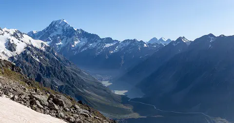
Aoraki / Mount Cook
Aoraki / Mount Cook is New Zealand's highest mountain, in the Southern Alps of the South Island. Its name joins its Māori name, Aoraki, with its English name, Mount Cook. The mountain is being pushed up where two of Earth's plates meet, and glaciers carve the valleys around it. In 2013 surveyors measured it at 3,724 meters.
-
 Watch
Natural wonder
South Island
The South Island of New Zealand sits where two of Earth's tectonic plates meet. Their collision built the Southern Alps, which rise to nearly 4,000 meters close to the sea. Glaciers carved its fiords and lakes, and its southwest is a World Heritage area full of rare birds.
-
 Watch
Natural wonder
Southern Alps / Kā Tiritiri o te Moana
The Southern Alps / Kā Tiritiri o te Moana stretch hundreds of kilometers along New Zealand's South Island. Two of Earth's plates push together here, along the Alpine Fault, and NASA says the mountains should keep rising over time.
-
 Watch
City
Christchurch
Christchurch is the main city of New Zealand's South Island. Universalis says English settlers founded it in 1850 on the wide Canterbury Plains, a few kilometers from the east coast. Its port, Lyttelton, lies beyond the Port Hills. About 407,800 people lived in the Christchurch urban area in mid-2025.
-
 Watch
Landmark
Te Papa
Te Papa, the Museum of New Zealand, opened on Cable Street in Wellington on 14 February 1998. Its name means 'container of treasures'. The building stands on soft land near a major fault line, so it sits on 152 base isolators that let it move gently in an earthquake.
-
 Watch
Natural wonder
Mount Ruapehu
Mount Ruapehu, at 2,797 meters, is the highest mountain in New Zealand's North Island and an active volcano. A crater lake fills its vent, and DOC says lahars, fast volcanic mudflows, are its main volcanic hazard.
-
 Watch
Natural wonder
Tongariro National Park
Tongariro National Park, in the middle of New Zealand's North Island, is the country's oldest national park. At its heart are three active volcanoes: Ruapehu, Tongariro and Ngāuruhoe. The mountains are important to the Māori people of the area, and UNESCO lists the park as a World Heritage Site for both its nature and its culture.
-
 Watch
Natural wonder
Lake Taupō
Lake Taupō, in the center of New Zealand's North Island, is the country's largest lake. It fills the caldera of Taupō volcano, which last erupted over 1,800 years ago.
Explore next
-
Watch
 Country
New Zealand
New Zealand, also called Aotearoa, is an island country in the South Pacific. Its two main islands have snowy mountains, glaciers, volcanoes and deep fiords, and about 5.36 million people lived there in 2026.
-
 Watch
Natural wonder
Geirangerfjord
Geirangerfjord is a fjord in western Norway: a long, deep, narrow arm of the sea between steep mountain walls, carved by glaciers in the Ice Age. It stretches 15 kilometers from Hellesylt to the village of Geiranger, with waterfalls pouring down its sides. Since 2005 it has been a UNESCO World Heritage Site together with Nærøyfjord.
-
Watch
Natural wonder
Aoraki / Mount Cook
Aoraki / Mount Cook is New Zealand's highest mountain, in the Southern Alps of the South Island. Its name joins its Māori name, Aoraki, with its English name, Mount Cook. The mountain is being pushed up where two of Earth's plates meet, and glaciers carve the valleys around it. In 2013 surveyors measured it at 3,724 meters.
-
Watch
Natural wonder
Tongariro National Park
Tongariro National Park, in the middle of New Zealand's North Island, is the country's oldest national park. At its heart are three active volcanoes: Ruapehu, Tongariro and Ngāuruhoe. The mountains are important to the Māori people of the area, and UNESCO lists the park as a World Heritage Site for both its nature and its culture.
- Watch Geography Glaciers A glacier is a huge mass of ice and snow that slowly flows over land. It forms where more snow falls than melts, year after year, until the snow is squeezed into ice. Pulled by its own weight, it creeps downhill, carving wide valleys and carrying rocks along.
- Watch Geography What is a World Heritage Site? World Heritage Sites are places so important that they belong, in a way, to everyone. Under a 1972 agreement, countries nominate their most outstanding places, experts check them, and a UNESCO committee decides. By 2026 the list held 1,273 sites: cultural places like the Taj Mahal, natural places like the Galápagos, and mixed ones like Machu Picchu.
-
Watch
Natural wonder
South Island
The South Island of New Zealand sits where two of Earth's tectonic plates meet. Their collision built the Southern Alps, which rise to nearly 4,000 meters close to the sea. Glaciers carved its fiords and lakes, and its southwest is a World Heritage area full of rare birds.
-
 Watch
Natural wonder
Sognefjord
The Sognefjord in western Norway is 205 kilometers long and 1,303 meters deep at its deepest point. Store norske leksikon, Norway's national encyclopedia, calls it Norway's longest and deepest fjord.
For parents & teachers
What children will learn
- Locate Milford Sound / Piopiotahi in Fiordland, New Zealand.
- Explain how glaciers and the sea make a fiord.
- Describe why fresh water floats on the sea in the fiord and what lives below it.
- Describe how people have traveled to and protected the fiord.
Recommended ages: 3 to 17 · About 15 minutes
Talk about it
- Why do you think a place with so much rain has such steep waterfalls and thick forest?
- The fiord has two names, one English and one Māori. Why might a place have two names?
- Why would people protect an area of sea as a marine reserve? How could that help the animals there?
Try at home or in class
- Fill a clear glass halfway with salty water, then very gently pour weak tea on top over the back of a spoon. Watch the fresh tea float on the salt water, like the fiord's top layer.
- Push an ice cube through a tray of damp sand to carve a U-shaped valley, then pour water in to make a model fiord.
Key vocabulary: fiord, glacier, cirque, marine reserve, greenstone, black coral
Where these facts come from
- Wikidata , Wikimedia Foundation (CC0 1.0)
- UNESCO World Heritage List , UNESCO World Heritage Centre (Linked as a reference; site facts come from Wikidata)
- Te Wahipounamu – South West New Zealand , UNESCO World Heritage Centre
- Milford Road/Milford Sound area: Fiordland National Park , Department of Conservation, New Zealand
- Nature and conservation: Milford Road/Milford Sound area , Department of Conservation, New Zealand
- Piopiotahi (Milford Sound) Marine Reserve , Department of Conservation, New Zealand
- Milford Foreshore Walk , Department of Conservation, New Zealand
- Wikimedia Commons , Wikimedia Foundation (Per file (public domain, CC0, CC BY or CC BY-SA); see each media record)
Checked, not yet human-reviewed. Last updated November 1, 2026. Spotted a mistake? Tell us.