
City Australia and Oceania
Christchurch
Christchurch is a big city in New Zealand. It sits on a wide, flat plain near the sea, with hills on one side.
Christchurch is the main city of New Zealand's South Island. Universalis says English settlers founded it in 1850 on the wide Canterbury Plains, a few kilometers from the east coast. Its port, Lyttelton, lies beyond the Port Hills. About 407,800 people lived in the Christchurch urban area in mid-2025.
Christchurch, the South Island's main city (Universalis), was founded in 1850 by English settlers on the Canterbury Plains, a few kilometers from the east coast. Stats NZ provisional estimate for 30 June 2025: 407,800 in the urban area, New Zealand's second-largest.
Photo: P. Stalder, CC BY-SA 3.0, via Wikimedia Commons
Discover Christchurch
Christchurch is a city in New Zealand. It is on the South Island.
It is the biggest city on that island.
Christchurch is the main city of the South Island of New Zealand. Universalis says it lies on the wide Canterbury Plains, a few kilometers from the east coast, and that English settlers founded it in 1850.
Stats NZ, New Zealand's statistics office, estimated 407,800 people in the Christchurch urban area on 30 June 2025, more than in any other New Zealand urban area except Auckland.
Universalis: the principal city of the South Island and New Zealand's second city, at the outlet of the Canterbury Plain a few kilometers from the east coast; founded in 1850 by English colonists; a grid-plan city around its central square.
Stats NZ estimates via City Population (Christchurch urban area, 30 June): 315,800 (1996), 350,300 (2006), 345,500 (2013), 372,500 (2018), 396,100 (2023), 407,800 (2025, provisional); rank 2 after Auckland (1,547,200).
- Country
- New Zealand (Canterbury region, South Island)
- People in the Christchurch urban area (provisional estimate, 30 June 2025)
- 407,800
- Rank
- New Zealand's second-largest urban area (2025 estimates)
- Founded
- 1850, by English settlers (Universalis)
A city on a plain below the mountains
This picture was taken from a hill. The city spreads out across flat land. Far away, there are mountains with snow on top.
This photo was taken from the Port Hills in September 2006. Large flat roofs, a railway line and green fields fill the front. Behind them, buildings and trees spread across the flat land, with a cluster of taller buildings in the middle, and snowy mountains rise far beyond. The city center may look different today.
Universalis says the city's homes, mostly houses with gardens, spread far across the plain.
Commons: 'Christchurch City (New Zealand) from the Port Hills', own work by P. Stalder, September 2006, GFDL and CC BY-SA 3.0 (also older CC BY-SA versions); categories: Cityscapes of Christchurch, 2006 in Christchurch.
Universalis: residential districts of detached houses with gardens spread widely across the plain and reach the first volcanic hills of Banks Peninsula. Wikidata: Hagley Park (Q1134612), a 164.6-hectare park, 1.30 km W of the city point.
- Photo
- Christchurch from the Port Hills, September 2006
- Hagley Park
- a 164.6-hectare park in Christchurch (Wikidata)
- University of Canterbury
- founded in 1873, with Gothic buildings in a park (Universalis)
A grid town from 1850
Christchurch was started in 1850 by people who came from England. Its streets were laid out in straight lines, like a checkerboard.
Universalis says English settlers founded Christchurch in 1850. The town was laid out as a grid of straight streets, like a checkerboard, around a central square that is still its heart.
The University of Canterbury was founded in 1873. Its Gothic-style buildings stand in a park, and Universalis says the university encouraged many high-technology companies to start in the city.
Universalis: founded in 1850 by English colonists; the square at the center of a checkerboard (grid) city remains its heart; the University of Canterbury, founded in 1873, spreads its Gothic buildings through a park and has encouraged the creation of many high-technology industries.
Stats NZ estimates via City Population (urban area): 324,800 (2001), 350,300 (2006), 345,500 (2013), 396,100 (2023).
- 1850
- founded by English settlers (Universalis)
- Street plan
- a grid around a central square (Universalis)
- 1873
- the University of Canterbury was founded (Universalis)
Tunnels to the port
Christchurch's ships use a port on the other side of some hills. Cars and trains go through tunnels to get there.
Christchurch's port is at Lyttelton, about 11 kilometers to the southeast, in a sheltered bay on the north side of the volcanic hills of Banks Peninsula. Universalis says road and railway tunnels run through the Port Hills to link the port with the city.
The port's trade in Universalis's account included wool, meat, dairy products, timber and grain going out, and fuel, fertilizer and steel coming in.
Universalis: Christchurch's outlet to the sea is the port of Lyttelton, 11 km southeast, at the head of a well-sheltered bay cut into the northern flank of the Banks volcanic massif; the port is linked to Christchurch by road and rail tunnels through the Port Hills; its freight was mainly exports of wool, meat, dairy products, timber and grain and imports of petroleum products, fertilizer, iron ore and steel.
Wikidata (from the city point Q79990): Port Hills (Q941581) 7.86 km SSE; Lyttelton Harbour/Whakaraupō (Q1879040) 12.01 km SE.
- Port
- Lyttelton, about 11 km southeast, in a sheltered bay (Universalis)
- Tunnels
- a road tunnel and a railway tunnel through the Port Hills (Universalis)
- Port Hills
- a range of hills about 7.9 km from the city's Wikidata point (Wikidata)
Mild summers and cool winters
Christchurch has warm summers and chilly winters. Summer comes in January there, and winter in July!
In the World Meteorological Organization's averages for Christchurch for 1981 to 2010, the average daily high is 22.6 °C in January and 10.9 °C in July. On July nights the average low is just 0.6 °C.
Christchurch gets about 594 millimeters of rain in a year. Every month gets between 35.9 and 64.7 millimeters; July is the wettest and January the driest.
WMO World Weather Information Service, Christchurch (43.47° S, 172.52° E; New Zealand National Meteorological Service), temperature and precipitation 1981–2010: mean daily maximum 10.9 °C (July) to 22.6 °C (January); mean daily minimum 0.6 °C (July) to 11.9 °C (January). Precipitation sums to 593.8 mm; July (64.7 mm) is the wettest month and January (35.9 mm) the driest. The table gives no rain-day counts.
- Average daily highs (WMO, Christchurch, 1981–2010)
- 10.9 °C (July) to 22.6 °C (January)
- Average daily lows (same table)
- 0.6 °C (July) to 11.9 °C (January)
- Rain in a year (sum of the monthly averages)
- about 594 mm
Universities, factories and farms
Christchurch has many factories. Students go to a big university there. The city has a very large park, too.
Universalis calls Christchurch New Zealand's second industrial center. Its factories have included food plants that freeze meat for export, and makers of textiles, glass and chemicals, and the university has helped high-technology companies grow.
The city also has room to play: Hagley Park covers 164.6 hectares, about the size of 230 soccer fields.
Universalis: the country's second industrial center: food industries (many meat-freezing plants for export), textiles, glass and chemical industries; the University of Canterbury has encouraged many high-technology industries.
Wikidata: University of Canterbury (Q432475), public research university, 4.45 km W of the city point; Hagley Park (Q1134612), 164.6 ha, 1.30 km W. A soccer field of about 0.71 ha (105 m by 68 m) fits about 230 times into 164.6 ha.
- Industry
- New Zealand's second industrial center, with food processing such as meat freezing (Universalis)
- University of Canterbury
- a public research university (Wikidata), founded 1873 (Universalis)
- Hagley Park
- 164.6 hectares (Wikidata)
Christchurch on the map
Find New Zealand on the globe. It has two big islands. Christchurch is on the east side of the bottom one.
Christchurch lies at about 43.5° south and 172.6° east, near the east coast of New Zealand's South Island.
Measured from the city's center point on Wikidata, Hagley Park is about 1.3 kilometers west, the University of Canterbury about 4.5 kilometers west, the Port Hills about 7.9 kilometers south-southeast and Lyttelton Harbour about 12 kilometers southeast.
Christchurch lies at about 43.53° S and 172.64° E (Wikidata point Q79990; the Natural Earth/sheet point is 0.66 km SW of it). From the Wikidata point: Hagley Park (Q1134612) 1.30 km W; University of Canterbury (Q432475) 4.45 km W; Port Hills (Q941581) 7.86 km SSE; Lyttelton Harbour/Whakaraupō (Q1879040) 12.01 km SE. The WMO station point (43.47° S, 172.52° E) is 11.57 km NW of the Wikidata point.
- Latitude
- about 43.5° south
- Longitude
- about 172.6° east
- Coast
- a few kilometers from the east coast of the South Island (Universalis)
Amazing facts
-
In Christchurch, January is summer and July is winter!
Christchurch is in the Southern Hemisphere, so in the WMO table January is its warmest month (22.6 °C average high) and July its coldest.
WMO table for Christchurch (1981–2010): mean daily maximum 22.6 °C in January, 10.9 °C in July.
-
To reach their port, cars and trains in Christchurch drive through tunnels under hills!
Universalis says road and railway tunnels through the Port Hills link Christchurch with its port at Lyttelton.
Universalis: the port of Lyttelton is linked to Christchurch by road and rail tunnels through the Port Hills.
-
Christchurch's streets were laid out like a checkerboard.
Universalis describes Christchurch as a checkerboard city, with a grid of streets around a central square.
Universalis: the square at the center of a 'cité en damier' (checkerboard city) is still its heart.
-
Christchurch has a park so big that hundreds of soccer games could be played in it at once!
Hagley Park covers 164.6 hectares, room for about 230 soccer fields.
Wikidata: Hagley Park, 164.6 ha; a 105 m by 68 m field is about 0.71 ha, so about 230 would fit.
Words to know
- plain
- a large area of flat land
- grid
- a pattern of straight streets that cross each other at right angles
- settler
- a person who moves to a new place to live and build a home
- urban area
- a city together with the built-up places that join onto it
- Southern Hemisphere
- the half of the Earth south of the equator, where January is summer
- tunnel
- a passage dug through a hill or under the ground for roads or railways
Discovery challenge
-
Christchurch is a city in which country?
Christchurch is the main city of the South Island of which country?
Christchurch, the principal city of the South Island, is in which country?
- New Zealand
- Australia
- Canada
Show the answer
New Zealand
New Zealand!
New Zealand.
New Zealand.
-
When was Christchurch started?
In which year did English settlers found Christchurch?
According to Universalis, in which year was Christchurch founded?
- 1850
- 1950
- 1750
Show the answer
1850
1850!
1850.
1850.
-
What is the name of Christchurch's port town?
Which port, about 11 kilometers away, serves Christchurch?
Universalis names which port, linked by tunnels through the Port Hills, as Christchurch's outlet to the sea?
- Lyttelton
- Dover
- Rotterdam
Show the answer
Lyttelton
Lyttelton!
Lyttelton.
Lyttelton.
-
Which month is warmest in Christchurch?
In the WMO table, which month has Christchurch's highest average daily high?
WMO table for Christchurch (1981–2010): which month has the highest mean daily maximum, 22.6 °C?
- January
- July
- April
Show the answer
January
January!
January.
January (22.6 °C).
-
What do Christchurch's cars and trains go through to reach the port?
What links Christchurch with its port through the Port Hills?
According to Universalis, how are Christchurch and Lyttelton linked through the Port Hills?
- Tunnels
- A canal
- A cable car
Show the answer
Tunnels
Tunnels!
Road and railway tunnels.
Road and rail tunnels.
Nearby places
-
 Watch
Natural wonder
Southern Alps / Kā Tiritiri o te Moana
The Southern Alps / Kā Tiritiri o te Moana stretch hundreds of kilometers along New Zealand's South Island. Two of Earth's plates push together here, along the Alpine Fault, and NASA says the mountains should keep rising over time.
-
 Watch
Natural wonder
South Island
The South Island of New Zealand sits where two of Earth's tectonic plates meet. Their collision built the Southern Alps, which rise to nearly 4,000 meters close to the sea. Glaciers carved its fiords and lakes, and its southwest is a World Heritage area full of rare birds.
-
 Watch
Natural wonder
Aoraki / Mount Cook
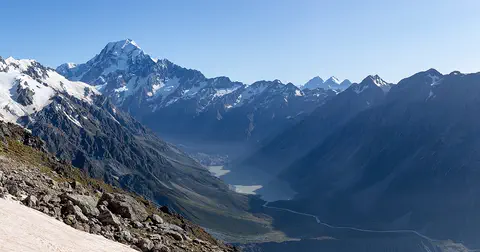
Aoraki / Mount Cook is New Zealand's highest mountain, in the Southern Alps of the South Island. Its name joins its Māori name, Aoraki, with its English name, Mount Cook. The mountain is being pushed up where two of Earth's plates meet, and glaciers carve the valleys around it. In 2013 surveyors measured it at 3,724 meters.
-
 Watch
Landmark
Te Papa
Te Papa, the Museum of New Zealand, opened on Cable Street in Wellington on 14 February 1998. Its name means 'container of treasures'. The building stands on soft land near a major fault line, so it sits on 152 base isolators that let it move gently in an earthquake.
-
 Watch
Natural wonder
Milford Sound / Piopiotahi
Milford Sound / Piopiotahi is a fiord in Fiordland National Park, in the south-west of New Zealand's South Island. Glaciers carved its steep valley, and the sea filled it. It stretches 16 kilometers to the open sea, and Mitre Peak rises 1,692 meters straight from the water. It is one of the wettest places in New Zealand.
-
 Watch
Natural wonder
Mount Ruapehu
Mount Ruapehu, at 2,797 meters, is the highest mountain in New Zealand's North Island and an active volcano. A crater lake fills its vent, and DOC says lahars, fast volcanic mudflows, are its main volcanic hazard.
-
 Watch
Natural wonder
Tongariro National Park
Tongariro National Park, in the middle of New Zealand's North Island, is the country's oldest national park. At its heart are three active volcanoes: Ruapehu, Tongariro and Ngāuruhoe. The mountains are important to the Māori people of the area, and UNESCO lists the park as a World Heritage Site for both its nature and its culture.
-
 Watch
Natural wonder
Lake Taupō
Lake Taupō, in the center of New Zealand's North Island, is the country's largest lake. It fills the caldera of Taupō volcano, which last erupted over 1,800 years ago.
Explore next
-
Watch
 Country
New Zealand
New Zealand, also called Aotearoa, is an island country in the South Pacific. Its two main islands have snowy mountains, glaciers, volcanoes and deep fiords, and about 5.36 million people lived there in 2026.
-
 Watch
City
Hobart
Hobart is the capital of Tasmania, the island state of Australia. It lies on the Derwent estuary, and kunanyi / Mount Wellington dominates its skyline. The City of Hobart calls it Australia's second-oldest city. About 233,736 people lived in the Hobart urban area in mid-2025.
-
 Watch
City
Sydney
Sydney is Australia's largest city and the capital of the state of New South Wales. It surrounds Port Jackson, a harbor of countless bays, on the lands of the Gadigal people of the Eora Nation. The British set up a convict colony here in 1788. Today the Harbour Bridge, the Opera House and its beaches are world famous, and about 5.45 million people lived in Greater Sydney in 2023.
-
 Watch
City
Adelaide
Adelaide is the capital of South Australia. About 1.49 million people lived in Greater Adelaide in mid-2025. Founded in 1837, it was laid out on a plan by Colonel William Light, with a grid of streets ringed by green Park Lands, on the land of the Kaurna people.
-
 Watch
City
Alofi
Alofi is the capital of Niue, a raised coral island in the Pacific Ocean. It is made up of two villages, Alofi North and Alofi South, by Alofi Bay. A census in 2022 counted 606 people in Alofi.
-
 Watch
City
Brisbane
Brisbane is the capital of Queensland, in eastern Australia. An estimated 1,375,301 people lived in the City of Brisbane in mid-2025, and the wider Brisbane area about 2.7 million, the third-largest in Australia. It began in 1825 as a penal colony on a bend of the Brisbane River.
-
 Watch
City
Canberra
Canberra is the capital of Australia. Instead of growing slowly, it was planned: in 1912 Walter Burley Griffin, a city planner from Chicago, won a competition to design it, and the city was named in 1913. Its center is a lake made by damming a river, and Parliament House is built into a hill with grass on its roof.
-
 Watch
City
Funafuti
Funafuti is the atoll that serves as the capital of Tuvalu, a small island country in the Pacific Ocean. Its main island, Fongafale, is long and very narrow. Tuvalu's 2022 census counted 6,602 people on the atoll.
For parents & teachers
What children will learn
- Locate Christchurch on the Canterbury Plains of New Zealand's South Island.
- Explain why a city a few kilometers inland might use a port on the other side of hills.
- Describe a grid street plan and why planners like it.
- Read a Southern Hemisphere climate table where January is summer.
Recommended ages: 3 to 17 · About 15 minutes
Talk about it
- Why do you think the settlers laid out the streets in a grid?
- Why might people dig tunnels instead of building roads over hills?
- How would your year feel if summer came in January?
Try at home or in class
- Grid town: draw a town of straight streets around a central square, then plan where a park would go.
- Season swap: make two calendars, one for your town and one for Christchurch, and color the summer months.
- Park math: Hagley Park is 164.6 hectares. A hectare is 100 m by 100 m. Pace out 100 m outside and imagine 164 squares that size.
Key vocabulary: plain, grid, settler, urban area, Southern Hemisphere, tunnel
Where these facts come from
- Wikidata , Wikimedia Foundation (CC0 1.0)
- Natural Earth vector data , Natural Earth (NACIS) (Public domain)
- Christchurch , Encyclopædia Universalis
- New Zealand: Major Urban Areas and Urban Areas , City Population (Thomas Brinkhoff), from Stats NZ
- Christchurch: climatological information , World Meteorological Organization, World Weather Information Service
- File:Christchurch City.jpg (P. Stalder, September 2006) , Wikimedia Commons
- Wikimedia Commons , Wikimedia Foundation (Per file (public domain, CC0, CC BY or CC BY-SA); see each media record)
Checked, not yet human-reviewed. Last updated November 1, 2026. Spotted a mistake? Tell us.