
Natural wonder Australia and Oceania
Southern Alps / Kā Tiritiri o te Moana
The Southern Alps are tall, snowy mountains in New Zealand. They should keep rising over time.
The Southern Alps / Kā Tiritiri o te Moana stretch hundreds of kilometers along New Zealand's South Island. Two of Earth's plates push together here, along the Alpine Fault, and NASA says the mountains should keep rising over time.
The Southern Alps / Kā Tiritiri o te Moana form the spine of South Island, built by the collision of the Indo-Australian and Pacific plates along the Alpine Fault. UNESCO notes they rise to nearly 4,000 m within 30 km of the sea.
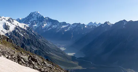
Photo: Michal Klajban, CC BY-SA 4.0, via Wikimedia Commons
Discover the Southern Alps
The Southern Alps are a long line of snowy mountains in New Zealand.
In this photo, jagged white peaks rise above brown, grassy ridges.
NASA describes the Southern Alps as a spine of white mountains stretching hundreds of kilometers across New Zealand's South Island. Their highest peak is Aoraki / Mount Cook. UNESCO calls the range the Southern Alps / Kā Tiritiri o te Moana and says the mountains rise to nearly 4,000 meters within just 30 kilometers of the sea.
This photo by Michal Klajban, taken on 20 June 2020 from Yeats Ridge Hut in the West Coast Region, shows the jagged, snowy peaks of the Main Divide above brown tussock ridges and a deep, green valley.
NASA's Earth Observatory: the snowcapped Southern Alps stretch hundreds of kilometers across South Island (Te Waipounamu), with Aoraki / Mount Cook the highest peak at approximately 3,750 m. UNESCO's Te Wāhipounamu listing: the range, the Southern Alps / Kā Tiritiri o te Moana, rises to nearly 4,000 m within a mere 30 km of the sea.
The photo (Michal Klajban, CC BY-SA 4.0, 20 June 2020, a Commons featured picture) is titled 'Main Divide from Yeats Ridge Hut, West Coast Region'. It shows jagged, snow-streaked peaks above tussock-covered ridges and a deep, forested valley under a clear sky.
- Highest peak (NASA)
- Aoraki / Mount Cook
- Rise (UNESCO)
- nearly 4,000 m within 30 km of the sea
- Plate boundary
- the Alpine Fault
Two plates pushing together
Two huge pieces of the Earth's crust push together here.
The push lifts the mountains up, very slowly.
UNESCO explains that the great Alpine Fault runs through this region. It marks where the Indo-Australian Plate and the Pacific Plate meet, and it is one of only three parts of the world's major plate boundaries that are on land.
The two plates collide here, and that collision builds the Southern Alps. NASA says the central part of the fault runs the length of South Island, and as the plates keep pushing together, the mountains should keep rising.
UNESCO: the great Alpine Fault marks the contact zone of the Indo-Australian and Pacific continental plates, one of only three segments of the world's major plate boundaries on land; collision between the plates constructs the main range.
NASA describes the Alpine Fault as the major surface expression of the plate boundary, its central section running the length of South Island; as the plates progressively converge, the Southern Alps should continue to rise over time.
Glaciers and a rain shadow
The west side of the mountains gets lots of rain and snow. The east side is drier.
Some glaciers flow down into rainforest.
NASA says the mountains make a rain shadow. On the west side, the mountains and foothills get rain and snow all year. On the east side, the land is drier, with many days without clouds.
UNESCO says Ice Age glaciers carved deep U-shaped valleys, lakes and fiords in the southwest. Today the Franz Josef and Fox glaciers still flow down into temperate rainforest.
NASA: the range creates a rain-shadow effect; the west side and its foothills have frequent rain and snowfall year-round, while the downwind east has a more arid climate and many cloud-free days.
UNESCO: Pleistocene glaciers carved fiords, lakes, deep U-shaped valleys, hanging valleys, cirques and ice-shorn spurs; outwash gravels and moraine ridges west of the Alpine Fault outline former piedmont and Holocene valley glaciers; the Franz Josef and Fox Glaciers descend into temperate rainforest.
Rare birds of the southwest
Rare birds live in the wild southwest, like the takahē and a kiwi called the rowi.
Tussock grass grows on the open hills.
UNESCO's Te Wāhipounamu – South West New Zealand, which reaches from Fiordland in the south to the Southern Alps in the north, holds the whole wild population of the rare takahē and of the rowi, New Zealand's rarest kiwi.
It also has large populations of the kākā and the yellow-crowned parakeet. UNESCO says its plants and animals are the world's best intact living example of the ancient life of Gondwana, the old southern supercontinent.
Te Wāhipounamu (UNESCO, 1990; 2.6 million ha, including the Mount Cook and Westland national parks) holds the entire wild population of the endangered takahē (Notornis mantelli) and of the rowi (Apteryx rowi), New Zealand's rarest kiwi, plus the only large remaining populations of kākā and kākāriki / yellow-crowned parakeet.
Its habitats run along altitudinal gradients from sea level to the permanent snowline, with extensive alpine plant endemism and tussock grasslands; UNESCO calls its biota the best intact modern representation of the ancient biota of Gondwana.
Exploring safely
Mountain weather can change quickly. Stay with your grown-up.
Wear warm layers and sunscreen.
PlayOwl's advice: the western side of the Southern Alps gets rain and snow all year, so mountain weather can turn cold and wet. Walk only on marked tracks with a grown-up, carry warm, waterproof layers and check the weather first.
Snow and sun together can burn skin. The CDC says UV rays reflect off snow, so wear sunscreen, sunglasses and a hat.
PlayOwl's advice, based on NASA's account of year-round rain and snowfall on the western side: keep to marked tracks, carry warm and waterproof layers, and check forecasts and track conditions first.
CDC sun safety: UV rays reflect off surfaces such as snow, water and sand; use broad-spectrum sunscreen, UV-blocking sunglasses and a wide-brimmed hat.
Amazing facts
-
These mountains sit on a crack where two plates meet, on land.
The Alpine Fault is one of only three stretches of the world's major plate boundaries that are on land.
UNESCO: the Alpine Fault, contact zone of the Indo-Australian and Pacific plates, is one of only three segments of the world's major plate boundaries on land.
-
Some glaciers here reach all the way down to a rainforest.
The Franz Josef and Fox glaciers flow down into temperate rainforest.
UNESCO lists the Franz Josef and Fox Glaciers, descending into temperate rainforest, among Te Wāhipounamu's spectacular landforms.
-
Astronauts can see the snowy mountains from space.
From the International Space Station, the Southern Alps look like a white spine across South Island.
NASA: astronaut photograph ISS063-E-52878 (13 July 2020) shows the snowcapped Southern Alps as a spine of white across South Island.
Words to know
- tectonic plate
- a huge, slowly moving piece of the Earth's outer shell
- fault
- a crack in the Earth's crust where rocks move past each other
- rain shadow
- a drier area on the side of mountains away from the wet winds
- tussock
- a thick clump of tall grass
- glacier
- a huge, slow-moving river of ice
Discovery challenge
-
In which country are the Southern Alps?
The Southern Alps run along the South Island of which country?
The Southern Alps / Kā Tiritiri o te Moana form the spine of which country's South Island?
- New Zealand
- Switzerland
- Canada
Show the answer
New Zealand
New Zealand.
New Zealand.
New Zealand (NASA; UNESCO).
-
What pushes the mountains up?
What builds the Southern Alps?
According to UNESCO, what constructs the main range?
- Two plates pushing together
- Ocean waves
- Desert winds
Show the answer
Two plates pushing together
Two plates pushing together.
The collision of two of Earth's plates.
Collision between the Indo-Australian and Pacific plates (UNESCO).
-
What is the name of the big crack along the mountains?
Which fault marks where the two plates meet?
Which fault is the major surface expression of the plate boundary on South Island?
- The Alpine Fault
- The San Andreas Fault
- The Great Glen Fault
Show the answer
The Alpine Fault
The Alpine Fault.
The Alpine Fault.
The Alpine Fault (NASA; UNESCO).
-
Which side of the mountains is drier?
Which side of the Southern Alps lies in the rain shadow?
On which side does NASA describe a more arid climate with many cloud-free days?
- The east side
- The west side
- Both sides are the same
Show the answer
The east side
The east side.
The east side.
The downwind east side (NASA).
-
Which mountain is the highest?
What is the highest peak in the Southern Alps?
Which peak does NASA name as the highest in the range?
- Aoraki / Mount Cook
- Mount Everest
- Mont Blanc
Show the answer
Aoraki / Mount Cook
Aoraki / Mount Cook.
Aoraki / Mount Cook.
Aoraki / Mount Cook (NASA).
Nearby places
-
 Watch
Natural wonder
South Island
The South Island of New Zealand sits where two of Earth's tectonic plates meet. Their collision built the Southern Alps, which rise to nearly 4,000 meters close to the sea. Glaciers carved its fiords and lakes, and its southwest is a World Heritage area full of rare birds.
-
 Watch
Natural wonder
Aoraki / Mount Cook
Aoraki / Mount Cook is New Zealand's highest mountain, in the Southern Alps of the South Island. Its name joins its Māori name, Aoraki, with its English name, Mount Cook. The mountain is being pushed up where two of Earth's plates meet, and glaciers carve the valleys around it. In 2013 surveyors measured it at 3,724 meters.
-
 Watch
City
Christchurch
Christchurch is the main city of New Zealand's South Island. Universalis says English settlers founded it in 1850 on the wide Canterbury Plains, a few kilometers from the east coast. Its port, Lyttelton, lies beyond the Port Hills. About 407,800 people lived in the Christchurch urban area in mid-2025.
-
 Watch
Natural wonder
Milford Sound / Piopiotahi
Milford Sound / Piopiotahi is a fiord in Fiordland National Park, in the south-west of New Zealand's South Island. Glaciers carved its steep valley, and the sea filled it. It stretches 16 kilometers to the open sea, and Mitre Peak rises 1,692 meters straight from the water. It is one of the wettest places in New Zealand.
-
 Watch
Landmark
Te Papa
Te Papa, the Museum of New Zealand, opened on Cable Street in Wellington on 14 February 1998. Its name means 'container of treasures'. The building stands on soft land near a major fault line, so it sits on 152 base isolators that let it move gently in an earthquake.
-
 Watch
Natural wonder
Mount Ruapehu
Mount Ruapehu, at 2,797 meters, is the highest mountain in New Zealand's North Island and an active volcano. A crater lake fills its vent, and DOC says lahars, fast volcanic mudflows, are its main volcanic hazard.
-
 Watch
Natural wonder
Tongariro National Park
Tongariro National Park, in the middle of New Zealand's North Island, is the country's oldest national park. At its heart are three active volcanoes: Ruapehu, Tongariro and Ngāuruhoe. The mountains are important to the Māori people of the area, and UNESCO lists the park as a World Heritage Site for both its nature and its culture.
-
 Watch
Natural wonder
Lake Taupō
Lake Taupō, in the center of New Zealand's North Island, is the country's largest lake. It fills the caldera of Taupō volcano, which last erupted over 1,800 years ago.
Explore next
-
Watch
Natural wonder
Aoraki / Mount Cook
Aoraki / Mount Cook is New Zealand's highest mountain, in the Southern Alps of the South Island. Its name joins its Māori name, Aoraki, with its English name, Mount Cook. The mountain is being pushed up where two of Earth's plates meet, and glaciers carve the valleys around it. In 2013 surveyors measured it at 3,724 meters.
-
Watch
Natural wonder
South Island
The South Island of New Zealand sits where two of Earth's tectonic plates meet. Their collision built the Southern Alps, which rise to nearly 4,000 meters close to the sea. Glaciers carved its fiords and lakes, and its southwest is a World Heritage area full of rare birds.
-
Watch
 Country
New Zealand
New Zealand, also called Aotearoa, is an island country in the South Pacific. Its two main islands have snowy mountains, glaciers, volcanoes and deep fiords, and about 5.36 million people lived there in 2026.
- Watch Geography Tectonic plates Earth's hard outer shell is cracked into a dozen or so giant pieces called tectonic plates. They carry the continents and oceans and move a few centimeters a year. Where plates pull apart, push together or slide past each other, we find volcanoes, mountains and earthquakes.
-
 Watch
Animal
Takahē
The takahē is a large bird from New Zealand that cannot fly. It is the biggest living rail in the world, with blue and green feathers, a huge red beak and strong red legs. People thought it had died out, until it was found again in the mountains of Fiordland in 1948. In 2023 there were about 500 takahē, in wild grasslands and in safe sanctuaries, and the number is growing.
-
 Watch
Natural wonder
Great Barrier Reef
The Great Barrier Reef stretches about 2,300 kilometers along the coast of Queensland, Australia. It is made of about 2,500 separate reefs and more than 900 islands, built by tiny coral animals, and it is home to more than 1,500 kinds of fish.
-
 Watch
Natural wonder
Uluru
Uluru is a huge sandstone rock in the desert of central Australia, rising 348 meters above the plain, with a base 9.4 kilometers around. The Anangu are its Traditional Owners, and the national park around it is run by Anangu and Parks Australia together.
-
 Watch
Natural wonder
Kakadu National Park
Kakadu, in Australia's Northern Territory, is the country's largest national park. It stretches from a high sandstone cliff called the escarpment down to floodplains, mangroves and the sea. Aboriginal people have lived here for tens of thousands of years, and their rock paintings, some up to 20,000 years old, record their way of life.
For parents & teachers
What children will learn
- Locate the Southern Alps along New Zealand's South Island.
- Explain how colliding plates can build a mountain range.
- Describe how mountains make a rain shadow.
- Name rare birds protected in the southwest of South Island.
Recommended ages: 3 to 17 · About 15 minutes
Talk about it
- Why might mountains on a plate boundary keep rising?
- How might the wet west and dry east of the range differ for plants and animals?
- Why might birds without mammal predators be at risk when new animals arrive?
Try at home or in class
- Push two towels together on a table and watch the folds rise between them, like mountains at a plate boundary.
- Spray water at one side of a pile of books and see which side stays dry, like a rain shadow.
Key vocabulary: tectonic plate, fault, rain shadow, tussock, glacier
Where these facts come from
- Wikidata , Wikimedia Foundation (CC0 1.0)
- The Spine of South Island , NASA Earth Observatory
- Te Wahipounamu – South West New Zealand (World Heritage List) , UNESCO World Heritage Centre
- Sun Safety Facts , US Centers for Disease Control and Prevention
- File:Main Divide from Yeats Ridge Hut, West Coast Region, New Zealand.jpg , Wikimedia Commons
- Natural Earth vector data , Natural Earth (NACIS) (Public domain)
- Wikimedia Commons , Wikimedia Foundation (Per file (public domain, CC0, CC BY or CC BY-SA); see each media record)
Checked, not yet human-reviewed. Last updated November 1, 2026. Spotted a mistake? Tell us.