
City Asia
Mumbai
Mumbai is a huge city by the sea in India. It was built on small islands that were joined together. Lots of trains carry people around it.
Mumbai, once called Bombay, is a giant port city on India's west coast, by the Arabian Sea. It grew on seven small islands that were joined into one, and it is India's main center of business and banking. At the 2011 census, more than 12 million people lived in the city and more than 18 million in its urban area.
Mumbai, capital of Maharashtra, occupies Bombay Island, formed since the 17th century by joining seven islets, and the larger Salsette Island to the north. India's financial hub and principal port on the Arabian Sea, it counted 12,442,373 people in Greater Mumbai and 18,394,912 in its urban agglomeration at the 2011 Census of India, the most recent completed census.
Photo: Dr Vikramjit Kakati, CC BY-SA 4.0, via Wikimedia Commons
Discover Mumbai
Mumbai is a very big city in India.
It sits right next to the sea. Long ago, it was seven little islands. People joined the islands together to make one big piece of land.
Mumbai is a port city on the west coast of India, beside the Arabian Sea. It is the capital of the state of Maharashtra and India's biggest center for business and banking. Its old name, Bombay, came into use when Britain ruled the city; the name Mumbai was officially brought back in 1995.
At the 2011 Census of India, more than 12 million people lived in Greater Mumbai, and more than 18 million in the whole urban area around it. Mumbai is India's most-populous city and one of the most crowded places on Earth.
Mumbai, capital of Maharashtra state, is India's financial and commercial center and its principal port on the Arabian Sea. Britannica calls it the country's most-populous city and one of the largest and most densely populated urban areas in the world. The city was known as Bombay during British rule; the name Mumbai was officially restored in 1995, though Bombay stayed in common use.
Population figures depend on the boundary used. The 2011 Census of India, the most recent completed census, counted 12,442,373 people in Greater Mumbai, an area of about 619 km², and 18,394,912 in the wider urban agglomeration (final census tables; Britannica quotes the slightly higher provisional totals). By the early 21st century, Greater Mumbai averaged some 29,500 people per km², densest in the old southern districts.
- Country
- India (capital of Maharashtra state)
- People in Greater Mumbai (2011 census)
- more than 12 million
- People in the urban area (2011 census)
- more than 18 million
- Area of Greater Mumbai
- about 619 km²
Famous places
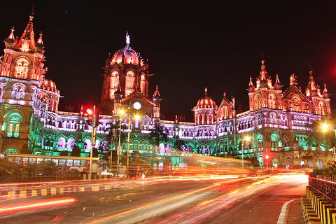
Mumbai has a train station that looks like a palace!
It has domes, towers and pointed arches. By the sea stands a giant stone arch called the Gateway of India. Out in the harbor is an island with old caves carved into the rock.
One of Mumbai's great railway stations, the Chhatrapati Shivaji Terminus, looks like a palace. It was built over 10 years starting in 1878, with a stone dome, turrets and pointed arches. British architects worked with Indian craftsmen to mix the two styles, and UNESCO listed it as a World Heritage Site in 2004.
By the harbor stands the Gateway of India, a huge arch dedicated in 1924. Out in the harbor, on Elephanta Island, cave temples were carved into the rock more than 1,000 years ago. Around a big open green called the Oval Maidan stand rows of grand old buildings, some in Gothic style and some in the sleek Art Deco style.
Chhatrapati Shivaji Terminus (formerly Victoria Terminus), designed by F. W. Stevens and built over ten years from 1878, is a great railway terminus managed by India's Central Railway. UNESCO, which inscribed it in 2004, calls it an outstanding example of Victorian Gothic Revival architecture blended with Indian traditional themes; its stone dome, turrets and pointed arches recall Indian palace design.
The Gateway of India, dedicated in 1924 to commemorate the visit of King George V and Queen Mary, is a large arch overlooking Mumbai Harbor. The cave temples of Elephanta Island, from the 8th and 9th centuries according to Britannica, became a World Heritage Site in 1987. In 2018 UNESCO added the Victorian Gothic and Art Deco Ensembles: public buildings bordering the Oval Maidan, first Neo-Gothic, then, in the early 20th century, Art Deco cinemas and apartment blocks that blend Indian design with Art Deco imagery, a style described as "Indo-Deco".
- Chhatrapati Shivaji Terminus
- built over 10 years from 1878; UNESCO site 2004
- Gateway of India
- dedicated 1924
- Elephanta Caves
- UNESCO site 1987
- Victorian Gothic and Art Deco buildings
- UNESCO site 2018
From seven islands to one city
Long ago, fishing families lived on Mumbai's islands.
Ships came to trade. Later, people filled in the water between the islands. Factories made cotton cloth, and the town grew into a giant city.
The first known people of Mumbai were the Koli, a community of fishers. Over many centuries, different kingdoms ruled the islands. In 1534 the Portuguese took control, and in 1661 the islands passed to Britain, which handed them to the East India Company in 1668.
Since the 1600s, people have drained marshes and built causeways and seawalls to join the seven islands into one. In 1857 the first cotton mill opened, and by 1860 Bombay was India's largest cotton market. After India's independence in 1947, the city became the capital of the new state of Maharashtra in 1960.
The Koli, a community of fishers, are the earliest known inhabitants, though Paleolithic stone tools found at Kandivli show people in the area hundreds of thousands of years ago. Ruled in turn by regional dynasties, the island became part of the kingdom of Gujarat in 1348, was ceded to the Portuguese in 1534, passed to the English crown in 1661 in the marriage settlement of Charles II and Catherine of Braganza, and went to the East India Company in 1668.
The city grew as merchants and artisans arrived around 1800. The first spinning and weaving mill opened in 1857; by 1860 Bombay was India's largest cotton market, and the American Civil War brought a cotton boom. The Suez Canal (1869) sped trade with Europe. The Indian National Congress held its first session here in 1885 and passed its "Quit India" resolution here in 1942. After the split of Bombay state in 1960, the city became capital of Maharashtra.
Getting around Mumbai
Mumbai's local trains are always busy.
They carry huge crowds to work every day. Black-and-yellow taxis and little three-wheeled auto-rickshaws zip along the roads. A long bridge even crosses the sea!
Suburban electric trains are the main way people travel in Mumbai, carrying hundreds of thousands of commuters every day. Thousands of taxis and auto-rickshaws, painted black and yellow, fill the streets, and city buses run too. A metro line opened in 2014, and so did the first part of a monorail.
Because Mumbai is built on islands, bridges matter. The Bandra–Worli Sea Link, opened in 2009, crosses Mahim Bay. Long-distance trains leave for every part of India, and Mumbai's airport is one of the country's two biggest air hubs.
Britannica describes suburban electric trains as the main public transport, carrying hundreds of thousands of commuters across the metropolitan region daily. Thousands of taxis and auto-rickshaws, fueled by liquid petroleum gas and painted black and yellow, supplement a municipal bus fleet; the first rapid-transit (metro) line and the first portion of a monorail both opened in 2014.
The city is the railhead of the Western and Central railways. Island geography makes bridges essential: Salsette Island was linked to the mainland across Thana Creek in the early 1970s, the Bandra–Worli Sea Link spans Mahim Bay (2009), and an expressway to Navi Mumbai opened in 2014. Chhatrapati Shivaji International Airport, in the north of the city, is one of India's two principal air hubs with Delhi. Mumbai remains India's principal western port, supplemented since 1989 by a container facility in Navi Mumbai.
- Main public transport
- suburban electric trains
- First metro line
- 2014
- Bandra–Worli Sea Link
- opened 2009
- Airport
- Chhatrapati Shivaji International
Hot sun and monsoon rain
Mumbai is warm all year.
In summer, the monsoon comes. Huge rainstorms fall for months! Then the rain stops, and the dry, sunny months come back.
Mumbai is warm and humid all year. At the World Meteorological Organization's Colaba station, at the city's southern tip, January days averaged about 31 °C and nights about 17 °C between 1951 and 2000.
The big event is the monsoon. From June to September, winds from the southwest bring heavy rain. July alone averaged about 819 millimeters of rain at Colaba. From December to April, very little rain falls at all.
Britannica describes four seasons: cool from December to February, hot from March to May, the southwest monsoon from June to September, and a hot post-monsoon season in October and November. WMO normals for the Mumbai (Colaba) station, 1951–2000, give average daily highs and lows of about 31 °C and 17 °C in January and about 30 °C and 25 °C in July, so July days are slightly cooler than May's (about 33 °C).
The rain is extremely seasonal. The monthly averages add up to about 2,430 mm a year, of which about 2,195 mm falls from June to September, with about 819 mm in July alone, while February to April together average under 2 mm.
- January, average daily high and low (WMO Mumbai/Colaba station, 1951–2000)
- about 31 °C and 17 °C
- July, average daily high and low (same station and period)
- about 30 °C and 25 °C
- Rain in July (same station and period)
- about 819 mm
- Rain in a year (sum of the monthly averages)
- about 2,430 mm
Living in Mumbai
People from all over India live in Mumbai.
They speak many languages. Families go to the beach, watch cricket and visit the zoo. Mumbai also makes lots of movies!
People from almost every part of India, and many other countries, live in Mumbai. Marathi, the language of Maharashtra state, is spoken most, followed by Gujarati, Hindi and Bengali, and many other languages are heard too.
Mumbai is the home of Bollywood, India's huge film industry; the name joins Bombay and Hollywood. Cricket is very popular, and big matches are played at Wankhede Stadium. Juhu and Chowpatty beaches are popular for swimming, and there are parks such as the Hanging Gardens on Malabar Hill. Space is tight, though, and many people live in very crowded homes.
Britannica calls Mumbai truly cosmopolitan: people of almost every region and religion live here, and almost every Indian language is spoken. Marathi, the state language, is the dominant one, followed by Gujarati, Hindi and Bengali. The city is home to the Reserve Bank of India and the Bombay Stock Exchange, India's leading stock market, as well as cotton mills, factories and a growing technology sector.
It is also the center of the Indian film industry, Bollywood. The University of Mumbai, established in 1857, has more than 100 constituent colleges. Housing is scarce and crowded on the island site, and many people live in informal settlements; air and water pollution are long-standing problems. For leisure there are cricket at Wankhede and Brabourne stadiums, the Juhu and Chowpatty beaches, the zoo at Jijamata Udyan and the forests of a national park in the north of the metropolitan area, near the Kanheri Caves.
- Main language of the state
- Marathi
- Film industry
- Bollywood
- University of Mumbai
- established 1857
Mumbai on the map
Find Mumbai on the globe.
It is in India, in Asia. Look on the west side of India, by the Arabian Sea. Mumbai pokes out into the sea like a thumb.
Mumbai is on the west coast of India, on the Konkan coast of the Arabian Sea. The old city sits on Bombay Island, a long, thin piece of land pointing south. To its east are the calm waters of Mumbai Harbor, and to its west is the open sea.
North of the old city lies the much bigger Salsette Island, joined on in 1950. Across the harbor rise the Western Ghats, a long range of mountains on the mainland.
Mumbai lies at about 19.0° N and 72.9° E on the Konkan coast. Bombay Island is a low plain, about a quarter of it below sea level, flanked by two parallel ridges of low hills. The longer ridge ends in Colaba Point, which shields Mumbai Harbor from the open sea; the western ridge ends at Malabar Hill, about 55 m high. Between them curves the shallow Back Bay.
The old city ran from Colaba to Mahim and Sion on the island's north coast. In 1950 the city expanded onto Salsette Island, joined by a causeway, and by 1957 suburban boroughs there were part of Greater Mumbai. To the east, across the harbor, the Western Ghats frame the view from the sea, and Navi Mumbai lies across the harbor on the mainland.
- Latitude
- about 19.0° north
- Longitude
- about 72.9° east
- Highest point on Bombay Island's western ridge
- Malabar Hill, about 55 m
Amazing facts
-
Mumbai was once seven small islands.
Since the 1600s, people have drained marshes and built causeways and seawalls to join Mumbai's seven islands into one.
Bombay Island was formed from seven islets joined since the 17th century by drainage and reclamation, causeways and breakwaters; about a quarter of it lies below sea level.
-
Bollywood movies are made in Mumbai.
The name Bollywood, for India's huge film industry in Mumbai, joins Bombay, the city's old name, with Hollywood.
Bollywood, the name of the Indian film industry centered in Mumbai, blends Bombay and Hollywood.
-
Mumbai's taxis are painted black and yellow.
Mumbai's thousands of taxis and auto-rickshaws are easy to spot: they are painted black and yellow.
Mumbai's taxis and auto-rickshaws run on liquid petroleum gas and are known for their black-and-yellow bodies.
-
British architects and Indian craftsmen built Mumbai's big train station together.
At Chhatrapati Shivaji Terminus, British architects worked with Indian craftsmen to create a new style found only in Mumbai.
UNESCO calls the terminus an outstanding example of the meeting of two cultures, as British architects worked with Indian craftsmen to forge a style unique to Bombay.
-
In July, Mumbai can get more rain than some cities get all year.
July at Mumbai's Colaba weather station averaged about 819 millimeters of rain between 1951 and 2000.
WMO normals for Colaba (1951–2000) put July rainfall at about 819 mm, roughly a third of the year's total of about 2,430 mm.
Words to know
- port
- a town or city with a harbor where ships load and unload
- monsoon
- a seasonal wind that brings a long, very rainy season
- causeway
- a raised road built across water or wet ground
- reclaim
- to make new dry land by filling in or draining water
- auto-rickshaw
- a small three-wheeled taxi
- census
- an official count of all the people in a country
- urban agglomeration
- a city together with the built-up towns that have grown around it
Discovery challenge
-
Which sea is next to Mumbai?
Mumbai is a port on which sea?
Mumbai is India's principal port on which sea?
- The Baltic Sea
- The Arabian Sea
- The Caribbean Sea
Show the answer
The Arabian Sea
The Arabian Sea! It is on India's west side.
Mumbai is on India's west coast, beside the Arabian Sea.
Mumbai, on the Konkan coast, is India's principal port on the Arabian Sea and its main western port.
-
How many little islands joined to make old Mumbai?
How many islets were joined together to make Bombay Island?
Bombay Island was formed by joining how many islets since the 17th century?
- Two
- Seven
- Twenty
Show the answer
Seven
Seven! People joined them to make one island.
Seven islets were joined by draining, filling and building causeways and seawalls.
Seven islets, joined through drainage, reclamation, causeways and breakwaters.
-
What is the Chhatrapati Shivaji Terminus?
What is Mumbai's Chhatrapati Shivaji Terminus, begun in 1878?
What is the Chhatrapati Shivaji Terminus, inscribed by UNESCO in 2004?
- A train station
- A sports stadium
- A beach
Show the answer
A train station
A train station! It looks like a palace.
It is one of Mumbai's great railway stations, built over 10 years in a mix of Gothic and Indian styles.
It is a railway terminus managed by India's Central Railway, a Victorian Gothic Revival building with Indian palace forms.
-
When does the most rain fall in Mumbai?
In which month does Mumbai get the most rain, on average?
In which month does the WMO Colaba station record about 819 mm of rain, on average?
- January
- July
- December
Show the answer
July
July! That is the monsoon.
July averages about 819 millimeters of rain at Colaba, in the middle of the monsoon.
July, at the height of the southwest monsoon (June to September), averages about 819 mm at Colaba.
-
What is Mumbai's film industry called?
What is the name of the huge film industry based in Mumbai?
Which name, blending the city's former name with Hollywood, describes Mumbai's film industry?
- Bollywood
- Silicon Valley
- Broadway
Show the answer
Bollywood
Bollywood! Lots of movies are made there.
Bollywood. The name mixes Bombay, the city's old name, with Hollywood.
Bollywood, from Bombay plus Hollywood, is the center of India's enormous film industry.
Nearby places
-
 Watch
Natural wonder
Ajanta Caves
The Ajanta Caves are about 30 halls and rooms carved by hand into a curving cliff above the Waghora River in western India. Buddhist communities made them in two big phases, starting more than 2,000 years ago. Their wall paintings and stone carvings are some of the most famous ancient art in India, and they have been a UNESCO World Heritage Site since 1983.
-
 Watch
Landmark
Fatehpur Sikri
Fatehpur Sikri, the "City of Victory," was built on a ridge near Agra, India, by the Mughal emperor Akbar from 1571. It was his capital until 1585. Its red sandstone palaces, halls and great mosque still stand, and its gateway, the Buland Darwaza, is 40 meters tall.
-
 Watch
Landmark
Mohenjo-daro
Mohenjo-daro was the largest city of the Indus civilization, which UNESCO calls one of the world's three great ancient civilizations. Built of baked brick and flourishing by about 2500 BCE beside the Indus River, it had streets in a neat grid, houses with bathrooms and covered drains. Its ruins were found in 1922.
-
 Watch
Landmark
Agra Fort
Agra Fort is a huge red sandstone fortress beside the Yamuna River in Agra, India. The Mughal emperor Akbar began it in 1565. Its walls, about 2.5 kilometers around, protect palaces, halls and mosques added by later emperors. It was both an army base and a royal home.
-
 Watch
Landmark
Taj Mahal
The Taj Mahal is a white marble tomb in Agra, India, beside the Yamuna River. The Mughal emperor Shah Jahan had it built in memory of his wife, Mumtaz Mahal. More than 20,000 workers spent about 22 years on the tomb, its gardens, a mosque and a great gateway.
-
 Watch
Natural wonder
Ganges
The Ganges, called the Ganga in India, flows about 2,510 kilometers from a glacier in the Himalayas across the plains of northern India to the Bay of Bengal, through India and Bangladesh. Its basin is home to hundreds of millions of people who farm, fish and travel on it. For many Hindus it is the holiest of rivers. Near the sea it builds a giant delta with the Brahmaputra.
-
 Watch
Landmark
Harmandir Sahib (Golden Temple)
Harmandir Sahib, often called the Golden Temple, is the most important gurdwara, or place of worship, for Sikhs. It stands on a small island in a pool in Amritsar, India, and a marble causeway leads out to it. Its upper stories are covered in gilded copper, and its free kitchen serves meals to about 100,000 people a day.
-
 Watch
Landmark
Anuradhapura
Anuradhapura, in north-central Sri Lanka, was the island's capital for more than 1,000 years. Its ruins include huge bell-shaped brick monuments called dagobas, monasteries, palaces and ancient reservoirs. It is an important place for Buddhists, and a World Heritage Site since 1982.
Explore next
-
Watch
 Country
India
India is a huge country in South Asia, shaped like a big triangle pointing into the Indian Ocean. The Himalayas rise along its north, heavy monsoon rains arrive every summer, and about 1.46 billion people (2025) live there, speaking hundreds of languages.
-
Watch
Life around the world
Lunchbox delivery in Mumbai
Every working day, Mumbai's dabbawalas collect home-cooked lunches in metal tiffin boxes, carry them by bicycle, on foot and on the city's local trains, and deliver them to offices by lunchtime. Colored letters, numbers and symbols painted on each box tell them where it goes, and the empty boxes travel home in the afternoon.
- Watch Geography Monsoons A monsoon is a seasonal change in the direction of a region's strongest winds. In South Asia, the summer monsoon blows warm, wet air in from the Indian Ocean and brings months of heavy rain, while the winter monsoon blows dry air from the land. About three-quarters of India's yearly rain falls in the monsoon season, so farms, wells, rivers and power stations all depend on it.
- Watch Geography Islands An island is a piece of land surrounded by water that is smaller than a continent. Islands form in different ways: some broke away from continents, some were built by volcanoes on the sea floor, and some were made by corals or by waves piling up sand. Because they are cut off by water, islands often have unusual plants and animals.
- Watch Geography Population density Population density tells you how crowded a place is. You find it by dividing the number of people by the area of land they live on, usually as people per square kilometer. Among countries, World Bank figures for 2024 range from more than 18,000 people per square kilometer in Monaco to about 2 in Mongolia. People cluster where there is water, farmland and work, and leave harsh places almost empty.
-
 Watch
City
Ankara
Ankara is the capital of Türkiye, in the interior of Anatolia, about 200 kilometers from the Black Sea. People have lived here since the Stone Age, and Romans, Byzantines, Seljuks and Ottomans all left buildings behind. It became the capital in 1923, and today it is a city of government, universities and museums.
-
 Watch
City
Baghdad
Baghdad, the capital of Iraq, stands on the Tigris River in the land once called Mesopotamia. It was founded in 762 as a round city, and for about 500 years it was one of the greatest cities in the world and a great center of learning, where scholars studied math, medicine and the stars. Today it is Iraq's largest city.
-
 Watch
City
Baku
Baku, the capital of Azerbaijan, curves around a bay on the Caspian Sea, the world's largest inland body of water. Its old walled town, with the Maiden Tower and a palace of the Shirvan shahs, is a World Heritage Site, and oil has made the city important for more than 150 years.
For parents & teachers
What children will learn
- Locate Mumbai on India's west coast and explain how seven islets were joined to make the city's land.
- Explain why population numbers differ for a city and its wider urban area.
- Describe how a monsoon climate shapes rainfall through the year.
- Name some of Mumbai's landmarks and the ways people travel around a crowded island city.
Recommended ages: 3 to 17 · About 15 minutes
Talk about it
- Mumbai's people filled in the sea to make more land. What could be good and difficult about building on reclaimed land?
- The city has more than 12 million people, but its wider urban area has more than 18 million. Why might a city's count change depending on where you draw the line?
- Most of Mumbai's rain falls in four months. How would that change your plans for school, play and travel?
Try at home or in class
- Put seven small piles of sand in a tray of shallow water, then join them with more sand into one long island. Talk about how Mumbai's land was made.
- Make a bar chart of Mumbai's rain for January, June, July and August using strips of paper, 1 cm for every 50 mm.
Key vocabulary: port, monsoon, causeway, reclaim, auto-rickshaw, census, urban agglomeration
Where these facts come from
- Wikidata , Wikimedia Foundation (CC0 1.0)
- Natural Earth vector data , Natural Earth (NACIS) (Public domain)
- UNESCO World Heritage List , UNESCO World Heritage Centre (Linked as a reference; site facts come from Wikidata)
- Mumbai , Encyclopaedia Britannica
- Mumbai: City layout, people and economy , Encyclopaedia Britannica
- Mumbai: Transportation, administration and society , Encyclopaedia Britannica
- Mumbai: Cultural life , Encyclopaedia Britannica
- Mumbai: History , Encyclopaedia Britannica
- Maharashtra: cities and towns (Census of India 2011 final figures) , City Population (Thomas Brinkhoff)
- India: major agglomerations (Census of India 2011) , City Population (Thomas Brinkhoff)
- Chhatrapati Shivaji Terminus (formerly Victoria Terminus) , UNESCO World Heritage Centre
- Victorian Gothic and Art Deco Ensembles of Mumbai , UNESCO World Heritage Centre
- Mumbai: climatological information , World Meteorological Organization, World Weather Information Service
- Wikimedia Commons , Wikimedia Foundation (Per file (public domain, CC0, CC BY or CC BY-SA); see each media record)
Checked, not yet human-reviewed. Last updated October 27, 2026. Spotted a mistake? Tell us.