Skip to content
Search the Discovery Encyclopedia
-
Geography
The five oceans
There is really only one global ocean, covering about 71 percent of Earth and holding about 97 percent of its water. People divide it into five named oceans: the Pacific, Atlantic, Indian, Southern and Arctic. They are all connected, so water and ocean animals can travel from one to the next.
-
Geography
Ocean currents
Ocean currents are flows of seawater from one place to another. Winds push the surface water, and because Earth spins, the currents curve into giant loops called gyres. Deep down, cold, salty water sinks and creeps slowly around the planet. Together, currents carry heat from the warm tropics toward the cold poles.
-
Geography
The ocean floor
The bottom of the ocean is not flat. Starting from the shore, there is a shallow continental shelf, a steep slope, wide abyssal plains, a huge chain of underwater mountains called the mid-ocean ridge, and deep trenches. The deepest place, Challenger Deep in the Mariana Trench, is about 10,935 meters down.
-
Geography
Ocean zones from sunlight to midnight
Scientists divide the ocean into layers called zones. Sunlight reaches only the top 200 meters. Below that is the dim twilight zone, then the pitch-dark midnight zone, the abyss and, deepest of all, the trenches of the hadal zone. The deeper you go, the darker, colder and more squeezed by water it gets.
-
 Natural wonder
Dead Sea
The Dead Sea is a salt lake in the Middle East, with Jordan on its eastern shore and the Palestinian West Bank along part of its western shore. Its surface lies far below sea level, about 435 meters down in 2019, and its water is nearly ten times saltier than the ocean, so swimmers bob on top without trying.
-
Geography
Sea level
The sea's surface moves up and down with waves and tides, so sea level means its average height. It is the zero we use to measure land: Mount Everest is about 8,849 meters above sea level. Satellites show that the global average sea level has risen about 10 centimeters since 1993, mostly because ice on land is melting and warming seawater takes up more room.
-
 Journey
The spice routes by sea
For centuries, ships crossed the Indian Ocean between East Africa, Arabia, India, Sri Lanka and the islands of Southeast Asia, carrying spices such as pepper, cinnamon, cloves and nutmeg. Sailors used the monsoon winds, which blow one way for half the year and the other way for the rest, to make their voyages.
-
Geography
Why we have seasons
Earth's axis is tilted, so as Earth travels around the Sun each year, first one half and then the other leans toward the Sun. The half leaning toward the Sun gets stronger, more direct sunlight and longer days: that is summer. It is not because Earth is closer to the Sun.
-
 Life around the world
Maple syrup season in Quebec, Canada
Each spring in Quebec, nights below freezing and days above it make sap flow in maple trees. Producers collect the watery, slightly sweet sap and boil it in evaporators until it becomes syrup; early in the season about 20 liters of sap make 1 liter. In 2025, Quebec made 90 percent of Canada's maple syrup.
-
Geography
Tides
Tides are the slow rise and fall of the sea along coasts. The Moon's gravity, helped a little by the Sun, pulls Earth's oceans into two bulges. As Earth turns through them, most coasts get two high tides and two low tides every 24 hours and 50 minutes.
-
 Natural wonder
Galápagos Islands
The Galápagos Islands are a group of volcanic islands in the Pacific Ocean, about 1,000 kilometers off the coast of Ecuador. Many of their animals live nowhere else on Earth, and they helped inspire Charles Darwin's theory of evolution by natural selection.
-
 Natural wonder
Great Barrier Reef
The Great Barrier Reef stretches about 2,300 kilometers along the coast of Queensland, Australia. It is made of about 2,500 separate reefs and more than 900 islands, built by tiny coral animals, and it is home to more than 1,500 kinds of fish.
-
 Journey
Building the Panama Canal
Before the Panama Canal, ships going between the Atlantic and Pacific had to sail around the tip of South America. A French company tried to dig a canal across Panama in the 1880s but failed. The United States took over in 1904, defeated dangerous diseases spread by mosquitoes, cut through mountains and built huge locks. The 80-kilometer canal opened in 1914.
-
 Country
Cabo Verde
Cabo Verde is a country made of ten islands in the Atlantic Ocean, about 620 kilometers off the coast of West Africa. Some islands are flat and sandy, others are steep and volcanic, and rain is rare. Its people are famous for their music, and the 2021 census counted about 491,000 people living there.
-
 Country
Mozambique
Mozambique stretches along the Indian Ocean coast of southeastern Africa. The great Zambezi River cuts through its middle, its beaches face the island of Madagascar, and parks like Gorongosa are home to elephants and lions. About 35.6 million people lived there in 2025, and Portuguese is the official language.
-
Natural wonder
Mariana Trench
The Mariana Trench is a long, curving valley in the floor of the western Pacific Ocean, near the island of Guam. Its deepest spot, the Challenger Deep, is the deepest place known in the whole ocean, close to 11,000 meters down. If Mount Everest stood on the bottom, its peak would still be about 2 kilometers under water.
-
 Country
Oman
Oman is a country on the southeastern corner of the Arabian Peninsula, with long coasts on the sea and the huge Empty Quarter desert inland. People have watered their farms with ancient channels called aflaj for more than 2,000 years, and Oman was famous for frankincense. About 5.4 million people lived there in 2026.
-
 Natural wonder
Namib
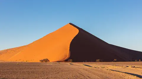
The Namib is a cool desert that runs for about 1,900 kilometers along Africa's Atlantic coast, from Angola through Namibia into South Africa. It gets almost no rain, but cold ocean water makes thick fog that drifts inland. UNESCO says its Namib Sand Sea is the only coastal desert in the world with huge dune fields influenced by fog.
-
 Country
Jordan
Jordan is a kingdom in Southwest Asia, mostly covered by rocky desert. It is home to Petra, a city carved into red sandstone cliffs long ago, the wild valleys of Wadi Rum, and the shore of the Dead Sea, the lowest place on land. About 11.5 million people lived there in 2025.
-
 Country
Eritrea
Eritrea is a country in the Horn of Africa with a long coast on the Red Sea. Its capital, Asmara, sits high in cool mountains, while the coast below has one of the highest average temperatures in the world. About 3.6 million people live there, and its name comes from the Latin words for the Red Sea.
-
 Country
Estonia
Estonia is the northernmost of the three Baltic states in northeastern Europe. Its low land of forests, bogs and lakes was shaped by ice, it has about 1,500 islands and islets, and about 1.36 million people lived there at the start of 2026.
-
 Country
Georgia
Georgia is a country at the eastern end of the Black Sea, below the high, icy Greater Caucasus mountains. It has warm, wet coasts, dry eastern plains and old monasteries, and about 3.9 million people lived there at the start of 2026.
-
 Country
Romania
Romania is a country in southeastern Europe. The Carpathian Mountains curve around its middle, the Danube River runs along its southern edge to a huge delta on the Black Sea, and about 19 million people lived there at the start of 2026.
-
 City
Helsinki
Helsinki is the capital of Finland, on a peninsula in the Gulf of Finland. Founded in 1550 and made the capital in 1812, it has white stone buildings, a sea fortress on islands, and the world's most northern metro. About 694,000 people lived there at the end of 2025.
-
 Natural wonder
Svalbard
Svalbard is a group of Arctic islands, part of Norway, far north of the Arctic Circle. Glaciers and snowfields cover nearly 60 percent of the land. Polar bears hunt seals on the sea ice, walruses rest on the beaches, and inside a mountain on Spitsbergen the world keeps a frozen store of seeds.
-
 Country
Lithuania
Lithuania is the largest and southernmost of the three Baltic states. Its low land was shaped by glaciers and holds about 3,000 lakes, a long spit of sand dunes lines its coast, and about 2.89 million people lived there in 2025.
-
 Country
Azerbaijan
Azerbaijan is a country on the southern side of the Caucasus Mountains, along the western shore of the Caspian Sea. It has high mountains, wide lowlands and forests, its capital is Baku, and about 10.3 million people lived there in mid-2026.
-
 Country
Saudi Arabia
Saudi Arabia covers about four-fifths of the Arabian Peninsula. Most of it is dry desert, including the Empty Quarter, the largest sand area in the world. About 35.3 million people lived there in 2024, most of them in cities such as Riyadh, the capital.
-
 Country
Guinea-Bissau
Guinea-Bissau is a small country on the Atlantic coast of West Africa. Its land is low and flat, and the tide pushes seawater far up its rivers. Off the coast lie the Bijagós Islands, where sea turtles nest and hippos swim in the sea. The 2026 national census counted about 2.2 million people.
-
Geography
A warming world
Scientists measure Earth's temperature all over the world, and it is getting warmer: the WMO says 2025 was about 1.43 °C warmer than in the late 1800s. The main cause is extra greenhouse gases, mostly from burning coal, oil and gas, which trap heat. Ice is melting and the sea is rising. People are measuring the changes and building cleaner energy.
-
Geography
Coasts and beaches
Coasts are where land meets the sea, and they are always changing. Waves wear away rocky cliffs into caves, arches and stacks. Rivers and waves carry sand along the shore to build beaches. Beach sand can come from rocks worn down over millions of years, from volcanoes, from tiny shells, and even from fish!
-
Geography
National parks and protected areas
Countries set aside land and sea as national parks and other protected areas, so that wildlife, forests, reefs and wonderful landscapes are looked after. Yellowstone became the first national park in 1872. Today about 18 percent of the world's land is protected, and countries have agreed to aim for 30 percent by 2030.
-
Geography
Monsoons
A monsoon is a seasonal change in the direction of a region's strongest winds. In South Asia, the summer monsoon blows warm, wet air in from the Indian Ocean and brings months of heavy rain, while the winter monsoon blows dry air from the land. About three-quarters of India's yearly rain falls in the monsoon season, so farms, wells, rivers and power stations all depend on it.
-
 Landmark
Willis Tower
Willis Tower, first called the Sears Tower, is a skyscraper in Chicago finished in 1973. It is 442 meters tall and was the tallest building in the world for about 25 years. Its clever 'bundled tube' design was made by engineer Fazlur Khan and the firm SOM.
-
Geography
Capital cities
A capital is the city where a country's government is based. Many capitals grew up over hundreds of years beside rivers and trade routes. A few, like Brasília and Canberra, were built from scratch, and some countries share out their capital's jobs among two or three cities.
-
Geography
Tectonic plates
Earth's hard outer shell is cracked into a dozen or so giant pieces called tectonic plates. They carry the continents and oceans and move a few centimeters a year. Where plates pull apart, push together or slide past each other, we find volcanoes, mountains and earthquakes.
-
Geography
Continental drift and Pangaea
Hundreds of millions of years ago, almost all of Earth's land was joined in one supercontinent called Pangaea. It began to break apart about 200 million years ago, and its pieces slowly drifted into the continents we know. Alfred Wegener argued for this idea in 1912, but scientists only accepted it after discovering how the sea floor spreads.
-
 Life around the world
The polar night in Tromsø, Norway
Tromsø lies far north of the Arctic Circle. From about 26 November to 17 January the sun stays below the horizon all day, a time called mørketid in Norwegian, the dark time. Around midday there are still a few hours of twilight. People wear reflectors on dark roads, and a study found that people farther north in Norway tended to feel more positive about winter.
-
 Country
Indonesia
Indonesia is a country of about 17,500 islands in Southeast Asia, spread across the Equator between the Indian and Pacific oceans. It has more than 100 active volcanoes, rainforests full of wildlife, and about 286 million people (2025).
-
 Natural wonder
Amazon River
The Amazon River flows from tiny streams in the Andes Mountains of Peru across Colombia and Brazil to the Atlantic Ocean. NASA calls it the largest river in the world: about 219,000 cubic meters of water pour into the ocean every second, nearly a fifth of all the water that rivers carry to the oceans.
-
Geography
Where Earth's water is
About 71 percent of Earth's surface is covered by water, and the oceans hold about 96.5 percent of all of it. Only about 2.5 percent of Earth's water is fresh, and most of that is frozen in ice or hidden underground. The lakes and rivers we use every day hold only a tiny part.
-
Geography
The water cycle around the world
Earth's water is always on the move. The Sun's heat lifts water from oceans, lakes and plants into the air as invisible vapor. It cools into clouds, winds carry it around the world, and it falls as rain or snow. Then rivers and groundwater carry it back to the sea. Some places get far more rain than others because of how air rises and sinks around the planet.